Showing 10832 items
matching maps
-
 Warrnambool and District Historical Society Inc.
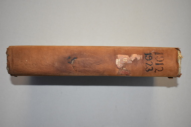
Ledger 10, Letters 1912 1923, 1912
This letter book contains letters and maps and dates from 1912 to 1923. It came from the office of John William Crawley Junior, an engineer, architect and surveyor in private practice in Warrnambool and also the engineer for the Shire of Warrnambool from 1895 to 1935. Hs father, brother and son were also engineers and worked in that capacity or as the Shire Secretary in the Shire of Warrnambool, with the Crawley family recording a total of 132 years of service to the Shire. The Shire of Warrnambool existed from 1863 to 1994. The letter book was passed on to John Crawley’s son, Rolf who was the engineer for the Shire of Warrnambool from 1935 to 1968. It then passed into the possession of Michael Hand who took over the private surveying practice of Rolf Crawley in Warrnambool. The Warrnambool and District Historical Society acquired the letter book, along with several other Crawley ledgers, from the estate of Michael Hand. This letter book is of considerable interest as it contains letters and maps drawn up by John William Crawley, a Shire of Warrnambool engineer for 40 years. It will be helpful to researchers. This is a black hard cover letter book with brown binding on the cover edges and the spine. Parts of the cover have been worn away. The spine once had gold lettering but this is mostly worn away. The book has 743 pages of handwritten letters and maps and an alphabetical index at the front. The pages are water stained.‘Letter Book 1912, 1923’john william crawley junior, warrnambool, rolf crawley, warrnambool, shire of warrnambool -
 Warrnambool and District Historical Society Inc.
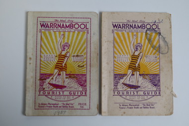
Booklet - Warrnambool Tourist Guide, Warrnambool Progress Association, Warrnambool On The Sea Tourist Guide, The Ideal City, Where to Go and What to See, 1936
Warrnambool Tourist Guide 1936This is a booklet with a buff-coloured cover featuring an illustration of a woman water skiing. The back cover has blue printing. The pages contain a fold-out map, advertisements, printed text and black and white photographs. The pages have been stapled and then glued.non-fictionWarrnambool Tourist Guide 1936tourism in warrnambool, warrnambool progress association -
 Lara RSL Sub Branch
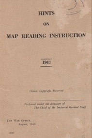
Booklet, Hints of Map Reading Instruction 1943, 00/08/43
Used to instruct the serviceman how to read and question learnt material about map reading. The map as a plan, as a reference point, a measurement of distance, a relief and direction in any situation Paper Booklet with 24 pages that have faded to a beige colour A5 in size ReservedFront page has the name of the booklet with added date 1943. Crown Copyright. Prepared under the direction of the Imperial General Staff The War Office August 1943 22307booklet, map instruction, 1943 -
 Stawell Historical Society Inc
Book - Country Fire Authority, Region 17 Rural Directory 2nd Edition 1990
Maps for use of C.F.A.Bound Plastic Cover over pale green soft cover with CFA Logo. green & white zebra crossing.Country Fire Authority Region17 Rural Directory 2nd Edition 1990. Published by the C.F.A. Mapping Association Inc. Sold by same, at R 17 H.Q. 119 Firebrace Street Horsham Firebrace 3400. -
 Bendigo Military Museum
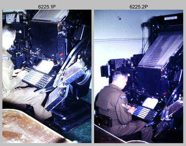
Photograph - Cartographic Production – Army Survey Regiment, Fortuna, Bendigo, c1960 -1975
This is a set of 10 photographs of Cartographic Squadron technicians undertaking map production tasks in at the Army Survey Regiment, Fortuna, Bendigo circa 1968 to 1975. Production was undertaken on the top floor of Fortuna Villa. The Fotosetter type setting machine shown in photos .1P and .2P. replaced the letterpress method of type production in 1956. CPL Arty Lane specialised in the operation of the Fotosetter type setting machine for many years. For more information on the Fotosetter, see page 71 of Valerie Lovejoy’s book 'Mapmakers of Fortuna – A history of the Army Survey Regiment’ ISBN: 0-646-42120-4. The computer based Editwriter Model 7500 typesetting system shown in photos .3P and .4P. was introduced in 1975 as a replacement to the aging Fotosetter. It was operated by a specialised technician, who generated a large variety of map type styles and sizes quickly and reliably, as well as text panels. Output on Copy proof adhesive backed stripping type film replaced messy wax and spray adhesives in 1978. The Editwriter capability supported all RASvy units and its contractor type setting requirements. The Aristo Co-ordinatorgraph shown in photos .5P to .7P was introduced in 1962. It was a large heavy steel framed light table with a scribing head that moved in a XY direction using a vernier calibrated measuring scale to 0.001 of an inch. Whilst hand operated it was much quicker and accurate than manual grid and graticule calculation, plotting and scribing. The history of co-ordinatorgraphs is covered in more detail with additional historic photographs, in pages 50 to 51 and page 88 of Valerie Lovejoy’s book 'Mapmakers of Fortuna – A history of the Army Survey Regiment’ ISBN: 0-646-42120-4. The scribing process as shown in photos .8P to .9P was the cartographic process of drafting features such as drainage, relief, vegetation, roads and culture on specially coated map reproduction material. The cartographic technician scribed out the map feature such as a contour to a specified line width on the map sheet, using a tool affixed with a sapphire tipped cutter. The quality control edit (Proving) stage of map production shown in photo .10P was the first opportunity to independently and systematically inspect a proof of the map.This is a set of 10 photographs of cartographic Squadron technicians undertaking map production tasks at the Army Survey Regiment, Fortuna, Bendigo, c1968 to c1975. The photographs were on 35mm colour slides and scanned at 96 dpi. They are part of the Army Survey Regiment’s Collection. .1) to .2) - Photo, colour, c1968, Fotosetter type setting machine, CPL Arty Lane. .3) to .4) - Photo, colour, c1975, Typesetting machine, ‘Editwriter’ Model 7500. .5) - Photo, colour, c1960s, PTE Desi Asaris and CPL Kalen Sargent operating Aristo Co-ordinatorgraph equipment. .6) - Photo, colour, c1970s, L to R: CPL Desi Asaris, CPL John Bennett, operating Aristo Co-ordinatorgraph equipment. .7) - Photo, colour, c1970s, L to R: CPL John Bennett, CPL Desi Asaris operating Aristo Co-ordinatorgraph equipment. .8) - Photo, colour, c1970s, L to R: CPL Desi Asaris scribing drainage, CPL John Bennett. .9) - Photo, colour, c1970s, CPL Desi Asaris scribing drainage. .10) - Photo, colour, c1970s, L to R: CPL Desi Asaris, CPL John Bennett and their supervisor WO2 Roger Rix inspecting features on an aeronautical chart proof. .1P to .10P There are no annotations stored with the 35mm slides.royal australian survey corps, rasvy, army survey regiment, army svy regt, fortuna, asr, carto -
 Bendigo Historical Society Inc.
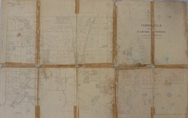
Map - JACK FLYNN MAP COLLECTION: GLADSTONE AND BENDIGO - TARNAGULLA, 13th May 1922
Map 388. Counties of Gladstone and Bendigo a Map of Tarnagulla with Kingower, Glenalbyn, Inglewood, Waanyarra and Laanecoorie boarding. The map is in poor condition and in several pieces. It has been previously taped together. The front page is of red card with white tape along the spine to hold it together, top half Tarnagulla is hand written in black lead on a label with blue trim.By Authority A.J. Mullett, Government Printer, Melbourne. Photo-Lithographed at the Department of Lands and Survey, Melbourne by W.J. Butson. 13.5.22map, bendigo, tarnagulla, tarnagulla, kingower, glenalbyn, laanecoorie, inglewood. -
 Bendigo Historical Society Inc.
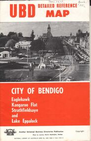
Document - UBD DETAILED REFERENCE MAP - CITY OF BENDIGO
Universal Business Directories Publication UBD Detailed Reference Map - City of Bendigo Eaglehawk, Kangaroo Flat Strathfieldsaye and Lake Eppalock Single page folded map sheet providing three maps: * Bendigo, Eaglehak & Shire of Strathfieldsaye on main sheet * Eppalock & Environs * Kangaroo Flat hand written date June 1975, and 50 cents costUniversal Business Directories Publication -
 Melbourne Tram Museum
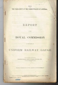
Document - Report, Commonwealth of Australia, "Report of the Royal Commission on the matter of Uniform Railway Gauge", Oct. 1921
Report - 42 pages, + 6 maps, printed on foolscap and folded map sheets, edge stapled titled "Report of the Royal Commission on the matter of Uniform Railway Gauge" - dated 12/10/1921. Looks at the Australian railway system and makes recommendation for a uniform gauge for the rail system, technical issues, change of gauge, rollingstock, costs and existing system maps.Has in top right hand corner a stamp "Received Nov. 18, 1921"trams, tramways, railways, gauge -
 Warrnambool and District Historical Society Inc.
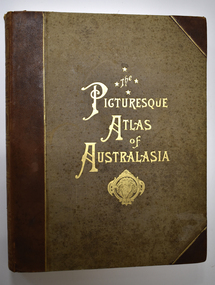
Book - Antiquarian Book, Hon Andrew Garran, Picturesque Atlas of Australasia Volume Two, 1886
A contemporary and geographical record of Australasia in the 19th centuryThis is a leather covered book of 801 pages. The cover is decorated with gold panels of fruit and has gold lettering on the spine. The pages have gilt edges. It contains text, sketches, lithographs, maps and five loose maps. non-fictionA contemporary and geographical record of Australasia in the 19th centuryaustralasian history, antiquarian books, picturesque atlas of australasia, warrnambool, picturesque atlas of australasia volume 2 -
 Orbost & District Historical Society
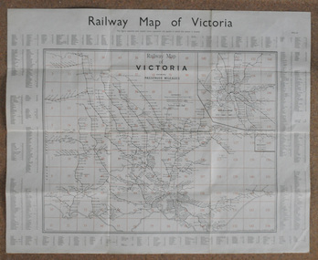
map, Railway Map of Victoria, 1.8.1965
The Bairnsdale-Orbost railway was opened in 1916 to serve the agricultural and timber industry. Because of the decline in traffic and heavy operating costs, the line was finally closed in August, 1987.This item is associated with the history of the Orbost-Bairnsdale railway line and therefore reflects the role that the rail line played in the social and economic history of Orbost.A large rectangular shaped paper map of all railway stations in Victoria. It is dated 1st August 1965. It is divided into grids. Stations are listed around the map. A key is provided and each station has a grid reference.map-railway victorian-railways -
Bendigo Historical Society Inc.
Map - PANNOOMILLOO : COUNTY OF BENDIGO, 17-12-13
Map. Pannoomilloo, County of Bendigo, Pannoobamawm, Warragamba, Milloo, Diggorra. Photo-Lithographed at the Department of Lands and Survey, Melbourne by W.J. Butson 17-12-13, Price 1/-. (number 82 in map cupboard 1)W.J. Butson.map, bendigo, pannoomilloo -
Bendigo Historical Society Inc.
Map - CAMPBELL COLLECTION: BENDIGO & DISTRICT MAPS, 16-5-29
Map. Egerton, Parishes of Egerton and Whirrakee, scale 20 chains to 1 inch. Total area 5401 acres. Prepared in W.P.B. from A. and C.L. Plans by W.J. Galbraith (number 376 in map cupboard 1)W.J.Galbraithmap, bendigo, agricultural lands -
Bendigo Historical Society Inc.
Map - CAMPBELL COLLECTION: BENDIGO & DISTRICT MAPS, 5-4-28
Map. Sedgwick, Parishes of Strathfieldsaye, Lyell and Sedgwick. Scale 20 chains to 1 inch.Total area 5372 acres. Prepared in W.P.B. from C.l. and A. Plans by W.J. Galbraith. (number 374 in map cupboard 1)W.J.Galbraithmap, bendigo, agricultural lands -
Bendigo Historical Society Inc.
Document - ROBERT DENIS KELLY COLLECTION: MAP OF ELECTRIC RAILWAYS OF LONDON
Document: map of the electric railways of London. Buff coloured document, printed in black, white and red on front cover. Folds into 9 x 14 map. Details include tourist destinations, descriptions of costs etc.Johnson, Riddle & Co. Ltd. London.person, robert denis kelly, world war 1, robert denis kelly collection, france, london, underground, electric railway -
 Whitehorse Historical Society Inc.
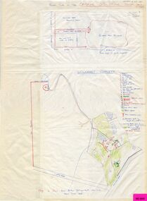
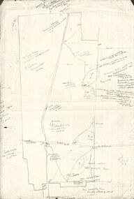
Map, Schwerkolt property and rough plan of old stone house, 1993
Map drawn by Arthur SchwerkoltMap drawn by Arthur Schwerkolt in 1993 from memory assisted by survey map of 1902. Covering letter from Glyn France [also at ND1367 (G-H-S-C 46) gives extra details.Map drawn by Arthur Schwerkoltschwerkolt cottage, schwerkolt, arthur, whalen, rosalie, france, glyn -
Bendigo Historical Society Inc.
Map - PANNOOBAMAWM : COUNTY OF BENDIGO, 1957
Map. Pannoobamawm, County of Bendigo, Terrick Terrick East, Wanurp, Pannoomilloo, Bamawm, Turrumberry, property allotments. Drawn and reproduced at the Department of Lands and Survey, 1957, Price 2/-. (number 410 in Map Cupboard 1 ).W.M. Houston, Government Printer, Melbourne.bendigo, hospital -
Bendigo Historical Society Inc.
Map - NERRING : COUNTY OF BENDIGO, August 1952
Map. Nerring, County of Bendigo, Leichardt, Marong, Sandhurst, Huntly, Neilborough, Yarraberb. Drawn and Reproduced at the Department of Lands and Survey, Melbourne, Victoria, August 1952, Price 2/-.( number 409 in Map Cupboard 1).J.J. Gourley, Government Printer, Melbourne.bendigo, hospital -
 Bendigo Historical Society Inc.
Map - PETER ELLIS COLLECTION: MAP AREA AROUND MITIAMO
Copy of a hand drawn map of an area near Mitiamo with various plants/trees, features and Aboriginal Water Holes drawn in. Also a smaller copy of the top part and two smaller copies of the lower half of the map.map, victoria, rushworth/whroo, peter ellis collection, mitiamo area, aborigine water holes -
 Warrnambool and District Historical Society Inc.
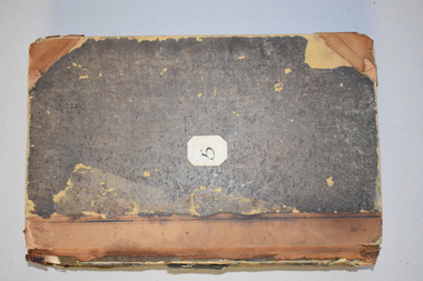
Letter book 5, 1910
This letter book has letters, invoices and sketch maps and dates from 1910 to 1914. It came from the office of John William Crawley, Junior, an engineer, surveyor and architect in private practice in Warrnambool and also the official engineer for the Shire of Warrnambool from 1895 to 1935. His father, brother and son were also engineers and worked in that capacity or as the Shire Secretary for the Shire of Warrnambool, with the Crawley family recording a total of 132 years of service to the Shire. The letter book was passed on to John Crawley’s son, Rolf, engineer for the Shire of Warrnambool from 1935 to 1968. The letter book then came into the possession of Michael Hand who took over the private surveying business of Rolf Crawley in Warrnambool and the Warrnambool and District Historical Society has acquired the letter book, one of several Crawley ledgers, from the estate of Michael Hand.This letter book is of considerable significance as it contains maps, plans, sketches and written information, the work of John William Crawley, Junior, the Shire of Warrnambool engineer for 40 years. It will be very useful for research purposes. This is a brown-covered letter book of 750 pages with a mottled blue inside lining. The pages contain an alphabetical index and copies of handwritten letters and sketch maps and plans. There is one loose letter dated 1937. The pages are somewhat stained and the spine on the cover has been torn away. There is a mauve stamp on the first page. ‘5’ ‘Rolf L. Crawley, Civil Engineer, Drainage and Water Supply Engineer, Licensed Surveyor, Registered Architect, Warrnambool’ rolf crawley, warrnambool, john william crawley, junior, warrnambool -
Lorne Historical Society
Print - Framed coloured print, Print Accommodation Lorne to 1950, Exact date Unknown
Rob Coy depicted the 22 following buildings with a map 1. Bonnie Doon 2. Gracedale 3. Cora Lynn 4. Carinya 5. Kia-Ora 6. Kalimna 7. Argyll 8. Minapre 9. Erskine House 10.Hotel Pacific 11. The Cumberland 12. Riverview 13. Hotel Lorne 14. The Chalet 15. Santoy 16. Clovelly 17. Yendallock 18. Nenthorne 19. Quamby 20. Ben-My-Kree 21. Glenora 22. Ozone House Rectangular framed color print of Rob Coy ‘ sketch Accommodation Lorne to 1950. The guest houses were, Bonnie Doon, Gracedale, Cora Lyn, Karinya, Kia Ora, Kalimna, Argyle, Minapre, Erskine House, Hotel Pacific, Cumberland, Riverview, Lorne Hotel, Chalet, Santoy, Clovelly, Yendaloch, Nenthorne, Quamby, Ben - My Cree, Glendora, Ozone House and a small map showing the locations of the accommodation. We believe this this is the original print. The colors are mainly blue and light tan. rob coy, lorne, accommodation, hotels, guest houses, pubs, erskine house -
 Gippsland Vehicle Collection
Book, Darge, Victoria's Leaders in the Motor Car World, 1911 (estimated); Based on make & models of vehicles, maps, and articles
... 1911 (estimated); Based on make & models of vehicles, maps ...Book of "Darge" photographs c.1911. Algenon Darge was a noted photographer in Melbourne around the commencement of the 20th century. 124 pages"The property of Bramwell" "thanks Fred" "Fred Armylope\19/7/68"melbourne, melba, dame nellie melba, gippsland, cars, darge, broadbent, road map, advertisements, touring, james flood, hudson, berliet -
 Bendigo Military Museum
Photograph - Detachment - Army Survey Regiment, Bonegilla, Victoria, c1973
This is a set of three photographs of personnel from the Detachment - Army Survey Regiment taken in front of its main map production building at Bonegilla, Victoria in c1973. This cartographic map production sub-unit of the Army Survey Regiment operated in buildings owned by the School of Military Survey from 17th of June 1970 to the 30th of September 1985. A total of 800 topographic maps ranging in scale from 1:25,000 to 1: 250,000 scale were completed. A major focus of production in the 1970s was the cartographic completion of the Papua-New Guinea 1:100,000 map series and the Flexiflow quality control system was developed as a tool to coordinate production. The Flexiflow system comprised a series of job plans and charts linked to a task allocation to resource magnetic planning board. Using critical path analysis and task prioritisation, complex job planning was efficiently scheduled, and re-prioritisations readily made. Reproduction requirements were effectively coordinated by way of weekly courier to the Army Survey Regiment at Bendigo. Supervisors and technicians fully embraced the system as they could understand their role, others around them and the positive production achievements. WO1 Bill Boyd (who does not appear in this photograph) was the technical warrant officer for 11 years at the Detachment was awarded the OAM, the Order of Australia Medal for leading the development and the implementation of the Flexiflow system. By mid-1982, production of maps at these scales was undertaken digitally on Bendigo’s AUTOMAP 2 system and the Detachment reverted to production of small-scale large format RAAF aeronautical charts. Detachment personnel managed to produce 18 charts in the following two years, which was an impressive achievement for the staff, given major differences in format, specification and scales. Development of digital production of aeronautical charts in 1984-85 led to gradual reduction in production output and contracting out production was instigated to meet the shortfall and as a consequence the Detachment closed in September 1985. See pages 177 to 180 of Valerie Lovejoy’s book 'Mapmakers of Fortuna – A history of the Army Survey Regiment’ ISBN: 0-646-42120-4. for more information on the history of the Detachment at Bonegilla.This is a set of three photographs of the Detachment - Army Survey Regiment taken in front of the main map production building at Bonegilla, Victoria in c1973. The photographs were printed on photographic paper and are part of the Army Survey Regiment’s Collection. The photographic proofs were scanned at 600 dpi. .1) to .3) - Photo, black & white c1973. Back Row L to R: Peter Simpson, Chris Edwards, unidentified (x2), Colin Harden, Rowan Gillies, Bob Rowley OAM, Steve Hansen, Stu Thaxter. Centre Row L to R: Kevin Boehm, Dennis McCarthy, Peter Cross, unidentified, Brian Ryan, unidentified, Ian Marner, unidentified, Phil Smalley. Front Row L to R: Geoff Haynes, Bruce Wetzig, Dave Thompson, unidentified, OC Bob Roche, Ike Lever, John McCulloch, Dick Barwald, unidentified. There are no personnel annotated.royal australian survey corps, rasvy, army survey regiment, detachment - army survey regiment, army svy regt, asr -
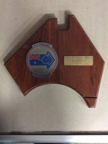 Phillip Island and District Historical Society Inc.
wooden plaque, Australia Day Citizen Award, 1993
Janet was a long standing volunteer in the local community, especially for Red Cross.Dark wooden plaque in shape of map of Australia. Has 2 metal plaques.Australia Day Citizen Award. Shire of Phillip Island Janet Crilly 1993janet crilly, red cross, volunteers, trophies & awards -
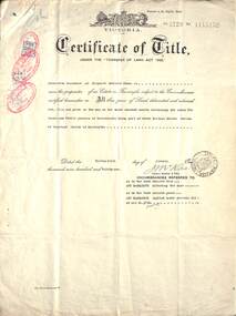 Ringwood and District Historical Society
Document, Land Title Certificate for Henrietta Greenwood of Ringwood, Vic. - 31st January, 1931. (4 pages)
Certificate of Title - Henrietta Greenwood, Ringwood, Victoria, including Transfers and map of subdivisionIncludes transfers as part to Ernest Allan Devenish, 27th October, 1938 Lillian Alice Clegg, 10th July, 1936 Francis Leslie Little and Rose Little, 12 November, 1940 Ralph Wigley, 25 November, 1937 Alan Geoffrey Clegg, 25 November, 1937 Phillip McKinley, 8 May, 1941 John Andrew Pearson, 11 May, 1938 Paul Clegg, 8 May, 1941 The Mayor, Councillors and Burgsses of the Borough of Ringwood, 18 June, 1941 Ruby Grace Holloway, 15 October, 1941 William Herbert Holloway, 28 June, 1949 -
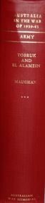 Lara RSL Sub Branch
Book, Australia in the War of 1939-1945 Tobruk and El Alamein ARMY Author Barton Maughan, First Published 1966
Australia in the War 1939 - 1945 From March 1941 - December 1942 Historical record part of a seriesAustralia in the War of 1939-1945 - Tobruk and El Alamein Maps, illustrations, photographsAustralian War Memorialtobruk, el alamein, army, wwii, palestine, lebanon, german invasion of greece and yugoslavia, bismark, malaya, pearl harbour, darwin, crete, churchill, faddon, curtin -
 Lara RSL Sub Branch
Book, Australia in the war of 1939-1945 CIVIL The role of science and industry. Author D.P. Mellor, First published in 1958
An account of the part played by science and industry in the defence of Australia during the war 1939-1945The role of Science and IndustryAustralia in the War of 1939-1945 - The Role of Science and Industry Photographs, maps, illustrations Canberra Australian War Memorialmobilising industry for war, mobilising science for war, raw materials - steel, machine tools, fuel and power, guns, torpedoes and mines, chemical warfare, radar, meteorology, inventions -
 Federation University Historical Collection
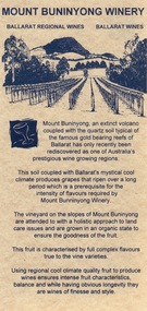
Card - Card - Advertising, ZILLES COLLECTION: Advertising Card promoting Mount Buninyong Winery
Zilles Printers was begun by Lewis Zilles in the early 1930s. It was in McKenzie Street Ballarat. His son Jeffrey also became a printer - letterpress, offset and screen printer. The business became Zilles Printers/Graphics and was in Armstrong Street and later Bell Street Ballarat. Mount Buninyong has become one of Victoria's prestigious wine growing areas due to the soil and the climate. Double-sided light beige card with black print. Map showing location.zilles printers, ballarat, mount buninyong, winery, -
 Phillip Island and District Historical Society Inc.
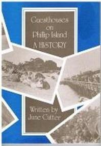
Book - Book, softcover, Guesthouses on Phillip Island : a history, 1987
Historical169 p. : ill., facsims., maps, plans ; 25 cm. ISBN 0731600088 phillip island, accomodation, guesthouses, history, housing, julie cutter, 1987, broadwater guesthouse cowes phillip island, carisbrooke guesthouse cowes phillip island, bayview house, osbourne park guesthouse phillip island, erehwon guesthouse, isle of wight hotel -
Phillip Island and District Historical Society Inc.
Book, Western Port chronology 1798-1839 : exploration to settlement, 1984
Extracts from log books and journals of explorers and travellers from the time George Bass entered and sketched the harbour in 1798, combined with rare charts and plates. This compilation brings life to European activity at Western Port during the thirty-seven years that preceded Melbourne's founding. xiv, 110 p. : ill., facsims., maps ; 24 cm. ISBN 0959065202 -
 Greensborough Historical Society
Flyer - Leaflet, Watsonia Heights Primary School Fete 2020 WH4935, 14/03/2020
The Watsonia Primary School Fete, held on Saturday 14th March, was one of the last activities held before the Covid lockdown in 2020Single page, printed in colour on front and black and white map of school on back.watsonia primary school, school fetes, henry street greensborough