Showing 177844 items matching "ely-street"
-
 St Kilda Historical Society
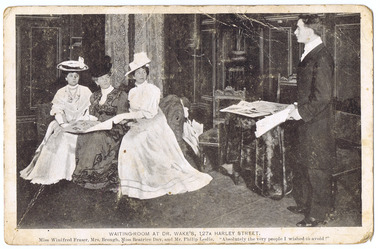
Photograph, Waiting Room at Dr Wake's, 127A Harley Street
Postcard 'Dr Wake's Patient' Seriesblack and white postcard unmounted, original, fair conditionOn front: Waiting-room at Dr Wake's, 127A Harley Street, Miss Winifred Fraser, Mrs Brough, Miss Beatrice Day and Mr Philip Leslie. "Absolutely the very people I wsihed to avoid!" -
 Kew Historical Society Inc
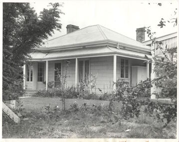
Photograph, Houghton, Princess Street, circa 1960, c. 1960
This work forms part of the collection assembled by the historian Dorothy Rogers, that was donated to the Kew Historical Society by her son John Rogers in 2015. The manuscripts, photographs, maps, and documents were sourced by her from both family and local collections or produced as references for her print publications. Many were directly used by Rogers in writing ‘Lovely Old Homes of Kew’ (1961) and 'A History of Kew' (1973), or the numerous articles on local history that she produced for suburban newspapers. Most of the photographs in the collection include detailed annotations in her hand. The Rogers Collection provides a comprehensive insight into the working habits of a historian in the 1960s and 1970s. Together it forms the largest privately-donated collection within the archives of the Kew Historical Society.The National Trust citation in 1960 stated that Houghton (dem.) appeared to date from the 1850's and might possibly be of prefabricated construction. Although modified, it contained substantial external evidence of its early construction and is one of the few buildings remaining in Kew from this early period. It was used at one stage as a doctor's surgery and residence - the surgery being at the rear of the property. The image was used by Dorothy Rogers in 'A History of Kew' (1973), facing page 128.Houghton. Built prior to 1860. Occupied once by Miss Bowden. Now cottage belongs to War Widows Homes, Princess Street. Miss Bowden's cottage. Now Mrs Gahan. Built prior to 1860.houghton, princess street, kew, dorothy rogers -
 Federation University Historical Collection
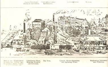
Image, Ballarat School of Mines from Albert Street, Ballarat, c1904
This image was reproduced in the Ballarat School of Mines Handbook and Prospectus, 1905.Copy of a line drawing of the Ballarat School of Mines from Albert Street, Ballarat, including the battery and metallurgical laboratories, chlorination plant and roasting furnace, cyanide plant, engineering laboratory and the Ballarat School of Mines Botanical Gardens. The original of this image is Cat. No. 4774.ballarat, school of mines, battery, metallurgy, chlorination plant, roasting furnace, cyanide plant, engineering, laboratory, museum, assay, mine, m3334, ballarat school of mines botanical gardens -
 Federation University Historical Collection
Letter, Grant Street Terraces, 1992
.1) 5 pages of correspondence relating to a request for survey of Crown Allotment 11, Section 11, Parish of Cardigan (included plan) .2) 3 pages relating to a tender for Bluestone / drystone terraces along the Grant Street frontage of the Ballarat School of Minesballarat school of mines, grant street, gillies street, j. winter, e.a. wynne, w.b. ochiltree, ballarat industrial school, prince of wales park, ballarat golf club -
 Whitehorse Historical Society Inc.
Photograph, The Railway Crossing from Station Street, 1/06/2009
One of a collection of photographs taken of the Nunawading Railway Station prior to the lowering of the railway line and building of the new railway station on the western side of Springvale Road so that the Springvale Road Rail Crossing can be eliminated.Black & white photograph of he precinct surrounding the Nunawading Station and the Springvale Road Railway crossing. This photograph is of the crossing from Station Street. The liquor on the corner of Springvale Road and Oval way is in the background. See NP 3545 to NP3567 for the complete set of photographsnunawading railway station, springvale road nunawading, redevelopment of railway line/springvale road., oval way nunawading -
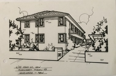 Kew Historical Society Inc
Drawing - Property Illustration, Margaret Picken, 6/29 Mary Street, Kew, 1989
After training as a Cartographic Draftsman within the mining industry, I worked as a property illustrator for real estate firms in the eastern suburbs of Melbourne for 23 years from 1983. I initially photographed houses with a Polaroid camera and made a 'thumbnail' sketch while there. The photos were used to scale off a sketch in pencil and then that sketch was overlaid with drafting film and the 'pen and ink' completed. The pens I used were the Rotring ‘Rapidigraph’ drafting pens. The ink was also made by Rotring (German).The film was ‘Rapidraw’, polyester drafting film, double matte. It takes a very fine line and doesn’t bleed. As well as house sketches, there were often floor plans and site plans ordered. Aerial sketches were ordered when the property needed an overall view. (Margaret Picken, 2020)This drawing is one of a series created by Margaret Picken for a number of real estate agents in Melbourne between 1983 and 2005. Each work is signed and dated by the artist.Gift of Margaret Picken, 2020Unit 6 in a two storey, variegated cream brick group of apartments. Built by the Kew Baptist Church in 1964 on the grounds of 'Rangeview' and using that name. Pen and ink architectural drawing on drafting film of 6/29 Mary Street, Kew by Margaret Picken. 6/29 MARY ST., KEW / MARGARET PICKEN '89 / WOODARDS ~ KEWartist -- margaret picken 1950-, architectural drawings -- houses -- kew (vic.), 6/29 mary street - kew (vic). -
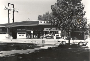 Wodonga & District Historical Society Inc
Photograph - Codling Collection 01 - High Street West - Tower Place, 1970s
Miss Olive Codling was a Foundation Member and a Life Member of the Wodonga Historical Society. Many of her prize-winning photos are held in the Society Collection. She also held a range of roles and committee positions in a wide range of Wodonga community organisations. These included the Horticultural Society, the Wodonga Arts Council, the Wodonga Camera Club and the Wodonga Lapidary Club. This photo collection is significant as it documents how the businesses and buildings in Wodonga have evolved and contributed to community throughout the 20th century.High Street West, Tower Place on the left. Businesses shown include Wodonga Warehouse Centre, Rob Lacey Photography, Vid Hire and East West Airlines . Tower Place was built by Arthur Dunstan, owner of A. Dunstan & Sons Hardware and timber mills. On sign above building "Tower Place", on front of building on left "WODONGA WAREHOUSE CENTRE"wodonga businesses, high st wodonga, wodonga warehouse centre, tower place -
 Port Melbourne Historical & Preservation Society
Postcard - Fountain Inn, Port Melbourne, WTP Post Card, Fountain Inn, Crockford Street, Port Melbourne, Victoria, 1892
Appears to have belonged for a time to licensee of Fountain Inn "pudney" (except licensee at the time is listed as Joseph Ballhausen). If 1892, cable tram has just gone in, so dispute the marked date."Fountain Inn, Crockford Street, Port Melbourne, Victoria". A postcard of the Fountain Inn (deemed 1892). Sender has written "Greetings from Port Melbourne" across the front. Hand tinted photo shows cable car and horse cart. Printed in Germany."To dear Aunt Mary with fond love from Bessie" Also "greetings from Port Melbourne" "1892" "56 years ago at 1945 Pudney Licensee"business and traders - hotels, built environment - commercial, cable trams, transport - tramways, fountain inn -
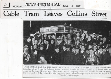 Melbourne Tram Museum
Newspaper, The Sun, The Herald, "Last cable car on the Collins Street - Victoria Bridge", 15/7/1929
Newspaper clipping from the Melbourne The Sun News Pictorial, 15/7/1929 about the closure of the Victoria Bridge line in Victoria St from Brunswick St. Has a photo of the event at the Collins St, Driven by Gripman Cubitt. Second copy is photo printed on heavy paperYields information about the last Victoria St cable tram.Newspaper Clipping - on newsprint or heavy paper. The timeline gives the date of closure of the Brunswick St to Victoria Bridge line as Saturday 13 July 1929. Titled "Last cable car on the Collins Street - Victoria Bridge" Checked for The Argus in Trove - not shown on line.trams, tramways, conversion, victoria bridge, closure, collins st, cable trams, victoria st -
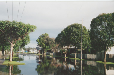 Lakes Entrance Historical Society
Photograph, Bulmer Street in flood Lakes Entrance Victoria, 2004 c
Colour photograph showing flood water in Bulmer Street looking south towards the Cunninghame Arm Lakes Entrance Victoria. Also second colour photograph taken at same time plus another of a house under construction following a mini tornado in 2005floods, naturalm disasters, township -
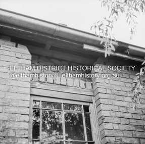 Eltham District Historical Society Inc
Negative - Photograph, J.A. McDonald, Old house, Susan Street, Eltham, c. 1962
Williams house, Susan StreetRecord of various Shire of Eltham infrastructure works undertaken during the period of 1952-1962 involving bridge and road reconstruction projects, sometimes with Eltham Shire Council Project Reference numbers quoted. It was during this period that a number of significant improvements were made to roads and new bridges constructed within the shire that remain in place as of present day (2022). In many situations, the photos provide a tangible visible record of infrastructure that existed throughout the early days of the Shire. The album was put together by or under the direction of the Shire Engineer, J.A. McDonald.eltham, houses, susan street, williams house -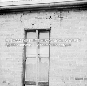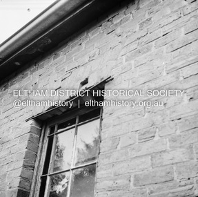
 Greensborough Historical Society
Photograph - Digital image, Cars on Flintoff Street Greensborough, 1976c
Cars on a Greensborough street, 1976.Digital copy of black and white photographpeter varalla, greensborough -
 Greensborough Historical Society
Photograph - Digital image, Frank Solomon, Parking, Main Street Greensborough, 04/06/2010
Parking on Main Street, Greensborough.Shows the changing face of the Greensborough shopping stripDigital copy of colour photographmain street greensborough -
 Tatura Irrigation & Wartime Camps Museum
Photograph, Hogan Street 1932, 2001
Hogan Street looking east.hogan street, photograph, building -
Stawell Historical Society Inc
Postcard, Court House in Patrick Street
Court House Patrick Street .Note Card With Print of Stawell Court House (Patrick St). One of Six Note Cards Historic Stawell Buildings By Mrs. Jan Bosher.J. Bosher: Stawell Court Housestawell building, court house -
 City of Ballarat Libraries
Photograph, Eyre Street, Ballarat circa 1919
Eyre Street facing east.eyre street, ballarat, ballarat central, trees -
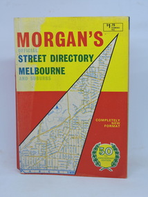 Kilmore Historical Society
Morgan's Street Directory Melbourne, Morgan's Official Street Directory Melbourne and Suburbs, c1966
c1966 Melbourne Street Directory.Soft card cover. 150 maps plus Index. 380 pp. Good condition.Nilmelbourne street directory -
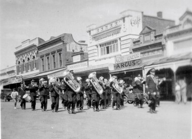 Stawell Historical Society Inc
Photograph, Stawell Brass Band in Main Street 1948-1949
Brass Band - Main StreetReverse of Brownie Photo: 17stawell entertainment -
 Federation University Historical Collection
Card - Card - Business, ZILLES COLLECTION: Business cards for Lewis Zilles Printers, Mackenzie Street Ballarat, 1930s
Zilles Printers was begun by Lewis Zilles in the early 1930s. It was in McKenzie Street Ballarat. His son Jeffrey also became a printer - letterpress, offset and screen printer. The business became Zilles Printers/Graphics and was in Armstrong Street and later Bell Street Ballarat. The business / advertising cards are for Lewis Zilles, founder of the printing company. All show the address for Mackenzie Street Ballarat. Two of the cards have a calendar for 1934. Cards give businesses information on how Zilles through design can help promote their products -Seven cards various sizes and coloursZilles name and addresszilles printers, lewis zilles, mackenzie street, ballarat, business cards, maker of quality printing -
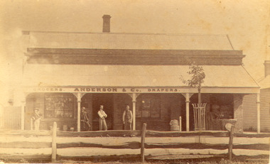 Bacchus Marsh & District Historical Society
Photograph, Anderson's Store, Main Street, Bacchus Marsh circa 1870s-1890s
This store in Main Street Bacchus Marsh was first opened by James Young in November 1866. In October 1869 it was purchased by William Anderson and was operated by members of the Anderson family until 1971. The site of the store was on the southern side of Main Street on the eastern side of Eddie Toole Park. On the opposite side of the street was the site of the former Post Office on the northern side of Main Street. The store was first named the Border Mills Store during James Young's ownership and was later known as the Border Store (Anderson & Co.).Small black and white photograph showing Anderson’s store. It shows a large stone building with a corrugated iron verandah which bears a painted sign of the name of the business: GROCERS. ANDERSON & Co. DRAPERS. Behind a brick parapet rises a hip roof with one chimney visible. Four men stand in casual poses ranged along the verandah. A post and rail fence runs along the road frontage. A tree is planted in an ornamental wrought iron plant protector on the inside of the fence.On the back in decorative print: “ New York Photographic Adelaide Travelling Brand Chas. F. Husband Manager.” In handwriting: Border store built by James Young 1866 owned by Anderson 1869-1972. BMDHS stamp and no. HS 411.shops bacchus marsh vic., anderson's store bacchus marsh, stevenson and mcnicoll 1883 photographs of bacchus marsh and district -
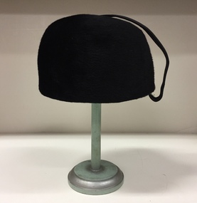 Kew Historical Society Inc
Headwear - Black Felt and Grosgrain Hat, R & M Dower, 1960s
R&M Dower was a major millinery partnership located at 146 High Street, Kew in the 1940s and 1950s. Examples of this millinery firm's hats are in other major public collections, including the National Gallery of Victoria.The Kew Historical Society’s fashion and design collection is comprised of costumes, hats, shoes and personal accessories. Many of these items were purchased or handmade in Victoria; some locally in Kew. The extensive hat collection comprises items dating from the 1860s to the 1970s. Most of the hats in the collection were created by milliners for women. There are however a number of early and important men’s hats in the collection. The headwear collection is particularly significant in that it includes the work of notable Australian and international milliners.A circular black velvet brimless woman’s hat with a ribbed grosgrain strap at the back. The hat includes a small label identifying the maker as R&M Dower of 146 High Street, Kew.Label: "Phone WM8527 / R&M Dower. 146 High Street Kew"fashion accessories, hats, women's clothing, r&m dower -
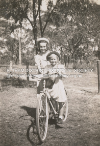 Eltham District Historical Society Inc
Photograph, Pam Ingram (on bike) and Valerie Feldbauer at Thomas Street, Eltham, c.1948
Pam is on the bike which belonged to her cousin Valerie Feldbauer (later Waller) Thmas Street was named after their grandfather, Thomas Teagle and many of the Teagle family homes were in this street.pamela lorraine ingram, eltham, thomas street, valerie feldbauer, pamela thoonen (nee ingram), valerie waller (nee feldbauer), pam thoonen (nee ingram) collection -
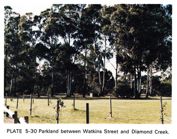 Eltham District Historical Society Inc
Work on paper (Sub-Item) - Photograph, Parkland between Watkins Street and Diamond Creek, 1976
Colour photograph of Parkland between Watkins Street and Diamond Creek identifed as Watkins Street Reserve. Open green space surrounded by eucalyptus trees. Young plants are staked in the foreground of the imagediamond creek, watkins street reserve, parkland, park -
 Greensborough Historical Society
Photograph - Digital Image, Ken Wandin, All Saints Anglican Church Greensborough. View from Church to Grimshaw Street 1970, 1970_
In 1970, All Saints' Anglican Church was rebuilt on the corner of Church and Grimshaw Streets Greensborough, replacing the timber church. This photograph shows the view from the new church to Grimshaw Street in 1970.Digital copy of colour photographall saints anglican church greensborough -
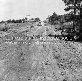 Eltham District Historical Society Inc
Negative - Photograph, J.A. McDonald, Eltham, Susan Street, Jan. 1961
January 1961 Looking towards Dalton Street (present-day Withers Way) Just south of Brougham Street. To the immediate left is the present-day car park for the Elham Leisure Centre. The house on the left is immediately opposite Cromwell street and adjacent to the southwest corner of the Leisure Centre buiding (where the Williams house sits hidden from view)Record of various Shire of Eltham infrastructure works undertaken during the period of 1952-1962 involving bridge and road reconstruction projects, sometimes with Eltham Shire Council Project Reference numbers quoted. It was during this period that a number of significant improvements were made to roads and new bridges constructed within the shire that remain in place as of present day (2022). In many situations, the photos provide a tangible visible record of infrastructure that existed throughout the early days of the Shire. The album was put together by or under the direction of the Shire Engineer, J.A. McDonald.shire of eltham, infrastructure, 1961-01, cromwell street, eltham leisure centre, road construction, susan street -
 Port Fairy Historical Society Museum and Archives
Photograph
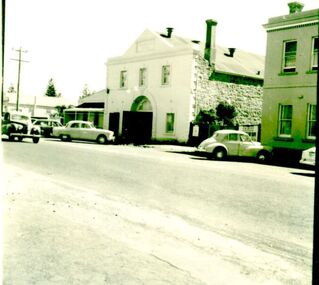
Drill Hall, Bank Street, Port Fairy. This two-storied building was constructed in 1874 as livery stables and was later used for the garrison from c.1885. The structure is symmetrically arranged about a large arched opening and features include the plinth, quions and the parapet. Reconditioned c.2000 when the interior was renovated for functionsBlack and white photograph of the drill hall a two storied rendered building with double doors opening into the streetdefence, hall, drill hall, bank street -
 Wangaratta RSL Sub Branch
Photograph - Unframed Photograph, circa 1910
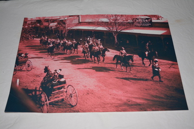
Image depicting Victorian Mounted Rifles parading behind Town Crier along Main Street WangarattaBlack white and dark pink photograph of soldiers on horseback being lead by Town Crier passing horse and buggies along main street.rear of photograph - 1910 Aust Light Horse, Main (Murphy) Street, Wangaratta preceded by Town Crier followed by City Bandlight horse troop, wangaratta, ww1, victorian mounted rifles, circa 1910 -
 Wangaratta Urban Fire Brigade
Photograph
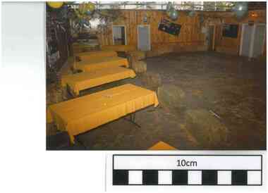
6 - S/O Brian Humpfrys and wife Gail (both seated at a table). Gail has a toddler in a check shirt and auburn hair on her lap. 7 - J. Rosser walking is carrying a bag of potatoes in front of B. Sherritt(child) followingSelection of 15 photographs from the 'Bush Dance' August 1985 held in the motor room of the Ely Street fire station..6 - S/O Brian Humpfrys and wife Gail Bush dance Aug 1985 .7 - J. Rosser B. Sherritt(child) Bush dance 1985 (Aug)