Showing 7909 items
matching former%20ballarat%20gaol
-
 Port Melbourne Historical & Preservation Society
Archive - File, Ewan Ogilvy's Bayside Papers, Box Two: Bayside EES Hearing Transcripts, CSV and Ministerial Advisory Committee Submissions, 1987 - 1998
Ewan Ogilvy, former Melbourne Councillor and also of Community Services Victoria, Inner Urban Ministerial Advisory Committee and Uniting Church's Centre for Urban Research and Action (CURA), was instrumental in social justice approaches to town planning. He and CURA's Social Justice and the City Project funded Port Melbourne community groups protesting against the SCDC development in 1987. His files were presented to the Society in May 2001 on his preparation for leaving Victoria.From Ewan Ogilvy's chronologically organised 'Bayside Papers' relating to the proposed development of Port Melbourne industrial land in the late 1980s: Bound file of EES Inquiry transcripts and CSV and Ministerial Advisory Committee reports, including Ministerial briefing 22.06.1987 to 05.10.1987Signed 'Ewan Ogilvy'; 'Áttachment 2' on first pagetown planning, town planning - proposals shelved - bayside, public action campaigns, environmental issues, public housing, missions to seamen, ewan ogilvy, centre for urban research and action, sandridge city development co pty ltd, scdc, terry chumbley, linton r lethlean, peter atkins, david spokes -
Port Melbourne Historical & Preservation Society
Archive - File, Ewan Ogilvy's Bayside Papers, Box Two: Bayside Press Cuttings, 1987
Ewan OGILVY, former Melbourne Councillor and also of Community Services Victoria, Inner Urban Ministerial Advisory Committee and Uniting Church's Centre for Urban Research and Action (CURA), was instrumental in social justice approaches to town planning. He and CURA's Social Justice and the City Project funded Port Melbourne community groups protesting against the SCDC development in 1987. His files were presented to the Society in May 2001 on his preparation for leaving Victoria.From Ewan OGILVY's chronologically organised 'Bayside Papers' relating to the proposed development of Port Melbourne industrial land in the late 1980s, bound file: 'Bayside' press cuttingsAll items signed 'Ewan Ogilvy'town planning, town planning - proposals shelved - bayside, public action campaigns, environmental issues, public housing, missions to seamen, centre for urban research and action, sandridge city development co pty ltd, scdc, linton r lethlean, ewan ogilvy, barry pullen -
Port Melbourne Historical & Preservation Society
Archive - File, Ewan Ogilvy's Bayside Papers, Box Two: Submissions, 1987
Ewan Ogilvy, former Melbourne Councillor and also of Community Services Victoria, Inner Urban Ministerial Advisory Committee and Uniting Church's Centre for Urban Research and Action (CURA), was instrumental in social justice approaches to town planning. He and CURA's Social Justice and the City Project funded Port Melbourne community groups protesting against the SCDC development in 1987. His files were presented to the Society in May 2001 on his preparation for leaving Victoria.From Ewan OGILVY's chronologically organised 'Bayside Papers' relating to the proposed development of Port Melbourne industrial land in the late 1980s: bound fille containing submissions from Community Services Victoria, Port Melbourne City Council, ALP, Port Melbourne Citizens Action Group, correspondence, minutes and notes from meetings attended etc.Signed 'Ewan Ogilvy', additions to titletown planning, town planning - proposals shelved - bayside, public action campaigns, environmental issues, public housing, missions to seamen, ewan ogilvy, centre for urban research and action, sandridge city development co pty ltd, scdc, linton r lethlean, barry pullen - mlc -
Port Melbourne Historical & Preservation Society
Document, Ewan Ogilvy's Bayside Papers, Box Three: Notice of Referral to Administrative Appeals Tribunal, 1987
Ewan Ogilvy, former Melbourne Councillor and also of Community Services Victoria, Inner Urban Ministerial Advisory Committee and Uniting Church's Centre for Urban Research and Action (CURA), was instrumental in social justice approaches to town planning. He and CURA's Social Justice and the City Project funded Port Melbourne community groups protesting against the SCDC development in 1987. His files were presented to the Society in May 2001 on his preparation for leaving Victoria.From Ewan Ogilvy's chronologically organised 'Bayside Papers' relating to the proposed development of Port Melbourne industrial land in the late 1980s: Notice of Referral to Administrative Appeals Tribunal May 1988; Mayor, councillors and Citizens of Port Melbourne vs Minister for Planning and Environment re EPS Amendment RL22; bound in blue fileSigned 'Ewan Ogilvy'town planning, town planning - proposals shelved - bayside, public action campaigns, environmental issues, public housing, missions to seamen, ewan ogilvy, centre for urban research and action, sandridge city development co pty ltd, scdc, linton r lethlean, barry pullen - mlc -
Port Melbourne Historical & Preservation Society
Archive - File, Bayside Project Bill, Ewan Ogilvy's Bayside Papers, Box Three, 1987
Ewan Ogilvy, former Melbourne Councillor and also of Community Services Victoria, Inner Urban Ministerial Advisory Committee and Uniting Church's Centre for Urban Research and Action (CURA), was instrumental in social justice approaches to town planning. He and CURA's Social Justice and the City Project funded Port Melbourne community groups protesting against the SCDC development in 1987. His files were presented to the Society in May 2001 on his preparation for leaving Victoria.From Ewan Ogilvy's chronologically organised 'Bayside Papers' relating to the proposed development of Port Melbourne industrial land in the late 1980s: Bayside Project Bill documents including VP Hansard, copy of Act and of memorandum (a and b) plus related correspondence and documents, bound in clear fileSigned 'Ewan Ogilvy'town planning, town planning - proposals shelved - bayside, public action campaigns, environmental issues, public housing, missions to seamen, ewan ogilvy, centre for urban research and action, sandridge city development co pty ltd, scdc, linton r lethlean, barry pullen - mlc -
Port Melbourne Historical & Preservation Society
Document, Ewan Ogilvy's Bayside Papers, Box Three - Inner Urban Ministerial Advisory Committee - Report on Social Impact Work for major Developments Jan 1988, 1987
Ewan Ogilvy, former Melbourne Councillor and also of Community Services Victoria, Inner Urban Ministerial Advisory Committee and Uniting Church's Centre for Urban Research and Action (CURA), was instrumental in social justice approaches to town planning. He and CURA's Social Justice and the City Project funded Port Melbourne community groups protesting against the SCDC development in 1987. His files were presented to the Society in May 2001 on his preparation for leaving Victoria.From Ewan Ogilvy's chronologically organised 'Bayside Papers' relating to the proposed development of Port Melbourne industrial land in the late 1980s: Stapled photocopies of Inner Urban Ministerial Advisory Committee - Report on Social Impact Work for major Developments Jan 1988Signed 'Ewan Ogilvy'town planning, town planning - proposals shelved - bayside, public action campaigns, environmental issues, public housing, missions to seamen, ewan ogilvy, centre for urban research and action, sandridge city development co pty ltd, scdc, linton r lethlean, barry pullen - mlc -
Port Melbourne Historical & Preservation Society
Legal record, Ewan Ogilvy's Bayside Papers, Box Three - Port Melbourne Bayside Development Development Agreement - contract of sale, 1987
Ewan Ogilvy, former Melbourne Councillor and also of Community Services Victoria, Inner Urban Ministerial Advisory Committee and Uniting Church's Centre for Urban Research and Action (CURA), was instrumental in social justice approaches to town planning. He and CURA's Social Justice and the City Project funded Port Melbourne community groups protesting against the SCDC development in 1987. His files were presented to the Society in May 2001 on his preparation for leaving Victoria.From Ewan Ogilvy's chronologically organised 'Bayside Papers' relating to the proposed development of Port Melbourne industrial land in the late 1980s: Stapled photocopies of Port Melbourne Bayside Development Development Agreement - contract of saleRust marks from bulldog clip top front cover. Signed 'Ewan Ogilvy'town planning, town planning - proposals shelved - bayside, public action campaigns, environmental issues, public housing, missions to seamen, ewan ogilvy, centre for urban research and action, sandridge city development co pty ltd, scdc, linton r lethlean, barry pullen - mlc -
 Charlton Golden Grains Museum Inc
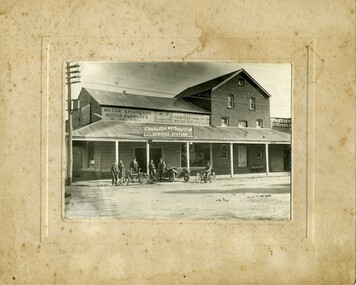
Photograph, Charlton Motors Pty Ltd Service Station c. 1918
Charlton Motors Pty Ltd Service Station, corner of High & Armstrong Streets. Motor engineers, motor supplies of all kinds. Agents for Goodyear and Dunlop tyres, Buick cars, Indian motorcycles. Massey Harris Farm Implements c. 1918. Former Malcolm's steam operated Flour Mill 1876 - 1911. Group of six men, five standing, one on a motor bike. Car across footpath. Wischers written on building next door.Black & white photograph, mounted, unframed. Group of six men, five standing, one on a motor bike. Car across footpath. Sign on building reads "Charlton Motors Pty Ltd Service Station". Advertising for Dunlop & Goodyear Tyres, Buick and Indian Motorcycles. The words Massey and Wischers are written on the building next door.charlton motors, service station, high st charlton, malcolm's flour mill, wischers, massey harris -
 Sunshine and District Historical Society Incorporated
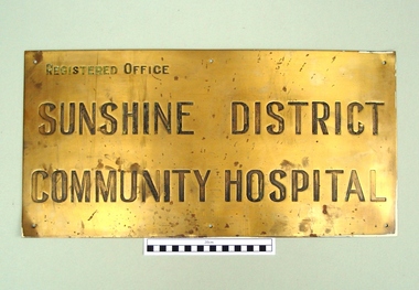
Registration Plate, SUNSHINE & DISTRICT COMMUNITY HOSPITAL
This brass registration plate was once attached to the former Sunshine District Community Hospital in King Edward Avenue, Albion, 3020. The hospital, under several names, served the local community since the 1920's. It became the Sunshine District Community Hospital in 1946 and was closed in 1989. The building was demolished and replaced by residential units. The plate was preserved by Carol Duvall a long serving nurse, who about 20 years later donated it to the Sunshine and District Historical Society.This brass plate is a rare physical relic of what was once the main hospital serving the Sunshine area, and in which many local babies were born.Tarnished brass plate with indented or carved lettering finished in black paint. The black paint is showing signs of deterioration. The plate has six holes for attaching it to a wall, and two of the corners have been bent probably during the removal of the plate. There is also a small amount of paint contamination on the edges.REGISTERED OFFICE / SUNSHINE DISTRICT COMMUNITY HOSPITALbrass plate, registered office, sunshine district community hospital, king edward avenue -
 Hume City Civic Collection
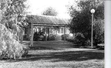
Photograph, Shire of Bulla Offices, 1966
Before the Shire of Bulla built permanent offices in Macedon Street, the council used to meet in the Memorial Hall and had rooms there to conduct regular business. Some cottages were demolished to build the new offices which were completed and opened in 1966. Over the years as the shire's population increased, further additions were added. After Sunbury became part of Hume City Council, the former council building was occupied by Wester Water and Vic Roads.Apart from the former Shire of Bulla Roads Board office built in Sunbury in the 1860s, the 1966 building is the first council building to be built in Sunbury.A black and white photograph of a single storey office building and the surrounding garden. There is a light pole in the foreground.shire of bulla, council offices -
 Kew Historical Society Inc
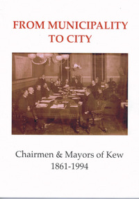
Book, From Municipality to City : Chairmen & Mayors of Kew 1861-1994, 2019
From Municipality to City: Chairmen & Mayors of Kew 1861-1994 is the result of a collaborative history project completed by members of the Kew Historical Society. Th text includes a contextualised series of illustrated biographical and autobiographical profiles of the former civic leaders of Kew. The profiles explore the political, social, cultural and economic history of Kew from the earliest years of European settlement to the amalgamation of Kew into the City of Boroondara in 1994.110 pages : illustrations, portraits ; 29 cm.non-fictionFrom Municipality to City: Chairmen & Mayors of Kew 1861-1994 is the result of a collaborative history project completed by members of the Kew Historical Society. Th text includes a contextualised series of illustrated biographical and autobiographical profiles of the former civic leaders of Kew. The profiles explore the political, social, cultural and economic history of Kew from the earliest years of European settlement to the amalgamation of Kew into the City of Boroondara in 1994.kew (vic.). council -- history, mayors -- victoria -- kew -- biography, kew (vic.) -- history -
 Kew Historical Society Inc
Photograph - 'Southesk' (formerly 'Ordsall'), Cotham Road, 1920s
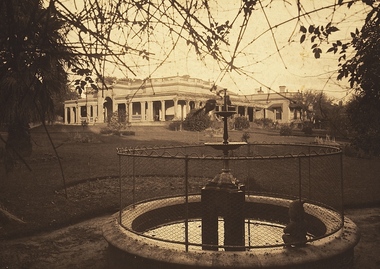
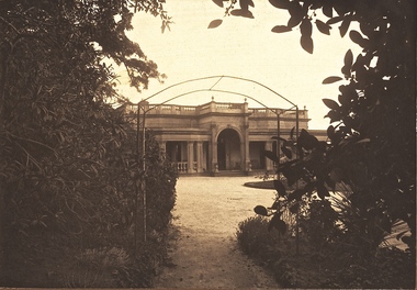
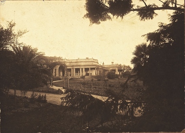
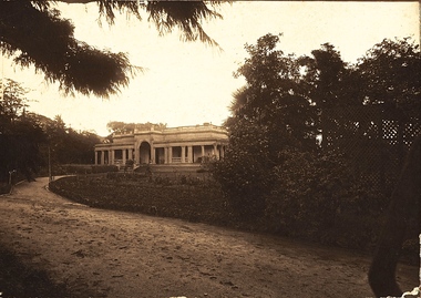
Ordsall was originally built for John Halfey, second Chairman of Kew, and sold after his death to the Carnegie family who renamed it ‘South Esk'. The Carnegie family mounted a defence of their property when the City of Kew sought to compulsorily acquire the site for a new town hall in the 1930s. The house and land were later acquired by Council in 1947 and demolished in 1970. The present Kew Library and the former Council Offices (now owned by Trinity Grammar) are located on the site.One of the earliest photographs of 'Southesk' and its gardens. The house was of statewide significance because of its historical association with John Halfey. It was artistically significant due to its elaborate interiors, decorated by Cullis Hill & Co in the 1880s. Sepia photograph mounted on brown card of "Southesk' (formerly known as 'Ordsall'). The single-storey Italianate facade of the house can be seen surrounded by an extensive garden. The point-of-view of the camera is from Cotham Road.john halfey, david carnegie, southesk - south esk - ordsall -
 Kew Historical Society Inc
Photograph - 'Southesk' (formerly 'Ordsall'), Cotham Road, 1920s
Ordsall was originally built for John Halfey, second Chairman of Kew, and sold after his death to the Carnegie family who renamed it ‘South Esk'. The Carnegie family mounted a defence of their property when the City of Kew sought to compulsorily acquire it as the site for a new town hall in the 1930s. The house and land were later acquired by Council in 1947 and demolished in 1970. The present Kew Library and the former Council Offices (now owned by Trinity Grammar) are located on the site.One of the earliest photographs of 'Southesk' and its gardens. The house was of statewide significance because of its historical association with John Halfey. It was artistically significant due to its elaborate interiors, decorated by Cullis Hill & Co in the 1880s. Sepia photograph mounted on brown card of "Southesk' (formerly known as 'Ordsall'). The single-storey Italianate facade of the house can be seen surrounded by an extensive garden. The point-of-view of the camera is from Cotham Road.john halfey, david carnegie, southesk - south esk - ordsall -
 Kew Historical Society Inc
Photograph - 'Southesk' (formerly 'Ordsall'), Cotham Road, 1920s
Ordsall was originally built for John Halfey, second Chairman of Kew, and sold after his death to the Carnegie family who renamed it ‘South Esk'. The Carnegie family mounted a defence of their property when the City of Kew sought to compulsorily acquire it as the site for a new town hall in the 1930s. The house and land was later acquired by Council in 1947 and demolished in 1970. The present Kew Library and the former Council Offices (now owned by Trinity Grammar) are located on the site.One of the earliest photographs of 'Southesk' and its gardens. The house was of statewide significance because of its historical association with John Halfey. It was artistically significant due to its elaborate interiors, decorated by Cullis Hill & Co in the 1880s. Sepia photograph mounted on brown card of "Southesk' (formerly known as 'Ordsall'). The single-storey Italianate facade of the house can be seen surrounded by an extensive garden. The point-of-view of the camera is from Cotham Road.john halfey, david carnegie, southesk - south esk - ordsall -
 Kew Historical Society Inc
Photograph - 'Southesk' (formerly 'Ordsall'), Cotham Road, 1920s
Ordsall was originally built for John Halfey, second Chairman of Kew, and sold after his death to the Carnegie family who renamed it ‘South Esk'. The Carnegie family mounted a defence of their property when the City of Kew sought to compulsorily acquire it as the site for a new town hall in the 1930s. The house and land were later acquired by Council in 1947 and demolished in 1970. The present Kew Library and the former Council Offices (now owned by Trinity Grammar) are located on the site.One of the earliest photographs of 'Southesk' and its gardens. The house was of statewide significance because of its historical association with John Halfey. It was artistically significant due to its elaborate interiors, decorated by Cullis Hill & Co in the 1880s. Sepia photograph mounted on brown card of "Southesk' (formerly known as 'Ordsall'). The single-storey Italianate facade of the house can be seen surrounded by an extensive garden. The point-of-view of the camera is from Cotham Road.david carnegie, john halfey, southesk - south esk - ordsall -
Kew Historical Society Inc
Flyer - 60 Pakington Street, Kew
Subdivision plans and real estate flyers/brochures reveal a number of aspects of urban development and history. The Kew Historical Society's collection of these plans, as well as advertisements extracted from magazines, cover key aspects of community development and architectural history of Kew and Kew Eat as well as surrounding suburbs. While most of the plans in the collection were gifted to the Society by the former City of Kew, a number of other plans and advertisements have been donated by individuals, of which this is an example. Single page illustrated flyer, advertising 60 Pakington Street, Kew for sale. Annotation in pen and ink at right.neville collection, 60 pakington street -- kew (vic.), real estate advertisements -- kew (vic.) -
Kew Historical Society Inc
Flyer - 45 Pakington Street, Kew
Subdivision plans and real estate flyers/brochures reveal a number of aspects of urban development and history. The Kew Historical Society's collection of these plans, as well as advertisements extracted from magazines, cover key aspects of community development and architectural history of Kew and Kew Eat as well as surrounding suburbs. While most of the plans in the collection were gifted to the Society by the former City of Kew, a number of other plans and advertisements have been donated by individuals, of which this is an example.Single page illustrated real estate flyer advertising 45 Pakington Street, Kew for sale by auction. Annotation in pen and ink at rightpeter neville, real estate advertisements -- kew (vic.), 45 pakington street -- kew (vic.) -
Kew Historical Society Inc
Plan - Tramway Estate, Camberwell North, 1937
Subdivision plans and real estate flyers/brochures reveal a number of aspects of urban development and history. The Kew Historical Society's collection of these plans, as well as advertisements extracted from magazines, cover key aspects of community development and architectural history of Kew and Kew Eat as well as surrounding suburbs. While most of the plans in the collection were gifted to the Society by the former City of Kew, a number of other plans and advertisements have been donated by individuals, of which this is an example.Single page subdivision plan listing properties for sale in the Tramways Estate, Camberwell North. The large estate was bounded by Doncaster Road, Burke Road, Marwan Avenue, Maud Street, Severn Street, and extended over Glass's Creek at Mayland's Avenue. Within the plan, lots 3 to 342 are listed as lots. The plan includes annotations in ink indicating the prices realised by a number of lots. A key explains that lots with an 'H' represent a house, whereas the 37 shaded lots represent those being offered by this agent. subdivision plans -- camberwell (vic.), tramways estate -
Kew Historical Society Inc
Plan - Subdivisional Sale of 11 Villa Sites, East Kew, 1939
Subdivision plans and real estate flyers/brochures reveal a number of aspects of urban development and history. The Kew Historical Society's collection of these plans, as well as advertisements extracted from magazines, cover key aspects of community development and architectural history of Kew and Kew Eat as well as surrounding suburbs. While most of the plans in the collection were gifted to the Society by the former City of Kew, a number of other plans and advertisements have been donated by individuals, of which this is an example.Single page residential subdivision plan advertising house lots for sale, in what was then designated as East Kew but is now Kew, in the following streets: Burke Road, Enfield Street. The flyer includes a smaller locality plan at right. Information on the flyer indicates that the land was previously owned by the Melbourne & Metropolitan Tramways Board.subdivision plans -- kew (vic.), enfield street -- kew (vic.), burke road -- kew (vic.) -
Kew Historical Society Inc
Plan - Camberwell Panorama Estate, 1923
Subdivision plans and real estate flyers/brochures reveal a number of aspects of urban development and history. The Kew Historical Society's collection of these plans, as well as advertisements extracted from magazines, cover key aspects of community development and architectural history of Kew and Kew Eat as well as surrounding suburbs. While most of the plans in the collection were gifted to the Society by the former City of Kew, a number of other plans and advertisements have been donated by individuals, of which this is an example.Promotional brochure for the Camberwell Panorama Estate. The four page bifold handout advertises 216 home sites bounded by Bulleen Road, The Nook, Fortuna Avenue, and Doncaster Road. Other streets in the subdivision include: Sunburst Avenue, The Moor, and Macedon Avenue. The brochure has been damaged at some time in the past and so masking tape obscures the tram on page 1. Page 2 includes the plan of the subdivision, page 3 information about the site and a locality plan, while page 4 includes photographs and terms of sale. subdivision plans -- balwyn north (vic.), camberwell panorama estate -
Kew Historical Society Inc
Plan - Saxonwood Estate, Doncaster [East]
Subdivision plans and real estate flyers/brochures reveal a number of aspects of urban development and history. The Kew Historical Society's collection of these plans, as well as advertisements extracted from magazines, cover key aspects of community development and architectural history of Kew and Kew Eat as well as surrounding suburbs. While most of the plans in the collection were gifted to the Society by the former City of Kew, a number of other plans and advertisements have been donated by individuals, of which this is an example.Undated, multi-page subdivision plan advertising lots for sale bounded by Blackburn Road, George Street, Windermere Avenue, and Saxonwood Drive in what is currently Doncaster East. Other streets in the subdivision include: Mowbray Court, Stafford Court, Rugby Court, and Robin Hood Court. The front page includes a Birdseye view of the estate which identifies existing and projected civic amenities, as well as the estate's relationship to surrounding suburbs and the city centre. Red crosses on the detailed plan of lots on page two indicate those that have been sold. The final page includes a locality plan. saxonwood estate -- doncaster east (vic.), subdivision plans -- doncaster east (vic.) -
Kew Historical Society Inc
Plan - Charteris Estate, Ivanhoe [East], 1927
Subdivision plans and real estate flyers/brochures reveal a number of aspects of urban development and history. The Kew Historical Society's collection of these plans, as well as advertisements extracted from magazines, cover key aspects of community development and architectural history of Kew and Kew Eat as well as surrounding suburbs. While most of the plans in the collection were gifted to the Society by the former City of Kew, a number of other plans and advertisements have been donated by individuals, of which this is an example.Original 4-page bifold handout advertising 43 residential lots for sale in the Charteris Estate subdivision in Ivanhoe [now classified as Ivanhoe East]. This brochure was created to sell the third section of the estate which it labels as 'The Most Superb Section'. Streets within the subdivision include: Burke Road North, McArthur Road, Castella Street, and the Government Boulevard. In addition to the overall plan spread across pages 2 and 3, each page includes a number of interesting photographs including: a number of the new Burke Road Bridge, a sports ground, Hoyts Picture Theatre in Ivanhoe, a croquet ground, and Ivanhoe shopping centre [named Motor Cross Junction].charteris estate - east ivanhoe (vic), subdivision plans -- ivanhoe east (vic.), d.c. mcarthur, charterisville -
Kew Historical Society Inc
Plan - Pointed Firs Estate, Camberwell North, 1936
Subdivision plans and real estate flyers/brochures reveal a number of aspects of urban development and history. The Kew Historical Society's collection of these plans, as well as advertisements extracted from magazines, cover key aspects of community development and architectural history of Kew and Kew Eat as well as surrounding suburbs. While most of the plans in the collection were gifted to the Society by the former City of Kew, a number of other plans and advertisements have been donated by individuals, of which this is an example.Original multi-page sales brochure of the Pointed Firs Estate, advertised as located in Camberwell North, but now in Balwyn North. The 4-page bifold brochure includes promotional material as well as a detailed plan of the 28 lots for sale, a photograph of the locality with the plan overlaying it, as well as aerial photos and street views. The estate included lots in Doncaster Road, Thackeray Street, Houghton Street, an dMaud Street. pointed firs estate -- balwyn north, subdivisions -- balwyn north (vic.) -
Kew Historical Society Inc
Plan - Willsmere Park Estate, Kew, 1926
Subdivision plans and real estate flyers/brochures reveal a number of aspects of urban development and history. The Kew Historical Society's collection of these plans, as well as advertisements extracted from magazines, cover key aspects of community development and architectural history of Kew and Kew Eat as well as surrounding suburbs. While most of the plans in the collection were gifted to the Society by the former City of Kew, a number of other plans and advertisements have been donated by individuals, of which this is an example.Original 4-page, bifold subdivision plan of the Willsmere Park Estate, Kew. The 1926 land sale advertised '40 superb villa allotments' on the 'Yarra Heights'. Streets within the subdivision included: Willow Grove, Kilby Road, Elm Grove and Belford Road. The double page spread on pages 2 and 3 shows the detailed plan of the 40 lots, surrounded by public parkland [Willsmere Park] and the Kew Golf Links. By the time that this version of the plan was released, only the lots on Willow Grove and Kilby Road remained. willsmere park estate -- kew (vic.), subdivisions - kew (vic.), subdivisions -- kew east (vic.), willsmere park -- kew east (vic.) -
Kew Historical Society Inc
Booklet - Yarraleen Estate, Bulleen, c.1966
Subdivision plans and real estate flyers/brochures reveal a number of aspects of urban development and history. The Kew Historical Society's collection of these plans, as well as advertisements extracted from magazines, cover key aspects of community development and architectural history of Kew and Kew Eat as well as surrounding suburbs. While most of the plans in the collection were gifted to the Society by the former City of Kew, a number of other plans and advertisements have been donated by individuals, of which this is an example.Original 8-page booklet advertising a new residential development in Bulleen entitled 'Yarraleen'. The glossy multi-colour brochure includes historic and contemporary photographs of the Yarra Valley, graphic designs of potential residential development, photographs of key facilities (Marcellin College, Golf links, local swimming holes, the Beaver Swim School, Carey Grammar School Oval and grandstand, shopping strips, and farmland).subdivisions -- bulleen (vic.), yarraleen estate -
Kew Historical Society Inc
Plan - 30 Choice Home Sites in Kilby Road, Meldrum Street and Fairway Drive, 1965
Subdivision plans and real estate flyers/brochures reveal a number of aspects of urban development and history. The Kew Historical Society's collection of these plans, as well as advertisements extracted from magazines, cover key aspects of community development and architectural history of Kew and Kew Eat as well as surrounding suburbs. While most of the plans in the collection were gifted to the Society by the former City of Kew, a number of other plans and advertisements have been donated by individuals, of which this is an example.Original 4-page, bifold brochure, one of two in the collection, of home sites created following the creation of the Eastern Freeway which separated a section of land owned by the Kew Golf Club from the main course. The new estate featured 30 lots in Meldrum Street, Kilby Road and Fairway Drive. subdivisions -- kew east (vic.), subdivisions -- kew (vic.), kew golf club -
Kew Historical Society Inc
Plan - 30 Choice Home Sites in Kilby Road, Meldrum Street and Fairway Drive, 1965
Subdivision plans and real estate flyers/brochures reveal a number of aspects of urban development and history. The Kew Historical Society's collection of these plans, as well as advertisements extracted from magazines, cover key aspects of community development and architectural history of Kew and Kew Eat as well as surrounding suburbs. While most of the plans in the collection were gifted to the Society by the former City of Kew, a number of other plans and advertisements have been donated by individuals, of which this is an example.Original 4-page, bifold brochure, one of two in the collection, of home sites created following the creation of the Eastern Freeway which separated a section of land owned by the Kew Golf Club from the main course. The new estate featured 30 lots in Meldrum Street, Kilby Road and Fairway Drive.subdivisions -- kew east (vic.), subdivisions -- kew (vic.), kew golf club -
Kew Historical Society Inc
Plan - Burke Road Junction Estate, East Kew, 1940
Subdivision plans and real estate flyers/brochures reveal a number of aspects of urban development and history. The Kew Historical Society's collection of these plans, as well as advertisements extracted from magazines, cover key aspects of community development and architectural history of Kew and Kew Eat as well as surrounding suburbs. While most of the plans in the collection were gifted to the Society by the former City of Kew, a number of other plans and advertisements have been donated by individuals, of which this is an example.Original 4-page bifold brochure advertising the Burke Road Junction Estate in Kew East. Advertised for sale in 1940, the estate comprised 16 'Central Allotments' fronting High Street, Kilby Road, and Glass Street. Pages 1 & 4, the front and back covers, includes a panoramic photograph of the junction which features a number of shops still extant, but also with buildings long demolished and redeveloped. These include the petrol station and the dairy on the southeast and southwest corners of Burke Road and High Street/Doncaster Road. The dairy includes a statue of a cow on its roof. Pages 2 & 3 include a detailed plan of the estate. subdivisions -- kew east (vic.), burke road junction estate -
 Kew Historical Society Inc
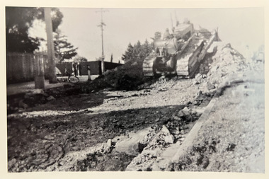
Photograph - Road-making, Studley Park Road, c. 1960
Tom Bentley (1912-1993) was born in Lancashire (UK). From circa 1951, he was the Overseer/Superintendent of Outdoor Works for Kew City Council. Until his retirement in the 1970s, he was based at the Kew Council Depot, located in the former MTB Horse Tram Depot on the corner of Disraeli and High Streets, Kew. Accompanying the set of twelve photographs is a 12-page illustrated biography of the Bentley and Plumridge families, separately kept in the 'Bentley' subject file.Duplicate black and white positive print photograph of road works in Studley Park Road, Kew, carried out under the supervision of Tom Bentley, Overseer/Superintendent of Outdoor Works for the City of Kew. The location at which the photograph was taken is believed, by the donor, to be in the vicinity of Tara Hall (dem. 1960).city of kew, public works, road-making, studley park road, tom bentley -
 Kew Historical Society Inc
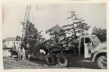
Photograph - Loading a palm tree from Tara Hall, Studley Park Road, c. 1960
Tom Bentley (1912-1993) was born in Lancashire (UK). From circa 1951, he was the Overseer/Superintendent of Outdoor Works for Kew City Council. Until his retirement in the 1970s, he was based at the Kew Council Depot, located in the former MTB Horse Tram Depot on the corner of Disraeli and High Streets, Kew. Accompanying the set of twelve photographs is a 12-page illustrated biography of the Bentley and Plumridge families, separately kept in the 'Bentley' subject file.Duplicate black and white positive print photograph of public works in Studley Park Road, Kew, carried out under the supervision of Tom Bentley, Overseer/Superintendent of Outdoor Works for the City of Kew. The location at which the photograph was taken is believed, by the donor, to be in the vicinity of Tara Hall (dem. 1960). The palm tree on the back of the Council vehicle was believed to have been taken by Council from Tara Hall and relocated to the Alexandra Gardens.city of kew, public works, studley park road, tom bentley, tara hall