Showing 11471 items matching " maps"
-
 Warrnambool and District Historical Society Inc.
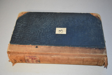
Letter Book 3, 1901 - 1908, 1900
This letter book has letters, plans and maps and dates from 1901 to 1908. It came from the office of John William Crawley, Junior, an engineer, architect and surveyor in private practice in Warrnambool and also the engineer for the Shire of Warrnambool from 1895 to 1935. His father, brother and son were also engineers and worked in that capacity or as the Shire Secretary for the Shire of Warrnambool, with the Crawley family recording a total of 132 years of service to the Shire. The letter book was passed on to John Crawley’s son, Rolf, engineer for the Shire of Warrnambool from 1935 to 1968. The letter book then came into the possession of Michael Hand who took over the private surveying business of Rolf Crawley in Warrnambool. The Warrnambool and District Historical Society has acquired the letter book, one of several Crawley ledgers, from the Michael Hand estate. The Shire of Warrnambool existed from 1863 to 1994. This letter book is of considerable significance as it contains maps, plans and letters produced by John William Crawley Junior, the engineer for the Shire of Warrnambool for 40 years. It will be very useful for research. This is a hard cover letter book of 717 pages. It has a black cover with brown leather binding on the cover edges and spine. The leather is worn away in places. The letter book contains an alphabetical index, handwritten letters, sketch plans and maps. There is a mauve stamp on the inside front cover. ‘3’ ‘Letter Book 1901 to 1908’ ‘Letter Book J.Wm. Crawley’ ‘Rolf L. Crawley, Civil Engineer, Drainage and Water Supply Engineer, Licensed Surveyor, Registered Architect, Warrnambool’ john william crawley junior, warrnambool, rolf crawley, warrnambool, history of warrnambool -
 Warrnambool and District Historical Society Inc.
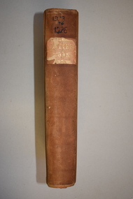
Letter book 14, 1923
This letter book contains letters, sketch maps and plans and dates from 1923 to 1926. It came from the office of John William Crawley, Junior, an engineer, surveyor and architect in private practice in Warrnambool and also the engineer for the Shire of Warrnambool from 1895 to 1935. His father, brother and son were also engineers, working in that capacity or as the Shire Secretary for the Shire of Warrnambool, with the Crawley family recording a total of 132 years of service to the Shire. The Shire of Warrnambool existed from 1863 to 1994. This letter book was passed on to John Crawley’s son, Rolf, the engineer for the Shire of Warrnambool from 1935 to 1968. It then came into the possession of Michael Hand who took over the private surveying business of Rolf Crawley in Warrnambool. The Warrnambool and District Historical Society acquired the letter book, along with several other Crawley ledgers, from the estate of Michael Hand.This letter book is of considerable significance as it contains letters, maps and plans drawn up by John William Crawley, an engineer and surveyor in private practice in Warrnambool and the engineer for the Shire of Warrnambool for 40 years. It will be useful for researchers. This is a brown hard cover letter book of 1010 pages, with brown binding on the corners of the cover and on the spine. The cover is cuffed and torn. There is gold lettering on the spine. The book contains handwritten letters, maps and plans and an alphabetical index at the front, The pages are water-stained. There is a mauve stamp on the first page.‘Letter Book 1923 to 1926’ ‘J. Wm. Crawley Shire Hall Warrnambool (Private)’ ‘Rolf L. Crawley Civil Engineer, Drainage and Water Supply Engineer, Licensed Surveyor, Registered Architect, Warrnambool’ john william crawley junior, warrnambool, rolf crawley, warrnambool, shire of warrnambool -
 Kiewa Valley Historical Society
Maps of Victoria
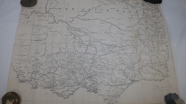
Three maps: copies from the 19th century. 1. Handwritten 'Dept of Lands & Survey 1876'. 2. Map of the Ovens & Murray District, Victoria with handwritten 'F.H. Hiscock & Co's, New Victoria Countries Atlas 1874'. 3. Map of the Murray and Gipps Land Distr' with handwritten: "Baillieu's County Atlas of Victoria 1866'.maps of victoria, 19th century, oven and murray district of victoria -
 Bendigo Military Museum
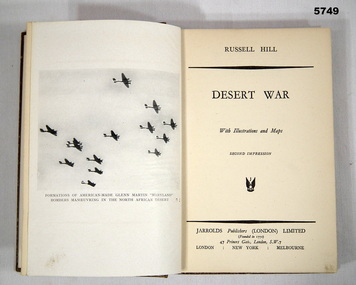
Book - BOOK, BATTLE CAMPAIGN WW2, Russell Hill, "Desert War", 1942
Book - Account of Battle campaign Tobruk, WW2.Hard cover book. Cover - cardboard, brown colour buckram cover with white print on spine (illegible). 140 pages - cut, plain, off white paper. Illustrated with black and white photographs and maps. End papers - illustrated sepia tones - map of Libya/Egypt (front) - map of Tobruk and battle. Campaign books.Front end paper - handwritten blue pen - "15-"books, military history, ww2, campaigns -
 Bendigo Historical Society Inc.
Map - JOHN WILLIAMS COLLECTION: PHOTO-MAP OF BENDIGO, 2007
Map, Photo-map of Bendigo,Australian Government Department of Defence,prepared and published by the Defence Imagery and Geospatial Organisation 2007.Copyright Commonwealth of Australia 2007.Australia Photomap 1:15 000. Edition 2-DIGO. WGS84.Grid 1000 metre UTM Zone 55. (number 407 in map cupboard 1)Defence Imagery & Geospatial Organisationmap, bendigo, city streets -
 Bendigo Historical Society Inc.
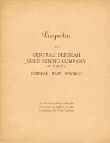
Document - MCCOLL, RANKIN AND STANISTREET COLLECTION: PROSPECTUS OF CENTRAL DEBRORAH GOLD MINING CO NL, 1939
McColl Rankin & Stanistreet, Prospectus of Central Deborah Gold Mining Company NL. Item date: June 1939. Book soft cover 3 copies. A/ Application and map intact. Excellent condition. B/ Map and Application intact, fold crease down centre. Good condition. C/ No map no Application. Good condition.McColl Rankin & Stanistreetorganization, mining, central deborah gold mining co nl, mccoll rankin & stanistreet, prospectus of central deborah gold mining company nl. june 1939. -
Kew Historical Society Inc
Archive (Sub-series) - Subject File, Kew Historical Society, HODDLE Survey, 1997
Various partiesReference, Research, InformationSecondary Values (KHS Imposed Order)Photocopied correspondence and maps (surveys) relating to surveys ordered by Robert Hoddle, Government Surveyor. Authors of letters and information include Gwen McWilliam and Jack Hackett. Much of the correspondence relates to the site of the ‘Hoddle Tree’, currently located in the Kew Golf Course. Jack Hackett’s original map is contained in the map drawers in the Society’s archive.kew historical society - archives, kew (vic) - history, robert hoddle - surveyor, hoddle tree - kew (vic), jack hackettkew historical society - archives, kew (vic) - history, robert hoddle - surveyor, hoddle tree - kew (vic), jack hackett -
 Bacchus Marsh & District Historical Society
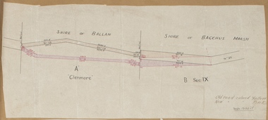
Map, Road plan deviation near Glenmore
This plan shows a proposed deviation in the road near Glenmore. This is likely to have been the Bacchus Marsh to Ballan road. The precise date of the plan has not been established. Proposed deviations to the road near Glenmore appear in reports in the Bacchus Marsh Express newspaper through many decades, especially in the 1870s and 1880s. Glenmore is located 19 kilometers west of Bacchus Marsh.A single page paper map showing a plan for a road deviation near Glenmore Station. Scale 5 chains to 1 inch. Date of production unknown. Circa 1860s-1890s. The map is pasted into a bound volume containing 76 maps or plans in total. High resolution digital image stored on BMDHS computer network. Old road colored Yellow, New road colored Pinkroad plans, road construction, glenmore victoria maps -
 Ringwood and District Historical Society
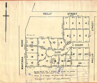
Map, Subdivision Plan Amendment - Bass Court, Heathmont, Victoria - (Undated, Circa 1964)
Printed subdivision maps on light cardboard backing - Map A - 24 residential allotments fronting Wantirna Road, Reilly Street, Phillip Street and Lee Court, Heathmont, with proposed creation of Bass Court and additional subdivision allotments. Map B - Hand-drawn layout of 10 allotments fronting Wantirna Road and Bass Court. -
 Lara RSL Sub Branch
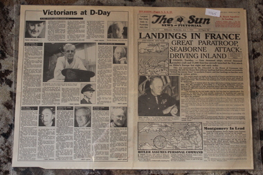
Newspaper - Herald Sun 50th Anniv. Re Print of a Newspaper dated 6/6/1994 Of D-Day 7/6/1944
Herald Sun 50th Anniv. Newspaper dated 6/6/1994 Of D-Day 7/6/1944Newspaper - D-Day Invasion 7/6/1944Herald Sun 50th Anniv. Newspaper dated 6/6/1994 Of D-Day 7/6/1944Landings In France - Hitler Assumes Personal Command - Map The Normandy Invasion D-Day 6/6/1944landings in france - hitler assumes personal command - map the normandy invasion d-day 6/6/1944 -
 Bendigo Historical Society Inc.
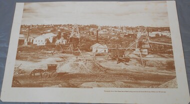
Photograph - Photograph of New Chum Line of Reef
BHS CollectionSepia coloured print of a photograph of the New Chum Line of Reef looking south from the Snobs Hill group of mines. The photo shows several poppet heads and chimneys, bridges and houses. New Chum Line of Reef. includes Victoria Hill possibly the richest spot on the field.On the back a drawing of a poppet head with the words: Bendigo gold project. A small map of Victoria is also printed on the back. bendigo mines, new chum line of reef, mining -
 Victorian Aboriginal Corporation for Languages
Kit, Koorie education kit, 1995
Koorie cultural heritage is introduced in lesson form. For use in schools Prep to Year Eightmaps, b&w photographs, b&w illustrations, cartoons, colour photographs, A4-sized information cardskoorie culture and education, primary school education, koorie history -
Glenelg Shire Council Cultural Collection
Souvenir - Plate - State of Victoria, c. 1984
White, boxed, fine china Westminster plate, State of Victoria, in green with black place names, floral emblem (pink heath) above state. Gold rim. Plate size is 19cm diameterFront: 'State of VICTORIA 150TH ANNIVERSARY' - blue lettering, above map 1984-5 GROWING TOGEHTER' - blue lettering beneath map. Back: Time line of Victoria's first 150 years - in black print. 150th logo Westminster Australia. Makers mark -
Bendigo Historical Society Inc.
Map - CAMPBELL COLLECTION: BENDIGO AND DISTRICT MAPS, 12-2-29
Map. Axedale, Parish of Ellesmere and Axedale, Total area 4156 acres, Prepared in W.P.B. from A. and P. Plans by W.J. Galbraith 12-2-29. (number 383 in map cupboard 1)W.J.Galbraithmap, bendigo, agricultural lands -
Bendigo Historical Society Inc.
Map - CAMPBELL COLLECTION: BENDIGO AND DISTRICT MAPS, 15-2-29
Map. Nerring, Parish of Nerring, scale 20 chains to 1 inch. Prepared in W.P.B. from A. and P. Plans by W.J. Galbraith. 15-2-29. (number 379 in map cupboard 1)W.J.Galbraithmap, bendigo, agricultural lands -
Bendigo Historical Society Inc.
Map - CAMPBELL COLLECTION: BENDIGO AND DISTRICT MAPS, 15-2-29
Map. Nerring, Parish of Nerring, scale 20 chains to 1 inch. Prepared in W.J.B. from A and B plans by W.J. Galbraith 15-2-29. (number 356 in map cupboard 1)W.J.Galbraithmap, bendigo, parish plan -
 Bendigo Historical Society Inc.
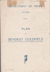
Map - BENDIGO GOLDFIELDS MAP
Map of the Bendigo Goldfield, showing reef lines, mines and significant geographical features such as Monument Hill, Quartz Hill and Diamond Hill. On the back of map 'Department of Mines, Victoria. Plan of Bendigo Goldfield.bendigo, mining, bendigo goldfields -
 Bendigo Historical Society Inc.
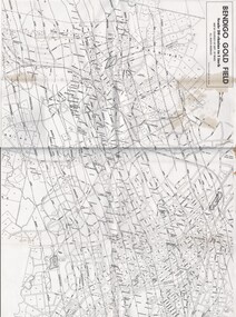
Map - MAP OF BENDIGO GOLDFIELDS
Map. Copy of a map of the Bendigo Goldfields issued by the Dept. of Mines showing lines of reef, mines and streets. Scale 20 chains to 1 inch. Printed by Cambridge Press, Bendigo. Date unknownmap, bendigo, goldfields, map, goldfields, department of mines -
 Bendigo Historical Society Inc.
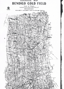
Map - LONG GULLY HISTORY GROUP COLLECTION: GEOLOGICAL MAP - BENDIGO GOLD FIELD
Copy of a Geological Map of the Bendigo Gold Field. Map shows Lines of Reef, Anticlines, Synclines, Shafts, Alluvial Contours Gullies and some street names. Copy is hard to read. There are two pages.bendigo, history, long gully history group, the long gully history group - geological map - bendigo gold field, mines department, h herman, lightning hill line, hustlers line, derby line, paddy's gully line, garden gully line, deborah line, sheepshead line, new chum line, nell gwynne line, british and foreign line, napoleon line, carshalton line, thistle line, christmas line, lancashire line -
Tatura Irrigation & Wartime Camps Museum
Swagger Stick, 1944-45
Made by a German POW about 1944-45 and given to WO11 R. E. O'Hara. R. E. O'Hara, father of the donor, was a WO11 in the POW camp. He left Tatura at the end of the war when he was posted to Manus Island for the war crimes trials against the Japanese. He continued in the Army until 1952. WO11 R. E. O'Hara VX5293. His rank on discharge was WO1 Dark brown wooden swagger stick with large knob on one end which depicts an inlaid map of Australia in a light colour with a brass crown insignia (bade of rank) inside the map of Australiawo11 r. e. o'hara., swagger stick -
 Melbourne Tram Museum
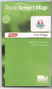
Document, Ministry of Transport, "Travel Smart Map - Port Phillip", 2010
Gives extensive details of walking cycling Public Transport in Port Phillip. Printed 2010. Yields information about Port Phillip transport and other services in 2010Map - pocket - 28 fold - showing walking, cycling and public transport in the City of Port Phillip, using a Melway Map base along with public transport information, Metcard, cycling and walking groups.tramways, melbourne, tram services, bus services, railways, port phillip, cyclists -
 Bendigo Historical Society Inc.
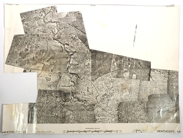
Map - FRED COWIE COLLECTION: AERIAL MAPS OF HEATHCOTE/EPPALOCK
Map, Heathcote A3, Aerial Survey of Victoria, Photo-map prepared by Department of Crown Lands.Campaspe River , Wild Duck Creek, Knowsley, Eppalock Weir.Fred Cowie,46 McIvor Rd ,Bendigo.map, heathcote, fred cowie -
 Ringwood and District Historical Society
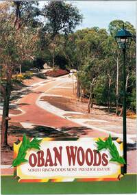
Document - Land Sale Folder, Oban Woods Subdivision, Ringwood North, Vic., - circa 1997
Folder containing multi-fold colour pamphlet advertising Lots 6 to 12 of Oban Woods Estate with location map and summary of subdivision features. A4 size attachments include subdivision layout of Lots 2 to 25 with summary of property sizes and undated indications of whether sold or still available at the time, with price where known. Dates not documented however early sales within the development took place around 1997.Estate plan includes Oban Woods (thoroughfare) and Chifley Parade. Location map of area shows development site of Oban Woods Estate off Oban Road and Kubis Drive, Ringwood North. Agents - R.E. Appleby Ringwood Pty Ltd., 170 Warrandyte Road Ringwood North 3134, Telephone 9876 4222, Fax 9876 4209. -
 Warrnambool and District Historical Society Inc.
Booklet - Booklet Collection: City of Warrnambool Tourist Guides, Collett, Bain and Gaspar, Warrnambool
This is a collection of sixteen tourist guides dating from the mid 1970's to 2013. These contain listings of businesses, accommodation, eateries and events in Warrnambool and district. They also include maps of Warrnambool and surrounds, advertising and photographs of various attractions. While mainly covering Warrnambool a small number of the guides cover the South West Region. These directories have mainly been published by the Warrnambool City Council and are a selection of the types of information provided to visitors at the Tourist information centre during this time period.These tourist guides give snapshots of the City of Warrnambool for the years covered and will be useful for research.[.1] An 8 page paper booklet with black printing and a black & white photo of the pond at the Botanical Gardens on the front cover. [.2] two photocopied A4 black and white pages from the book "On the Trail" K Winser 1956 (Main Roads of Australia) [.3] A trifold colour brochure with a stylised map of the coast on the yellow and blue front cover. The inside has stylised colour drawings on Warrnambool attractions. The rear cover has coloured photographs of bush, Liebig Street and Fletcher Jones gardens [.4] A trifold black and white brochure with a black line drawing of a whale on the front cover. [.5] A trifold white card with mauve printing. The front cover has a line drawing of the former Timor Street post office and a map of businesses and landmarks in Timor Street. The reverse side contains a brief history of Warrnambool. [.6] A 98 page stapled booklet with a foreword by Vanda Savill. There are 4 pages of coloured photographs. The remainder are black and white photographs. The front cover is purple with white writing in the lower third. There is an outline of the coast and five colour photographs of district attractions. The inside middle page has a map of the Western wonderland region. The content covers towns in this area. Content relating to Warrnambool is in the last six pages. [.7] Twelve loose photocopied black and white pages. The front cover has the Warrnambool Premier Town 1988-1991 logo and a photo of a Southern Right Whale and calf. The bottom right hand corner has a Standard Warrnambool logo. [.8] 44 page booklet printed with blue ink. The staples have been removed. The glossy front cover has blue printing with a coloured photo of Flagstaff Hill Maritime Village pond. The centre pages has a fold out map of the City of Warrnambool. The rear cover has photos of The Twelve Apostles and Hopkins Falls. [.9] 4 loose photocopied pages with Warrnambool Library and Corangamite Regional Library Service Warrnambool City Library black ink stamps. The front page line drawing illustrations of Warrnambool attractions [.10] A single sheet of glossy white paper folded in half to make four pages. The front page has a Warrnambool premier town logo 1979-1982 and blue printing and a visitor survey. [.11] A conference pack of light card folded to make a pocket containing three brochures, a shipwreck coast tourist directory and a Australian Heritage Parks Association conference program dated 24 to 27 May 1992. The front cover of the pack has green writing over a stylised upward arrow. There is a City of Warrnambool logo in the top right hand corner and two film strips diagonally across the cover containing photographs of Warrnambool. The rear cover has a coloured Warrnambool Premier Town logo. [.12] A 63 page stapled booklet with coloured photographs of Warrnambool. The front cover has black writing on white background. There is a coloured photograph of Flagstaff Hill in the middle of the cover and a Warrnambool City and Visit Victoria logos on the lower edge. The middle pages has a coloured of the city of Warrnambool with an inset map of Allansford. [.13] A single large sheet of white paper folded in ten to make a brochure. The front cover has black printing. The rear cover has a purple ink stamp for the City of Warrnambool Tourist Information Centre. When folded out the reverse side has a green, grey and white map of the South West Region of Victoria. [.14] A 48 page colour booklet on glossy paper. The front cover has white writing on a blue background and includes photographs of the Twelve Apostles, the Promenade walk, Flagstaff Hill and a southern right whale's tail. The rear cover has photographs of The Twelve apostles, a passenger train from Melbourne passing the Lake Pertobe playground, and a rural scene. There is white writing and a white Warrnambool City logo on a blue background. The centre pages have a stylised green and blue map of the city of Warrnambool. [.15] A 48 page colour booklet on glossy paper. The front cover has white writing over colour photographs of two people at a lookout, Flagstaff Hill, three southern right whales and a child at the Lake Pertobe playground. The lower edge has blue upper case writing on a white background. The rear cover has a colour photograph of the Twelve Apostles. The lower white border on the rear covers has a a blue and green City of Warrnambool logo and blue writing. The centre pages have a stylised green and blue map of the city of Warrnambool. [.16] A 64 page colour booklet on glossy paper. The front cover has black writing on a black background and there is a photograph of a southern right whale's tail. The lower edge has the Warrnambool City and Visit Victoria Logos. The centre pages have maps of Warrnambool and surrounds. [.1] This week in Warrnambool Vol 2 No. 5 Thurs 1st Feb. For the time of your life [.2] Warrnambool Way [.3] Warrnambool The Holiday Host on the South West Coast with compliments City of Warrnambool and Warrnambool Chamber of Commerce [.4] MMI Insurance presents Whales Giants of the Deep Whale Watcher's Logbook Warrnambool [.5] Warrnambool History began in Timor Street [.6] Western Wonderland Tourist Association [.7] A Premier Arrow Tour of Warrnambool Victoria's Premier Town Australia's Southern Right Whale Nursery [.8] Warrnambool The Heart of Victoria's Great Southwest Visitor's Handbook [.9] What to see in Warrnambool Victoria's Premier City 1979-1982 [.10] Win a Free Holiday & $200 Cash in Victoria's Premier Town [.11] Advancing Warrnambool together! [.12] Great Ocean Road Warrnambool Official Visitor Guide [.13] Tourist guide to the South West Region Victoria All it needs is you [.14] Warrnambool visitor guide 2005 the great ocean road experience attractions accommodation entertainment dining [.15] Warrnambool Visitor Guide 2006 the great ocean road experience Attractions Accommodation Entertainment Dining [.16] Official Visitors' Guide Warrnambool Victoria Australia Discover the Great Ocean Road warrnambool, warrnambool tourist guides -
Ringwood and District Historical Society
Pamphlets, Vic Roads, Pamphlets about Ringwood Bypass development, and one map. 1991-96, 1991-1996
Pamphlets about Ringwood Bypass development. Qty 6. With one map. -
 Lara RSL Sub Branch
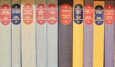
Book, The Memoirs of Field M- Marshal Montgomery Author Montgomery of Alamein K.G, 1960
London, Europe and Dardenelles. Personal recount of boyhood in England to Military service and death.WWII personal recount. Statistics, Maps, Illustrations, Photographs. Letters .An autobiography. " A blessed companion is a book" by Jerrold Inside front pagewwii, whitehall, 8th army, london, el alamein, dardenelles, europe, unity of the west, palestine, germany, russia, high command, german surrender, italy, sicily, normandy, dunkirk, docterine of command, arnhem -
 Ballarat Clarendon College
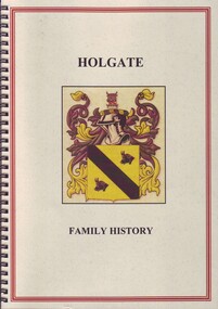
Book, L J Richard Mooney, Origin and history of the Holgate family, 2014
Family history referencing old collegians George Holgate (1891), Stephen Holgate (1895), Harry (1896), Edward (1906), Robert (1908) and Thomas (1911). Spiral bound A4 book; coloured illustrations, maps and graphs; 61p. george holgate, stephen holgate, harry holgate, edward holgate, robert holgate, thomas holgate, world war one, ballarat college -
 Bendigo Military Museum
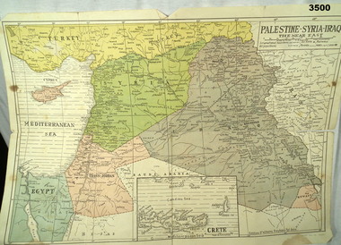
Map - MAP MIDDLE EAST, Dyag Press Ltd
Coloured map of Palestine, Syria, Iraq & Crete, countries involved in the war.documents - maps, military history, middle east -
 Federation University Historical Collection
Map, Eastern Ballarat (c) Retail and Business Guide, 2004
Map of Ballarat East including Brown Hill, Mount Clear and Buninyong.brown hill, mount clear, mount helen, buninyong, university of ballarat -
4th/19th Prince of Wales's Light Horse Regiment Unit History Room
Framed Map, Tallarook, 12/11/1923
Tallarook was a training area of the Regiment1 Inch: 1 Mile map of Tallarook in glass fronted frame