Showing 4840 items matching " road signs"
-
 Pyrenees Shire Council
painting, The Pyrenees from Old Shirley Road by Frank Kunz, 2016
significant as a work of art by local Pyrenees artist, locally significant to the Central Highlands Region of Victoria as a representation of local landscape and/or culturelandscape scene of Pyrenees ranges in two partssigned: F Kunz (lower left) verso: THE PYRENEES FROM OLD SHIRLEY ROAD 2016 verso (affixed): 2018 Beaufort Agricultural Society Pyrenees Shire Council Aquisitive Prize Winner FRANK KUNZ -
 Pyrenees Shire Council
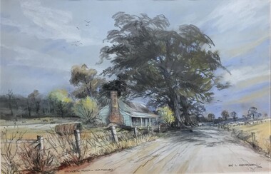
painting, Ian L Anderson, School Road, Waterloo by Ian L Anderson, 1995
significant as a work of art by local Pyrenees artist, locally significant to the Central Highlands Region of Victoria as a representation of local landscape and/or culture pastel drawing of a street scene with old house, trees and unpaved road"Signed: IAN L ANDERSON 95 (lower right) Titled: SCHOOL ROAD - WATERLOO (lower centre) Verso (affixed): ""SCHOOL ROAD - WATERLOO"" PASTEL AND CHARCOAL PENCIL PAINTING by IAN L. ANDERSON 14 MILLAR CRESCENT MT WAVERLEY 3145 signed: Ian Anderson '95 $500" -
 Pyrenees Shire Council
painting, The Firs, Raglan Road, Beaufort by Sue Jarvis, 1993
significant as a work of art by local Pyrenees artist, locally significant to the Central Highlands Region of Victoria as a representation of local landscape and/or culture painting of homestead"Signed: JARVIS Verso: THE FIRS, RAGLAN ROAD, BEAUFORT SUE JARVIS 1993 55 BRANTOME ST GISBORNE 3437 PH 054282674 OR BLACKWOOD LANE STUDIO 24 BLACKWOOD LANE GENBROOKN3738 PH 059 681 567 $525" -
Pyrenees Shire Council
painting, Vivienne Wheeler, Late Afternoon on the Raglan Road Beaufort by Vivienne Wheeler, 1988
significant as a work of art by local Pyrenees artist, locally significant to the Central Highlands Region of Victoria as a representation of local landscape and/or culture "signed: V Wheeler 88 (lower left) verso (affixed): Vivienne Wheeler RMB 696 Bald Hills 3364 Late afternoon on the Raglan Rd, B'fort oil $500 1989 Ripponshire Art Award ""THE FIRS"" V Wheeler" -
 City of Kingston
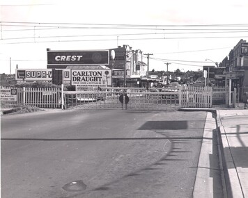
Photograph - Black and white, c. 1960
This image is part of a larger collection of images from the Public Transport Corporation displaying train stations and streetscapes in what is now the City of Kingston.Black and white photograph of crossed level crossing gates at McKinnon railway station. The image also affords a street view which includes the shopping strip where advertising signs abound.Stamped in blue ink on reverse: COPYRIGHT / Public Transport Corporation / For re-ordering photographs / Please quote negative No PR4764 / Enquiries C/- PTC Photographic Unit / Telephone switchboard 619 111mckinnon, railway station, streetscape, shopping strip, suburbs -
 City of Kingston
Photograph - Black and white, c. 1970
This photograph depicts the steel tramway (or tram plate) along Centre Dandenong Road, Cheltenham near the Moorabbin Airport entrance in the 1970's. These tramways played an important role in transportation along Moorabbin's major roads. Heavily laden carts could travel smoothly and safely along the steel plates when the road surfaces were often rutted and hazardous. This surviving section was later moved for road improvements. The area now known as the City of Kingston was a market garden region and the round trip to market could take as long as eight hours on poorly maintained roads. The installation of the steel tramway transformed the arduous journey faced by market gardeners in transporting their produce to market. As there was only a single tramway, the carts often travelled in convoy, enabling drivers to leave piloting to the first cart and having a rest. The rails did not speed the journey to the city, but it smoothed progress immeasurably. Black and white photograph of steel tram plates on Centre Dandenong Road, Cheltenham. The road is sealed. At the top of the image there are trees behind a parked car which is adjacent to a white shelter. There is a large sign stating MOORABBIN AIRPORT above an arrow pointing to the right in the top centre of the image. Handwritten in pencil: A 28 / [indecipherable] 3 / [indecipherable] Handwritten in red ink: A28 / 70%market gardening, infrastructure, transport, steel tramway, industry, moorabbin -
 City of Kingston
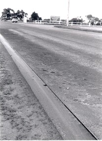
Photograph - Black and white, c. 1950
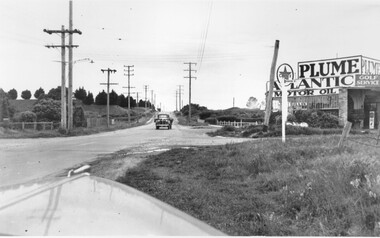
While the road is sealed, there is evidence of potholes that have been filled, and the wide, gravel shoulder has long grass running into the gutter of the nature strip. On the other side of the road, extremely long grass can be seen growing on the side of the road. There is a truck visible on the road, which indicates the rural nature of the Cheltenham community in the 1950s.This image is one of many in the collections that focuses on the railway or roads. The development of roads and the railway was crucial to the ongoing development of the area. Black and white photograph of the intersection of Warrigal and Centre Dandenong roads, Cheltenham. On the left hand side is a small sign warning of a cross roads intersection. Housing and shops line the road.Handwritten in blue ink on reverse: 219 Handwritten in red ink on reverse: 80%cheltenham, roads, suburbs -
 City of Kingston
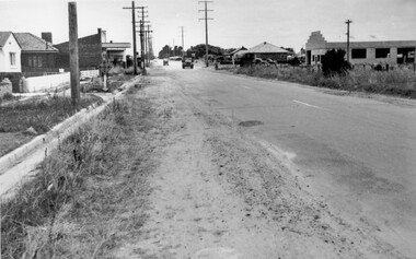
Photograph - Black and white, c. 1950
The intersection of Warrigal Road and Nepean Highway is now a major intersection, serviced by traffic lights. In the 1950s it was a joining of two sealed roads, although covered in gravel, and with wide gravel shoulders. There are no traffic signs and the few houses visible are not set very far back from the road. This image is one of many in the collections that focuses on either roads or the railway. The development of roads and the railway was crucial to the ongoing development of the area.Black and white photograph of the intersection of Warrigal Road and Nepean Highway, Mentone. Handwritten in blue ink on reverse: 218 Handwritten in red ink on reverse: 75%mentone, roads, suburbs -
 City of Kingston
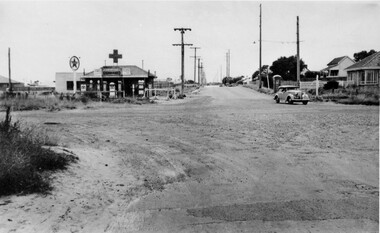
Photograph - Black and white, c. 1950
... with a street sign for Centre Road.... with a street sign for Centre Road. Photograph Black and white ...This image highlights the rural nature of the area during the 1950s where areas that are now major highways and intersections appear like country roads.Black and white photograph of the intersection of Warrigal Road and Centre Road in Oakleigh. There is a truck travelling south toward the camera along Warrigal Road which is a sealed road. On the right hand side is a Caltex petrol station with a street sign for Centre Road.Handwritten in blue ink on reverse: 2191 Handwritten in red ink on reverse: 72%oakleigh, cars, roads, suburbs -
 City of Kingston
Photograph - Black and white, c.1973
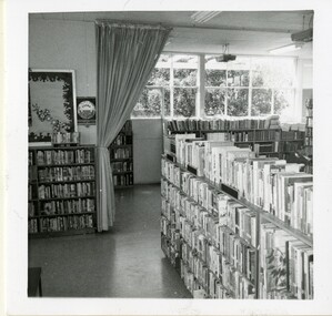
This photograph shows the interior of a library Black and white photograph of a library interior showing several bookshelves full of books. There is a curtain hanging from the ceiling to the rear of the photograph in front of large windows which are letting in light. A small sign to the left of centre reads 'TEENS CORNER'library, libraries -
 City of Kingston
Photograph - Sepia, c.1973
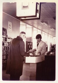
This photograph shows the interior of a library with a staff member serving a patronSepia photograph of a library interior showing two men facing one another across a circulation desk. There is an illuminated sign with the word 'Read' hanging down above them. Bookshelves line the left-hand wall. libraries, customer service -
 City of Kingston
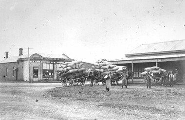
Photograph - Black and white, 1914
Judd's General Store was on the corner of Centre and East Boundary roads in East Bentleigh. This image shows unsealed roads at an intersection with loaded wagons for transporting (or recently transported). The building in the immediate background has a ghost sign which is now illegible. The photograph was apparently taken nine (9) days after the declaration of World War I. Orlando Judd is second from left.Black and white image of four men standing outside in front of three horse drawn wagons loaded with hessian bags. They are standing in front of Judd's General Store which was on the corner of Centre and East Boundary roads, East Bentleigh.White round sticker on reverse with black printed text: 79 Handwritten in red ink on reverse: 60%east bentleigh, horses, horse drawn wagon, commerce -
 City of Kingston
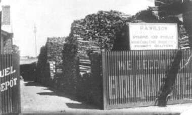
Photograph - Black and white, c. 1910
Percy Wilson's woodyard was on Point Nepean Road, Cheltenham. Wilson was the local wood man and fuel merchant. Black and white image of a wood yard with a corrugated iron fence. Advertising is painted on to the fence, indicating they also sell briquettes. There is a sign on top of the fence including the business name, phone number and that it sells wood, coal, coke, and briquettes.cheltenham, wood, coal, briquettes, commerce, domestic -
 Bass Coast Shire Council - Robert Smith Collection
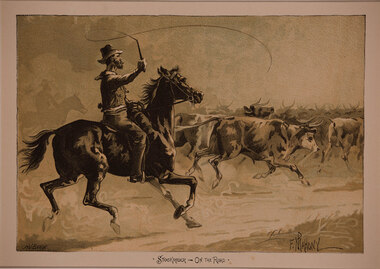
Artwork, other - Stock-rider on the Road, Frank P. Mahony
Colour LithographSigned in image -
 Melbourne Legacy
Letter, Colonel W. Donovan Joynt, V.C
An brief account of the life of Colonel William Joynt VC, written according to the letterhead by Sir Alfred Kemsley, KBE, CMG, who was President of Melbourne Legacy 1932-33. Although the document was undated it was probably written in 1986 for the funeral of Colonel Joynt. (see also Cat. No. 01303). It gives a brief overview of Joynt's life and notes that Kemsley wrote the foreword to Joynt's autobiography, 'Breaking the road for the rest' (Melbourne: Hyland House 1979. ISBN 13: 9780908090129). Joynt also wrote of his war experiences in 'Saving the Channel Ports' (UK: Wren 1975. ISBN 13: 9780858852020).Indication of the high esteem in which Colonel Joynt was held by Melbourne Legacy.2 typed photocopied sheets, one letterhead, black on whiteSigned 'A.Kemsley'donovan joynt, obituary -
 Melbourne Legacy
Photograph, Sale of Harelands renamed Blamey House
From the 1940s Melbourne Legacy ran residences for children of deceased servicemen. In the 1980s it was decided to sell the final property as the requirement for care had dwindled. These photos show the auction day at Blamey House (previously known as Harelands), from the street the auction flag and 'For Sale' sign can be seen. The photos show a large group of people watching the auction names are unknown. The property at 5 Willesmere Rd Kew was formerly known as Harelands. It was renamed Blamey House when the previous Blamey House (at 1267 Burke Road) was sold in late 1970s. It was the third Legacy residence to use the name Blamey House as it was a condition of the donation to keep the name.The sale of Blamey House was a milestone in the residences history and these photos are from the day of the auction.Colour photo x 7 of the auction sale of Blamey House.residences, properties, harelands, blamey house -
 Bendigo Historical Society Inc.
Administrative record - Spring Gully Gold Mining Co. Fryerstown, Minute Book1903 - 1915, 1924 - 1929
The Spring Gully Gold Mining property consists of Gold Mining Lease No. 2986, Castlemaine, of about 21 acres situated on the Emu Reef, in Spring Gully Fryers. There are two shafts, distant about 300 feet from each other. From one of them large quantities of gold were obtained in former years by previous companies. ( Prospectus of the Spring Gully Mining CompanyMaroon hard cover book, brown leather binding on spine and corners, three hundred and eighty pages. Written on spine of book in gold leaf : 'Minute Book'. Handwritten minute entries from 14th September 1903 to 30th August 1915. Affixed to first page, newspaper clipping from the 'Herald' 13/9/05, with information about the Spring Gully Mine Fryerstown. Page eighty-one has two quotes affixed from 'The Yarraville Chlorination and Ore Reduction Works' High Street Yarraville, July 1905, for works associated with pyrites and blanket sand. Page nine, a handwritten letter affixed to minutes, applying for a block of land 250 feet north of main shaft. Signed by J.S. Potter, H. Hancock, G Murray and T. Tumney. 1.Page one hundred and one: three quotes from 'Edwards' Metallurgical Works' Specimen Hill, Bendigo for pyrites and blanket sand. 2.Page one hundred and fifty five: handwritten letter (copy) from A. Schonfelder re shaft work on the mine and mention of tributors 3. Affixed to inside cover: letter from the 'United Shire of Mount Alexander' April 15th. 1907, regarding the reconstruction of the Vaughan bridge over the Loddon River. 'the benefit that the mines in your district derive from the bridge being open for wood waggons and this being the main traffic and this being the principal cause of the bridges present condition'. 4. Prospectus of the Spring Gully Mining Company, Spring Gull, Fryerstown, two page folded document enclosed inside back cover of book. Prospectus incomplete. (10746.93a) 5. Carbon copy of letter to D.E. Williams Esq, Castlemaine from GlenAthol, Casewick Road, London, January 25th, 1907 regarding two gentlemen who were 'called upon to carry the 'Spring Gullys' through - Mr. H. 'is making a determined effort to bring the matter to a successful issue' Letter signed by George Allan. (10746.93b. 6. Carbon copy of letter from E. Williams, London re proposed new company to acquire the properties of Spring G.M. Coy, Spring Gully G.M. Coy. No. 1, Sth Spring Gully G.M. Coy, Sth Spring Gully G.M. Coy Extended (10746.93c) 7. Handwritten letter to the Chairman and Directors of the Spring Gully G.M. Co. re the appointment of 'Mr. Samuel Morse Battery Manager at once, or accept my resignation as Mining Manager, for we can't agree any longer' Signed by A. Schonfelder. 8. Notice of extraordinary meeting of shareholders in Spring Gully Gold Mining Company No Liability, 22nd November 1906 at Beehive Chambers, Bendigo. Signed W.G. Blackham (Blackham & Garvin) Manager of the Company. (10746.93e) The Minute Book is part of the Margaret Roberts Collection of mining documents.bendigo, margaret roberts, , goldmining, castlemaine, spring gully gold mine, fryertown -
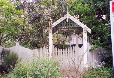 Eltham District Historical Society Inc
Photograph, Margaret Ball, 9 John Street, Eltham, 1999
"Kilbeggin Cottage" front gate, picket fence and garden obscures the weatherboard house over two blocks at 7 - 9 John Street, Eltham. Possibly a "For Sale" sign is at the side of the photograph for 11 John Street next door. Built about 1878 for carpenter Richard Bettison, John Street is part of the original Holloway subdivison in the area known as Little Eltham. The Margaret Ball (Pre 1960s Houses) Collection was a personal project initiated to mark the year 2000 and arose as a result of the disappearance of many pre-1960s parts of Eltham due to development. Approximately 200 pre-1960s style houses that were left in Eltham between Main Road and east to Bible Street, between Cecil Street to the north and south to Dalton Street were photographed in late 1999. Not all of the houses could be photographed; some because the garden or trees blocked the view of the house, others because of rubbish or cars were in the way, some because people were working on the house or in the gardens at the time.Roll of 35mm colour negative film, 7 stripsKodak GC 400-6eltham, houses, streets, margaret ball (pre 1960s houses) collection, john street -
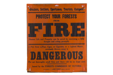 Forests Commission Retired Personnel Association (FCRPA)
Bushfire awareness sign, Protect your forests from fire, 1953
Bushfire Prevention Week was initiated by the Forests Commission in 1930. Victoria’s State Governor, Lord Somers, the Lord Mayor of Melbourne, Sir Harold Luxton and the newly appointed Minister for Forests, William Beckett launched the innovative campaign with great flourish to 250 invited guests at Melbourne’s opulent Town Hall on Monday 13 January 1930. Special church sermons had been held previously on Sunday. The packed program of gala events included lavish luncheon talks at city clubs, scholarly lectures broadcast on the wireless, together with daily articles in the Melbourne and country press about the pressing need for fire prevention. The slogan for the ground-breaking campaign was… Prevent Bush Fires – It Pays… The Shell Petrol Company of Australia supplied 15000 windshield stickers, the British Australasian Tobacco Company donated a large supply of stamp stickers, while many other companies drew attention to the campaign in their newspaper advertisements. The Victorian Railways and many city firms displayed special fire posters, while Bryant and May posted messages on their limited-edition matchbox covers which are now highly prized by phillumenists (i.e. matchbox collectors). The Postmaster General's Department franked postage stamps and letters with special bushfire slogans. While plainclothes police were secretly deployed to the bush to arrest potential arsonists. Canvas and enamel fire prevention signs were erected on most roads leading to forest areas. Letters to the Editor later appeared in many city and country newspapers extolling the virtues of Bushfire Prevention Week and urging for its continuation as an annual event. Although a new idea for Australia, the Canadian Forest Service had been running a similar program for a few years. The Forests Commission in its 1929-30 Annual Report, under the title of "Propaganda", noted with some glee… "One of the most gratifying features of the ''Week" was its low cost to the Government, the major part of the publicity material being donated by private firms." And so for the next 50 years until the 1980s, Bushfire Prevention Week continued unabated with the Forests Commission producing a series of coloured “Magic Lantern” slides which were manufactured by Alex Gunn and Sons in Collins Street Melbourne for screening at Val Morgan cinemas. The slides famously introduced the menacing character, Willy Wildfire, warning motorists to be careful with matches. Now known as Fire Action Week, it remains a key event in the annual calendar for both DEECA and the CFA and is still going strong... These canvas fire awareness signs were used right throughout the period of the Forests Commission until the mid 1980sBushfire awareness signProtect your forests from firebushfire, forests commission victoria (fcv), forest signs -
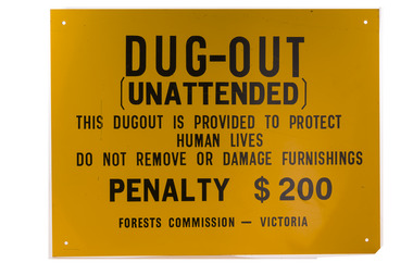 Forests Commission Retired Personnel Association (FCRPA)
Dugout sign, Post 1966
Considered in terms of both loss of property and loss of life, the Black Friday bushfires on 13 January 1939 were one of the worst disasters to have occurred in Australia and certainly the worst bushfire up to that time. The fires burnt 2 million hectares, 69 sawmills were destroyed, 71 people died, and several towns and sawmills were entirely obliterated. Among those killed were four men from the Commission The subsequent Royal Commission conducted by Judge Leonard Stretton has been described as one of the most significant inquiries in the history of Victorian public administration. Its recommendations led to sweeping changes. In addition to building dams and water points, the Stretton Royal Commission recommended expanding and controlling the use of bushfire dugouts at forest sawmills. Well-constructed dugouts had saved the lives of many sawmill workers and their families during the 1939 bushfires. But in some locations, they had proved fatal. Dugouts became mandatory for those few sawmills that remained in the forest after the 1939 fires. Many remote logging coupes and FCV roading camps also had dugouts. The local District Forester was required to make annual pre-season inspections of all dugouts on State forests and those within the Fire Protected Area (FPA). Some were built privately on private land. Most were primitive construction with a log or corrugated iron roof covered with earth. A hessian bag often hung at the entrance to keep the heat and smoke out. But they were dark and damp with snakes and other creepy crawlies often lurking inside. By 1940-41 there were 19 new dugouts constructed by the Commission and a further 128 by forest licensees. Ten years later there were 8 new Commission dugouts and 21 new ones built by other interests. By 1960-61 the rate of new builds was declining but the Commission still managed 103 dugouts while 127 were looked after by others. However, as the forest road network improved and gave all-weather access to modern two-wheel-drive vehicles the reliance on dugouts receded.Large metal sign that was positioned near forest dugoutsbushfire, forest signs, forests commission victoria (fcv) -
 Bendigo Historical Society Inc.
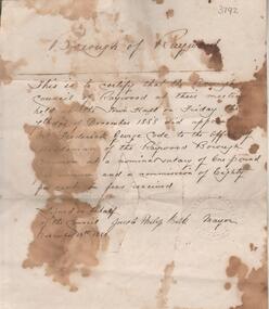
Administrative record - Borough of Raywood Frederick Code employment contract, November 13th, 1888
"This item was found in a suitcase of rubbish along Axe Creek Road, Longlea, in the mid 1970s. It has been stored in my photo album ever since. Code's had a property along Axe Creek/McIvor Highway and there is a Code's Lane there now. Anecdotal, and possibly quite untrue, they had a vineyard and were wiped out by phylloxera." ( Rodney Edwards, donor, 26th August 2024) One page document, parchment colour. Written across of document 'Borough of Raywood". Letter signed by Jacob Philip Balk Mayor, November 13th. 1888, outlining the employment details for Frederick George Code as 'the Officer of Herdsman of the Raywood Borough and Common at a nominal salary of one pound per annum and a commission of eighty per cent on fees received'. Handwritten on back of document: 'Bendigo Jam Factory 1902, January 11th. (indecipherable) lot Plums ten cases 2 ct 2 gr @ 40/-, 5.'frederick code, raywood pound, raywood common, axe creek, axedale, axedale pound -
 Flagstaff Hill Maritime Museum and Village
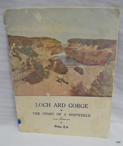
Book - Reference - history, Terang Express, Loch Ard Gorge, 1954
HISTORY OF THE LOCH ARD The LOCH ARD belonged to the famous Loch Line which sailed many ships from England to Australia. Built in Glasgow by Barclay, Curdle and Co. in 1873, the LOCH ARD was a three-masted square rigged iron sailing ship. The ship measured 262ft 7" (79.87m) in length, 38ft (11.58m) in width, 23ft (7m) in depth and had a gross tonnage of 1693 tons. The LOCH ARD's main mast measured a massive 150ft (45.7m) in height. LOCH ARD made three trips to Australia and one trip to Calcutta before its final voyage. LOCH ARD left England on March 2, 1878, under the command of Captain Gibbs, a newly married, 29 year old. She was bound for Melbourne with a crew of 37, plus 17 passengers and a load of cargo. The general cargo reflected the affluence of Melbourne at the time. On board were straw hats, umbrella, perfumes, clay pipes, pianos, clocks, confectionary, linen and candles, as well as a heavier load of railway irons, cement, lead and copper. There were items included that intended for display in the Melbourne International Exhibition in 1880. The voyage to Port Phillip was long but uneventful. At 3am on June 1, 1878, Captain Gibbs was expecting to see land and the passengers were becoming excited as they prepared to view their new homeland in the early morning. But LOCH ARD was running into a fog which greatly reduced visibility. Captain Gibbs was becoming anxious as there was no sign of land or the Cape Otway lighthouse. At 4am the fog lifted. A man aloft announced that he could see breakers. The sheer cliffs of Victoria's west coast came into view, and Captain Gibbs realised that the ship was much closer to them than expected. He ordered as much sail to be set as time would permit and then attempted to steer the vessel out to sea. On coming head on into the wind, the ship lost momentum, the sails fell limp and LOCH ARD's bow swung back. Gibbs then ordered the anchors to be released in an attempt to hold its position. The anchors sank some 50 fathoms - but did not hold. By this time LOCH ARD was among the breakers and the tall cliffs of Mutton Bird Island rose behind the ship. Just half a mile from the coast, the ship's bow was suddenly pulled around by the anchor. The captain tried to tack out to sea, but the ship struck a reef at the base of Mutton Bird Island, near Port Campbell. Waves broke over the ship and the top deck was loosened from the hull. The masts and rigging came crashing down knocking passengers and crew overboard. When a lifeboat was finally launched, it crashed into the side of LOCH ARD and capsized. Tom Pearce, who had launched the boat, managed to cling to its overturned hull and shelter beneath it. He drifted out to sea and then on the flood tide came into what is now known as LOCH ARD Gorge. He swam to shore, bruised and dazed, and found a cave in which to shelter. Some of the crew stayed below deck to shelter from the falling rigging but drowned when the ship slipped off the reef into deeper water. Eva Carmichael had raced onto deck to find out what was happening only to be confronted by towering cliffs looming above the stricken ship. In all the chaos, Captain Gibbs grabbed Eva and said, "If you are saved Eva, let my dear wife know that I died like a sailor". That was the last Eva Carmichael saw of the captain. She was swept off the ship by a huge wave. Eva saw Tom Pearce on a small rocky beach and yelled to attract his attention. He dived in and swam to the exhausted woman and dragged her to shore. He took her to the cave and broke open case of brandy which had washed up on the beach. He opened a bottle to revive the unconscious woman. A few hours later Tom scaled a cliff in search of help. He followed hoof prints and came by chance upon two men from nearby Glenample Station three and a half miles away. In a state of exhaustion, he told the men of the tragedy. Tom returned to the gorge while the two men rode back to the station to get help. By the time they reached LOCH ARD Gorge, it was cold and dark. The two shipwreck survivors were taken to Glenample Station to recover. Eva stayed at the station for six weeks before returning to Ireland, this time by steamship. In Melbourne, Tom Pearce received a hero's welcome. He was presented with the first gold medal of the Royal Humane Society of Victoria and a £1000 cheque from the Victorian Government. Concerts were performed to honour the young man's bravery and to raise money for those who lost family in the LOCH ARD disaster. Of the 54 crew members and passengers on board, only two survived: the apprentice, Tom Pearce and the young woman passenger, Eva Carmichael, who lost all of her family in the tragedy. Ten days after the LOCH ARD tragedy, salvage rights to the wreck were sold at auction for £2,120. Cargo valued at £3,000 was salvaged and placed on the beach, but most washed back into the sea when another storm developed. The wreck of LOCH ARD still lies at the base of Mutton Bird Island. Much of the cargo has now been salvaged and some was washed up into what is now known as LOCH ARD Gorge. Cargo and artefacts have also been illegally salvaged over many years before protective legislation was introduced. One of the most unlikely pieces of cargo to have survived the shipwreck was a Minton porcelain peacock - one of only nine in the world. The peacock was destined for the Melbourne International Exhibition in 1880. It had been well packed, which gave it adequate protection during the violent storm. Today, the Minton peacock can be seen at the Flagstaff Hill Maritime Museum in Warrnambool. From Australia's most dramatic shipwreck it has now become Australia's most valuable shipwreck artefact and is one of very few 'objects' on the Victorian State Heritage Register. Flagstaff Hill’s collection of artefacts from LOCH ARD is significant for being one of the largest collections of artefacts from this shipwreck in Victoria. It is significant for its association with the shipwreck, which is on the Victorian Heritage Register (VHR S417). The collection is significant because of the relationship between the objects, as together they have a high potential to interpret the story of the LOCH ARD. The LOCH ARD collection is archaeologically significant as the remains of a large international passenger and cargo ship. The LOCH ARD collection is historically significant for representing aspects of Victoria’s shipping history and its potential to interpret sub-theme 1.5 of Victoria’s Framework of Historical Themes (living with natural processes). The collection is also historically significant for its association with the LOCH ARD, which was one of the worst and best known shipwrecks in Victoria’s history. Book, Loch Ard Gorge: The Story of a Shipwreck by Alice Goldstraw. First published 1948, Third printing November 1954. Inscription inside front cover in blue pen, signed by the author. Soft covered book containing the story of the wreck of the Loch Ard, written in poetry. Each page has a decorative border. One page has photographs, black and white, of people and the Loch Ard Gorge cavesInside front cover, script in blue ink "To Mrs Slade, with kind regards, from Alice Goldstraw"flagstaff hill, warrnambool, shipwrecked coast, flagstaff hill maritime museum, maritime museum, shipwreck coast, flagstaff hill maritime village, great ocean road, loch line, loch ard, captain gibbs, eva carmichael, tom pearce, glenample station, mutton bird island, loch ard gorge, the story of a shipwreck, book, alice goldstraw, terang express press, loch ard gorge whipwreck, ship loch ard -
 Charlton Golden Grains Museum Inc
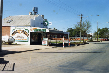
Photograph, Charlton Shire, Turner's Butcher Shop, Hight St Charlton, c.1987
Part of a Shire streetscape series of photos c. 1987Colour photograph of Turner's Butcher Shop on the corner of Learmonth and High Streets. Sign above the verandah reads Turners Butchery and has a picture of a ram's head between the two words. The signage on side of building reads Specialising in FEEDLOT STEAKS, QUALITY Pork & Lamb, Friendly Service. Deliveries. The sign on the side of the bullnose verandah reads TURNERS Butchery Phone 911506. A sandwich board in front of the shop on the edge of the footpath reads Butcher NOW OPEN. A white station wagon is parked in the yard beside the shop. There are two red and white school crossing posts on the rod in front of the shop. A building is under construction in the block across the road and there is orange safety fencing around the front of the block. The mill silos are visible behind the butcher shop.turner's butcher shop, high st charlton, learmonth st charlton, business -
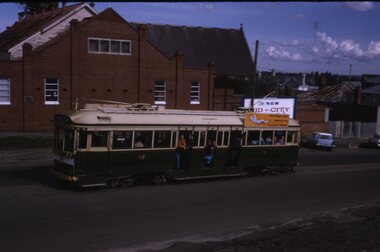 Ballarat Tramway Museum
Slide - Set of 7, Warren Doubleday, Ballarat - last Saturday of full operations, 21/8/1971
Photos taken on the last Saturday of full operations by the SECV in Ballarat prior to the first closure of the Victoria St line on 22/8/1971. 1 - Tram 42 climbing Victoria St with a sign for the site of the "New Mid - City Motel" behind. 2 - Tram 13 in Victoria St from the Anglican church tower with Black Hill in the background. 3 - Barkly and Main St from the Anglican church tower with an outbound tram the Ampol Service station in the view. 4 - Tram 39 in Wendouree Parade near depot with swans in the background. 5 - Ballarat 26 Wendouree Parade Olympic monument with the tram crossing from the side of the road into the middle of the road for Hamilton Ave. 6 - Trams 21 and 27 crossing at the Skipton St loop. 7 - Tram 27 and others on the ARHS tour at Sebastopol with the conductor unhooking the trolley pole rope before turning the pole. Yields information about the last full Saturday of SEC Tramway operations in Ballarat and has a strong association with the archivist. Set of 7 Kodachrome colour slides - cardboard mountsHave the photographer's slide numbers written on them.trams, tramways, closure, tram 26, tram 27, tram 13, tram 17, wendouree parade, victoria st, barkly st, tram 39, olympics, sebastopol, skipton st loop, tram 42, tram 21 -
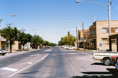 Charlton Golden Grains Museum Inc
Photograph, Charlton High St 1987, c.1987
High St Charlton 1987. Part of Shire of Charlton series of photos. National Australia Bank building. Established as Bank of Victoria in 1876, later became Commercial Banking Company of Sydney. Current building built in c. 1940Colour photo of High St, Charlton looking east. National Australia Bank on the corner of High & Armstrong Streets. Sign for Victoria Bitter and East Charlton Hotel on LH side. White car travelling toward photographer. Two people holding bicycles and standing next to a motor bike on LH side of road.high st charlton, national australia bank, bank of victoria, commercial banking company of sydney, charlton, business, industry -
 Glenelg Shire Council Cultural Collection
Print, Mary Macqueen, Nullabor 1-1-83, 1983
Print Council of Australia Members' Print Commission, 1983Abstracted views of a desert scene. A central road intersects image at a vertical diagonal. Faint outlines of houses and a WaterTower are scattered throughout the image. To the lefthand side a building can be seen with a veranda and several seating areas. To the righthand side there is another building and the numerals '1983' can be seen to the side of it. A railway crossing sign is positioned lower centre, at beginning of road. Kangaroos and trees can also be seen in the image. Dominant colour is a pinky red, with blue accents and grey shadows. Mounted in grey matt, in wooden frame. Front: Nullarbor (lower left of image) (ink) 35/100 (lower left) Nullarbor 1-1-83 (lower centre) Mary Macqueen 83 (lower right) (pencil) Back: (no inscriptions)nullabor, desert scene, female artists, female artist, abstract -
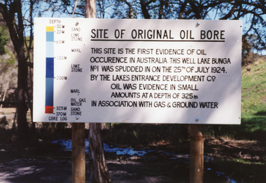 Lakes Entrance Historical Society
Photograph - Bunga No.1 Oil Bore
Seven other colour photographs very similar, before and after the bore was decommissioned and plugged 1996.Colour photograph of the sign at the Bunga Oil Bore site, on old Lake Tyers Road, near Lakes Entrance, Victoria.historic site, oil and gas industry -
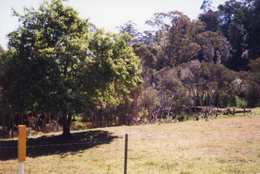 Lakes Entrance Historical Society
Photograph, 1999 c
Built by Captain Newman after retiring as Superintendent of Lake Tyers Aboriginal Station. The building was a shelter built beside the Toorloo road with a bell over the door and s sign 'Devonshire Teas served. For service ring the bell.' Operated by Mrs. Newman for a short timeA colour photograph of the site of the Toorloo Arm Tea Room, built about 1937. Shows a small clearing in a bushland setting. Toorloo Arm Victoriavegetation, local history, historic site -
 Bacchus Marsh & District Historical Society
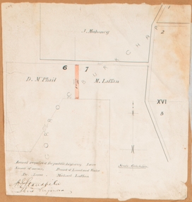
Map, Land required for a public highway near Rowsley, Victoria. Circa 1880s
... road. Rowsley Victoria Maps Signed by Shire Engineer, W.E ...This map indicates portions of land in the Parish of Gorrockburkchap near Rowsley which was required for construction of a road. The land required was leased to a Michael Laffan. Other blocks of land nearby owned or leased by D. McPhail and J. Mahoney are also indicated on the map. The date of the map is not known. However newspaper reports in the Bacchus Marsh Express on the 18 March 1882, page 3, column 3 mention land occupied by McPhail and Laffan near Rowsley in connection to the construction of a public road.Single page map showing land occupied by farmers D. McPhail and Michael Laffan which was required for a public highway. Scale 6 chains to inch. Part of a set of maps which are pasted into a bound volume containing 76 maps or plans in total. High resolution digital image stored on BMDHS computer network. Signed by Shire Engineer, W.E. Standfieldrowsley victoria maps -
 City of Kingston
Map - Parish of Moorabbin
Warning: This object includes historical language referring to First Nations Peoples which is no longer appropriate but has been recorded for historical purposes. Produced in 1853, this map shows the land holdings of European families. While the majority of holdings are small there are also large land holdings as can be seen with Henry Dendy's Special Survey. Of particular note is the "Reserve for Aborigines" which was established in approximately 1841 and consisted of over 830 acres. This area is the current location of Mordialloc township and Attenborough Park, in Mordialloc, is the last remnant of the reserve. An Alfred Sikes, possibly the surveyor/cartographer who drew this parish plan, purchased land in Berwick in 1854.A handrawn map on fabric, with blue markings representing the coastline to Port Phillip Bay, red markings representing a proposed train line to Mordialloc, major roads and street, as well as a "Reserve for Aborigines", which constituted approximately 830 acres. In the bottom right hand corner, the map has been signed and dated.Handwritten in ink: Alfred Sikes / 38 Collins St East / June. 1853moorabbin, mordialloc, dendy, port phillip bay, aboriginal reserve, attenborough park