Showing 10954 items matching " land"
-
 Kew Historical Society Inc
Plan - Subdivision Plan, Eastlawn Estate, 1914
Subdivision plans are historically important documents used as evidence of the growth of suburbs in Australia. They frequently provide information about when the land was sold on which a built structure was subsequently constructed as well as evidence relating to surveyors and real estate and financial agents. The numerous subdivision plans in the Kew Historical Society's collection represent working documents, ranging from the initial sketches made in planning a subdivision to printed plans on which auctioneers or agents listed the prices for which individual lots were sold. In a number of cases, the reverse of a subdivision plan in the collection includes a photograph of a house that was also for sale by the agent. These photographs provide significant heritage information relating house design and decoration, fencing and household gardens.The ‘Eastlawn Estate’ was surveyed and ready for auction in March 1914, three months before the outbreak of World War I. Sixty-six allotments, created on the ‘order of Mr & Miss Preston’ surrounded the mansion of Woodlands in Harp Road. Woodlands formed part of the Estate, being advertised as lot 1. The allotments faced High, Station and Wright Streets, Harp and Normanby Roads, and Woodlands Avenue. Pru Sanderson in the Kew Conservation Study (Vol.2, 1988) wrote that the Eastlawn Estate ‘covered the western half of the failed Harp of Erin Estate’. Contemporary advertisements promoted the Eastlawn Estate as: ‘There will be no more convenient district nor pleasant Suburb than East Kew for the busy business man. When the Electric Tram is laid, he will be able to journey quickly and pleasantly direct from Collins Street to his home in the Eastlawn Estate in about 20 minutes’. The actual plans of subdivision were included in advertisements in The Argus and in the local newspapers.subdivision plans - east kew, eastlawn estate -
 Hymettus Cottage & Garden Ballarat
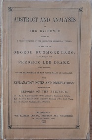
Work on paper - Book, Abstract and Analysis of the Evidence taken by A Select Committee of the Assembly of Victoria in the Case of George Dunmore Lang Late Manager and Frederic Lee Drake Late Assistant of the Bank of New South Wales at Ballaarat
Rev John Dunmore Lang's defence of his son who was imprisoned for his part in the fraud at the Bank of New South Wales Ballarat and Clunes in 1854.Small 95 page booklet published in 1857 by Fairfax, Melbourne and inscribed by W. D. Lang.non-fictionRev John Dunmore Lang's defence of his son who was imprisoned for his part in the fraud at the Bank of New South Wales Ballarat and Clunes in 1854.drake, lang, rev john dunmore lang, ballarat, clunes, select committee of enquiry -
 Sunbury Family History and Heritage Society Inc.
Photograph, Rosa McCall, Cumberland Homestead, 1951
The homestead in the image is 'Cumberland' which was sited along the Moonee Ponds Creek, near Gellibrand Hill. It was built by Donald Coghill, who acquired the land some time in the 1850s. During the first half of the twentieth century it was uninhabited until it was finally demolished.'Cumberland' was one of a number of homesteads that were built by European settlers in the Bulla area in the 1850s. A non-digital black and white photograph of a double storey Victorian homestead set in an open area.cumberland homestead, moonee ponds creek, gellibrand hill, donald coghill -
 Stawell Historical Society Inc
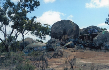
Photograph, Sister Rocks 2011-- Coloured photograph looking South
Colour Photograph Taken c 2011 Sister Rocks Stawell This photo is of a well known land mark along the Western Highway. They take their name from 3 sisters named Levy, who camped there with their parents during the early days of Stawell.Colour Photograph of Sister Rocks looking South c 2011South Taken c 2011stawell tourism -
 Greensborough Historical Society
Photograph - Digital image, Marilyn Smith, Old Ely House in Greensborough 2010, 03/07/2010
Recent photograph of one of the older houses in Greensborough. This house is in Grimshaw Street Photo taken at the very beginning of the construction of the Watermarc precinct. This house at 49 Grimshaw Street, along with the one next door at 47 Grimshaw Street were built by John Ely, son of Frederick Ely. John and his wife Melinda(Iredale), lived in Main Street (where is father Fred lived), then Grimshaw Street, John a labourer, later an assistant. John owned land in Grimshaw Street, where he built their home, he subdivided the land, this was when Eldale Avenue came to be, a combination of John’s and Melinda’s surnames. He sold a block of land, to Dr. E.R. Cordner, this is where the Cordner house, “Ashmead” was built. John and Melinda’s house later (mid 1970's) became a 'Ely House Medical Centre' owned by Drs. Myerscough and Hugh T McDonald . Alan (John's son) and Maisie’s a Physiotherapy Centre. Later Drs Stephen Hanslow and Dr. Eastern operated the medical centre. The house at 47 Grimshaw Street was demolished in 2017.Digital copy of colour photograph.grimshaw street greensborough -
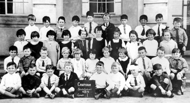 Surrey Hills Historical Society Collection
Photograph, Chatham State School Grade 1 1927, 1927
Chatham School, located in Weybridge Street Surrey Hills, was opened on 1 August 1927 following pressure from local residents as nearby schools (Balwyn, Mont Albert & Surrey Hills) were all over-crowded. This followed a surge in development following WW1. Land in surrounding streets was sub-divided. This included part of John Butler Maling (Jnr)'s small farm bounded by Banool Road, Wharton Road, Weybridge Street and Whitehorse Road. An area surrounding his home, 'The Willows' was retained and not sold until after he died in 1931. leased by Mr John Butler Maling in 1861. Three acres of his land were purchased by the Education Department. Some of the early students have referred to Chatham’s land as Mr Maling’s bull paddock. Some of the original yellow box trees remain on the property. The most significant of these is now called the Friendship Tree. On 1 August 1927 212 students were enrolled; Ralph Rae was one of these. The school was official opened on 15th February 1928. The school number is 4314. A black and white photograph of a group of 39 Grade 1 students from Chatham State School.1927, schools, chatham state school, clothing and dress, primary schools, john butler maling (jnr), ralph rae (mr) -
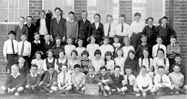 Surrey Hills Historical Society Collection
Photograph, Chatham State School Grade 5 1931, 1931
Chatham School, located in Weybridge Street Surrey Hills, was opened on 1 August 1927 following pressure from local residents as nearby schools (Balwyn, Mont Albert & Surrey Hills) were all over-crowded. This followed a surge in development following WW1. Land in surrounding streets was sub-divided. This included part of John Butler Maling (Jnr)'s small farm bounded by Banool Road, Wharton Road, Weybridge Street and Whitehorse Road. An area surrounding his home, 'The Willows' was retained and not sold until after he died in 1931. leased by Mr John Butler Maling in 1861. Three acres of his land were purchased by the Education Department. Some of the early students have referred to Chatham’s land as Mr Maling’s bull paddock. Some of the original yellow box trees remain on the property. The most significant of these is now called the Friendship Tree. On 1 August 1927 212 students were enrolled; Ralph Rae was one of these. The school was official opened on 15th February 1928. The school number is 4314. A black and white photograph of a group of 51 Grade 5 students from Chatham State School.schools, chatham state school, clothing and dress, primary schools, john butler maling (jnr), ralph rae (mr) -
 The Beechworth Burke Museum
Photograph, c1865
This was taken in 1865 of Spring Creek, Beechworth. Gold was discovered in this area in 1852 and within eleven months of this discovery, over 8000 hopeful prospectors had descended on the region, transforming the seemingly undisturbed land into what a visiting journalist in 1880s referred to as; "A Titan's Field". Huge mounds of earth were churned by hundreds of miners in search for gold, almost every available resource the land had to offer was used for something; even the bark off the gums were stripped to line huts and shafts. By 1857 more than 20,000 people lived in Beechworth, and with this influx the town prospered with the building of numerous churches, banks, schools, shops and hotels along with a prison and hospital.Black and white rectangular photograph. Image is printed on matte photographic paper and is mounted on cardboard. Obverse: NO INSCRIPTION Revese: 97.22.95 / 7772 / 25/1 / beechworth, burke museum, gold rush, 1865 -
 Warrnambool and District Historical Society Inc.
Plates, Rolfe Saucers x 6, 1864
These saucers are part of a crockery set that belonged to George Rolfe and his family. George Rolfe (1836-1919) was a tea merchant in Melbourne who bought land at the mouth of the Hopkins River in Warrnambool in the 1880s. He had adjoining land and the properties of ‘Shipley’ and ‘Fairy Hill’ and developed ‘Lyndoch’, adding stables, jetty, boat house, windmill and reservoir, chaff and bone sheds and an extensive garden. In 1891 he married Annie Lake and it was his stepdaughter, Florence Lake who built the ‘Lyndoch’ house still standing today. ‘Lyndoch’ today is now the site of an Aged Care Facility. This item is part of the Rolfe Dinnerset as described on Victorian Collections at VC001420 and VC001422.These saucers, part of a crockery set, are kept because they belonged to George Rolfe, a prominent property owner and farmer in Warrnambool in the late 19th century and early 20th century. The items, dating from 1864, have social significance showing the type of crockery used by a more affluent family in the 19th century. These are six circular china saucers with a gold rim and ornamentation in a scallop design in gold and teal around the rim and the outer edges. The base of the saucers has a gold rim. One of the saucers has a chip on the edge and four show significant wearing of the inner gold circle. Some of the outside gold edging also shows wear. The maker’s marks and name are indented on the bottom of the saucers ‘Minton’ lyndoch, warrnambool, rolfe and co., george rolfe, history of warrnambool, florence lake -
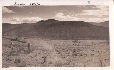
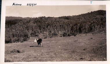 Kiewa Valley Historical Society
Black and white photograph of farmland, Kiewa, 25/8/38, circa 1938
This photograph was taken in August, 1938, some eight years prior to the establishment of Mt. Beauty a a township. The area was still being used for grazing, and the land was eventually acquired from the local land owners by the State Electricity Commission. The construction of the road, from Tawonga to the High Plains, was commenced in April, 1938 and this photograph was taken August, 1938. This allowed men and heavy equipment to be transported to the work sites for the construction of the Kiewa Hydro Electric Scheme. Prior to this access was by bridle trail, either on horse back or on foot. By 1946 housing construction had commenced for the new town of Mt. Beauty and by 1948 street construction in the southern part of the town was completed as far as Hill Street.This photograph is important as it shows the upper Kiewa Valley as it was before the establishment of the town of Mt. Beauty. The land has been cleared of natural vegetation to allow grazing of cattle. Black and white photograph of grazing farmland with one animal standing in the paddock. The area could possibly be where the golf course now stands with the road to the high plains not yet commenced.Handwritten in the upper left hand corner 'Kiewa 25/8/38'. The number 7 has been stamped in the upper right hand corner. It is part of a set of 8 photographs. On the back are the words Velox repeated several times, indicating the type of photographic papergrazing, kiewa, mt. beauty, secv -
 Kiewa Valley Historical Society
Photograph Farm Land, Kiewa, 25/8/38, circa 1938
This photograph was taken in august, 1938 some eight years prior to the establishment of Mt. Beauty as a township. The area was still being used for grazing cattle and the land was eventually acquired from the local land owners by the State Electricity Commission. The construction of the road, from Tawonga to the High Plains, was commenced in April of 1938. This allowed men and heavy equipment to be transported to the work sites for the construction of the Kiewa Hydro Electric Scheme. Prior to this access was by bridle trail, either on horse back or by foot. By 1946 housing construction had commenced for the new town of Mt. Beauty and by 1948 street construction in the southern part of the town was completed as far as Hill Street.This is an important photograph as it shows the upper Kiewa Valley and the site for Mt. Beauty as it was before the establishment of the town. The land has been cleared of natural vegetation and used for grazing cattle.Black and white photograph of farmland, cattle in the distance, hills in the backgroundHandwritten in the upper left hand corner, in black ink, 'Kiewa 25/8/38'. The number 8 has been stamped in the upper right hand side of the photograph. On the back have been stamped the words Velox, indicating the type of photographic paper.kiewa, mt. beauty, construction, grazing, secv -
 Eltham District Historical Society Inc
Photograph, Maurie Fabbro at age 20 at Fabbro's farm in Bell Street, Eltham, 1940, 1940
The site of the Fabbro farm (Diamond Creek side land) is now called Barrack Bushlands. It is doubtful that Fabbro's farm holding was ever called Barrak Park, This title is fairly recent after the Shire of Eltham purchased the land, including the last section in 1993/94. About this time the area on the west side of Falkiner Street was purchased by a private developer and developed as housing. The area in Bell Street opposite the Eltham High School was purchased by the State Government is recent years and is called Fabbro Fields. The Fabbro Family operated their farm in Bell Street, Eltham. Maurice Joseph Fabbro (Mario) was born 19 January 1920 and passed away 19 November 20091 black and white photographfabbro's farm, maurice fabbro -
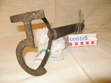 Warrnambool and District Historical Society Inc.
Functional object - Farming Equipment Branding Iron, Circa 1840
Armyne, George and Lemuel Bolden were original landholders of large parts of land in the Western district. Portions of it extended from Pirron Yallock in the East to almost as far as Portland. The head station was at Grasmere. They were noted breeders of shorthorn cattle in fact they were some of the first men to bring the breed to Victoria and thus helped to pioneer the Australian Shorthorn breeding Industry. This branding iron was found at Lyall Park, originally 640 acres selected by William Lyall at Cooramook. It is believed to be a branding iron dating from when the land was occupied by the Bolden Brothers. The Bolden Brothers were the first to erect considerable lengths of fencing in the Warrnambool area. If this item is an authentic Bolden piece of property then it is the oldest artefact from the time of white settlement that is held by the Warrnambool and district Historical society. The item itself while a common farming implement and which was found on a farm originally owned by the Bolden Brothers is a link with the earliest part of Warrnambool’s history.Short, round wooden handle with metal brand in the shape of the letter T with two thirds circle attached to vertical part of T. Daub of paint at end of handle . T 5Paper label attached with green tape with 931 in texta and hand written on back,” branding iron reputed to have been used by Bolden Bros Grasmere c 1840. warrnambool, bolden brothers, armyne bolden, george bolden, lemuel bolden, branding iron, shorthorn cattle -
 Glen Eira Historical Society
Document - GARDENVALE
This file contains two items about Gardenvale, which was previously all part of Caulfield: 1/Photocopied eight page document by M. Stewart, 1961, entitled ‘The Gardenvale Story’. It describes Gardenvale Railway and surrounding roads and land. Lempriere’s Paddock, rail tracks on the main roads for the use of market gardeners’ wagons. Sale of land for O’Neill College Estate and construction of a subway through the railway embankment to Gardenvale Shopping centre, including efforts by local people and the council for work to be completed and costs. Footnote is circa 1977. 2/Map of Glen Eira printed from Council website 20/06/2014 showing Glen Eira’s share of Gardenvale.gardenvale, bent thomas, brighton, caulfield, elsternwick, railway stations, lempriere family, ‘bentville’, lempriere’s paddock, market gardens, nepean highway, nepean road, north road, kooyong road, polo, sheridan family, bluestone houses, bethlehem hospital, land subdivision, begonia street, gardenia road, gardenia street, magnolia street, lantana street, martin street, shops, ‘ben burb’, house names, padua hospital, brighton, o’neill miss, o’neill college, o’neill richard, o’neill estate, elster avenue, o’neill college estate, railway crescent, denver crescent, brentani avenue, college street, rosstown railway, brighton cemetery, ross mr, hawthorn road, ormond, gardenvale progress association, elster creek, parliamentary representatives, landscapes, gardenvale road, railway lines, subways, traders association, drainage, floods -
 City of Moorabbin Historical Society (Operating the Box Cottage Museum)
Photograph, B&W William & Elizabeth Avis Box c1880, c1880
William Box was born in 1834 in Withyham , Sussex England and married Elizabeth Avis Box in 185. They sailed to Australia in1855 aboard the SS Omega. At first they rented and then purchased land on Jasper Road East Brighton ( now McKinnon / Ormond) that was part of the Henry Dendy Special Survey 1841. An early settlers’ Cottage on the site became their home and they farmed the land while raising 13 children. The Cottage was extended as required. In 1984 that early settler cottage was found in a dilapidated state by Laurie Lewis, in his Timber Yard in Jasper Rd Ormond.. The Moorabbin City Council, Federal Government, Mr Lewis and CMHS members reconstructed the Cottage in 1985 . Box Cottage Museum, a reconstruction of an early settler hut, is named after the Box family who resided there 1865 -1913 . William Box who with his wife Elizabeth Avis and 13 children lived and farmed on the block of land in Jasper Road, East Brighton ( now McKinnon / Ormond) that was part of the Henry Dendy Special Survey 1841 Inscribed in Album “ The early photos in this album were found by Mr (Laurie) Lewis when he was demolishing the Old Box Cottage. He gave them to Mrs Avis Box Eldridge who in turn gave them to me. They were not identified. I believe they rightly belong in the Cottage. I have attempted to identify them and present them in a way they can be preserved as a historical record of the era.” A B Leigh A black and white photograph of William and Elizabeth Avis Box standing outside their Cottage in East Brighton c 1880nilbox george, box mary, box william, box elizabeth honor, box alonzo, box mary louisa, dendy henry, were j b, dendy's special survey 1841, brighton, moorabbin, bentleigh, mckinnon, ormond, market gardeners, dairy farms, early settlers, pioneers, jasper road, gurr jabez, gurr eliza, pay henry, pay anna, ward willam, box henry, ward elizabeth emma, box john, sheldrake martha, rushall eleanor, box caroline, box elizabeth avis, -
 City of Moorabbin Historical Society (Operating the Box Cottage Museum)
Photograph, B&W Box Family descendants c 1930, 20thC
William Box was born in 1834 in Withyham , Sussex England and married Elizabeth Avis Box in 1854. They sailed to Australia in 1855 aboard the SS Omega. At first they rented and then purchased land on Jasper Road East Brighton ( now McKinnon / Ormond) that was part of the Henry Dendy Special Survey 1841. An early settlers’ Cottage on the site became their home and they farmed the land while raising 13 children. The Cottage was extended as required. In 1984 that early settler cottage was found in a dilapidated state by Laurie Lewis, in his Timber Yard in Jasper Rd Ormond.. The Moorabbin City Council, Federal Government, Mr Lewis and CMHS members reconstructed the Cottage in 1985 . Box Cottage Museum, a reconstruction of an early settler hut, is named after the Box family who resided there 1865 -1913 . William Box who with his wife Elizabeth and 13 children lived and farmed on the block of land in Jasper Road, East Brighton ( now McKinnon / Ormond) that was part of the Henry Dendy Special Survey 1841 Inscribed in Album : “ The early photos in this album were found by Mr (Laurie) Lewis when he was demolishing the Old Box Cottage. He gave them to Mrs Avis Box Eldridge who in turn gave them to me. They were not identified. I believe they rightly belong in the Cottage. I have attempted to identify them and present them in a way they can be preserved as a historical record of the era.” A B Leigh A black and white photograph of descendants of the William Box Family who lived at Box Cottage.box george, box mary, box william, box – tippett elizabeth honor, box alonzo, box mary louisa, dendy henry, were j b, dendy's special survey 1841, brighton, moorabbin, bentleigh, mckinnon, ormond, market gardeners, dairy farms, early settlers, pioneers, jasper road, gurr jabez, gurr eliza, pay henry, pay anna, ward willam, box henry, ward elizabeth emma, box john, sheldrake martha, rushall eleanor, box caroline, box elizabeth avis, box harold, box olive camera, box fredrick, eagle keith, box –cumming, ida, cumming william, box – jackson dorothy, eagle nancy, box – eagle thelma, cumming william, box maude, jackson margaret , box- eldrige avis, -
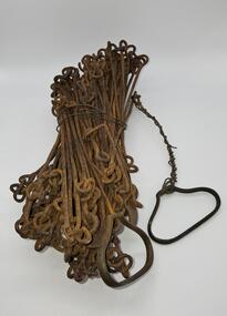 Glenelg Shire Council Cultural Collection
Equipment - Surveyors chain, unknown
Before metric measurement was introduced land was measured by a tool of chains and links called a surveyor's chain. The first surveyor's chain was designed by the English clergyman and mathematician Edmund Gunter (1581-1626) and introduced in 1620. It comprised of a metal chain made up of 100 links measuring a precise overall length of 66 ft or 22 yards, with each link measuring 7.92 inches (201.168 mm). The Gunter's chain was originally intended to be used in the accurate laying out and measurement of plots of land, for legal and commercial purposes, but was subsequently widely used by surveyors throughout the British Empire and Europe, with an Imperial mile being 80 times the Gunter's chain length. A tool used to survey the land before the introduction of the metric system.Surveyor chain Gunter type, 100 links measuring 66 feet in length. Hand grips at each end of chain. Wire links are approximately eight inches long. Incised tags or markers are attached to each tenth link of chain to assist with the more accurate recording of intermediate distances.surveying tool -
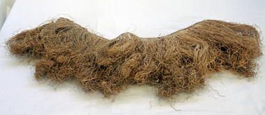 Orbost & District Historical Society
grass skirt, approx. 1905
Worn by Mrs Jack Mundy while in New Hebrides. The Mundy family were farmers / settlers in the Snowy River area since c. 1880s. The original Mundy family moved to a land "selection" at Bete Bolong in the early 1880's from Buchan. Mundy familyHandmade grass skirt made of native plant fibres and held together with knotting along the top. Natural colour.nonegrass-skirt new-hebrides mundy costume-female native-materials -
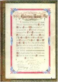 Warrnambool and District Historical Society Inc.
Document - Illuminated Address Gideon Nicol, 2014
Gideon Nicol (1836-1908) was a seaman who came to Warrnambool in 1858. In 1865 he selected land at Mount Warrnambool . He was one of the founders of the Farnham Cheese and Butter Factory and the Garvoc Cheese and Butter Factory and was a Shire Councillor from 1879 to 1906. These items will be useful to include in the Gideon Nicol file.These are scans of two pages from a book and an illuminated manuscript. One page is red with an ornate border and the other is blackish with an ornate border. The illuminated address is multi-coloured with an ornate border‘Gideon Nicol, July 16th 1906’; ‘G.N.’warrnambool, gideon nicol, illuminated address, warrnambool shire, garvoc butter and cheese company -
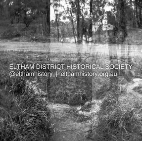
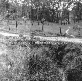 Eltham District Historical Society Inc
Negative - Photograph, J.A. McDonald, Fordhams Road, Eltham, 24 July 1962
Culvert discharging towards land owned by Holloway & Spicer about 3pm on 24 July 1962 Heavy rain 60 years later it still appears to present as a concern - see Google Street View (Nov 2021) https://goo.gl/maps/x61yWvAc5UjJ2d8y9Record of various Shire of Eltham infrastructure works undertaken during the period of 1952-1962 involving bridge and road reconstruction projects, sometimes with Eltham Shire Council Project Reference numbers quoted. It was during this period that a number of significant improvements were made to roads and new bridges constructed within the shire that remain in place as of present day (2022). In many situations, the photos provide a tangible visible record of infrastructure that existed throughout the early days of the Shire. The album was put together by or under the direction of the Shire Engineer, J.A. McDonald.1962-07-24, culvert, eltham, fordhams road, infrastructure, shire of eltham -
![Advertising Leaflet, Grace Park Electric Station Estate, Watsonia [3], 21/06/1924](/media/collectors/4f729f5697f83e03086015b8/items/5dcfb9c821ea671434edd447/item-media/5dcfb9e821ea671434ededfc/item-fit-380x285.jpg) Greensborough Historical Society
Greensborough Historical SocietyAdvertising Leaflet, Grace Park Electric Station Estate, Watsonia [3], 21/06/1924
Digital copy of auction leaflet for sale of land known as Grace Park Electric Station Estate, Saturday 21/06/1924. Auctioneer Knight & Harwood in conjunction with C. Jessop. This leaflet shows a photograph of the 'Grace Park Railway Station' nearing completion.Digital copy of auction leaflet 1 page. Black and red text on white paper.watsonia, grace park -
 Orbost & District Historical Society
bill file, early 20th century
Ossie Green was a retired primary school principal living in Marlo. He wrote many historical books including Marlo The Township; The Plains The Cape. Mrs Green was a McKeown from Marlo. McKeowns had large land holdings around Marlo for farming.This item is an example of a commonly used item in the late 19th -early 20th century. It reflects a time when accounts were made of paper and retained as records by households. Black cast iron billfile. Ornate design with large spike.bill-file ornaments-metal green-ossie mckeown -
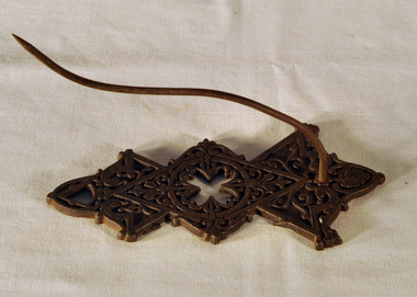
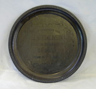 Orbost & District Historical Society
advertisement, before 1933
John Tomlinson was the eldest son of Arthur James and Jessie Tomlinson who selected land at Tabbara in 1887. He worked in Temple's , the Herbert's store and for the Butter Factory until beginning his own business in 1906. He remained in business until 1933.A round metal tray with decorated edge. It is an engraved advertisement for J.S. Tomlinson.advertisement tomlinson commerce-orbost -
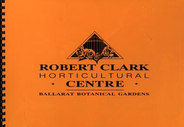 Federation University Historical Collection
Booklet, Robert Clark Horticultural Centre: Ballarat Botanical Gardens, c1993
"The 250 acres of land to the west of Yuilles Swamp (Lake Wendouree) was permanently granted to The Corporation of the City of Ballaarat by the State Government on the 23rd December 1857 for the purposes of a 'Botanical Garden for the recreation, education and enjoyment of the community." The Robert Clark Horticultural Centre was opened in 1995.Large format spiral bound booklet with yellow cover. Bordered pages with writing or coloured photographsyuilles swamp, lake wendouree, corporation of the city of ballaarat, botanical gardens, recreation, education, horticulture, robert clark, ballarat botanical gardens, robert clark centre, robert clark horticultural centre -
 Hume City Civic Collection
Photograph, Late 1980's
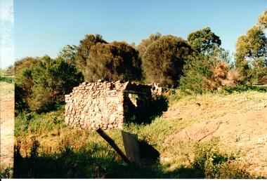
The Millbrook ruins are on a property which was created by John Pascoe Fawkner's Victoria Co-operative Freehold Land Investment Society. The aims of the company were to provide smallholdings to poorer settlers who wanted to farm. The ruins are now part of the Organ Pipes Park.A coloured photograph of stone ruins built on a hillside with sheoaks and other vegetation behind it. There is a doorway at the end of the small building.fawkner, john pascoe, millbrook ruin, jacksons creek, organ pipes park, victorian co-operative freehold land investment society, george evans collection -
 Hume City Civic Collection
Brick
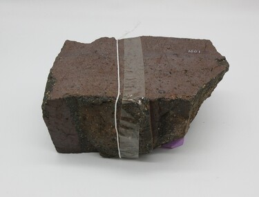
This half broken brick comes from the brickworks owned by Robinson Allison. The brickworks operated approximately between the years 1859 - 1883 on crown land near Watson's Road, Sunbury. This brick may have come from a ruin near the Organ Pipes.Approximately half a brick brown/red colour smooth at one end uneven sides.on top - "ALLISONS'1860s, 1880s, sunbury, brick, shire of bulla, dunn, trevor, margaret, allison, robinson, george evans collection -
 Kew Historical Society Inc
Plan - Subdivision Plan, Windella-Darnley Subdivision, Studley Park, 1920s
Subdivision plans are historically important documents used as evidence of the growth of suburbs in Australia. They frequently provide information about when the land was sold on which a built structure was subsequently constructed as well as evidence relating to surveyors and real estate and financial agents. The numerous subdivision plans in the Kew Historical Society's collection represent working documents, ranging from the initial sketches made in planning a subdivision to printed plans on which auctioneers or agents listed the prices for which individual lots were sold. In a number of cases, the reverse of a subdivision plan in the collection includes a photograph of a house that was also for sale by the agent. These photographs provide significant heritage information relating house design and decoration, fencing and household gardens.Version 2 of two subdivision plans (the earlier is 2016.0305.1) for the section of Studley Park Road near the Junction on the south side. Named in the subdivision are the mansions of Darley and Windella (now demolished). Before the subdivision of Darley and Windella, both houses fronted Studley Park Road. Both houses appear to be advertised as lots in the subdivision. Bisecting the subdivision is a street, Antrim Avenue that was never constructed. A street, which was subsequently constructed in this vicinity, was Merrion Place, which now runs between Studley Park Road and Highfield Grove. There are 13 proposed lots in this subdivision in contrast to the earlier plan. This resulted from larger lots being proposed for Studley Park Road.subdivision plans - kew, studley park, windella, darnley, antrim avenue -- kew (vic.), studley park road -- kew (vic.), merrion place -- kew (vic.), merrion grove -- kew (vic.), highbury grove -- kew (vic.) -
 Expression Australia
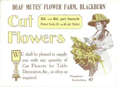
Advertising Card, Cut Flowers - Deaf Mutes' Flower Farm, Blackburn
The Australian Deaf and Dumb Society of Victoria purchased and developed land at Blackburn Lake as a flower farm, the idea being to provide light occupation for the deaf and dumb unable to follow other regular employment, A home for aged and infirm deaf was also erected on the property.A rare example of advertising produced by the Adult Deaf and Dumb Society of Victoria for its Flower Farm at BlackburnSize 15.5cmHx21cmWlake park, blackburn, flower farm, deaf -
 Expression Australia
Advertising Booklet, Lake Park Blackburn - The Idael Place for Pic-Nics
The Australian Deaf and Dumb Society of Victoria purchased and developed land at Blackburn Lake as a flower farm, the idea being to provide light occupation for the deaf and dumb unable to follow other regular employment, A home for aged and infirm deaf was also erected on the property.A rare booklet advertising Lake Park Blackburn as an ideal public picnic spot.Size 12cmHx15cmW; 12 pages