Showing 10832 items
matching maps
-
 Whitehorse Historical Society Inc.
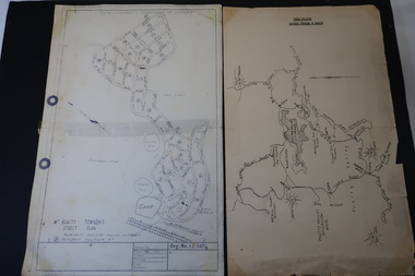
Document, Municipal Reserve, n.d
Hand drawn map of blocks and municipal reserve off Anjaya Court, Blackburn.parks and reserves, anjaya court, blackburn -
Whitehorse Historical Society Inc.
Map, Aboriginal sites in the City of Doncaster-Templestowe, 1/03/1991 12:00:00 AM
Map of City of Doncaster and Templestowe.Map of City of Doncaster and Templestowe showing location of stone artefacts and scarred trees.Map of City of Doncaster and Templestowe. aborigines, city of doncaster and templestowe -
 Whitehorse Historical Society Inc.
Document, Heritage Family Day 2018, 2018
Heritage Family Day 2018 'A Walk in the Park' leaflet, map and Royalauto advertisement.Heritage Family Day 2018 'A Walk in the Park' leaflet, map and Royalauto advertisement.Heritage Family Day 2018 'A Walk in the Park' leaflet, map and Royalauto advertisement.heritage family day 2018, city of whitehorse, schwerkolt cottage & museum complex -
 Ballarat Heritage Services
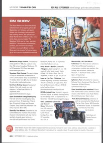
Map, Australian Colonies (States), c1918
Copy of a map from 'A Short History of Australia' by Ernest Scott published in 1918. map, australia, indian ocean, van dieman's land, tasmania, new south wales, sydney, western australia, perth, albany, launceston, hobart, south australia, melbourne, townsville, rockhampton, brisbane, northern territory, queensland -
 RMIT Design Archives
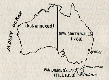
Mixed media - Drawings, Design for clothing label featuring map of Australia
Cash's first began manufacturing name tags, woven badges and woven labels in Australia in 1913, and since then countless Cash's labels have been sewn onto school and club jumpers. Point paper design featuring map and flag. Corresponding clothing label attachedtextile design, rmit design archives -
 8th/13th Victorian Mounted Rifles Regimental Collection
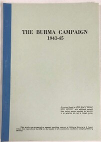
Book, The Burma Campaign
A series of study notes covering the military campaign in Burma during the Second World War.Green soft covered booklet, 93 pages, maps and diagrams,, thermal binding.non-fictionA series of study notes covering the military campaign in Burma during the Second World War.wwii, world war two, moore, history, burma -
 Running Rabbits Military Museum operated by the Upwey Belgrave RSL Sub Branch
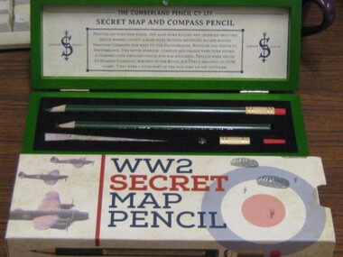
Secret Map and Compass Pencils
Two pencils in green wooden case, with map. Given to Lancaster airmen WW2.equipment, ww2, raf -
 Port Fairy Historical Society Museum and Archives
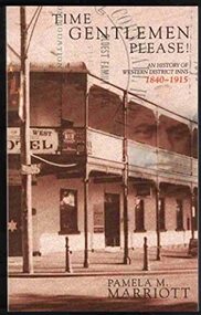
Book, Pam Marriott, Time gentlemen please! : an history of Western District inns, 1840-1915, 2001
Time Gentlemen Please! : A History of Western District Inns 1840-1915 An historical record of the public houses, which flourished in Belfast and Western District during the timeframe, complete with licensees.xix, 327 p. : ill., map, ports. ; 24 cm. Includes indexnon-fictionTime Gentlemen Please! : A History of Western District Inns 1840-1915 An historical record of the public houses, which flourished in Belfast and Western District during the timeframe, complete with licensees.bars (drinking establishments) -- victoria -- western district, victoria -- social life and customs -- 1901-1945, victoria -- social life and customs -- 1834-1900, book -
 Bacchus Marsh & District Historical Society
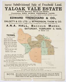
Map, Edward Trenchard & Co, Important Subdivisional Sale of Freehold Land Yaloak Vale Estate
A land sales map and advertisementLand sales advertising poster with map indicating specific lots of land for sale.A land sales map and advertisementimportant subdivisional sale of freehold land yaloak vale estate, land sales -
 Ringwood RSL Sub-Branch
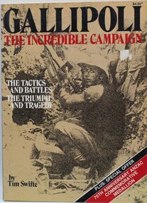
Book, Gallipoli. The incredible campaign, 1985
Soft cover. 130 pages containing text black and white photos and mapsKen R ? -
 Wodonga & District Historical Society Inc
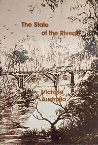
Book - The State of the Rivers, Victoria Australia, Constable, D & Smith, K, 1983
Rivers play an essential part in the life and wealth of our society. They are also the most striking feature of the landscape, contributing much to the beauty of rural and urban surroundings as well as to the recreation, peace and happiness of our people. This report includes historical colour and black and white photos and maps. It aimed to give an accurate account of the condition of the rivers of Victoria. It was produced by the Standing Consultative Committee on River Improvement.A 64 page volume including text, black and white and colour images and maps.Rivers play an essential part in the life and wealth of our society. They are also the most striking feature of the landscape, contributing much to the beauty of rural and urban surroundings as well as to the recreation, peace and happiness of our people. This report includes historical colour and black and white photos and maps. It aimed to give an accurate account of the condition of the rivers of Victoria. It was produced by the Standing Consultative Committee on River Improvement.rivers in victoria, conservation victoria, water supply victoria -
 Falls Creek Historical Society
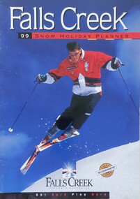
Magazine - Falls Creek 99 Snow Holiday Planner
Part of an annual marketing campaign, this booklet was designed to provide information for planning a holiday at Falls Creek for the winter of 1999. It includes details about activities, facilities and accommodation in the Village as well as contact information to make necessary bookings.This item is important as it documents seasonal activities at Falls Creek Alpine ResortA booklet containing detailed information and images including a map, prices and booking details.falls creek, winter sport, 1990s, falls creek marketing -
 Falls Creek Historical Society
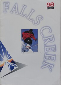
Magazine - Falls Creek 98 Holiday Planner
Part of an annual marketing campaign, this booklet was designed to provide information for planning a holiday at Falls Creek for the winter of 1998. It includes details about activities, facilities and accommodation in the Village as well as contact information to make necessary bookings.This item is important as it documents seasonal activities at Falls Creek Alpine ResortA booklet containing detailed information and images including a map, prices and booking details.falls creek, victoria, winter sport, falls creek marketing -
National Vietnam Veterans Museum (NVVM)
Photograph, Sketch of Battle Map, Ngok Tavak, Mary 1968
Captain John E D White, Australian Army Training Team in Vietnam (AATTV) took over command of 11 Mobile Strike Force (Mike Force) Company in Da Nang, Vietnam, in February 1968. He was 26 years old. The 2 NVA Division was moving from Laos into South Vietnam and his mission was to establish contact with the division and trace its movements south. In mid-March the company was air lifted to the Special Forces camp of Kham Duc, near the Laotian border. They used an old French Foreign Legion fort as a temporary base from which patrols could be sent out. White called it Ngok Tavak after a nearby mountain. Initially, patrols failed to find the enemy, but in late April a patrol clashed with the enemy. At the same time, White received intelligence that the NVA division was closing in. At night they could hear explosions in the distance heading toward them. White decided their best chance was to leave the fort and take to the jungle to adopt guerrilla tactics. However, in the meantime a platoon of United States Marine Corps artillery arrived bringing with them two howitzers and a stockpile of ammunition. To abandon the fort was to abandon the guns. White contacted Da Nang, explaining the predicament, and was ordered to remain where he was. A Civilian Irregular Defense Group (CIDG) platoon was sent to reinforce his numbers. This was a para military force comprised mainly of indigenous highlanders, trained by United States Special Forces. They also brought with them two mortars and their crews. At 3.15am on 10 May 1968 some members of the CIDG chose to assist the NVA to attack the fort instead of supporting Mike Force, and close hand to hand fighting followed, along with grenade attacks and heavy machine gun fire. Air support offered a brief respite from the NVA attack, and some NVA forces were pushed back outside the perimeter by counter attacks, but at 9am White contacted Da Nang to advise that his position was untenable. A second attack was imminent and they could not withstand it, so they would have to withdraw. The wounded were evacuated by helicopter (under orders from Major Mai, the NVA had not attacked the previous medical helicopters that collected the wounded under the cover of air strikes) and at 1pm the rest of the force evacuated east, into the jungle. The NVA did not notice their withdrawal, and continued mortar attacks on the fort for another ninety minutes. Seven kilometres from the fort White called for a helicopter withdrawal of his forces. The force was successfully lifted to Kham Duc and then Da Nang. (Credit AWM)Annotated hand-drawn map of the fort at Ngok Tavak, 10 May 1968.battle of ngok tavak, john white, battle map -
 Federation University Historical Collection
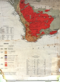
Map, Geological Map (Southern Western Australia), post 1880
Includes the routes of exploration, including E. Giles, A. W. Howitt, Burke & Wills, Hume & Hovell, Major Mitchell, A Forrest.A section of a map showing geology and routes of exploration. Southern Western Australia only geology, exploration, railways, electric telegraphs -
 Bendigo Historical Society Inc.
Book - STRAUCH COLLECTION: WHROO CEMETERY VICTORIA
Although the first recorded burial at Whroo (7 km south of Rushworth) was in 1858, it is believed earlier unrecorded burial took place. The official cemetery was established in 1860 and contains approx. 400 burials although many are unmarked. There is also a Chinese section as in 1863 17% of the population was Chinese in 1863.Red Spring binder containing list of interments in Whroo Cemetery with maps & illustrations.James & Nicola Thomsonplace, cemetery, whroo, victoria-whroo-rusthworth-history-cemetery -
 Bendigo Historical Society Inc.
Book - STRAUCH COLLECTION: RESEARCHING YOUR GERMAN ANCESTORS
BHS CollectionManilla folder containing information on researching your German ancestors with illustrations and a map.genealogy, family, german, genealogy-german -
 Bendigo Military Museum
Photograph - Detachment - Army Survey Regiment, Bonegilla, Victoria, c1973
This is a set of three photographs of personnel from the Detachment - Army Survey Regiment taken in front of its main map production building at Bonegilla, Victoria in c1973. This cartographic map production sub-unit of the Army Survey Regiment operated in buildings owned by the School of Military Survey from 17th of June 1970 to the 30th of September 1985. A total of 800 topographic maps ranging in scale from 1:25,000 to 1: 250,000 scale were completed. A major focus of production in the 1970s was the cartographic completion of the Papua-New Guinea 1:100,000 map series and the Flexiflow quality control system was developed as a tool to coordinate production. The Flexiflow system comprised a series of job plans and charts linked to a task allocation to resource magnetic planning board. Using critical path analysis and task prioritisation, complex job planning was efficiently scheduled, and re-prioritisations readily made. Reproduction requirements were effectively coordinated by way of weekly courier to the Army Survey Regiment at Bendigo. Supervisors and technicians fully embraced the system as they could understand their role, others around them and the positive production achievements. WO1 Bill Boyd (who does not appear in this photograph) was the technical warrant officer for 11 years at the Detachment was awarded the OAM, the Order of Australia Medal for leading the development and the implementation of the Flexiflow system. By mid-1982, production of maps at these scales was undertaken digitally on Bendigo’s AUTOMAP 2 system and the Detachment reverted to production of small-scale large format RAAF aeronautical charts. Detachment personnel managed to produce 18 charts in the following two years, which was an impressive achievement for the staff, given major differences in format, specification and scales. Development of digital production of aeronautical charts in 1984-85 led to gradual reduction in production output and contracting out production was instigated to meet the shortfall and as a consequence the Detachment closed in September 1985. See pages 177 to 180 of Valerie Lovejoy’s book 'Mapmakers of Fortuna – A history of the Army Survey Regiment’ ISBN: 0-646-42120-4. for more information on the history of the Detachment at Bonegilla.This is a set of three photographs of the Detachment - Army Survey Regiment taken in front of the main map production building at Bonegilla, Victoria in c1973. The photographs were printed on photographic paper and are part of the Army Survey Regiment’s Collection. The photographic proofs were scanned at 600 dpi. .1) to .3) - Photo, black & white c1973. Back Row L to R: Peter Simpson, Chris Edwards, unidentified (x2), Colin Harden, Rowan Gillies, Bob Rowley OAM, Steve Hansen, Stu Thaxter. Centre Row L to R: Kevin Boehm, Dennis McCarthy, Peter Cross, unidentified, Brian Ryan, unidentified, Ian Marner, unidentified, Phil Smalley. Front Row L to R: Geoff Haynes, Bruce Wetzig, Dave Thompson, unidentified, OC Bob Roche, Ike Lever, John McCulloch, Dick Barwald, unidentified. There are no personnel annotated.royal australian survey corps, rasvy, army survey regiment, detachment - army survey regiment, army svy regt, asr -
 Bendigo Historical Society Inc.
Document - MCCOLL, RANKIN AND STANISTREET COLLECTION: MAP OF MINE LEASES SYMONDS STREET, MCKENZIE ST WEST AREA BENDIGO, 2nd September, 1936
Blue waxed linen paper map. On top' Mining District of Bendigo' Parish of Sandhurst, County of Bendigo' Map shows lease 10135, area 32.1.19; lease 10371, area 30.0.23; lease 10179 area 41.3.4; lease 10370, area 49.0.1. Map indicates gully leading into and State Rivers and Water supply reservoir, water race; siphon, shaft, dam, residential area and some residential lots marked. Streets include Holly Street, MacKenzie Street West, Symonds Street, Aspinall Street, Emmett Street; Bendigo Creek marked at bottom of map. Scale 4 chains to one inch. Map is not dated.bendigo, mining, mccoll rankin & stanistreet -
 Warrnambool and District Historical Society Inc.
Letter book 15, 1920s
This letter book contains letters, sketch maps and plans and dates from 1929 to 1934. It came from the office of John William Crawley Junior, an engineer, surveyor, and architect in private practice in Warrnambool and also the engineer for the Shire of Warrnambool from 1895 to 1935. His father, brother and son were also engineers, working in that capacity or as Shire Secretary for the Shire of Warrnambool, with the Crawley family recording a total of 132 years of service to the Shire. The Shire of Warrnambool existed from 1863 to 1994. The letter book was passed on to John Crawley’s son, Rolf who was the engineer for the Shire of Warrnambool from 1935 to 1968. It then came into the possession of Michael Hand who took over the private surveying business of Rolf Crawley in Warrnambool. The Warrnambool and District Historical Society acquired the letter book, along with several other Crawley ledgers, from the estate of Michael Hand. This letter book is of considerable importance as it contains letters and maps from the late 1920s and 1930s and was compiled by John Crawley Junior, an engineer in the Shire of Warrnambool for 40 years. It will be a useful research tool. This is a hard-cover letter book of 1005 pages. It contains an alphabetical index at the front, handwritten letters, sketch maps and plans and some loose sheets. It has brown leather binding on the corners of the cover and on the spine but the spine covering is completely detached. The gold lettering on the spine is now almost completely obliterated. The cover is scuffed and torn. ‘Private Book’ ‘1929 to 1934’ john william crawley junior, warrnambool, rolf crawley, warrnambool, shire of warrnambool -
Bendigo Historical Society Inc.
Map - CAMPBELL COLLECTION: BENDIGO AND DISTRICT MAPS, 11-4-29
Map. Huntly, Parishes of Huntly, Nerring and Neilborough. Scale 20 chains to 1 inch. Total area 4738 acres. Prepared in W.P.B. from A and C.L. Plans by W.J. Galbraith 11-4-29. Eaglehawk. IN PENCIL top right of map: Euc areas 1974 Scott & Cole Comp 5,6,7,8,9,12,13. Laurie C.Raynor 10,11,17, Part 16 South of Scotsmans Track, J.T Pierce 14,15,16 North of Scotsman Track. From Neilborough. G.Ward. A.Sloan. K.Walker at bottom of map. (number 368 in map cupboard 1)W.J.Galbraithmap, bendigo, allotments -
 Bendigo Historical Society Inc.
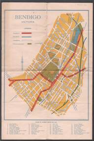
Map - BILL ASHMAN COLLECTION: MAP OF BENDIGO
Map of Bendigo. Contains street of Bendigo with Places of Interest marked, Map of the Bendigo Area with Places of Interest marked, and on the centre page is Bendigo the Golden Gateway to the North. There is a map with circles around Bendigo and their distance from centre Bendigo. Circles go to a distance of 20 miles. Information includes General Information, Scenic Attractions, Industrial Activities, Industries already Established, Sporting Facilities - Bendigo and District, and Cultural Organizations. JCI shield on the left under the map. Also some brief information about Bendigo.sciences, instruments - general, scalebuoy, bill ashman collection - correspondence, map of bendigo, cambridge press, a r mcconnachie, bendigo junior chamber of commerce, bendigo city council -
Bendigo Historical Society Inc.
Document - MARKS COLLECTION: PARISH PLAN OF WHITE HILLS
Sepia coloured map showing allotments in Parish of Sandhurst (White Hills) Written on LH side of map town and Suburban Lots White Hills Parish of Sandhurst. Scale is shown in chains. Surveyed by Horage Walker. Photo lithographed at the Department of Lands & Survey, Melbourne by J.Noone, Price 1/-. 6th. January 1865. Map shows Race Course Reserve at top of sheet, Municipal boundary is marked on LH side. Comments re vegetation throughout map. E.g poor soil timbered with Box scrub.bendigo, planning, white hills parish map -
 Kew Historical Society Inc
Map, MMBW, MMBW Plan No.39 Kew & Heidelberg, 1900-1910
The Melbourne and Metropolitan Board of Works (MMBW) was established by an act of the Victorian Parliament in 1890 to prepare for and to implement a sewerage and water reticulation system across what was then inner Melbourne, its surrounding and middle distance suburbs, including Kew. The MMBW was disbanded in 1991.The map collection of the Kew Historical Society has at its core the historic maps assembled and originally stored in the City Engineer's Department of the City of Kew. These include maps in a number of scales. The vast majority of maps were produced by the MMBW in the first two decades of the twentieth century, and are solid working maps, backed by linen for durability. These maps are historically significant to Kew, the City of Boroondara and to the history of the development of state utilities in Victoria. A number of the Kew maps have additional details added by former municipal officers, including the levels reached by various floods. As these were working documents, information was added to them long after the period of their initial production and distribution.Early map of part of the Borough of Kew, created in the first decade of the twentieth century, at a scale 160 ft to 1 inch. The map covers what was then the north western section of Kew, bordered on its north by Wills Street and the Kew Lunatic Asylum, in the west by the River Yarra [and the later added Yarra Boulevard] , by Princess Street in the East and Holroyd Street in the south. The map shows the extent of urban development by that time, prominent institutions and the outlines of built structures in the municipality. Contour lines were added in ink to the map at a later stage.MELBOURNE AND METROPOLITAN BOARD OF WORKS / PLAN NO. 39 / KEW & HEIDELBERGmelbourne & metropolitan board of works, mmbw maps, mmbw plans, borough of kew, cartography -
 Kew Historical Society Inc
Map, MMBW, MMBW Plan No.67 Kew, 1900-1910
The Melbourne and Metropolitan Board of Works (MMBW) was established by an act of the Victorian Parliament in 1890 to prepare for and to implement a sewerage and water reticulation system across what was then inner Melbourne, its surrounding and middle distance suburbs, including Kew. The MMBW was disbanded in 1991.The map collection of the Kew Historical Society has at its core the historic maps assembled and originally stored in the City Engineer's Department of the City of Kew. These include maps in a number of scales. The vast majority of maps were produced by the MMBW in the first two decades of the twentieth century, and are solid working maps, backed by linen for durability. These maps are historically significant to Kew, the City of Boroondara and to the history of the development of state utilities in Victoria. A number of the Kew maps have additional details added by former municipal officers, including the levels reached by various floods. As these were working documents, information was added to them long after the period of their initial production and distribution.Early map of part of the Borough of Kew, created in the first decade of the twentieth century, at a scale 160 ft to 1 inch. The map covers what was then the north central part of Kew, bordered on its north by the Outer Circle Railway Spruzen and Beresford Avenues, in the west by Princess Street, in the south by High Street, and in the east by (about) Belford Road. The map shows the extent of urban development by that time, prominent institutions and the outlines of built structures in the municipality. Contour lines were added in ink to the map at a later stage.MELBOURNE AND METROPOLITAN BOARD OF WORKS / PLAN NO. 67 / KEW melbourne & metropolitan board of works, mmbw maps, mmbw plans, borough of kew, cartography -
 Kew Historical Society Inc
Map, MMBW, MMBW Plan No.68 Kew, 1900-1910
The Melbourne and Metropolitan Board of Works (MMBW) was established by an act of the Victorian Parliament in 1890 to prepare for and to implement a sewerage and water reticulation system across what was then inner Melbourne, its surrounding and middle distance suburbs, including Kew. The MMBW was disbanded in 1991.The map collection of the Kew Historical Society has at its core the historic maps assembled and originally stored in the City Engineer's Department of the City of Kew. These include maps in a number of scales. The vast majority of maps were produced by the MMBW in the first two decades of the twentieth century, and are solid working maps, backed by linen for durability. These maps are historically significant to Kew, the City of Boroondara and to the history of the development of state utilities in Victoria. A number of the Kew maps have additional details added by former municipal officers, including the levels reached by various floods. As these were working documents, information was added to them long after the period of their initial production and distribution.Early map of part of the Borough of Kew, created in the first decade of the twentieth century, at a scale 160 ft to 1 inch. The map covers what was then the north central part of Kew, bordered in the north by Oak Avenue, in the west by the Yarra River and Connor's Creek, in the south by Beresford and Carnegie Avenues, and in the east by Glass's Creek and Burke Road. The map shows the extent of urban development by that time, prominent institutions and the outlines of built structures in the municipality. Contour lines and the levels of historic floods were added in ink to the map at a later stage.MELBOURNE AND METROPOLITAN BOARD OF WORKS / PLAN NO. 68 / KEW melbourne & metropolitan board of works, mmbw maps, mmbw plans, borough of kew, cartography -
 Eltham District Historical Society Inc
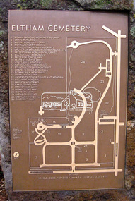
Photograph, Jim Connor, Eltham Cemetery, Mount Pleasant Road, Eltham, 2 Sep 2009
Guide map, Eltham CemeteryTomorrow's history documented todayeltham, jim connor collection, eltham cemetery -
 Kiewa Valley Historical Society
Maps - Bogong High Plains & Mt Beauty Township
The SECV continually updated their mapsDuring the development of the KHES the SECV had to continually update their mapsBoth Foolscap 1. Titled: High Plains Access Tracks & Roads 2. Mt Beauty Street Plan by SECV with Section Nos. and house numbersBoth have sticky tape marks on their back.khes maps -
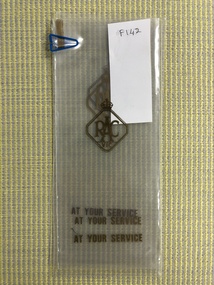 Robin Boyd Foundation
Functional object - Envelope
These were with some of the RACV maps.Plastic pamphlet covers (3), RACV -
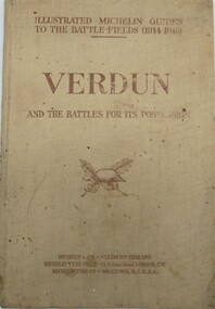 Ringwood RSL Sub-Branch
Book, Verdun and the Battles for its Possession, 1919
Maps and details of battles for VerdunSoft cover 116 pagesIllustrated Michelin guide