Showing 6500 items matching "move-werke"
-
 Eltham District Historical Society Inc
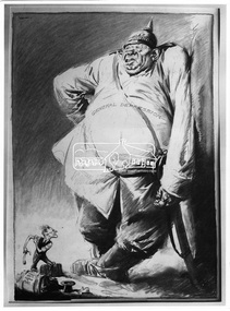
Photograph, Percy Leason, Cartoon "Goliath and the Prodical David", Percy Leason, 1931, 1931
This political cartoon depicts a black and white drawing; “General Depression”, a large ugly man wearing a German pike helmut, representing the Great Depression which Australians suffered from 1929 through the 1930s with a period of high unemployment, poverty, low profits, deflation, plunging incomes, and lost opportunities for economic growth and personal advancement. This figure overshadows a small man, representing Prime Minster James Scullin with a suitcase labelled “Jim S, London to Australia”. This is a reference to the PM’s decision to travel to London to seek an emergency loan and to attend the Imperial Conference (a meeting of Prime Ministers of the British Empire) He is holding a sling shot. The image has a “David and Goliath theme” denoting Australia as the underdog, a contest where a smaller, weaker opponent faces a much bigger, stronger adversary. The artist Percy Leason (1889 - 1959) was a painter and cartoonist renowned for his depictions of Australian society in the 1920s and 1930s. He lived in Eltham at his property 'Landscape' which he built in New Street (present day Lavender Park Road) from about 1924 to 1938 when he moved to the USA. In 1931 his cartoons were published in the Melbourne magazine “Table Talk” (although it cannot be confirmed that this one was). The original source of this image for the SEPP collection was the Publisher Thomas Nelson based in Melbourne. This photo forms part of a collection of photographs gathered by the Shire of Eltham for their centenary project book,"Pioneers and Painters: 100 years of the Shire of Eltham" by Alan Marshall (1971). The collection of over 500 images is held in partnership between Eltham District Historical Society and Yarra Plenty Regional Library (Eltham Library) and is now formally known as 'The Shire of Eltham Pioneers Photograph Collection.' It is significant in being the first community sourced collection representing the places and people of the Shire's first one hundred years.Digital image and 4 x 5 inch B&W Negsepp, shire of eltham pioneers photograph collection, percy leason, depression, cartoon, comic, james scullin, david and goliath, drawing, political cartoon -
 Eltham District Historical Society Inc
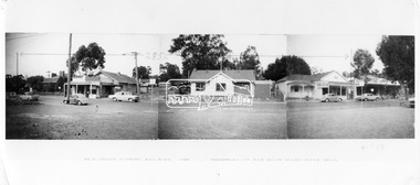
Negative - Photograph, Ian McDonald (Shire of Eltham), Main Road, between Arthur Street and Dudley Street, Eltham, 4 Jan. 1968
L-R: Former Shire Hall and Shire Office, Photographer shop, Barber shop, Fire Station, Hardware shop and Commercial Bank of Australia. Copied from an original document produced by Ian McDonald (Eltham Shire Council) 1970. During the period 1969-1971 photos were being collected for a proposed publication on the history of the Shire of Eltham as part of its centenary celebrations in 1971 (managed by the Shire of Eltham Historical Society and Alan Marshall). The publication was Pioneers & Painters (1971), edited by Alan Marshall. The document titled "Shows area sold to Woolworths" consisted of a panorama of three B&W photo prints creating a panorama of the frontage along Main Road (SEPP_0744) and a single B&W photo print of the Shire of Eltham offices and Hall on the corner of Arthur Street and Main Road (SEPP_0737) along with typed and hand written notes by Ian McDonald. The panorama (SEPP_0744) was captioned in typewritten text "Old Shire Office and Hall, etc - Frontage of 285 feet along Main Road" and in pencil the date "4-1-68" The single image of the shire offices (SEPP_0737) was captioned in typewritten text "Main Road and Arthur Street Corner" In addition, the following handwritten notes in pencil: " I took these photos from the new fire station - the building in the middle is the old fire station - Moved to Research for the Scouts 1970" and signed "IMcD"This photo forms part of a collection of photographs gathered by the Shire of Eltham for their centenary project book,"Pioneers and Painters: 100 years of the Shire of Eltham" by Alan Marshall (1971). The collection of over 500 images is held in partnership between Eltham District Historical Society and Yarra Plenty Regional Library (Eltham Library) and is now formally known as the 'The Shire of Eltham Pioneers Photograph Collection.' It is significant in being the first community sourced collection representing the places and people of the Shire's first one hundred years.Digital image 4 x 5 inch B&W Negsepp, shire of eltham pioneers photograph collection, eltham, main road, arthur street, dudley street -
 Kiewa Valley Historical Society
Timer Favag, Circa 1950
This Favag Timer apparatus was a part of the first electronic control system -(1960's), in Victoria), which worked using telephone stepping selectors to convey a change in voltage providing a regulated pulse from the control centre(Mount Beauty) to the remote Power Stations opening and closing (stop/start) of various devices at the Power Station and a return signal confirmed the action taken. Testing of this unit was carried out using a "dummy" device at the remote Power Station so as not to disrupt the power plant's operation. This timer was one of many electrical apparatus connected to the large SEC Victoria Hydro Scheme's electrical power producing generators. These generators are powered by the hydro force of "stored" water at a higher altitude. The establishment of both the NSW and Victorian Hydro Schemes was achieved from the early 1900's to the 1960's. At this point in time the need for additional power sources to quench both an industrial and domestic demand for electricity was purely an economic and not and environmental (carbon reduction) factor. This hydro scheme was instigated by "the Government of the day" as a bold move and was the major force of the World War II refugee and "technical" workforce,inclusion of skilled and unskilled, migration into the Australian environment. Although this mass "invasion" of workers with families was thought of in some circles as intrusive, the expansion of population post war years and its integration into the Australian rural sector, produced the multi- lingual multi-cultural diversity of later years.This Favag Timer was one of the crucial pieces of equipment that made it possible for the Mount Beauty Terminal Station to control the operations of these Power Stations; McKay, Clover, West Kiewa Power Stations and the Dederang Terminal Station.This aluminium and anodised "FAVAG" (pulse) timer is fastened to a base structure which comes with its own metal cover that is fastened by two metal hooks. From the top of these hooks runs a thick leather "carry" strap.The instrument, itself, a small "micro motor" at one end tape feeding spool on the other. Aluminium metal structures offer a preventative barrier against any electronic spikes from static electricity sources. There are two toggle switches to the bottom right hand side and twelve coloured "pin" connection points.There is a sliding access sleeve which exposes a circuit board.with various leads fastened on each side. In front of one of this slide are two "screw in" fuses, spare fuses are in a small envelope taped above. Circuit diagrams are etched white on black background on the top face of the main structure. At the base of the back section is a two pronged input terminal. There is a fine black rubber layer (cushioning) for the mian top cover.On the cover fastened with two rivets "FAVAG" underneath in small print "Fabrique d'appareils electriques S.A." underneathe "NEUCHATEL-SUISSE". on one end is a "STATE ELECTRICITY COMMISSION OF VICTORIA" metal label screwed on.The back label has manufacturers' type and model number.sec vic kiewa hydro scheme, alternate energy supplies, alpine population growth -
 4th/19th Prince of Wales's Light Horse Regiment Unit History Room
Medal
Title Peace of 1919 medalet issued to Australian schoolchildren Object type Medalet Place made Australia: Victoria, Melbourne Date made 1919 Summary Designed by C Douglas Richardson, 'The Peace of 1919' medalet was issued by the Defence Department to school children throughout Australia to commemorate the signing of the Versailles Peace Treaty in 1919. The medals were originally suspended from a narrow piece of red, white and blue striped cotton ribbon. This medalet is associated with one of the children of Lance Corporal Giles Daniel, 1st AIF. Born in Ballarat, western Victoria on 16 December 1870, Giles Felix Daniel moved to Oakleigh, Victoria aged 15. A member of the Victorian permanent forces, he served as a corporal (regimental number 8) with the First Victorian Mounted Infantry Company, part of the first Victorian Contingent to the war in South Africa in 1899. This unit was one of the first Australian formations to see action during the Boer War. It was largely drawn from serving members of the Victorian forces. Demoted to private following a Court Martial on 19 November 1900, Daniel returned to Australia in December of the same year. During the First World War, he was again one of the first to enlist, joining the AIF on 19 August 1914, and becoming Lance Corporal number 32 with the First Divisional Signals Company. He served with this unit during the Gallipoli campaign and until his return to Australia on 11 April 1916. Silver-plated brass Circular medalet with a plain edge and integral suspension loop. The obverse features a symbolic female figure of Peace, holding a sword and standing on a plinth marked 'PEACE 1919'. Behind her flies a dove, and at her left and right feet are two figures freed from their shackles. The reverse features a central panel surrounded by laurel leaves, surmounted by the King's Crown with the word 'VICTORY' over the rays of the rising sun. A sailor and a digger stand at ease on either side of the panel on which is cast 'THE / TRIUMPH / OF / LIBERTY / AND / JUSTICE'. Below the leaves is a very small panel with the words 'THE PEACE OF 1919' and the manufacturer's name.peace medal 1919 -
 Victoria Police Museum
Police Stations (Altona)
Altona is a suburb of Melbourne, 13 km south-west of Melbourne's CBD and located within the City of Hobsons Bay Altona Police Station opened as a temporary police station in 1919 in the Melbourne District. It was on the corner Sargood and Blyth Streets. It was staffed by one 1st Constable. The original police station was in a small room attached to the front of a 5-roomed weather-board dwelling with an iron roof on land measuring 66' x 165'. There was also a kitchen, vestibule, wash-house, office, one W.C. and a lock-up. In 1929 it became part of the Bourke District. On 31 March 1958 it moved into newly built government premises at 51-53 Blyth Street, on the corner of Bent Street. The building consisted of a cream brick veneer police residence and police station with cell. Staff was increased to a Sergeant in Charge and 3 Constables. A new police station was opened in Altona North on 7th October 1979. The Altona Police Station remained as a sub-station for a few a short time until the building was sold. July 2019 - a new police station is being constructed at 1 Galvin Street, Altona. Galvin Street was names after S/C Michael Arthur Galvin, 3651, who was appointed on 5 Jan 1886 and resigned on 4 Dec 1913. He was Werribee Shire President 1926-1927 and 1940-1941 8 black and white photos of new police station, 1963police stations; altona police station -
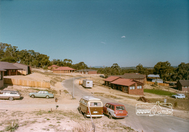
 Eltham District Historical Society Inc
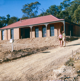
Document, 14 Stokes Place, Eltham: Building plans and contracts, 1979c
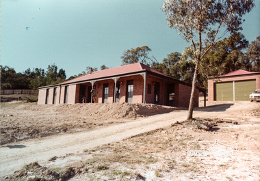
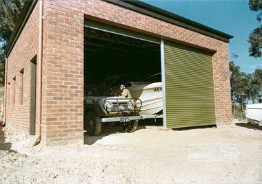
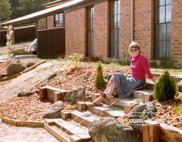
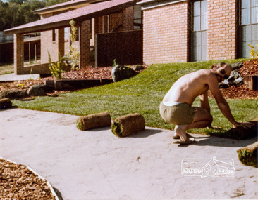
14 Stokes Place was the home of Peter and Carla Vermey. The land was purchased in May 1979 and the home built by Peter and Carla Vermey after the developer, Macquarie Builders went bankrupt. Sold October 2017 by Morrison and Kleeman Real Estate. Stokes Place was part of the Stokes Orchard Estate which was developed from the break-up of the the orchard owned by Frank Stokes who lived on the northeast corner of Nyora Road and Eucalyptus Road. His daughter Beryl advised that the Shire had levied a rate assessment on individual parcels of land within the orchard which became unaffordable resulting in its sub-division and sell off. The Stokes Orchard Estate was developed by Macquarie Builders in two stages starting with stage 1 in 1976. Stokes Place was part of Stage 2 in 1979. The Estate was bounded between Nyora Road, Eucalyptus Road, Diosma Road and Stokes Place. The original orchard only just reached the left most portions of Stokes Place and did not go fully up to Diosma, rather to just beyond the extant of Stokes Place. Stokes Place was known within the family as "The Oats" as that is where they grew oats. Frank Stokes moved to Eltham c.1945 after visiting Harold Bird to view his orchard, located diagonally opposite Stokes Orchard from the intersection of Eucalyptus Road, Pitt Street and Nyora Road. It was on Harold Bird's recommendation that Frank purchased the land.The Stokes Orchard Estate collection is typical of housing developments of the late 1970s and 1980s. It was one of the earliest estates in Eltham following the nearby Woodridge Estate development.Digital file30 digital files scanned from documents provided on loan by Peter and Carla Vermeystokes place, eltham, stokes orchard, stokes orchard estate, streets, houses, peter and carla vermey -
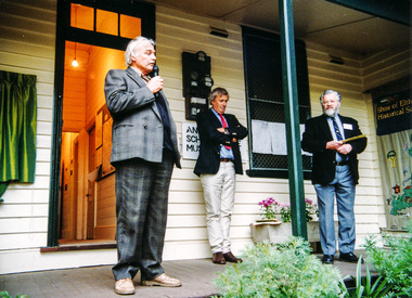 Eltham District Historical Society Inc
Photograph, Furphy Festival, Kangaroo Ground, 19 May 1996
The Andrew Ross Museum organised Kangaroo Ground’s 1851 – 1996 Furphy week-end which was held Friday May 17th to Sunday 19th May 1996. In commemoration of the district's links with the Furphy family, a plaque was unveiled at the front entry of the Andrew Ross Museum by Roger Furphy of the Furphy Foundary, Shepparton. The event was preceded by an address by author, Dr John Barnes of La Trobe University, the country’s leading authority on the novelist, Joseph Furphy. The date was seen as significant since it marked the 145th anniversary of the death of Judith, the young sister of John and Joseph Furphy, who died soon after commencing school in Kangaroo Ground 1851. Andrew Ross chronicled the event in his reminiscences. The most distinctive product to carry the Furphy brand would certainly be the water cart. The presence of the cart in military camps in Australia and overseas during the First World War led to the name of Furphy becoming an indelible part of our language and idiom. It was used extensively in Europe and the Middle East to carry water to the troops and the drivers of the carts were notorious sources of information and gossip for the men as they moved from camp to camp. As could be expected, not all their news was reliable and so it was that the word Furphy rapidly became a synonym for suspect information or rumour. Source: Kangaroo Ground Chronicle, Vol 1 No 2 Autumn 1996 Note the Shire of Eltham Historical Society Community Banner on display.Five colour photographsandrew ross museum, furphy festival, kangaroo ground -
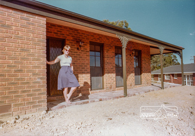
 Eltham District Historical Society Inc
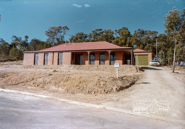
Photograph, 14 Stokes Place, Eltham, April 1980, 1980
14 Stokes Place was the home of Peter and Carla Vermey. The land was purchased in May 1979 and the home built by Peter and Carla Vermey after the developer, Macquarie Builders went bankrupt. Sold October 2017 by Morrison and Kleeman Real Estate. Stokes Place was part of the Stokes Orchard Estate which was developed from the break-up of the the orchard owned by Frank Stokes who lived on the northeast corner of Nyora Road and Eucalyptus Road. His daughter Beryl advised that the Shire had levied a rate assessment on individual parcels of land within the orchard which became unaffordable resulting in its sub-division and sell off. The Stokes Orchard Estate was developed by Macquarie Builders in two stages starting with stage 1 in 1976. Stokes Place was part of Stage 2 in 1979. The Estate was bounded between Nyora Road, Eucalyptus Road, Diosma Road and Stokes Place. The original orchard only just reached the left most portions of Stokes Place and did not go fully up to Diosma, rather to just beyond the extant of Stokes Place. Stokes Place was known within the family as "The Oats" as that is where they grew oats. Frank Stokes moved to Eltham c.1945 after visiting Harold Bird to view his orchard, located diagonally opposite Stokes Orchard from the intersection of Eucalyptus Road, Pitt Street and Nyora Road. It was on Harold Bird's recommendation that Frank purchased the land.The Stokes Orchard Estate collection is typical of housing developments of the late 1970s and 1980s. It was one of the earliest estates in Eltham following the nearby Woodridge Estate development.Digital fileScanned from a print contained in owner's photo album (81 prints in total digitised)stokes place, eltham, stokes orchard, stokes orchard estate, streets, houses, peter and carla vermey -
 Eltham District Historical Society Inc
Photograph, 14 Stokes Place, Eltham, April 1980, 1980
14 Stokes Place was the home of Peter and Carla Vermey. The land was purchased in May 1979 and the home built by Peter and Carla Vermey after the developer, Macquarie Builders went bankrupt. Sold October 2017 by Morrison and Kleeman Real Estate. Stokes Place was part of the Stokes Orchard Estate which was developed from the break-up of the the orchard owned by Frank Stokes who lived on the northeast corner of Nyora Road and Eucalyptus Road. His daughter Beryl advised that the Shire had levied a rate assessment on individual parcels of land within the orchard which became unaffordable resulting in its sub-division and sell off. The Stokes Orchard Estate was developed by Macquarie Builders in two stages starting with stage 1 in 1976. Stokes Place was part of Stage 2 in 1979. The Estate was bounded between Nyora Road, Eucalyptus Road, Diosma Road and Stokes Place. The original orchard only just reached the left most portions of Stokes Place and did not go fully up to Diosma, rather to just beyond the extant of Stokes Place. Stokes Place was known within the family as "The Oats" as that is where they grew oats. Frank Stokes moved to Eltham c.1945 after visiting Harold Bird to view his orchard, located diagonally opposite Stokes Orchard from the intersection of Eucalyptus Road, Pitt Street and Nyora Road. It was on Harold Bird's recommendation that Frank purchased the land.The Stokes Orchard Estate collection is typical of housing developments of the late 1970s and 1980s. It was one of the earliest estates in Eltham following the nearby Woodridge Estate development.Digital fileScanned from a print contained in owner's photo album (81 prints in total digitised)stokes place, eltham, stokes orchard, stokes orchard estate, streets, houses, peter and carla vermey -
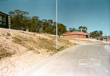
 Eltham District Historical Society Inc
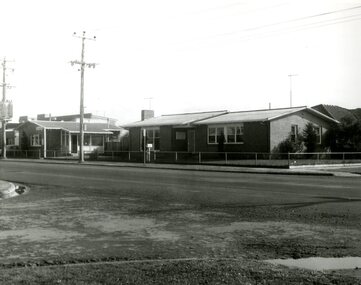
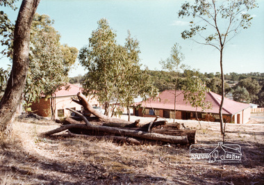
Photograph, Stokes Place, Eltham, April 1980; viewed from near no. 10 looking southeast, 1980
14 Stokes Place was the home of Peter and Carla Vermey. The land was purchased in May 1979 and the home built by Peter and Carla Vermey after the developer, Macquarie Builders went bankrupt. Sold October 2017 by Morrison and Kleeman Real Estate. Stokes Place was part of the Stokes Orchard Estate which was developed from the break-up of the the orchard owned by Frank Stokes who lived on the northeast corner of Nyora Road and Eucalyptus Road. His daughter Beryl advised that the Shire had levied a rate assessment on individual parcels of land within the orchard which became unaffordable resulting in its sub-division and sell off. The Stokes Orchard Estate was developed by Macquarie Builders in two stages starting with stage 1 in 1976. Stokes Place was part of Stage 2 in 1979. The Estate was bounded between Nyora Road, Eucalyptus Road, Diosma Road and Stokes Place. The original orchard only just reached the left most portions of Stokes Place and did not go fully up to Diosma, rather to just beyond the extant of Stokes Place. Stokes Place was known within the family as "The Oats" as that is where they grew oats. Frank Stokes moved to Eltham c.1945 after visiting Harold Bird to view his orchard, located diagonally opposite Stokes Orchard from the intersection of Eucalyptus Road, Pitt Street and Nyora Road. It was on Harold Bird's recommendation that Frank purchased the land.The Stokes Orchard Estate collection is typical of housing developments of the late 1970s and 1980s. It was one of the earliest estates in Eltham following the nearby Woodridge Estate development.Digital fileScanned from a print contained in owner's photo album (81 prints in total digitised)stokes place, eltham, stokes orchard, stokes orchard estate, streets, houses, peter and carla vermey -
 Eltham District Historical Society Inc
Photograph, 14 Stokes Place, Eltham, April 1980, 1980
14 Stokes Place was the home of Peter and Carla Vermey. The land was purchased in May 1979 and the home built by Peter and Carla Vermey after the developer, Macquarie Builders went bankrupt. Sold October 2017 by Morrison and Kleeman Real Estate. Stokes Place was part of the Stokes Orchard Estate which was developed from the break-up of the the orchard owned by Frank Stokes who lived on the northeast corner of Nyora Road and Eucalyptus Road. His daughter Beryl advised that the Shire had levied a rate assessment on individual parcels of land within the orchard which became unaffordable resulting in its sub-division and sell off. The Stokes Orchard Estate was developed by Macquarie Builders in two stages starting with stage 1 in 1976. Stokes Place was part of Stage 2 in 1979. The Estate was bounded between Nyora Road, Eucalyptus Road, Diosma Road and Stokes Place. The original orchard only just reached the left most portions of Stokes Place and did not go fully up to Diosma, rather to just beyond the extant of Stokes Place. Stokes Place was known within the family as "The Oats" as that is where they grew oats. Frank Stokes moved to Eltham c.1945 after visiting Harold Bird to view his orchard, located diagonally opposite Stokes Orchard from the intersection of Eucalyptus Road, Pitt Street and Nyora Road. It was on Harold Bird's recommendation that Frank purchased the land.The Stokes Orchard Estate collection is typical of housing developments of the late 1970s and 1980s. It was one of the earliest estates in Eltham following the nearby Woodridge Estate development.Digital fileScanned from a print contained in owner's photo album (81 prints in total digitised)stokes place, eltham, stokes orchard, stokes orchard estate, streets, houses, peter and carla vermey -
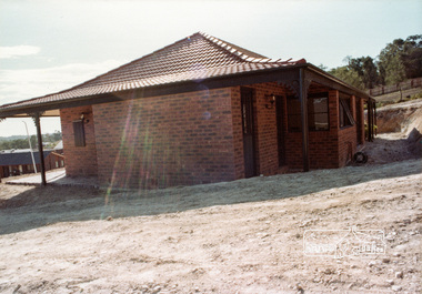
 Eltham District Historical Society Inc
Photograph, 14 Stokes Place, Eltham, April 1980, 1980
14 Stokes Place was the home of Peter and Carla Vermey. The land was purchased in May 1979 and the home built by Peter and Carla Vermey after the developer, Macquarie Builders went bankrupt. Sold October 2017 by Morrison and Kleeman Real Estate. Stokes Place was part of the Stokes Orchard Estate which was developed from the break-up of the the orchard owned by Frank Stokes who lived on the northeast corner of Nyora Road and Eucalyptus Road. His daughter Beryl advised that the Shire had levied a rate assessment on individual parcels of land within the orchard which became unaffordable resulting in its sub-division and sell off. The Stokes Orchard Estate was developed by Macquarie Builders in two stages starting with stage 1 in 1976. Stokes Place was part of Stage 2 in 1979. The Estate was bounded between Nyora Road, Eucalyptus Road, Diosma Road and Stokes Place. The original orchard only just reached the left most portions of Stokes Place and did not go fully up to Diosma, rather to just beyond the extant of Stokes Place. Stokes Place was known within the family as "The Oats" as that is where they grew oats. Frank Stokes moved to Eltham c.1945 after visiting Harold Bird to view his orchard, located diagonally opposite Stokes Orchard from the intersection of Eucalyptus Road, Pitt Street and Nyora Road. It was on Harold Bird's recommendation that Frank purchased the land.The Stokes Orchard Estate collection is typical of housing developments of the late 1970s and 1980s. It was one of the earliest estates in Eltham following the nearby Woodridge Estate development.Digital fileScanned from a print contained in owner's photo album (81 prints in total digitised)stokes place, eltham, stokes orchard, stokes orchard estate, streets, houses, peter and carla vermey -
 Eltham District Historical Society Inc
Photograph, 14 Stokes Place, Eltham, 1982, 1980
14 Stokes Place was the home of Peter and Carla Vermey. The land was purchased in May 1979 and the home built by Peter and Carla Vermey after the developer, Macquarie Builders went bankrupt. Sold October 2017 by Morrison and Kleeman Real Estate. Stokes Place was part of the Stokes Orchard Estate which was developed from the break-up of the the orchard owned by Frank Stokes who lived on the northeast corner of Nyora Road and Eucalyptus Road. His daughter Beryl advised that the Shire had levied a rate assessment on individual parcels of land within the orchard which became unaffordable resulting in its sub-division and sell off. The Stokes Orchard Estate was developed by Macquarie Builders in two stages starting with stage 1 in 1976. Stokes Place was part of Stage 2 in 1979. The Estate was bounded between Nyora Road, Eucalyptus Road, Diosma Road and Stokes Place. The original orchard only just reached the left most portions of Stokes Place and did not go fully up to Diosma, rather to just beyond the extant of Stokes Place. Stokes Place was known within the family as "The Oats" as that is where they grew oats. Frank Stokes moved to Eltham c.1945 after visiting Harold Bird to view his orchard, located diagonally opposite Stokes Orchard from the intersection of Eucalyptus Road, Pitt Street and Nyora Road. It was on Harold Bird's recommendation that Frank purchased the land.The Stokes Orchard Estate collection is typical of housing developments of the late 1970s and 1980s. It was one of the earliest estates in Eltham following the nearby Woodridge Estate development.Digital fileScanned from a print contained in owner's photo album (81 prints in total digitised)stokes place, eltham, stokes orchard, stokes orchard estate, streets, houses, peter and carla vermey -
 Eltham District Historical Society Inc
Photograph, 14 Stokes Place, Eltham, October 1983, 1980
14 Stokes Place was the home of Peter and Carla Vermey. The land was purchased in May 1979 and the home built by Peter and Carla Vermey after the developer, Macquarie Builders went bankrupt. Sold October 2017 by Morrison and Kleeman Real Estate. Stokes Place was part of the Stokes Orchard Estate which was developed from the break-up of the the orchard owned by Frank Stokes who lived on the northeast corner of Nyora Road and Eucalyptus Road. His daughter Beryl advised that the Shire had levied a rate assessment on individual parcels of land within the orchard which became unaffordable resulting in its sub-division and sell off. The Stokes Orchard Estate was developed by Macquarie Builders in two stages starting with stage 1 in 1976. Stokes Place was part of Stage 2 in 1979. The Estate was bounded between Nyora Road, Eucalyptus Road, Diosma Road and Stokes Place. The original orchard only just reached the left most portions of Stokes Place and did not go fully up to Diosma, rather to just beyond the extant of Stokes Place. Stokes Place was known within the family as "The Oats" as that is where they grew oats. Frank Stokes moved to Eltham c.1945 after visiting Harold Bird to view his orchard, located diagonally opposite Stokes Orchard from the intersection of Eucalyptus Road, Pitt Street and Nyora Road. It was on Harold Bird's recommendation that Frank purchased the land.The Stokes Orchard Estate collection is typical of housing developments of the late 1970s and 1980s. It was one of the earliest estates in Eltham following the nearby Woodridge Estate development.Digital fileScanned from a print contained in owner's photo album (81 prints in total digitised)stokes place, eltham, stokes orchard, stokes orchard estate, streets, houses, peter and carla vermey -
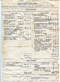 Orbost & District Historical Society
account, 30th June 1891
The first Presbyterian Church service was conducted at the Orbost Station Homestead in 1885, during a visit by Sir William Clarke, who was accompanied by two ministers. The organist was resident Grace Jennings Carmichael. Services were later held in Mr J. W. Borland’s shop and the Mechanics Hall. In 1887 the land on which the church now stands was purchased from Mr James Hossack snr, for £50 ($100). The trustees were Mr John, Peter and Hugh Cameron, Mr John A Watt and Mr James Hossack Jnr. Timber from Richardson’s Tabbara Mill was used by builder Mr R. P Cameron and at a cost of £ 311.3.7 ($622) the church was opened January 9th 1898. This item is from the estate of Elsie Cooke. Elsie Cooke was a librarian in Orbost for many years. She was the daughter of John Cooke early Brodribb settler. Elsie Cooke lived all her life in Gippsland,. She was born at Brodribb in 1895 and died in 1970, Elsie Cooke lived at Bruthen for a short time and, in 1937, moved to live with her aunt, Miss Jean Munro. Miss Cooke was Librarian at the Mechanics Institute for many years. Kindness and consideration for other were Miss Cooke’s attributes and she endeared herself to all who knew her. She was a loyal member of the Presbyterian Church and a stalwart of the Ladies’ Guild, an energetic worker for the Municipal Auxiliary and a member of the Red Cross. (ref. Mary Gilbert This item is associated with the Presbyterian Church in Orbost. It is an example of early book-keeping and is also associated with Elsie Cooke.Two white paper accounts. They are typed in black and are statements of receipts and expenditure for the Presbyterian Church in Orbost. On one sheet is an alhabetical list of subscribers for the year ending June 30, 1891. On the other is a general account of receipts and expenditure.presbyterian-church-orbost account-book-keeping -
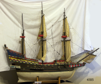 Flagstaff Hill Maritime Museum and Village
Craft - Ship model, Golden Hind
This is a ship model of the famous galleon the "Golden Hind". About the “Golden Hind” The English galleon “Golden Hind”, a mid-16th century Elizabethan warship, was launched in 1577. It was formerly known as the “Pelican”. The Golden Hind was the flagship of Captain Sir Frances Drake, in which he became the first Englishman to circumnavigate the world 1577-1580. Tonnage 100-150 tons Displacement 300 tons [fully loaded] Speed 8-15 knots Armament 22 guns Crew 80 sailors, 10 officers Built Aldeburgh, Suffolk, then moved to Plymouth, Devon in 1576 Type of ship Galleon; multi-decked ship (5 decks), square rigged, 3 masted sailing ship Estimated size Length - 70 feet (21.3m); Breadth – 19 feet (5.8m); Depth – 9 feet (2.7m) The Pelican set sail in 1577 on an expedition sponsored partly by Queen Elizabeth and Sir Christopher Hatten (whose family crest was a golden hind). His companion ships were the Swan, Marigold, Benedict and the Elizabeth. During this voyage, in 1578, Drake renamed the Pelican as the Golden Hind in honour of is patron. Sir Francis Drake [1544 – 1596] brought the Golden Hind home from his circumnavigation of the globe with looted gold, percelain, jewels and cash worth 35,000,000 million pounds in today’s money. It was the largest treasure every captured at that date. Only two ships returned – the “Golden Hind” and the “Elizabeth”. The ship model of the Golden Hind captained by Sir Frances Drake represents the first English circumnavigation of the globe.Ship model of the16th century galleon "The Golden Hind", Sir Francis Drake’s flagship (not in a glass case.) flagstaff hill, warrnambool, shipwrecked coast, flagstaff hill maritime museum, maritime museum, shipwreck coast, flagstaff hill maritime village, great ocean road, ship model, model ship, galleon golden hind 1577, galleon golden hinde 1577, galleon pelican 1577, 16th century galleon, 16th century warship, sir frances drake, captain frances drake, first englishman to circumnavigate the globe -
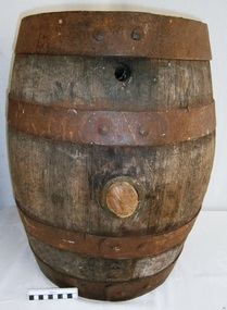 Flagstaff Hill Maritime Museum and Village
Container - Barrel, 19th century
This small barrel looks well used. Unfortunately, the inscription on the barrel is indecipherable so its story is a mystery. However, the bungholes on the side are a clue that it was once used for storing liquid, likely to have been liquor. Barrels have been used over many centuries for transporting and storing a wide range of dry and liquid goods. They are made by tradesmen called coopers, who use heat and steam to bend and shape the wood to suit the work in hand. They add metal reinforcing, handles, spouts and suchlike, to complete they process. Their produce also includes buckets, casks and tubs. Ships transported bulk liquor in their cargo, stored in wooden barrels. The barrels' round shape allowed them to be easily moved by rolling them into place. The body's shape gave the barrels added strength and the iron bands helped the wooden sheaves stay in place. The tops and bottoms allowed for easy grip. The bungholes gave access to government representatives, who would sample the contents, measure the alcohol percentage, and charge the appropriate duty or tax; the process was called Ullaging and the instrument they used was a Hydrometer. Hundreds of barrels of cement were imported into Warrnambool in the late 19th century for the construction of the Warrnambool Breakwater. Barrel-shaped concrete blocks are still visible at shipwreck sites such as on the LOCH ARD wreck, which carried cement among its cargo.This small barrel is representative of 19th century containers used for transportation and storage of liquid such as liquor. It is a historic shape that is still used in modern times.Barrel; wooden barrel, cylindrical shape with metal bands or ribs for reinforcement. The side has two bungholes; one has a bung or stopper. Inscription on top (indecipherable). (indecipherable)flagstaff hill, warrnambool, shipwrecked-coast, flagstaff-hill, flagstaff-hill-maritime-museum, maritime-museum, shipwreck-coast, flagstaff-hill-maritime-village, barrel, cask, small barrel, trade, coopering, cooper, casket, transport, storage, bunghole -
 Federation University Historical Collection
Letter - Correspondence, S.C. McBride, Letter concerning the work of Pastor Doug Nicholls and the Aborigines Advancement League, 1958, 11/07/1958
The Church Men's Society was a part of the Church of Christ in Peel Street, Ballarat. In 1958 the President was C. Thomas, and S.C. McBride was Secretary. The Aborigines Advancement League (also known as the Aboriginal Advancement League) claims to be the oldest Aboriginal organisation in Australia. It is primarily concerned with Aboriginal welfare issues and the preservation of Aboriginal culture and heritage, and is based in Melbourne. The League was established in 1957 as a response to an enquiry by retired magistrate, Charles McLean, into the circumstances of Aboriginal Victorians. McLean was critical of conditions in the Lake Tyers and Framlingham Aboriginal Reserves. McLean recommended that persons of mixed Aboriginal and European descent be removed from the reserves. The people of Lake Tyers objected to this, and the League was formed out of their campaign. The new League drew from two already existing organisations, the Australian Aborigines League, established 1934 and the Save the Aborigines Committee, which had been established in 1955 as a response to the Warburton Ranges crisis. Founding President of the League was Gordon Bryant, with Doris Blackburn as Deputy President, Stan Davey as Secretary and Douglas Nicholls as Field Officer. Early activities included lobbying for a referendum to change the Australian constitution to allow the Federal government to legislate on Aboriginal affairs, and an establishing a legal defence fund for Albert Namatjira, after he was charged with supplying liquor to an Aboriginal ward.[1] By 1967 it had moved to being fully controlled by Aboriginal people with Bill Onus as the first Aboriginal President.Typed letter on Church Men's Society (C.M.S.) letterhead. The letter concerns a film 'showing the tragic condition of aborigines in Central Western Australia ...' The C.M.S. (Ballarat) planned to hold a public meeting in Ballarat at which Pastor Doug Nicholls, M.B.E. will speak and screen the film. doug nicholls, c. thomas, aborigines, ballarat town hall, stan davey, s.c. mcbride, letterhead -
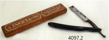 Flagstaff Hill Maritime Museum and Village
Functional object - Razor and case, E.M. Dickinson, 1895-1930
E M Dickinson was a cutlery company in Sheffield that made all types of cutlery knives of all types and patterns, razors domestic electroplated cutlery etc. Edwin Murray Dickinson started recruiting workers for his new cutlery firm at 11 Cambridge Street Sheffield England in 1870. The original premises consisting of warehouse, offices, cutlers shops fitted with the latest steam-powered equipment however this premises was offered for let in November 1887, and new premises were secured at 51 Division Street and were occupied by Dickinson's in early 1888. By October 1890 Dickinson was advertising the Division Street premises to let and moved the company into other new works (still called Murray Works) at 122 Rockingham Street. On 12th October 1901, Dickinson gave notice that the firm was to be converted to a limited company and by March 1908 the Rockingham Street works had been advertised for sale. In 1909 the deeds for other new premises at 203 Arundel Street Sheffield were deposited to secure a £3,000 loan from the Sheffield Banking Company. Then on Christmas Eve 1926 several hundred pounds worth of damage was caused by a fire at the Arundel Street works. The founder, Edwin Dickinson died on 21st October 1930 aged 81 at his home at 449 Crookesmoor Road and on the 23rd May 1939 the firm went into voluntary liquidation.An item made by a company that made many different types and patterns of cutlery for domestic use and export.Straight razor with black celluloid handle and it’s boxBlade has marking, INVICTA" with decorative engraved design, on the other side engraved "E M DICKINSON SHEFFIELD ENGLAND"flagstaff hill, warrnambool, flagstaff-hill, flagstaff-hill-maritime-museum, shipwreck-coast, flagstaff-hill-maritime-village, razor, e m dickinson ltd, e m dickinson ltd sheffield england., cut throat razor, cutlery -
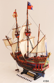 Flagstaff Hill Maritime Museum and Village
Craft - Ship Model, Golden Hind
This is a ship model of the Golden Hind. About the “Golden Hind” The English galleon “Golden Hind”, a mid-16th century Elizabethan warship, was launched in 1577. It was formerly known as the “Pelican”. The Golden Hind was the flagship of Captain Sir Frances Drake, in which he became the first Englishman to circumnavigate the world 1577-1580. Tonnage 100-150 tons Displacement 300 tons [fully loaded] Speed 8-15 knots Armament 22 guns Crew 80 sailors, 10 officers Built Aldeburgh, Suffolk, then moved to Plymouth, Devon in 1576 Type of ship Galleon; multi-decked ship (5 decks), square rigged, 3 masted sailing ship Estimated size Length - 70 feet (21.3m); Breadth – 19 feet (5.8m); Depth – 9 feet (2.7m) The Pelican set sail in 1577 on an expedition sponsored partly by Queen Elizabeth and Sir Christopher Hatten (whose family crest was a golden hind). His companion ships were the Swan, Marigold, Benedict and the Elizabeth. During this voyage, in 1578, Drake renamed the Pelican as the Golden Hind in honour of is patron. Sir Francis Drake [1544 – 1596] brought the Golden Hind home from his circumnavigation of the globe with looted gold, percelain, jewels and cash worth 35,000,000 million pounds in today’s money. It was the largest treasure every captured at that date. Only two ships returned – the “Golden Hind” and the “Elizabeth”. This Ship model of the galleon Golden Hind, the flagship of Captain Sir Frances Drake, represents the first circumnavigation of the globe by an Englishman.Ship model, the galleon Golden Hind on timber stand. Square rigged with 2 masts each with a flag and crow's nest. 22 guns on decks. Brown hull with green stripes and decorative coloured trimmings. Nameplate "Sir Francis Drake - his ship / The Golden Hind - 1577-1580". Emblem with animal golden hind, Tudor Rose and lamp above. Nameplate "Sir Francis Drake - his ship / The Golden Hind - 1577 - 1580"flagstaff hill, warrnambool, shipwrecked-coast, flagstaff-hill, flagstaff-hill-maritime-museum, maritime-museum, shipwreck-coast, flagstaff-hill-maritime-village, ship model, model ship, galleon golden hind 1577, galleon golden hinde 1577, galleon pelican 1577, 16th century galleon, 16th century warship, sir frances drake, captain frances drake, first englishman to circumnavigate the globe -
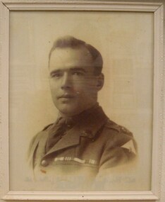 Red Cliffs Military Museum
Framed Photograph, Lieutenant W.T. West, MM, MC, (estimated)
1789 Corporal Walter Thomas West was recommended for Military Medal 13th May 1917. Citation: For conspicous gallantry in action at the Hindenburg Line on 3rd May 1917. When he attacked with few bob=mbers an enemy post using MG fire against the right brigade. Having taken up the post he moved down the first trench and with 6 men engaged an enemy party who were resisting the 2nd attack of the tight brigade. Recommended by GOC 6th Australian Infantry Brigade. Lieutenant Walter Thomas West was recommended for MC 21st Ocrober 1918. Citation: During the attack on Montebrehain, east of Peronne on 5th Ocober, 1918, Lt West acted in a skilful and courageous manner when his platoon was held up by an enemy strong post, he rushed forward alone under heavy machine gun fire, threw a bomb at the post and captured the gun and crew of three. Later his flank was being held up by a strong post manned by the German guns in cemetary. Lt. West crawled round to the right and rushed the post. One ran he killed 3 of the nemy and took 3 prisoners. The men in the other post ran off with their gun and so escaped. Throughout the day he led his platoon with skil and when the company commander was killed assumed charge and supervised the consolidation of the line with great activity and courage. A framed black and white photgraph of Lieutenant West in dress uniform, showing Unit Insignia (colour Flash) service ribbons.Photo clearly shows unit insignia, ranks pips, service and valour ribbons.of, 1919, australia, 1917, ww1, commonwealth, gazette, london, walter, thomas, west, mm, mc, page, 2, collection, july, w t west, gazettte, 9, location, 6839, 8th, nov, 2937, position, 104, april, 4337, 12, 23, 1163, 45 -
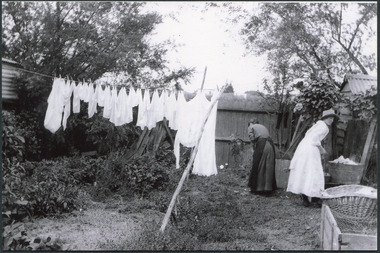 City of Moorabbin Historical Society (Operating the Box Cottage Museum)
Photograph - Washing Day at 'Law Muir Den' Mrs J L Smith c1910, c1910
Mrs J.L.Smith and Ada Smith in the backyard of the house Law Muir Den 510 Centre Rd Bentleigh c 1910. . The early settler women usually devoted a whole day to washing as it was very labourious. A fire was lit in a stone pit and a large tub of water boiled. Soap that had been made, usually in the previous Autumn, from fat drippings and caustic soda, was flaked into the tub to form suds. The clothes were moved around in the tub with a long wooden paddle that was also used to lift the clothes out of the tub into another tub of cold rinsing water..Stains were removed by scrubbing soap on the cloth against a scrubbing board. Clothes were wrung by hand or a mechanical wringer and hung on the clothes line to dry. Mary Ann Smith was married John Logan Smith 1860-1932 who at first rented a cottage 'Law Muir Den' & Shed from Mr Box and commenced business as a wood merchant - sawing logs into shorter pieces using one horse to power the saw. He purchased the property, added to the buildings , began trading in fuel and fodder as well and installed a chaff cutting mill powered by 10hp steam engine. The business prospered As Motor transport was increasing 1926 J L Smith built a small Garage on the opposite corner (Woolworths Supermarket 2005) , employed a good mechanic ( Reg Hunt ) and developed another successful business. J.L.Smith was an early settler in East Brighton now Bentleigh and established successful Wood cutting, Grain & Chaff cutting and Motor garage businesses in Centre Road . He was elected Councillor of the Shire of Moorabbin and, with Mary Ann, his family were involved with local Church, Red Cross, and other community organizations.Photograph, Black & White, showing 2 women washing clothes in a large tub, set over a fire in a stone pit, in the back yard. Clothes are hanging from a rope line strung between 2 trees and held up with a wooden 'prop'