Showing 7090 items matching "snowy-river"
-
 Greensborough Historical Society
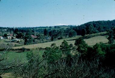
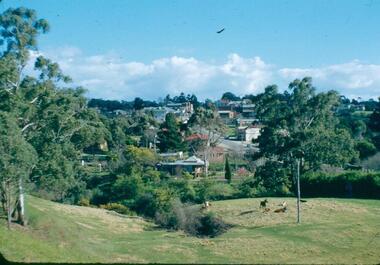
Photograph - Digital image, Frank Robinson, Looking north from the top orchard of Blackjack, 1954_
Looking north from the top orchard of Blackjack. The Blackjack property, house and acres of fruit orchards ran down to the Plenty River off Hume Street Greensborough and was the home of the Robinson family to late 1956. The photographs were taken as slides by Frank Robinson and digitised by his son James in 2015.Digital copy of colour photograph.blackjack, robinson family -
 Kiewa Valley Historical Society
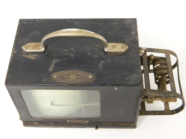
Barometer Anoroid, circa mid to late 1900's
This barometer was part the hydrology and forestry groups working within the SEC Vic Hydro Scheme from the initial appraisal review long before any construction began in the 1940's. The river flows and rainfall patterns had to be established before any construction of holding dams or tunneling could commence. This barometer is very relevant to the Kiewa Valley history because it presents the high degree of professional and technical information required at the time before implementing the "Scheme" upon the virgin alpine region and its effects upon the "natural" flows of the rivers within the Kiewa Valley. Time since the start of the project has verified the use of instruments such as this barometer and the information gained from its use that the success of any large impact upon a sensitive environment requires a thorough and systematic study before implementation. Weather records were kept of temperature, wet-bulb temperature, wind direction, speed and barometric pressures. To record barometric pressure a meter was devised with a clockwork mechanism which took one week to do a revolution. A chart was fitted to a drum and had an ink pen shaped like a little shovel. The shovel was filled with ink and was checked daily. To calibrate the barometer it was sent to the Melbourne General Post Office to be compared against the one there (at sea level). After calibration it was sent back to the Bogong Camp.On plaque on top side."NEGRETTI & ZAMBRA" underneath this and in smaller print "TRADE MARK" below this "LONDON" On the bottom and in small print "HOBART DUFFPty Ltd COLLINS HOUSE MELBOURNE C1"kiewa hydro electricity scheme, victorian state electricity commission, transformers, resistors, barometers -
 Orbost & District Historical Society
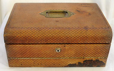
writing desk, before 1888
This was presented to Mr A.D. Munro by the residents of Orbost on his retirement as postmaster in 1888. In 1883 the mail terminus was at Newmerella. In July 1883 it was extended to the north side of the river and Archie Munroe became Acting Post Master. He was Post Master until 1885 when the telegraph line came to Orbost.Archie Munro was a well-known Orbost identity who first operated a boot shop in Cameron's barn. He was also active in the promotion of the first brass band in Orbost. He was the son of Hector Munro.A large brown leather portable writing desk. It has a brass handle on the top. Inside are copies of some Munro family documents in a document folder.On a brass plate-Presented to Mr A.B. Munro by the RESIDENTS OF ORBOST on his retirement as Post Master. A.D. 1888munro-archie writing-desk post-office -
 Melbourne Tram Museum
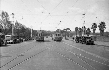
Negative - Batman Ave terminus, Wal Jack collection, 1936
Photograph of W2 310 (route 77) and CW5 681 (route 74) in Batman Ave with the crossovers in the foreground and Yarra river in the background. The 3rd tram arriving appears to be Y 469. May not be a Wal Jack photograph as odd negative size. No photographer details on the rear of the print though dated 1936.Yields information about the Batman Ave tram terminus.Black and white negative, by Wal Jack and copy print with details written on the rear.trams, tramways, batman ave, route 74, route 77, tram 310, tram 681, cw5 class, w2 class, mmtb -
 The Beechworth Burke Museum
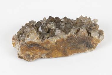
Geological specimen - Smoky quartz crystals, unknown
Quartz is an extremely common mineral to find across the world. Quartz can have two forms; Microcrystalline quartz or Crystalline quartz. Microcrystalline quartz is a fine grain quartz where crystalline quartz is often a large crystal. This specimen is a crystalline quartz. Made of silicon oxide, this specimen is called smokey quartz crystals because of its brownish colour. However, the colour of quartz can vary. In addition, quartz are formed in deep-seated igneous rocks and crystallized through hot aqueous solutions. This type of crystal can be found all over Australia, including Beechworth in Victoria. Other places quartz can be found is the Ashburton River area in Western Australia, Marlborough in Queensland, the Lune River area in Tasmania and Kingsgate in New South Wales. This specimen is significant because it is common to find this kind of mineral. While the location of where this specimen was originally from is unknown, it highlights the many places in Australia where quartz is found. It demonstrates that quartz makes up a large portion of Australia's geology. In addition, quartz itself can vary in its colour and shape. This specimen represents one of these variations. That being smoky quartz crystals. This specimen is part of a larger collection of geological and mineral specimens collected from around Australia (and some parts of the world) and donated to the Burke Museum between 1868-1880. A large percentage of these specimens were collected in Victoria as part of the Geological Survey of Victoria that begun in 1852 (in response to the Gold Rush) to study and map the geology of Victoria. Collecting geological specimens was an important part of mapping and understanding the scientific makeup of the earth. Many of these specimens were sent to research and collecting organisations across Australia, including the Burke Museum, to educate and encourage further study.A large hand-sized quartz mineral with shades of brown and gray throughout.Smoky quartz / crystals /locality/ unknown / (needs a wash) /BBgeological specimen, geology, geology collection, burke museum, beechworth, microcrystalline, quartz, quartz mining, quartz reefs beechworth, smokey quartz crystals, crystals, crystalline, silicon oxide, brown, colour, igneous rocks, magma, ashburton river, western australia, marlborough, queensland, lune river, tasmania, kingsgate, new south wales, nsw -
 Greensborough Historical Society
Photograph, Main Road bridge looking to township of Greensborough, 1929c
View of Main Street Greensborough from Partington's Hill including Plenty River bridge and Marble Hall on corner of Carter Street (now Para Road) and Main Street. This view of Greensborough Park shows the old pan toilets, the hawthorn fence line and the rather undeveloped roadside area of the park. Looking up Main Street we see the old Chapman house at the corner of Poulter Avenue and some newer houses below this. The stone river bridge appears to be only a single lane wide and the road approaching the bridge is unsealed. The rail bridge shows evidence of soot from steam trains and at the extreme left of picture the two concrete buildings indicate the line had been electrified. This occurred in 1923. Sparse housing is seen in the Flintoff Street and Grimshaw Street area.Part of a collection of photographic enlargements of views of Greensborough in the early 1900s.Black and white enlargement of photographic imagemain street greensborough, marble hall, greensborough railway, chapman house, greensborough park, poulter avenue greensborough, carter street, para road -
 Eltham District Historical Society Inc
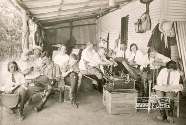
Photograph, Bend of Islands, c.1926
Bend of Islands is named after a group of small islands at a bend of the Yarra River near Watsons Creek. It is located near the town of Kangaroo Ground. The locationn was a long time favourite spot for locals and visitors to fish and swim in the river. This is one of a series of four photographs that depict a mainly young group of people recreating in the area, particularly enjoying horse riding. Possibly weekend campers. Photos taken about 1926-1928. In 1938 "The Argus" advertised weekend cabins at the Bend of Islands estate 5-are Yarra Yarra frontage in the Christmas Hills Gorge ideal for weekend cabins. "Bathing, fishing, canoeing, shooting may be enjoyed in ideal surroundings". Was this a church group? This photo depicts individuals "resting" on a verandah undertaking various solo activities including listening to their gramophone.Black and white photograph (reproduction)Bend of Islands, c.1926 bend of islands, camping, recreation, gramophone, group, campers -
 Orbost & District Historical Society
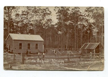
black and white photograph, 1908
This item is part of the Mary Gilbert Collection. Noorinbee School, situated on the Bombala Rd approximately 6.5 km north of Cann River, was opened on 26th of July 1900, with Albert Le Page as head teacher until 30th of September 1904. The school no longer functions. A school bus would daily to take the older children to the central classes at Cann River. "Noorinbee" is an Aboriginal word of unknown origin, The historical school is still at the front of the school yard. The Old Noorinbee School was been shifted twice. The first time they used a bullock team in 1924. The second time they used trucks and tractors in 1991. It was the first public building for the Cann Valleyand was first used as a hall and a church until it became the Noorinbee school in 1900. It was built in 1898.This item is associated with education in East Gippsland. It is also associated with the Gilbert family.A black / white photograph / postcard which has a letter written on the back. On the front is a small wooden building, a shed on the right, a wooden fence at the front with children scattered in the yard.on front - "State School No 3372" on back - " Mrs J. Gilbert Talangoota, Orbost"gilbert-annie noorinbee-state-school education-east-gippsland -
 National Wool Museum
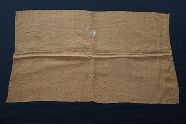
Textile - Quilt, Wheat Bag Wagga, Percy Perkins, 1945
Mr Perkins joined the police force in his early twenties and apart from an 18-month posting in Melbourne, spent the rest of his career serving communities in country Victoria. He was a keen fisherman and hunter- his first love was sitting on the banks of the Murray River with a fishing rod in his hand. Family camping trips were spent by the river where everyone slept on stretchers with several army blankets underneath and a wheat bag wagga on top. This wagga is made from two standard sized jute wheat bags split and hand bound along the seams. It is typical of a basic wagga made by shearers, farmers and swagmen. The paint stains on this wagga display signs of later use as a painting drop sheet by descendants who inherited the quilt. Quilt made of two standard size jute wheat bags (a bushel = 150lbs) split and hand bound along seams. It is an example of the basic type of wagga made by shearers, farmers or swagmen. Another use for the wagga was as a 'drop sheet' when doing house painting- possibly explaining the paint stains on the wagga.quilting history, running stitch group, running stitch collection, highlights of the national wool museum: from waggas to the wool quilt prize - exhibition (22/09/2001 - 02/12/2001), perkins, mr percy, quilting - history -
 National Wool Museum
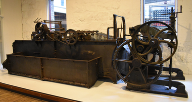
Machine - Scouring Bowl, J Dyson & Sons Pty Ltd, c.1890
Scouring is the process that removes wool wax and other unwanted products from wool. Wool is washed in a hot detergent solution. It moves through a series of scouring bowls and is then rinsed and dried. Careful handling and washing preserves the strength and softness of wool. If the wool contains lots of seeds and other vegetable matter, it must be cabonized. This means it is treated with a solution of sulpheric acid and then baked at high temperature to remove impurities. The disused scouring water left-over from this process was often let drain into rivers and watercourses causing pollution. Many of Geelong's wool scours along the Barwon River were closed due to environmental damage. The race system on this bowl is not the original it has been modified with a variation of the harrow system. Used at E.P. Robinson South Geelong from c.1890-1970.Scouring bowl.J. Dyson & Sons Pty Ltd, Geelongsouring bowl, j dyson & sons, geelong, wool processing, e. p. robinson, textile industry, factory, mill -
 Greensborough Historical Society
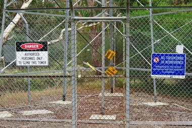
Photograph - Digital Image, Marilyn Smith, Air Navigation Facility, Montmorency, 2018. Signs at tower, 04/12/2018
Air Navigation Facility, Palara Court Montmorency, is made up of a tower and brick building surrounded by wire fences. It is sited in parkland at the end of Palara Court close to the Plenty River Trail. Warning signs are placed on the fences, including: "This facility is provided for the control and guidance of aircraft". This photograph shows signs at tower.Digital copy of colour photographair navigation facility, air control, palara court montmorency -
 Greensborough Historical Society
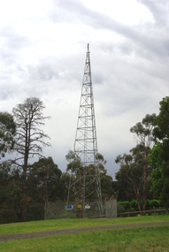
Photograph - Digital Image, Marilyn Smith, Air Navigation Facility, Montmorency, 2018. Tower, 04/12/2018
Air Navigation Facility, Palara Court Montmorency, is made up of a tower and brick building surrounded by wire fences. It is sited in parkland at the end of Palara Court close to the Plenty River Trail. Warning signs are placed on the fences, including: "This facility is provided for the control and guidance of aircraft". This photograph shows the tower on the site.Digital copy of colour photographsair navigation facility, air control, palara court montmorency -
 Greensborough Historical Society
Photograph Collection, Tom Vickers - Rotarian, 1990s
Portraits of Tom Vickers, wife Beryl and photographs of Rotary activities. Tom Vickers was the Greensborough pharmacist and a well known identity in the area. One photograph depicts Tom Vickers and Graeme Trotter with the commemorative plaque at the pioneer children's cemetery near the Plenty River Greensborough. Te plaque was donated by Greensborough Rotary.Local identity and Rotary activities.4 photographs in orange folder.Captions on back of each photograph.greensborough rotary, tom vickers, beryl vickers, graeme trotter. -
 Greensborough Historical Society
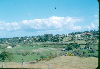
Photograph - Digital image, Frank Robinson, Looking west over Pope's paddock to Main Street, 1954_
Looking west over Pope's paddock to Main Street. The Blackjack property, house and acres of fruit orchards ran down to the Plenty River off Hume Street Greensborough and was the home of the Robinson family to late 1956. The photographs were taken as slides by Frank Robinson and digitised by his son James in 2015.Digital copy of colour photograph.popes paddock, main street greensborough, blackjack -
 Eltham District Historical Society Inc
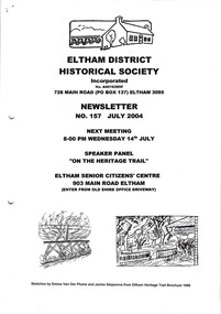
Newsletter, Newsletter, No. 157 July 2004
Contents: • Next meeting, Speaker Panel: On the Heritage Trail • Eltham Major Activity Centre • Maroondah Aqueduct Across the Plenty River • Eltham East Choir • President’s Notes • Alan Marshall’s Bungalow • Robert Bruce Ness 1917-2004 incl Ness Family History by Joy Ness • More News The Shire of Eltham Historical Society was formed in October 1967. The first newsletter of the Society was issued May 1978 and has been published continuously ever since on a bi-monthly basis. With the cessation of the Shire of Eltham in late 1994, the Society's name was revised to Eltham District Historical Society and this name first appeared with issue No. 103, July 1995. The collection of the Society's newsletters provides a valuable resource on the history of the Society's activities, office bearers and committee members, guest speakers and subjects of historical interest pertinent to the former Shire of Eltham and the Eltham District.A4 photocopied newsletter distributed to membersnewsletter, eltham district historical society, shire of eltham historical society -
 National Wool Museum
Sale notice, "Darriwill"
Sale notice lists property as belonging to the Hope family for the last 100 years, who were the original owners. The property contains a bluestone house, stables, a carpenters shop, two cottages, working ammenities, all fronting the Moorabool River and Sutherland Creek. Notice was used in the NWM Woolbrokers office display.sheep stations - history property sales wool brokering, dennys, lascelles limited strachan and co. limited, hope, mr alistair, sheep stations - history, property sales, wool brokering -
 Melbourne Legacy
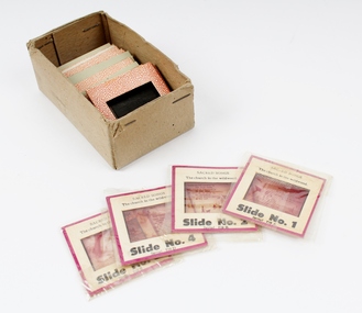
Slide - Slides, Comradeship songs
The subject of these slides is not known until they are looked at again, their titles could give clues to the contents. Some titles that can be seen are; Tavern in the Town, I love you truly, The old spinning wheel The good old summer time Swannee River Bell's of St Mary's Nursie Little brown jugA record of the types of songs sung by Legatees at Comradeship gatherings. Comradeship meetings were very important to the Legatees. Legatees supported each other by coming together for various events throughout the year. Coloured 35mm slides, coloured photo surrounded by cardboard border.Various titles of songs on individual slides.comradeship, songs -
 City of Warrnambool Rowing Club
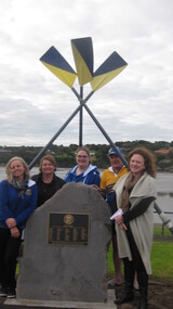
Plaque, 07 08 2016
The City of Warrnambool Rowing Club (CoWRC) received a grant from the Warrnambool City Council Community Development Fund for the project: to hold a public event to install a plaque – dedicated to members and ex members who enlisted in WW1. The original honor roll had been lost to history. The date chosen was August 7 as this was 100 years since the death of a particular member, Major Thomas (Tom) Redford. Process: the Club wrote a book about its 140 year history and learnt of the honor roll. Every effort to find it was exhausted. The Club applied for funds to produce a replacement plaque and have a public event to unveil it. Outcome: There is now a permanent plaque in the rowing ‘prescient’ on the Hopkins River. one meter high stone with brass plaque‘Lest we Forget’ Honour Roll of Warrnambool Rowing Club Members and ex-Members who enlisted for the First World War. Archibald W. Artso E. Baillie T. Battarbee M. Beeching J. Beeching W. Brown J. Brown S. Butler G. Chapman R. Chew A. Collins A. Cordner J.A. Curtis J.P. Davidson W.J.S. Dickson J.R. Dwyer T. Fary G. Fisher C. Fisher R. Flett C. Flett F. Flett V. Foote E. Gartlan L. Granter J. Harris H. Hope W. Humphreys C. Jackway W.R. King C. Lee R. Levy J. London D. MacKinlay W. MacKnight C.C. Manson A. Marfell W.L. McDougall K. McGee W. McKay M. McKay R. McKenzie W. McLennan W. McMeekin W. Mitchell S. Murphy R.S. O'Donnell J. Parsons L. Redford T. Richter F. Roper H. Robinson C.F. Robinson G. Ryan P. Sarll W. Spotswood D. Thompson A. Thompson H.G.(J) Tinker E. Titford R.A. MC Webb W. Williamson C. Every Club member of military age enlisted. A Norfolk Island Pine was planted in November 1916 to perpetuate the memory of former member, Major Thomas Redford, who died at Gallipoli. The tree is believed to be beside the Hopkins River in EJ King Park. Honour Roll rededicated by the City of Warrnambool Rowing Club and Warrnambool City Council, August 7 2016. city of warrnambool rowing club, warrnambool, warrnambool rowing club, hopkins river, hopkins river warrnambool, world war one, first world war, rowing, rowers -
 Marysville & District Historical Society
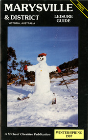
Booklet (Item) - Leisure guide, Michael Chesire & Associates Pty. Ltd, MARYSVILLE & DISTRICT LEISURE GUIDE-WINTER/SPRING 1987, 1987
A free leisure guide to Marysville and the surrounding district published for Winter and Spring, 1987. This was produced by Michael Cheshire as a free publication to promote tourism in Marysville and the surrounding district. It includes maps of the Big River Valley, Cumberland Valley, Lady Talbot Forest Drive, the Marysville area, and the township of Marysville. It was released in the winter of 1987. A free leisure guide to Marysville and the surrounding district published for Winter and Spring, 1987.marysville, victoria, australia, leisure guide, michael cheshire & associates pty ltd, marysville golf club, blackwood lodges, sir colin mackenzie fauna park, lake eildon, fraser national park, yarra valley wineries, marysville coach tours, kooringa, marylands guest house, lady talbot forest drive, wishing well, taggerty river recreation area, athols abbey, phantom falls, keppel falls, the beeches walking track, marylyn guest house, kufstein inn motel, the cumberland, marysville tourist & progress association, marysville newsagency & general store, crossways restaurant & motel, beauty spot walk, tree fern gully walk, michaeldene track, keppel track, woods lookout track, marysville hotel motel, lake mountain ski hire, marysville recreation and fun park, mytanta horseback safaris, upper big river valley, the big culvert, marysville mountain view horse hire, maryton park, amber view holiday lodges, cathedral restaurant, the top shop, tower motel, menzes garage, marysville ski hire, lake mountain ski school, faraway forest, scenic motel, buxton trout farm, marysville hardware, timbertop steakhouse, marysville trout farm, healesville sanctuary, buxton hotel motel, nanda binya lodge, buxton antique and furniture mart, the black spur inn hotel, alexandra, lake mountain, j l gould sawmills pty. ltd., geoffrey pope & associates, marysville crafts & gifts, olde yarra track shoppe, cumberland scenic reserve, tudor lodge road house, fruit salad farm, highwayman's retreat, beauty spot display gardens & nursery, ski lake mountain cross country ski hire & kitchen, buxton store, valley view marysville, acheron way, mt donna buang road, snow gum woodlands, alpine ash forests, mountain ash forests, stringybark forests, messmate forests, manna gum forests -
 Greensborough Historical Society
Map, Melbourne and Metropolitan Board of Works. Survey Division, MMBW, Yarra 2500 / 13.23. Plenty, Middle Gorge, 1978_04
Melbourne and Metropolitan Board of Works. Yarra 2500 [base map] 13-23. Plenty / Middle Gorge. Parish of Morang 3183. Municipalities of Diamond Valley 257 and Whittlesea 239. Prominent streets include: Gorge Road, Kurrak Road and Browns Lane. Features include the Plenty River and Plenty Gorge Park.MMBW Map in 1:2500 [scale] series. Cream parchment with green tape reinforcing on edges and punched holes on left edge.mmbw, melbourne and metropolitan board of works, shire of diamond valley, plenty - maps, plenty gorge park -
 Greensborough Historical Society
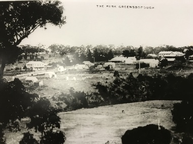
Photograph, The Park Greensborough, 1900c
View of Greensborough Park from Partington's Hill, showing sporting ground, Plenty River, Marble Hall, sparse housing on north side of Main Road, the Farmers' Arms hotel, the Rechabite Hall and Main Road bridge over the the railway line. Marble Hall is the double-storied building on the corner of Main Road.Part of a collection of 5 enlarged photographs dating from the early 1900s.Black and white enlargement of photographgreensborough park, main street greensborough, rechabite hall, farmers' arms hotel, marble hall, greensborough railway -
 Greensborough Historical Society
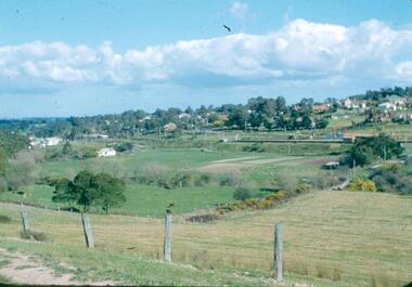
Photograph - Digital image, Frank Robinson, Looking south east from Pope's paddock to the railway line, 1954_
Looking south east from Pope's paddock to the railway line. The Blackjack property, house and acres of fruit orchards ran down to the Plenty River off Hume Street Greensborough and was the home of the Robinson family to late 1956. The photographs were taken as slides by Frank Robinson and digitised by his son James in 2015.Digital copy of colour photograph.robinson family, popes paddock -
 Greensborough Historical Society
Photograph - Digital image, Frank Robinson, Looking south west from Pope's paddock to the swing bridge, 1954_
Looking south west from Pope's paddock to the swing bridge. The Blackjack property, house and acres of fruit orchards ran down to the Plenty River off Hume Street Greensborough and was the home of the Robinson family to late 1956. The photographs were taken as slides by Frank Robinson and digitised by his son James in 2015.Digital copy of colour photograph.robinson family, popes paddock, blackjack -
 Greensborough Historical Society
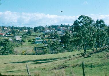
Photograph - Digital image, Frank Robinson, North end of Pope's paddock looking west to township, 1954_
North end of Pope's paddock looking west to township of Greensborough. The Blackjack property, house and acres of fruit orchards ran down to the Plenty River off Hume Street Greensborough and was the home of the Robinson family to late 1956. The photographs were taken as slides by Frank Robinson and digitised by his son James in 2015.Digital copy of colour photograph.robinson family, blackjack, popes paddock -
 Greensborough Historical Society
Photograph - Digital image, Marilyn Smith et al, Janefield Precinct: junk left by surveyors, 27/11/2014
Junk left by surveyors. The remains of this site are between Greensborough and Janefield. A RAAF Hygiene Training Camp was located on the Plenty River, just south of the Janefield community. It was in use from 1944 to 1946. The Camp was constructed from salvaged materials. Instruction included building and maintenance of grease traps, latrines, elementary plumbing and carpentry.Early remains of a WW2 training camp Digital colour photograph.janefield, raaf hygiene training camp janefield -
 Kiewa Valley Historical Society
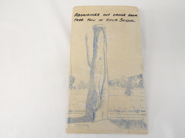
Sketch Tree Bark, Aboriginal - bark removed from tree
This sketch of a tree whose bark was cut, by aboriginal craftsmen, to produce a canoe for fishing in the rivers running through the Kiewa Valley either before or just after the 1800's. The tree trunk depicted in the sketch would have been used at the beginning of European settlement in the Kiewa Valley or just before contact was made.As this sketch was of a tree found along the Kiewa River it indicates that Aborigines lived by the river. This sketch depicts the usage of tree bark by the Aboriginal fisher person in crafting a canoe to cross rivers and to fish in the deeper sections of the river course.This freehand sketch detailing the outline of bark removed to provide a canoe is in ink portraying a tree trunk with one branch which has a plaque in front a gravel section to the right and open fields in the mid background and scattered trees on a hill slope in the far background. The sketch is on thick cardboard with a plastic protective cover over it (fastened on the flip side). It is a sketch of the tree now exhibited at the Kiewa Consolidated School.Written in black ink on the top section (heading) "ABORIGINES CUT CANOE FROM TREE. NOW AT KIEWA SCHOOL"crafted canoe, aboriginal craftsmanship, tree usage, early aboriginal craftsmen, kiewa river. kiewa consolidated school -
 Stratford and District Historical Society
Photograph, Framed
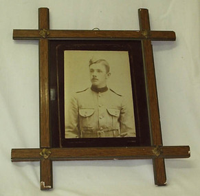
The photograph that appears in this frame is a copy. The original is catalogued at 01314. Sgt David Hamilton Pruden, 404, enlisted from Newry and was killed at Koster River in the Trasnvaal on 21 July 1900, and was buried at Rustenburg cemetery. He is commemorated in a large tablet in the Stratford Mechanics' Institute. This photograph originally hung in the Stratford Mechanics' Institute. A framed sepia copy photographic print of a head and shoulders portrait of a young man in dress uniform of the Victorian Mounted Rifles, labelled Pte D.Pruden and presumed to be David Hamilton Pruden, who died in Africa during the Boer War. The frame, of crossed wooden bars with decorative metal at each crossing, appears to be commercially produced. Backing support for the frame is a section of an 1893 calender for an unknown insurance firm, agent J.B Kelly at Stratford, which has been detached for separate cataloguing.boer war 1899-1902 -
 Yarrawonga and Mulwala Pioneer Museum
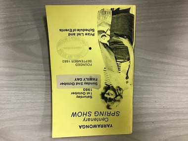
Show schedule, Yarrawonga Centenary Spring Show, Saturday October 1st, 1983, 1983
The first show was held inSept 1883 at Alexander Park on the Murray River. Two years later it was moved to the Showgrounds south of the town. Two shows have been missed, one due to WW2 and the other due to drought and a poor season. The Centenary Show was held over two days with a street parade on the Sunday.A5 size booklet Yellow card cover. Newspaper quality pages. Lists committee members,Life members, Stewards,prizes, classes and events -
 Ballarat Heritage Services
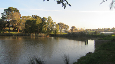
digital photographs, Lisa Gervasoni, Pre-Olympic Swimming Pool at Kilmore, c2012, c2010-2017
There are many reports of early swimming holes in 19th Century Victoria. Between the period 1895 - 1920, most rural Councils were under pressure to provide more formalised bathing arrangements. Often this occurred through the building of wooden enclosures in rivers, the damming of creeks, the construction of lakes, or the utilisation of old pits for the purpose.Colour photograph of the site of the former Kilmore Pool, now a reservoir on the Kilmore Golf Club. swimming pool, sport, swimming, pre olympic, natural, lake, kilmore, pre-olympic -
 Sunbury Family History and Heritage Society Inc.
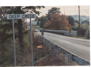
Photograph, Bulla, C 1980s
The photograph shows the approach to the Bulla Bridge at Deep Creek in the Township of Bulla. Immediately on crossing the bridge there is a sharp bend in the road and a step ascent up Bulla Hill through the cutting until level ground is reached. The photograph is looking to the NW. Deep Creek meets the Maribyrong River further downstream and closer to Keilor.The bridge and road replaced the ford crossing in 1869 that was downstream from the bridge.A coloured photograph of the approach to a bridge over the Deep Creek at Bulla along Sunbury Road. bulla bridge, deep creek, sunbury road