Showing 27536 items
matching yarra-river
-
 Tatura Irrigation & Wartime Camps Museum
Newspapers re/ local floods 1974, McPherson's Printing Group, Victoria, Tatura Guardian & Shepparton News, May 1974
Detailed history of 1974 floods in Shepparton and Mooroopna.Tatura Guardian 22 May 1974. Shepparton News 17th & 18th May 1974. Relating to record floods in the Goulburn River affecting Shepparton, Mooroopna, and Undera and to a lesser degree Tatura and Merrigum.record floods mooroopna & shepparton -
Tatura Irrigation & Wartime Camps Museum
Booklet, Shepparton, 1991
Commissioned by City of Shepparton showing history of Shepparton in pictures, from early days, culture, industries, leisureNavy blue cover. Main picture on front cover Monash Park by night. Water features lit up, small orchard scene and boating on river. Back cover - fireworks at Lake Victoria.shepparton, goulburn valley, city of shepparton, history of shepparton -
Lakes Entrance Regional Historical Society (operating as Lakes Entrance History Centre & Museum)
Book, Stone, John and Smith, Roger, East Gippsland Wilderness Walks. The Rodger-Bowen Walk, 1986
Guide to the 9 walks in the Rodger-Bowen wilderness, east of the Snowy River in far East Gippsland, Victoria. Includes a locality sketch map and sketches of leaves and fruit of eucalypts which may be encountered.natural history, vegetation, gippsland -
Stawell Historical Society Inc
Slide, Bill & Joy Attrill, Set of 12 Boxes of slides
Long time members of Stawell Historical Society 5 Boxes of Wimmera River 1961-1986 5 Boxes of Houses & Buildings 1980's 1 Box Plaques/Monuments Stawell Area 1 Box Deep Lead School 1993houses, buildings -
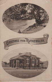 Rutherglen Historical Society
Postcard - Image, Greetings from Rutherglen, c1890
Post card featuring two black and white photographs with a banner saying "Greetings from Rutherglen" between the photos. The top one is captioned "The Murray River", the bottom one captioned "Post Office" rutherglen, murray river, rutherglen post office, buildings, rivers -
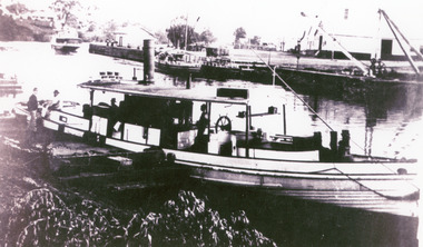 Lakes Entrance Regional Historical Society (operating as Lakes Entrance History Centre & Museum)
Photograph, 1900 c
Ref Maritime Guide on the Gippsland Lakes P18 by J.A Derbyshire BairnsdaleEnlarged black and white photograph showing small steamer Waratah on Mitchell River at Bairnsdale Wharf, S S Gippsland far left, old butter factory far right. Bairnsdale Victoria -
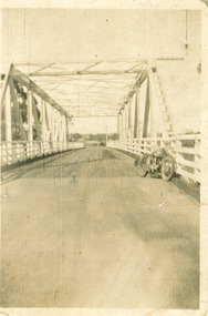 Lakes Entrance Regional Historical Society (operating as Lakes Entrance History Centre & Museum)
Photograph, 1940
After 1934 flood damage to second bridge, centre pile was replaced by a truss girder, this survived until 1971 floodBlack and white photograph showing second Orbost Bridge over the Snowy River, wooden planks, railing and overhead support. Motor bike leaning on railing at near end of bridge. Orbost, Victoria.bridges, waterways -
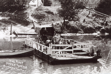 Lakes Entrance Regional Historical Society (operating as Lakes Entrance History Centre & Museum)
Photograph, Burman A W, 1905
Black and white photograph of the punt over the Tambo River showing the punt man standing beside a buggy with hood up drawn by three horses, driver seated in buggy. Upper Tambo Victoria,boats and boating, waterways -
Lakes Entrance Regional Historical Society (operating as Lakes Entrance History Centre & Museum)
Photograph, 1900 c
A popular Sunday outing venue was at Tambo UpperCopy of black and white photographic print showing large picnic party, steamer possibly Tanjil in background at a steamer landing on Tambo River between Swan Reach and Bruthen East Gippsland Victoriaagriculture, exhibition -
Lakes Entrance Regional Historical Society (operating as Lakes Entrance History Centre & Museum)
Photograph, Gippsland Ports, 2006 c
Colour aerial photograph showing the entrance to Gippsland Lakes from Bass Strait westward to Reeves Channel Shaving Point at Metung through Lake King to Tambo River Gippsland Lakes Victoriaaerial photograph, waterways, township, topography -
Beechworth Honey Archive
Map- Chiltern/Barnawartha
(4x) Map centred on Chiltern and Barnawartha. Shows Murray River, Hume Highway, Chiltern- Barnawartha Rd and Chiltern- Rutherglen Rd. Scale 1:50,000. Paper is white on back, yellow on front.Map labelled 'Albury series R652' Some markings in red and blue on some maps- blue writes '74-75'map, chiltern, barnawartha, paper, beechworth honey -
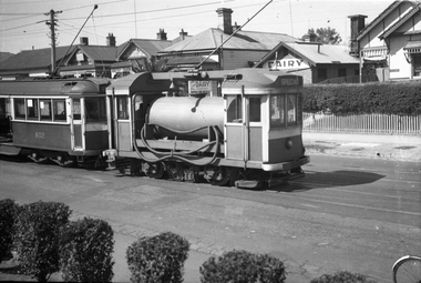 Melbourne Tram Museum
Negative, Wal Jack, 15/03/1945 12:00:00 AM
Black and white negative, by Wal Jack, of Scrubber 8 and W5 802 in Maribyrnong Road. Wal's album notes that the photo is at the River terminus and dated 15-3-1945. In the background is the Lily Dairy.trams, tramways, maribyrnong rd, scrubber tram, work trams, w5 class, tram 8, tram 805 -
 Bendigo Historical Society Inc.
Postcard - Alice McGregor Postcard Collection, 1900 - 1920
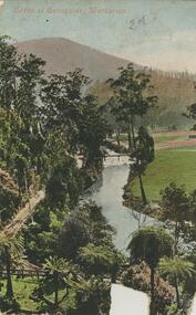
Alice McGREGOR Born: 1908; unknown parents. Possibly adopted by the Salter family? Electoral Roll 1936: Highland Terrace Kangaroo Flat. Alice Mary Salter and William Robert Salter living together; presumed to be sister and brother. William Robert Salter was killed in a MVA in Bendigo in 1937 aged 26. In Victoria in 1938, Alice Mary Salter married James Thomas McGregor (born Victoria 1917, died Victoria 1983, buried Fawkner Cemetery) Lived: 1968; 22 Wade Street Golden Square Alice McGregor Died: 1999 aged 91 at Anne Caudle Centre, Bendigo Buried: Kangaroo Flat Cemetery See additional research. Postcard Album of Alice McGregor contained 86 post cards.Postcard Album of Alice McGregor containing 86 post cards. See 1400 Colour image of a Scene at Sunnyside, Warburton, Victoria Path running beside a river with trees and a footbridge. Mountain in background Addressee - unknown Sender - H S date 2/11/05 postcard, collector, alice mcgregor -
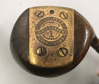 Heidelberg Golf Club
Leisure object - Golf club, Harry Alexander No.1 wood, 1927-1932
Previously greenkeeper at Yarra Yarra Golf Club, Harry Alexander joined Heidelberg Golf Club in June 1927 to 'set out the new links'. He was the golf professional at HGC from 1927-1932. This club is inscribed with his name and that of the HGCMetal shaft and wooden head, leather grip.On brass plate on base of head: "H. Alexander Heidelberg Golf Club 1"heidelberg golf club, golf clubs, woods, harry alexander, golf professionals -
 Eltham District Historical Society Inc
Photograph, Fay Bridge, Eastern boundary of former Warrandyte Aboriginal Reserve, North Warrandyte, 7 November 2016
Two bronze commemorative plaques on rocks, unveiled by Wurundjeri Tribe Council Elders, mark two eastern boundaries of the former Warrandyte Aboriginal Reserve on the north and south sides of the Yarra. This project was initiated by Nillumbik Reconciliation Group in close association with Reconciliation Manningham and the Wurundjeri Tribe Council, as a means of commemorating the last great corroboree of the Kulin Nation which was held at Pound Bend in March 1852. This plaque is on the Nillumbuk side of the Yarra, accessed via The Boulevard, North Warrandyte. The plaque is set on a rock approximately 50 metres before the turning circle at the end of The Boulevard. Plaque : Warrandyte Aboriginal Reserve This commemorative rock marks an eastern boundary of the former Warrandyte Aboriginal Reserve established in 1852. Centred on Pound Bend, it covered 1,908 acres on both sides of the Yarra River (Birrarung). That same year saw the last great gathering of the Kulin nation here in Wurundjeri country which was celebrated over two weeks with traditional performance and games. For a few years longer the reserve intermittently served as a ration station.With gold having been discovered at Warrandyte, the Wurundjeri were moved on again but ultimately secured a permanent home at Coranderrk, Healesville. A second commemorative plaque and rock is located on the opposite bank of the Yarra and its confluence with Stony Creek. Melway ref : 23 C 9 Unveiled by Wurundjeri Elder, Uncle Bill Nicholson on 23rd March 2013 Funded by the Robert Bridgford Indigenous Trust (Nillumbik Community Fund) with assistance from Manningham City Council Small Grants Program Ref: Monument Autralia https://monumentaustralia.org.au/themes/culture/indigenous/display/99680-warrandyte-aboriginal-reserve-fay bridge collection, 2016-11-07, aboriginal reserve, north warrandyte, plaques, warrandyte aboriginal reserve -
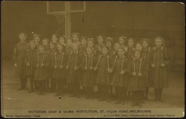 Deaf Children Australia
Postcard, N.J.Caire, Girls' Gymnastic Class, 1909
The Board of the VDDI wanted to provide for the spiritual, moral and physical well-being of the pupils. Gymnastic classes were run separately for girls and boys.B&W photograph by N.J.Caire, on a postcard, of the Girls' Gymnastic Class at the VDDI (Victorian Deaf and Dumb Institution) On Front of postcard: "VICTORIAN DEAF & DUMB INSTITUTION, ST. KILDA RD., MELBOURNE./Girls' Gymnastic Class/N.J.CAIRE, Photo, 4 Darling Street, South Yarra, Victoria." deaf children australia -
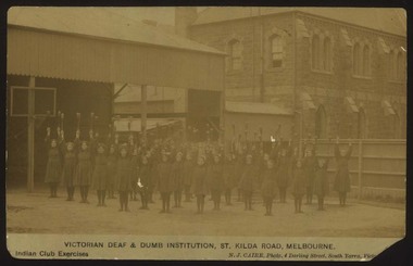 Deaf Children Australia
Postcard, N.J.Caire, Indian Club Exercises, 1909?
B&W photograph by N.J.Caire, on a postcard, of the girls' Indian Club exercises, at the VDDI On Front of postcard: "VICTORIAN DEAF & DUMB INSTITUTION, ST. KILDA RD., MELBOURNE./Indian Club Exercises/N.J.CAIRE, Photo, 4 Darling Street, South Yarra, Victoria." deaf children australia, victorian school for deaf children, educaion, pupils, gymnastic class, indian club exercises -
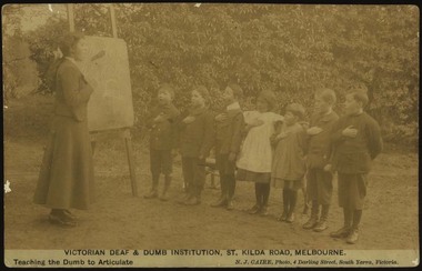 Deaf Children Australia
Postcard, N.J.Caire, Teaching the Dumb to Articulate, 1909?
These are a pictorial documentation of the early years of the Victorian Deaf and Dumb Institution. A record of the people, children, buildings and activities of the Victorian Deaf and Dumb Institution up to 1920. B&W photograph by N.J.Caire, on a postcard, of the pupils in a class learning to articulate at the VDDI On Front of postcard: "VICTORIAN DEAF & DUMB INSTITUTION, ST. KILDA RD., MELBOURNE./Teaching the Dumb to Articulate/N.J.CAIRE, Photo, 4 Darling Street, South Yarra, Victoria." deaf children australia, dca, victorian deaf & dumb institution, vddi, deaf education, pupils, n. j. caire -
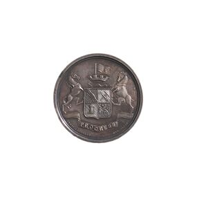 City of Greater Bendigo - Civic Collection
Medal - Sandhurst Industrial Exhibition Medal, Ernest A. Altmann, 1879
The Sandhurst Industrial Exhibition was held in Sandhurst at the Market Building and Corn Exchange and was opened by the Marquis of Normandy on the 17th March 1879. Modelled on a similar event held in Ballarat the previous year which was largely aimed at displaying the work of juvenile artisans, the Sandhurst Exhibition was more general in its purpose and provided more space for the general exhibition of products, natural and manufactured from the broader surrounding district. The opening event included a procession of all the friendly societies, fire brigades and other local institutions. Obverse Description; Bendigo Coat of Arms Reverse Description; (Text only) Edge Description; PlainObverse Description: Progress Ernst A Altmann Reverse Description: Sandhurst Industrial Exhibition / 1879 / Awarded to / George R Bennett / South Yarra / Inlaid Marble / Chess Tablecity of greater bendigo medals, sandhurst industrial exhibition 1879 -
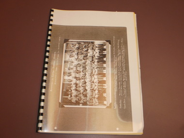 Wangaratta High School
WHS Magazine -Korrumbeia, 1952
This is the transition year as the Wangaratta High school magazine is renamed to Korrumbeia. Korrumbeia is Victorian aboriginal term meaning restful river/creek (Kurrabi; creek, Umina; rest, Beeia; river) This is a reference to the Ovens and King rivers merging in Wangaratta, and the fact that WHS houses are named after local waterways.Black and white photocopy of the 1952 edition of Korrumbeia featuring a large image of the interschool sports athletics team -
 Marysville & District Historical Society
Booklet - Information booklet, Ann Thomas, Wilks Creek Bridge, 1993
A history of the Wilks Creek Bridge and its connection to the Yarra Track.Paperback. Front cover has an old photograph of the Wilks Creek Bridge.non-fictionA history of the Wilks Creek Bridge and its connection to the Yarra Track.wilks creek bridge, yarra track, narbethong, marysville, victoria, clement wilks, wood's point goldfields, jordan goldfields, john monash, monash and anderson, 2009 black saturday bushfires -
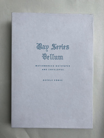 Robin Boyd Foundation
Functional object - Stationary
Personalised stationery for 290 Walsh St South Yarra 3141Bay Series Vellum Watermarked Notepaper and Envelopes. deckle edgeswalsh st miscellaneous, robin boyd -
 Robin Boyd Foundation
Functional object - Stationary
Personalised stationery for 290 Walsh St South Yarra 3141Bay Series Vellum Watermarked Notepaper and Envelopes. deckle edgeswalsh st miscellaneous, robin boyd -
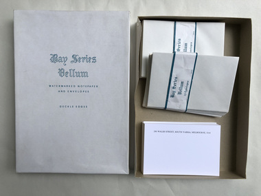 Robin Boyd Foundation
Functional object - Stationary
Personalised stationery for 290 Walsh St South Yarra 3141Bay Series Vellum Watermarked. Cards and mostly envelopes and Envelopes. deckle edgeswalsh st miscellaneous, robin boyd -
Kew Historical Society Inc
Booklet - Old Kew Golf Links Estate, 1926
Subdivision plans and real estate flyers/brochures reveal a number of aspects of urban development and history. The Kew Historical Society's collection of these plans, as well as advertisements extracted from magazines, cover key aspects of community development and architectural history of Kew and Kew Eat as well as surrounding suburbs. While most of the plans in the collection were gifted to the Society by the former City of Kew, a number of other plans and advertisements have been donated by individuals, of which this is an example.8-page brochure advertising 80 residential home sites for sale in a subdivision called the 'Old Kew Golf Links Estate'. These sites had historic importance in Kew's history as they had previously belonged to Kodak Pty Ltd who were refused permission by Kew Council to use the land for industrial development. The estate, advertised was advertised as being within five miles of Melbourne. The brochure is notable as it includes photographs of Kew East Primary School, the former Kew Golf Club clubhouse, and 'The Moorings' Boathouse (aka Chipperfield's Boat House). The aerial photograph, overlaid with names of notable sites, on the final page is of interest as it shows the area before the intrusion of the Eastern Freeway, which resulted in changing the course of a section of the Yarra River. old kew golf links estate, subdivision -- kew (vic.), subdivisions -- kew east (vic), chipperfield's boathouse, kew east primary school, kew golf club -
 Kew Historical Society Inc
Photograph - Grampians, 1924
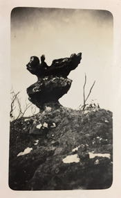
Henry Beater Christian (1886-1962) , was a descendant of one of the earliest settler families in Kew. Employed at the Kew Asylum as a 'public servant', he was a skilled amateur photographer, photographing numerous scenes in Kew and on his travels around Victoria. The majority of his photographs date from 1916 to 1929. His finest photographs are housed in two photograph albums. Digital copy of a photograph from page 12 of the 47-page photograph album containing 261 gelatinous silver images, loaned by Diane Washfold with permission given to digitise and hold a copy in our collection. The first and last pages in the album document the Yarra River at Studley Park and at Kew. The remainder of the album includes photographs of walking and car tours in rural Victoria including 'wilderness' areas in the Grampians, Gippsland and the High Country. Six album pages document a camping trip by Henry Christian to the Grampians in September 1924. The photos include pictures of lookouts, and natural features including rock faces and waterfalls, as well as his camp site. This photo is of a self-standing rock on what is probably the Mt Victory trail. "Mt Victory / Grampians / 9.24"henry beater christian (1886-1962), landscape photography, christian-washfold collection, photograph albums, grampians, mt victory, gariwerd -
 Kew Historical Society Inc
Photograph - Grampians, 1924
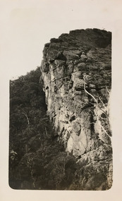
Henry Beater Christian (1886-1962) , was a descendant of one of the earliest settler families in Kew. Employed at the Kew Asylum as a 'public servant', he was a skilled amateur photographer, photographing numerous scenes in Kew and on his travels around Victoria. The majority of his photographs date from 1916 to 1929. His finest photographs are housed in two photograph albums. Digital copy of a photograph from page 13 of the 47-page photograph album containing 261 gelatinous silver images, loaned by Diane Washfold with permission given to digitise and hold a copy in our collection. The first and last pages in the album document the Yarra River at Studley Park and at Kew. The remainder of the album includes photographs of walking and car tours in rural Victoria including 'wilderness' areas in the Grampians, Gippsland and the High Country. Six album pages document a camping trip by Henry Christian to the Grampians in September 1924. The photos include pictures of lookouts, and natural features including rock faces and waterfalls, as well as his camp site. This photo is of one of a well-known cliff face on one of the walking trails. Unitled [Grampians]henry beater christian (1886-1962), landscape photography, christian-washfold collection, photograph albums, grampians, mt victory, gariwerd -
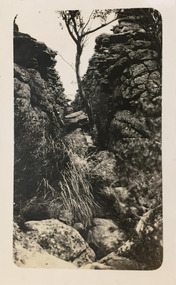 Kew Historical Society Inc
Photograph - Grampians, 1924
Henry Beater Christian (1886-1962) , was a descendant of one of the earliest settler families in Kew. Employed at the Kew Asylum as a 'public servant', he was a skilled amateur photographer, photographing numerous scenes in Kew and on his travels around Victoria. The majority of his photographs date from 1916 to 1929. His finest photographs are housed in two photograph albums. Digital copy of a photograph from page 13 of the 47-page photograph album containing 261 gelatinous silver images, loaned by Diane Washfold with permission given to digitise and hold a copy in our collection. The first and last pages in the album document the Yarra River at Studley Park and at Kew. The remainder of the album includes photographs of walking and car tours in rural Victoria including 'wilderness' areas in the Grampians, Gippsland and the High Country. Six album pages document a camping trip by Henry Christian to the Grampians in September 1924. The photos include pictures of lookouts, and natural features including rock faces and waterfalls, as well as his camp site. This photo is of one of opposing rock faces on one of the walking trails. Unitled [Grampians]henry beater christian (1886-1962), landscape photography, christian-washfold collection, photograph albums, grampians, gariwerd -
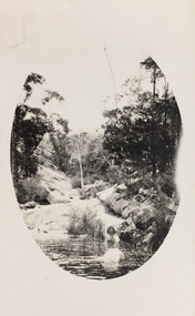 Kew Historical Society Inc
Photograph - Grampians, 1924
Henry Beater Christian (1886-1962) , was a descendant of one of the earliest settler families in Kew. Employed at the Kew Asylum as a 'public servant', he was a skilled amateur photographer, photographing numerous scenes in Kew and on his travels around Victoria. The majority of his photographs date from 1916 to 1929. His finest photographs are housed in two photograph albums. Digital copy of a photograph from page 14 of the 47-page photograph album containing 261 gelatinous silver images, loaned by Diane Washfold with permission given to digitise and hold a copy in our collection. The first and last pages in the album document the Yarra River at Studley Park and at Kew. The remainder of the album includes photographs of walking and car tours in rural Victoria including 'wilderness' areas in the Grampians, Gippsland and the High Country. Six album pages document a camping trip by Henry Christian to the Grampians in September 1924. The photos include pictures of lookouts, and natural features including rock faces and waterfalls, as well as his camp site. This photo is of a rock pool, developed within an oval framing device."Grampians"henry beater christian (1886-1962), landscape photography, christian-washfold collection, photograph albums, grampians, gariwerd -
 Kew Historical Society Inc
Photograph - Grampians, 1924
Henry Beater Christian (1886-1962) , was a descendant of one of the earliest settler families in Kew. Employed at the Kew Asylum as a 'public servant', he was a skilled amateur photographer, photographing numerous scenes in Kew and on his travels around Victoria. The majority of his photographs date from 1916 to 1929. His finest photographs are housed in two photograph albums. Digital copy of a photograph from page 15 of the 47-page photograph album containing 261 gelatinous silver images, loaned by Diane Washfold with permission given to digitise and hold a copy in our collection. The first and last pages in the album document the Yarra River at Studley Park and at Kew. The remainder of the album includes photographs of walking and car tours in rural Victoria including 'wilderness' areas in the Grampians, Gippsland and the High Country. Six album pages document a camping trip by Henry Christian to the Grampians in September 1924. The photos include pictures of lookouts, and natural features including rock faces and waterfalls, as well as his camp site. This is a photo of local flora on a bushland track in the Grampians, developed within an oval frame."Grampians"henry beater christian (1886-1962), landscape photography, christian-washfold collection, photograph albums, grampians, gariwerd