Showing 24370 items
matching matthew-creek
-
 Greensborough Historical Society
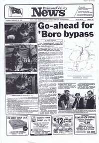
Newspaper Clipping, Helen Gillman, Greensborough Bypass Go-ahead by Helen Gillman, 28/02/1984
Construction of the Greensborough Bypass from Watsonia Road to the Civic Drive intersection with Diamond Creek Road was approved by the State government.Photocopy of article on page 1 of Diamond Valley News, 28 February1984.greensborough bypass -
 Greensborough Historical Society
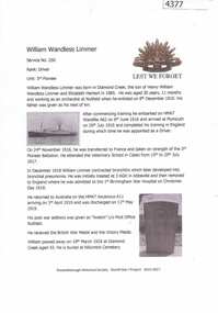
Article, Greensborough Historical Society et al, William Wandless Limmer, 1914-1918
A short article about William Wandless Limmer and his service in World War 1. William was born in Diamond Creek.One page, text and colour images.world war 1 project, william wandless limmer -
 Halls Gap & Grampians Historical Society
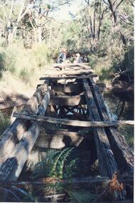
Photograph - Coloured
An old bridge on the Heatherlie Quarry rail line at Back Creek, this line was used to transport sandstone from the quarry to Stawell.Photo shows an old bridge with 3 adults at the end, one male standing and 2 adults sitting. The bridge consists of large wooden beams,cross beams and supports .water can be seen at the bottom of the depression. Bush surrounds the bridge.structures, bridges -
 Stawell Historical Society Inc
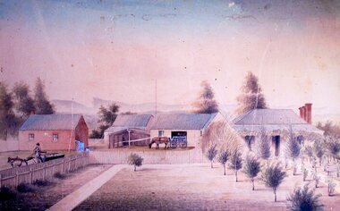
Painting, Mr J. McDougall’s Stawell Aerated Water Cordial Factory 1869 --- Photo of a Painting
Photo of painting of J. McDougall’s Aerated Water Cordial Factory 1869. Stawell opposite old Pleasant Creek Hospital.stawell industry -
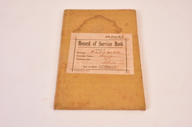 Chiltern Athenaeum Trust
Record of Service Book WW1 : Thomas Kneebone/Kneeborn, circa 1914-1918
WW1 Personnel Record Thomas Kneebone number 658. Thomas Kneebone Scholar, Black Dog Creek via Chiltern. WW1 Circa 1914-1918 Thomas Kneebone Scholar Blackdog Creek, Chiltern. Buff light tan coloured Record of Service book WW1 Thomas Kneebone Service number 658 Hard front and back cover, booklet consists o 52 pages light ivory coloured paper. A.M. Form M. 7 Record of Service Book issued to Kneeborn (Kneebone) Thomas Training Area 56C Albury. ww1 the great war 1914-1918, thomas kneebone, black dog creek, via chiltern, thomas kneebone scholar/teacher -
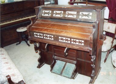 Stawell Historical Society Inc
Photograph, Estey Organ -- Coloured
Estey Organ at Pleasant Creek Court House. Original organ from the Methodist Church in good working order. c1863Coloured Photo of Estey Organ with Dorothy King, Daryl Meek and Julie Meek standing around the organ taken in 2003.2034/04/14 marked on front of photo.stawell -
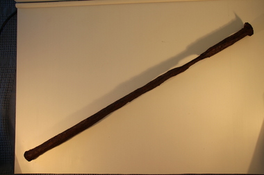 Torquay and District Historical Society
Iron Pin, Scammell Collection, Pre 1890
This item was found in 1980 at Freshwater Creek, Torquay and is believed to be from the Scammell wrecked off Point Danger, Torquay in 1891.The wreck of the Scammell was a significant event in Torquays history.Corroded steel object, pin shaped -
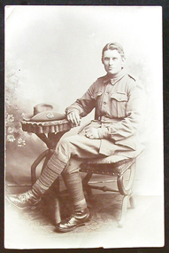 Ballarat Heritage Services
Photograph, Tony Pavich
Tony Pavich was a cousin of John Joseph Gervasoni of Yandoit Creek. Tony Pavich was killed during World War One.Photographic postcard of Australian soldier Tony Pavich.jack j. gervasoni, world war one, australian soldiers, tony pavich, antonio pavich -
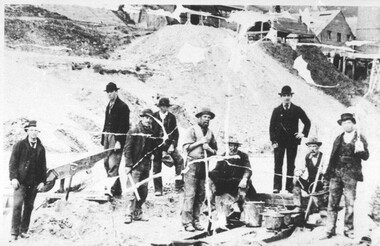 City of Ballarat Libraries
Photograph - Card Box Photographs, Mining for Pyrite, Black Hill circa 1908
Group of 9 miners catching pyrite in creek run off from the Battery located at the south end of Black Hill.mining, battery, miners, pyrite, black hill -
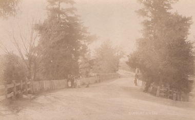 Sunbury Family History and Heritage Society Inc.
Photograph, C
The people were photographed standing on the Macedon Street bridge which spans the Jacksons Creek at the east end of the town of Sunbury.A sepia photograph in post card format of five people with a dog standing in front of a picket fence on a road bridge.SUNBURY BRIDGEmacedon street bridge, jacksons creek, sunbury -
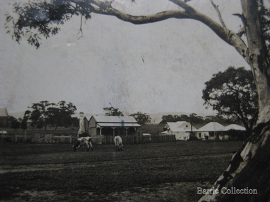 Melton City Libraries
Photograph, Original Melton settlement, c.1910
The original Melton settlement on the flat where the golf course is now located. The tree still stands over Toolern Creek.Early photograph of the original settlement in Meltonmisc. -
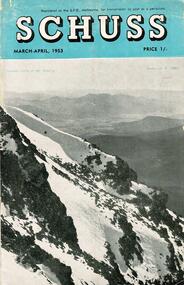 Falls Creek Historical Society
Journal - Schuss Vol. 19. No. 2 March - April 1953
Schuss was advertised as Victoria’s Official Ski Journal It was issued monthly from 1935 to 1961 except during the war when summer issues covered two months. This continued after the war, but it averaged 10 issues annually over its 25 year life. Schuss was published by the Ski Club of Victoria which had a membership of 38 Ski Clubs and demanded to be recognised as the prime authority on skiing in the state. The other 30 ski clubs with 85% of the members disagreed and the politics of skiing became heated. These clubs formed the Federation of Victorian Ski Clubs with their own journal, Ski Horizon. With the establishment of the Victorian Ski Association, Ski-Horizon published its last issue in Nov - Dec. 1955 and the role of the official journal was fully taken over by “Schuss”. This item is significant because it contains stories, images and information documenting the development of the ski industry in Victoria.The journal features stories and events chronicling developments in Victoria and internationally. Items related to the Falls Creek Area in this issue include:- Cover - Features a photo by H.Gibbs titled "Western Cliffs of Mt. Bogong" Page 65 - BOB HYMANS reported news of Falls Creek. At his own Ski School, notable improvements to accommodation have been made and additions to the building itself, which will make it very much more comfortable and serviceable to visitors. Water supply and heating are amongst the items in hand. Bob has acquired a Land Rover which will be a power of assistance to him in maintaining fresh supplies and in servicing his project generally. Kiewa Valley Ski Club members are making splendid progress with the erection of their Lodge. This is the latest building addition in that area and raises the number of clubs resident there to nine. Nissen Ski Tow members intend to operate their tow on the upper slopes of Falls Creek every day during the coming season that conditions permit. They are to be warmly commended on their enterprise. Page 65 - Advertisement for Bob Hymans' Ski School and Lodgeschuss journal, bob hymans, kiewa valley ski club, nissen tow -
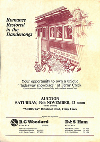 Melbourne Tram Museum
Document - Personal Papers, The Age, Keith Kings, Progress Press, Higgins Teale & Co, Herald Sun, house built using former PMTT tramcars, 1976 to 1983
Collection of Personal Papers regarding a house built using former PMTT tramcars. Comprises: 1 - Auction notice - folded A3 light card, "Moonta 18 School Road Ferny Creek" - giving details of the property, agents, floor plan and auction date of 19/11/1983. Agents R. Woodard and D&S Ham 2 - Newspaper clipping from the Progress Press with a sketch and article - "Home built from trams" 3 -"Fares please for tram treat" - Herald Sun, 24/9/1983. 4 -Auction notice - 21/11/1983 - property passed in. 5 - hand written note, with plan of the trams and location map - not dated 6 - set of six hand written notes recording conversations with various people regarding a house in Ferny Creek with trams, including the Public Trustee 1976 and 1977. 7 - Auction notice for "Charrawalla" - School Road, Ferny Creek dated 7/5/1977 from The Age. Not all items numbered, See also Reg Item 1356, 1833 and 1518 for related items.trams, tramways, mmtb, pmtt, ferny creek, tramcars, melbourne, houses, sale of land -
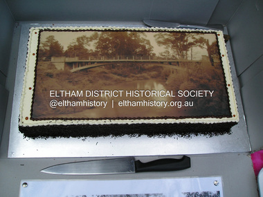
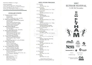 Eltham District Historical Society Inc
document - Folder, 1997 Eltham Festival, 1997
Folder Contents: 1. Program (A4 Trifold double sided) - 1997 Eltham Festival, 7, 8 & 9th November 2. Newsclipping: Festival reverts to its original name, Diamond Valley News, 21 May 1997 3. Eltham Festival returns, The Advertiser, Tuesday, May 20. 1997, p3 4. Festival funding down by $30,000, unidentified paper, 1997 (Also includes story "Play but no school" re fundraiser for Challenger St Pre-School at Diamond Creek held in the Diamond Creek Community Centre.. On reverse - "Bridges to be upgraded" by Laeta Antonysen regarding replacement of dilapidated bridges in Gipson Street, Diamond Creek)Miscellanous documents and newspaper clippings1997, eltham festival, program, challenger st pre-school, diamond creek community centre, george sartels, play school (tv show), bridge construction, gipston street, diamond creek -
 Kew Historical Society Inc
Photograph - Kew Main Drain, 1984
'Kew, Kew East, Balwyn & Balwyn North are located approximately 7km north east of Melbourne. Four main stormwater drains service the area flowing from south to north. Three of the drains: Deepdene Drain; Balwyn Drain & Glass Creek converge in Kew East just west of Burke Road at Kew High School before discharging into the Yarra River. The fourth drain, Kew Main Drain connects directly with the Yarra River to the West of Glass Creek.' The Kew Main Drain is a barrel drain that was created in the 1930s, and follows the route of the former Connor's Creek from the vicinity of Genazzano FCJ College to the Yarra River in East KewImportant and verifiable evidence of the construction methods used by the Melbourne & Metropolitan Board of Works in building the Kew Main Drain, before its reconstruction in c.1985.Original print colour positive photograph of the Kew Main Drain, provided on 14/12.84 to the Chief Engineer of the City of Kew, Ian Poulter, by the Supervising Engineer (Works), Southern and Eastern Drainage, Melbourne & Metropolitan Board of Works. The record includes an image of the reverse as well as the donation document from the MMBW."A84/1855-9 / 750mm council drain looking D/S [down stream] and across Parkhill Road. To be replaced with 1200 mm R.C.P. [reinforced concrete pipe] as part of MMBW Kew Main Drain reconstruction works"kew main drain, stormwater drains -- kew (vic.), connor's creek -- kew (vic.) -
 Kew Historical Society Inc
Photograph - Kew Main Drain, 1984
'Kew, Kew East, Balwyn & Balwyn North are located approximately 7km north east of Melbourne. Four main stormwater drains service the area flowing from south to north. Three of the drains: Deepdene Drain; Balwyn Drain & Glass Creek converge in Kew East just west of Burke Road at Kew High School before discharging into the Yarra River. The fourth drain, Kew Main Drain connects directly with the Yarra River to the West of Glass Creek.' The Kew Main Drain is a barrel drain that was created in the 1930s, and follows the route of the former Connor's Creek from the vicinity of Genazzano FCJ College to the Yarra River in East KewImportant and verifiable evidence of the construction methods used by the Melbourne & Metropolitan Board of Works in building the Kew Main Drain, before its reconstruction in c.1985.Original print colour positive photograph of the Kew Main Drain, provided on 14/12.84 to the Chief Engineer of the City of Kew, Ian Poulter, by the Supervising Engineer (Works), Southern and Eastern Drainage, Melbourne & Metropolitan Board of Works. The record includes an image of the reverse as well as the donation document from the MMBW."A84/1855-10 / 750mm council drain looking U/S [up stream] from Parkhill Road, Kew."kew main drain, stormwater drains -- kew (vic.), connor's creek -- kew (vic.) -
 Eltham District Historical Society Inc
Photograph, Fay Bridge, Centenary celebration, Monash Bridge, Hurstbridge, 7 November 2017
The area of Hurstbridge was originally known as Hurst’s-bridge after the timber bridge built over the Diamond Creek near Hurst’s station in late 1881/early 1882. It was replaced by a new concrete bridge designed by Sir John Monash over the Diamond Creek near Hurst's home of 'Mia Mia' at Hurstbridge. The official opening of the new Monash bridge at Hurstbridge was held 3 November 1917.fay bridge collection, 2017-11-07, hurstbridge, hurstbridge heritage trail, monash bridge, ruins -
 Marysville & District Historical Society
Book, The Wild Heart of the Yarra Valley, Unknown
A pictorial book of the flora, fauna, rivers, waterfalls and rainforest in the Upper Yarra ValleyPaperback. Front cover has a main photograph of a creek running through a forest. There is also four smaller photographs. They are of a Red Coral Fungi, a Superb Lyrebird, a night time view looking upwards in a grove of trees and a view of a Soft tree fern. The back cover has a photograph of a Superb Lyrebird.yarra valley, upper yarra valley, flora, fauna, photography, rivers, waterfalls, rainforest, nature, donovan wilson -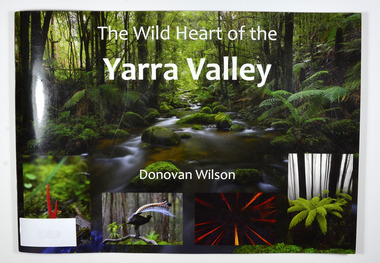
 Glenelg Shire Council Cultural Collection
Photograph - Photograph - Bridge, n.d
Sourced from Casterton Town Hall (former Shire of Glenelg)Coloured photograph. Same as 7302 7302 - Coloured photograph. Unmade road between paddocks. Photo taken close to bridge with wooden railings. Erosion of creek sides can be seen. Sign at bridge ' Bridge Load Limit 5 t gross'? Same bridge as 7301, taken at different time. -
 Federation University Historical Collection
Document, Ken Clements, Peterborough Puzzles, 2009, 2009
Massacre Bay is located on Victoria's Great Ocean Road, and is in the centre of the Bay of Martyrs. The bay consists of 20 m high, red limestone bluffs. This paper by Ken Clements considers the origin of the term martyr in connection to this location, and where the Aboriginal massacre may have taken place. Thirteen page document by Ken Clements relating to Peterborough, Victoria. Contents include coastal features, local Aborigines, Bay of Martyrs, Massacre Bay, Massacre Hill, Buckley Creek Run, Pioneer Pastoralists, British Traversers, settlers, Peterborough, Maps, tourism, history method. Photographs by Laurie Moore.aborigines, bay of martyrs, massacre bay, massacre hill, buckley creek run, pioneer pastoralists, british traversers, settlers, peterborough, maps, tourism, history method, childers cove, barque children, murnane bay, sandy bay, dog trap bay, buckley creek, viviennes lookeout, stanhope bay, buttres bay, burnies beach, armstrong creek, flaxman hill, antares rock, lovers nook, crofts bay, clements, worm bay, halladale point, the well, wold dog cove, james irvine monument, curdies inlet, squirrel creek, wallaby creek, boggy creek, whiskey creek, pioneer beach, schomberg rock, young australia, spit, crown of thorns, newfield bay, the grotto, london bridge, point hesse, high cliffs, the arch, cape martyr, little massacre bay, aboriginal massacre, ken clements -
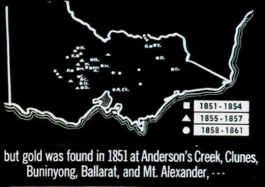 Bendigo Historical Society Inc.
Slide - DIGGERS & MINING. THE GOLD ERA, c1851
Diggers & mining. But gold was found in 1851 at Anderson's Creek, Clunes, Buninyong, Ballarat, and Mt. Alexander, - - - Slide shows map of Victoria with legend to show when gold was found in different areas. The gold era. Markings 4 994.031 GOL:5. Used as a teaching aid. Used as a teaching aid.hanimounteducation, tertiary, goldfields -
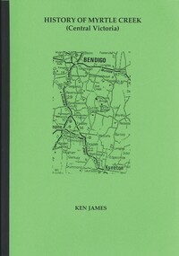 Bendigo Historical Society Inc.
Book - HISTORY OF MYRTLE CREEK, CENTRAL VICTORIA, 2005
HISTORY OF MYRTLE CREEK, CENTRAL VICTORIA - 192 pages with photos, illustrations and maps. Letter inside from Ken James, 18 Lofty Avenue, Camberwell, 3124. 17/10/05. Inscribed on front fly page ' Donated to the Bendigo Historical Society Inc. by Ken James Oct. 2005.'Ken Jameshistory, myrtle creek, myrtle creek, cockatoo creek, state schools, ken james, gold mining, quartz mining -
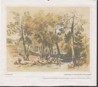 Bendigo Historical Society Inc.
Painting - CAROL HOLSWORTH COLLECTION: 1970 NATIONAL BANK PAINTING 'FITZROY BAR AT THE JUNCTION OF THE CREEKS'
1970 National Bank painting reproduction Fitzroy Bar, at the junction of the creeks by G.F. Angas 1851 Below the picture title the words - Reproduced by the National Bank in 1970 from the lithograph by courtesy of Dr. E. Graeme Robertson , Melbourne .At the foot of the painting are the words Gold Washing and Fitzroy Ophir diggingspainting, watercolour, g.f. angas 1851/ -
 Bendigo Historical Society Inc.
Document - ANCIENT ORDER OF FORESTERS NO. 3770 COLLECTION: CORRESPONDENCE
A letter of apology from John Mueller to Court King of the Forest apologising for his non attendance to his duties as Junior Woodward as he had urgent business which compelled him to go to Myers Creek. Three edges of letter have been trimmed wirh scallop shaped scissors.societies, aof, correspondence, ancient order of foresters no. 3770 collection - correspondence, court king of the forest, john mueller -
Bendigo Historical Society Inc.
Map - TANDARRA : COUNTY OF BENDIGO, 14-3-24
Map. Tandarra, County of Bendigo, Talambe, Yallook, Neilborough, Whirrakee, Kamarooka. Photo-Lithographed at the Department of Lands and Survey, Melbourne by W.J. Butson,14-3-24. Price 1/-.Myers Creek, Tandarra Estate. By authority Mullett, Government Printer, Melbourne. (number 24 in map cupboard 1)Albert J. Mullett, Government Printer, Melbourne.map, bendigo, tandarra -
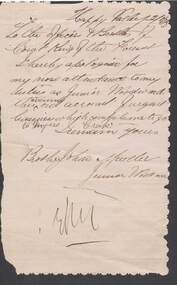
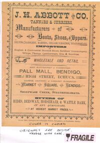 Bendigo Historical Society Inc.
Document - J.H.ABBOTT & CO
Document, Multi Pages of Advertising J.H.Abbott & Co.,Tanners & Curriers, Manufacturers of Boots, Shoes, Uppers, Belting.Saddlery, Harness, Collars, Leggings, Neatsfoot Oil. Importers of English & Continental wares. Wholesale and Retail, Pall Mall, Bendigo; High Street Echuca: Market Square, Bendigo; Sheepwash Creek, Strathfieldsaye.Bolton Bros.,Bendigo.document, names of bendigo pioneers, j.h.abbott -
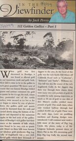 Bendigo Historical Society Inc.
Newspaper - JACK PERRY COLLECTION: NEWSPAPER GOLDEN GULLIES PART 1
Newspaper article Bendigo Weekly re Golden Gullies in Bendigo. Information regarding Peg Leg Creek, Lougsons hydraulic sluice Myers Flat, Peg Leg Gully. Photo of Mr. Lougsons hydraulic sluice of Myers Flat in the 1930's.. Recovering gold from Peg Leg Gully.Bendigo Advertiser 3.9.99person, individual, jack perry, peg leg gully, catherine, saxby, eaglehawk gully. -
Bendigo Historical Society Inc.
Map - AXEDALE, COUNTIES OF BENDIGO & RODNEY, 1961
Map, Axedale, Counties of Bendigo & Rodney.Axe Creek, Campaspe River, Longlea Railway Station, Axedale Railway Station, Wallan & Bendigo Railway.Township of Axedale. By authority A.C.Brooks, Govt. Printer, Melbourne.Drawn and reproduced at the Dept. of Lands and Survey, Melbournd. Price 1/-. 1961. (number 61 in map cupboard 1)A.C.Brooks, Government Printer, Melbourne.map, bendigo, axedale -
Bendigo Historical Society Inc.
Map - CROSBIE : COUNTY OF BENDIGO, 28-9-76
Map. Crosbie, County of Bendigo, County of Rodney, Mt. Pleasant Creek, Weston, Toolleen, Redcastle, Dargile, Knowsley East. W.E. Porter, draughtsman, August 1878. Photo-Lithographed at the Department of Lands and Survey, Melbourne, J. Noune,28-9-76. (number 113 in map cupboard 1)W.E. Porter, Draughtsmanmap, bendigo, crosbie