Showing 934 items
matching dam
-
 Kiewa Valley Historical Society
Postcard - Junction Dam - Circa 1950, Circa 1950
This postcard was produced in the 1950's for the tourist trade in the Kiewa Valley and Alpine region. It encompasses the period when the State of Victoria was pressured by the ever increasing demand by industry and its population for electricity supplies. Hydro electricity was seen as an untapped natural resource to quench this demand. The Victorian Alps and the rivers flowing into its valleys was ideal for the construction of the Kiewa Hydro Electricity Scheme. The late 1940's saw the development of this scheme and the changing of sections of alpine landscape is covered by this and other postcards/pictures (tourists, construction workers, and established rural populations). This period in time was before the established wildlife and forest/nature groups became political activist who changed legislative acts to protect the environment.This rural region (Kiewa Valley/alpine plains) was at most only significant to a smaller group of winter sports, summer hikers/horse riders and rural farmers/graziers. The numbers of tourists and the increase in the local resident population was boosted by the construction of the Hydro Electricity Scheme. This influx to the regional population resulted in a corresponding diversity in services and brought about an environment that responded to a growing level of tourists and thereby permitting this industry to grow more rapidly than it would have naturally. This postcard details an attraction to the "cleaner" method of providing electricity. This postcard was purchased in 1950 by a surveyor at Landford's Gap.This black and white photograph on a Valentine's postcard is from a V2 Argus photograph. It is on a 200g/m paper density one side gloss only/. See 0480 (A) -(L) for other photos of similar postcards."JUNCTION DAM & SPILLWAY, LAKE GUY, BOGONG, KIEWA HYDRO-ELECTRIC PROJECT" "V5" on the flip side" VALENTINE'S POST CARD " "A GENUINE PHOTOGRAPH"kiewa valley tourism, victorian alps, alternate energy supplies, alpine population growth, junction dam, secv -
 Churchill Island Heritage Farm
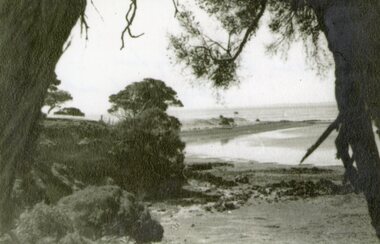
Photograph - Black and white landscape photograph of cove, c.1939
Churchill Island Heritage Farm has a large photograph collection dating from the mid-nineteenth century to the last decadeBlack and white landscape photograph of a cove taken from the shelter of trees.Catalogue number written in pencil on reverse. On reverse in pen '1939 Tide out from below the big dam looking towards north point'churchill island -
 Southern Sherbrooke Historical Society Inc.
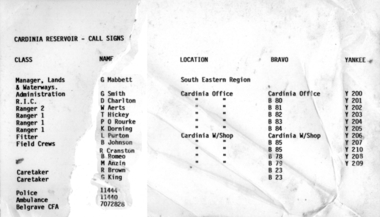
Information folder - Cardinia Reservoir
staff list donated to society by Dandenong Ranges Steiner SchoolInformation folder containing items pertaining to Cardinia Reservoir. Contents: -article "Huge Dam grows steadily", Sun, 3rd June 1975 (incomplete) -obituary of Allan Robertson, 'Dam fine infrastructure czar and community supporter', The Age, 10th December 2009 -staff list, Cardinia Reservoir, Melbourne & Metropolitan Board Of Works -trifold pamphlet, 'Cardinia Reservoir', Melbourne & Metropolitan Board of Works, n.d. but c.1973cardinia reservoir, melbourne & metropolitan board of works, allan gordon robertson, obe, oam, infrastructure, water -
 Greensborough Historical Society
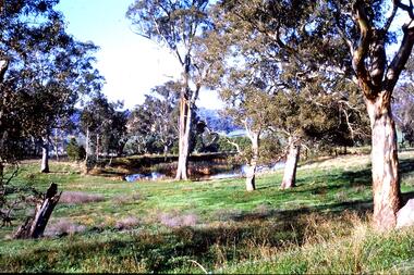
Slide - Photograph, John Ramsdale, Farmland Yallambie: Slide 49, 1990s
Photograph shows a rural landscape with gum trees and dam; this is near Yallambie on the Plenty River.Part of the John Ramsdale collection of slides and audio visual material.Colour photograph scanned from slide.No maker's marks. No caption on slide.plenty river, yallambie -
 Stawell Historical Society Inc
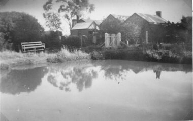
Photograph, Davidson Home in Deep Lead
Deep Lead – Portrait Davidson Home 1906-7. Home. 1947. With dam in foreground.stawell home -
 Otway Districts Historical Society
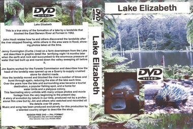
DVD, Lake Elizabeth, 2006
Lake Elizabeth was formed when a landslide slid into the valley damming the East Barwon River.Interviews with people who remember the formation of the Lake.30 Minute video of the creation of the lake in 1952lake elizabeth forrest east barwon -
 Federation University Historical Collection
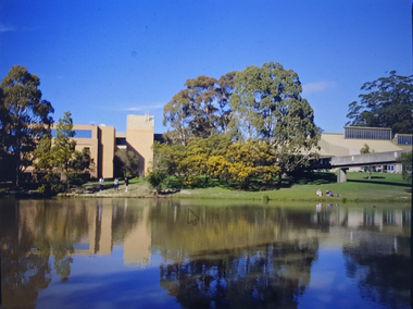
Photograph, Mt Helen Campus Looking South, c1993
Transparency of Mt Helen Campus looking towards the E.J. Barker Librarymt helen campus, dam, lake, mt helen library, e.j. barker library -
 Federation University Historical Collection
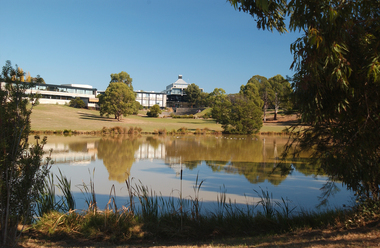
Photograph, Gippsland Campus, 2004
In 1989 Monash University took over the Gippsland Institute of Advanced Education to create Monash Gippsland Campus. In 2014 the University of Ballarat and the Churchill Campus of Monash University merged to become Federation University Australia.Photograph of the Federation University Gippsland Campus during its era as a campus of Monash University. gippsland campus collection, monash university gippsland campus, business school, churchill, dam -
 Federation University Historical Collection
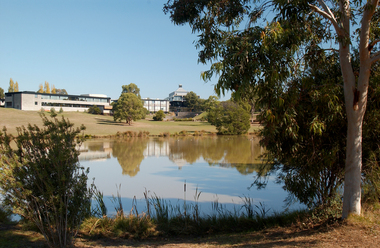
Photograph, Gippsland Campus, 2004
In 1989 Monash University took over the Gippsland Institute of Advanced Education to create Monash Gippsland Campus. In 2014 the University of Ballarat and the Churchill Campus of Monash University merged to become Federation University Australia.Photograph of the Federation University Gippsland Campus during its era as a campus of Monash University. gippsland campus collection, monash university gippsland campus, business school, churchill, dam -
 Kiewa Valley Historical Society
Photograph of Lake Guy and Bogong Village, Lake Guy and Bogong Village, Approx. 1945
In 1940 Field Headquarters for the Kiewa Scheme were established at Bogong with office, workshop facilities and accommodation for workmen, staff and some families constructed. (There had been a 'tent camp' on this site in 1939 but was destroyed by bushfires) Construction of accommodation continued until 1947. A total of 40 houses plus a hostel for single staff, post office, police station, medical centre and primary school all with water and sewerage and electricity supply. The staff hostel was known as Kiewa House and is now occupied by the Education Department. Lake Guy was named after Mr. L.T. Guy who was the Resident Engineer in charge of construction work and associated activities on the Kiewa area. He held this position from 1939 to November 1946 when he was transferred to Head Office.This photograph is an excellent historical record of Bogong Village in about 1945. It shows the layout of the town in the fairly steep terrain, the workmen's camp between the houses and the lake foreshore, the Commissioner's Lodge on the hill behind the Village, the walkway through the dam wall can be seen to the left of the spillway, the dam is on spill and note damage to the large trees is still evident from the 1939 bush fires. The Commissioner's Lodge was lost in the 2003 fires and the camp buildings were in service until 1962, when they were removed and the site converted into a public picnic area with lawns and gardens.A Black and white photograph"Lake Guy and Bogong" hand written on back of photograph.kiewa, accommodation, lake, dam, bogong -
 Glenelg Shire Council Cultural Collection
Photograph, CSR Softwoods/Dartmoor Mill, n.d
Port of Portland Authority archives.port of portland -
 Glenelg Shire Council Cultural Collection
Photograph, CSR Softwoods/Dartmoor Mill, n.d
Port of Portland Authority archives.port of portland -
 Glenelg Shire Council Cultural Collection
Photograph, CSR Softwoods/Dartmoor Mill, n.d
Port of Portland Authority archives.port of portland -
 Bendigo Historical Society Inc.
Photograph - PHOTOGRAPH FORTUNA VILLA AND MINES
Black and white photograph of Fortuna Villa mining sites, showing on foreground water dam, poppet head and chimney, Victoria Hill on the left. There are two copies one sepia colour.bendigo, mining, fortuna mine sites -
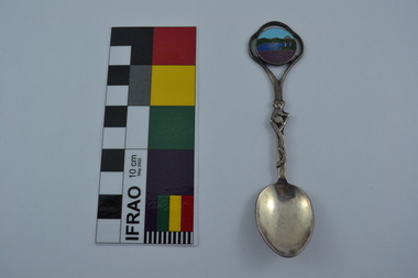 Melbourne Water
Souvenir Spoon
The Maroondah System was first and foremost developed as a functional component of Melbourne's Water Supply System. In addition to functionality, the Melbourne and Metropolitan Board of Works (MMBW) envisioned the Maroondah Reserve to be enjoyed aesthetically and recreationally by the public. This souvenir illustrates the realisation of the Maroondah System as a local recreational and tourist attraction in the early 20th century. The Maroondah Reserve gardens were landscaped with English-style ornamental stonework, exotic trees, flower beds and rose gardens. All features of the water supply system became widely celebrated as beauty spots that continue to be very popular to this day with tourists and locals alike. This souvenir is a product of that flourishing tourist trade. These water supply sites continue to enhance Melbourne’s charm and liveability and are now recognised as places of cultural and historic significance.This souvenir spoon has been curated by Melbourne Water as it represents an important historical aspect of the organisation by demonstrating the popularity of its water asset sites as recreational places and tourist attractions, and although these sites are functional parts of the water supply system, they were also designed to be enjoyed by the public both aesthetically and recreationally.Manufactured in Australia, this souvenir silver-plated spoon features an image of Maroondah Dam, Healesville. The spoon features a koala engraving and boomerang on the stem. Engraved on the back of the spoon is “Peninsula Plate”.mmbw, melbourne metropolitan board of works, spoon, souvenir, maroondah, healesville, melbourne water -
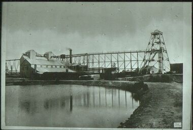 Bendigo Historical Society Inc.
Slide - ALBERT RICHARDSON COLLECTION: SOUTH NEW MOON GOLD MINE, EAGLEHAWK
Slide. South New Moon Gold Mine, situated west of Beezlebub Road, Eaglehawk. Poppet head, trestleway ,engine/boiler house, chimney stack, large dam in foreground .No. 24 on bottom of slidemine, gold, south new moon., bendigo mines-jack hattam collection -
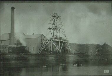 Bendigo Historical Society Inc.
Slide - ALBERT RICHARDSON COLLECTION: VICTORIA QUARTZ 1897
Slide. Hercules and Energetic Mine, Long Gully. Poppet head, chimney stack, mullock heaps, wood stack, engine house and boiler. Large dam in foreground with ducks and geese .No. 11 on bottom of slidemine, gold, unknown mine., bendigo mines-jack hattam collection -
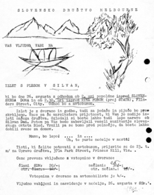 Slovenian Association Melbourne
Invitation to a dance, Invitation to an outing and a dance at Silvan 1962, 1962
Invitation to an outing and a Slovenian dance on 26th August 1962 at Silvan Dam. The invitation promises a transport by bus and an early return - before midnight - to make a connection by public transport home.Hand drawn pictures and typewritten textinvitiation, dance, silvan, 1962 -
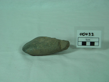 Bright & District Historical Society operating the Bright Museum
Axe Stone
Evidence of Aboriginal presence and activities in Buffalo River Valley near site of present Buffalo Dam.Evidence of Aboriginal presence and activities in North East and Alpine areas relatively uncommon.quartzite ground edge stone axe with edge damage axe, aboriginal artefact, buffalo river -
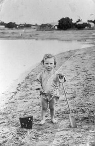 Stawell Historical Society Inc
Photograph, St George Battery dam.with Lindsay McDonald as the child
Young barefooted child with bucket and spade at St. George Battery dam. Child is Lindsay McDonaldstawell -
 Kiewa Valley Historical Society
7 small black and white photographs of Pretty Valley, c1948
In 1947 it was proposed to construct a dam on the Pretty Valley branch of the East Kiewa River. This was part of the initial planning in 1937. The Pretty Valley Reservoir was to be part of a pumped-storage scheme with a pumping station located immediately below the main structure. Preparatory work was commenced in 1946 with erection of staff accommodation. Between 1947 and 1950 the main camp was erected, access roads, constructed and banks and benches at the dam site undertaken. Following the financial crisis in 1951, a review of the scheme was carried out and work ceased in June 1951. Construction of the dam was deleted from the programme of works and all buildings removed.A pictorial history of part of the initial planning in 1937 for a dam to be constructed at Pretty Valley as part of the Kiewa Hydro Electric Scheme.7 small black and white photographs of Pretty ValleyAll photos have a circular stamp on the back with 'Print by Willson White Albury' enclosed. Photo 1 - on the back, handwritten in ink 'New 22Kv pump line - Pretty Valley Nov. 1948'. In pencil '18'. Photo 2 - On the back, handwritten in ink 'Pretty Valley - Staff mess on right Nov. 1948'. In pencil '18'. Photo 3 - On the back, handwritten in ink 'Pretty Valley Basin - looking S.E. Nov. 1948'. In pencil '5'. Photo 4 - On the back, handwritten in ink 'New pump 22Kv line, Pretty Valley - looking towards Mt. Mackie. Nov. 1948'. In pencil '5'. Photo 5 - On the back, handwritten in ink 'Pretty Valley. Mt. Cope just out of picture extreme right. Nov. 1948'. In pencil '78'. Photo 6 - on the back, handwritten in ink 'View from Pretty Valley Ruined Castle in Background Nov. 1948'. In pencil '78'. Photo 7 - on the back, handwritten in ink 'Pretty Valley Pump line (Nov. 1948)'. In pencil'78'.construct, dam, pretty valley -
 The Beechworth Burke Museum
Photograph, c.1927-1930
This image shows the Punt (a kind of small boat) that took residents of Bethanga across the Murray River before the Bethanga Bridge was built. Bethanga Bridge was built between 1927 and 1930, and was made a necessity by the building of the Hume Dam. The Hume Dam, formerly known as the Hume Weir, was in construction between 1919 and 1936, which swelled the Murray River into the floodplain to the East of the dam permanently, creating Lake Hume, and isolating the residents of Bethanga and nearby towns, for whom the trip all the way around the new lake to another river crossing was a massive undertaking. The person who wrote on the back of this card instead chose to cross the river on a boat until the Bethanga Bridge became available. Interestingly, partially submerged trees can be seen in the lake in the background of this photograph, illustrating that the dam had already begun to fill the floodplain even before the bridge was built. This photograph shows the methods the residents of Bethanga used while the Bethanga Bridge was being built. This record is associated with the Heritage Listed sites of the Hume Dam and the Bethanga Bridge, and shows the environment during the process of construction and the creation of Lake HumeSepia rectangular photograph printed on matte photographic paperReverse: 1997.3189 / 84 -19 -1 / This is the snap of the Punt. / Our only means of getting out / of Bethanga for the present / Until the bridge is completed / it is 2 miles above the junction / of the Mitta + Murray. It is / 1/2 a mile wide + runs across / the Murray into NSW / Kodak Print / bethanga, bethanga bridge, hume, hume dam, artificial lake, lake hume, hume weir, flood, floodplain, boat, punt, weir, pier, dock, transport, transportation -
 Kiewa Valley Historical Society
Photos - Junction Dam Spillway, Kiewa Hydro Electric Scheme
2 black and white small photos titled - A. 'Bogong Village, Kiewa Hydro Electric Project' and B. 'Junction Dam & Spillway, Lake Guy, Bogong, Kiewa Hydro Electric Project' -
Bendigo Historical Society Inc.
Map - SNOB'S HILL - PLAN OF SNOB'S HILL AREA
Plan drawn on tracing film of sand heap, dams, trig point and mines. Some un-named streets are also drawn in. Piece of notepaper has mines drawn in on a larger scale.map, bendigo, goldfields, snob's hill, plan of snob's hill area, new st mungo mullock heap, duchess trib, s devonshire, duchess of edinburough, w u devonshire, hopewell, phoenix, unicorn, princess alice, lady barkly, sadowa, e u devonshire, united devonshire, l?, ellenborough, belmont & saxby, snob's hill -
Tatura Irrigation & Wartime Camps Museum
Photograph, 1936
Photo taken by the photographer for Victoria State Rivers and Water Supply CommissionMedium sized black and white photograph. Eildon Weir spillway / Concrete structure of terraced steps and pylons supporting floodgates / rectangular tower on right / Dam water beyond at top of picture.goulburn, irrigation, photo, victoria state rivers and water supply commission, eildon, eildon weir -
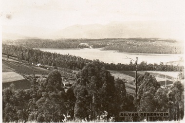 Southern Sherbrooke Historical Society Inc.
Postcard, Silvan Reservoir
Sepia-toned postcard featuring distant view of Silvan Dam. The middle ground shows cleared land all set out for agriculture, houses also visible. c. early 1930s -
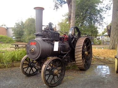 Puffing Billy Railway
Vehicle - Traction Engine - Foden Compound, 1914
Ordered by Langwill Bros., & Davies Ltd Melbourne Used for saw milling, dam constructions and log haulingFoden Traction Engine This engine is a compound traction engine built by Foden Ltd of Sandbach England in 1914 – builders number 4525. This was ordered by Langwill Bros and Davies Ltd of Melbourne and was used by Mr F Orr on his farm at Bullarto South Victoria. On the farm it was used for many agricultural purposes and was used at times as a stationary engine to run a wooden thrashing machine. The unit was last used on the farm in 1947 and put aside on the farm with a “museum” of other old agricultural tractors and machinery. Mr Orr gave us the engine as an exhibit for the Menzies Creek Museum of Puffing Billy in the 1960s. At that stage he was an elderly gentleman of 97 years and maintained a great interest in his farm which had been in his family’s hands for three generations at that stage. His grandfather had cut the farm from the bush. The traction engine in its youth was used to go around other farms in the district and went as far away as the Wimmera and Mallee farms thrashing crops of wheat, barley and oats. It towed the wooden thrashing machine behind it on its trips to these farms on hire to the farmers. Foden Compound Traction Engine Built by Foden Ltd., Sandback, England in 1914 to the order of Langwill Bros., & Davies Ltd., Melbourne, it was used on a farm for sawmilling, dam constructions and log hauling. Donated by F. Orr of Bullarto South, Victoria. Foden Compound Traction Engine - made of Steel (Painted)Foden foden, traction engine, steam, puffing billy -
Tatura Irrigation & Wartime Camps Museum
Folder, Recollections of Eildon
Recollections of construction of Eildon Dam and life in the township. Also contains 50 slide power point disc.Blue plastic cover. Black spine. White label- handwritten titlelocal history, water, irrigation, books, history, local, rural, industry -
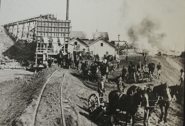 Wodonga & District Historical Society Inc
Photograph - Constructing the Hume Weir, c1928
This image is from Wodonga Historical Society's large collection of photographs documenting the construction of the Hume Dam during its initial construction and ongoing development. Hume Dam took 17 years to construct from the turning of the first sod on 28 November 1919 by Sir Ronald Munro-Ferguson, Governor-General of Australia. The first filling was in December 1934 and it was officially opened on 21 November 1936. Between 1950 and 1961 further modifications were made which enlarged its storage capacity. Progressive improvements have been made since that time to ensure the dam meets modern safety standards.This photo reflects a major stage in the construction of the Hume Dam.A large black and white image of construction of the Hume Weir on the Murray River mounted on board.hume dam construction, hume weir australia -
Tatura Irrigation & Wartime Camps Museum
Photograph, 13/04/1918
Taken by photographer for State Rivers and Water Supply Commission.Medium sized black and white photograph. Eildon Weir / Original structure 1918 / Rock and earth fill dam wall / concrete spillway (lower left) / Water middle distance / hills beyondgoulburn weir, victorian state rivers and supply commission