Showing 581 items matching " garden estate"
-
 Kew Historical Society Inc
Plan - Subdivision Plan, J R Mathers & McMillan, Normanby Estate, c.1913
The Kew Historical Society's map collection includes a substantial number of real estate subdivision plans, mainly of Kew but also of surrounding suburbs in Melbourne. Most of the subdivision plans date from the 1920s and 1930s when the districts old homes and local farmland were being split up to accommodate residential growth in the postwar period. These early plans were assembled by a local firm, Jas R Mather & McMillan, which had an office in Cotham Road. Many of the plans, and sometimes photos, were annotated by the agents.Subdivision plans are historically important documents used as evidence for the growth of suburbs in Australia. They frequently provide information about when the land was sold as well as evidence relating to surveyors and real estate and financial agents. The numerous subdivision plans in the Kew Historical Society's collection represent working documents, ranging from the initial sketches made in planning a subdivision to printed plans on which auctioneers or agents listed the prices for which individual lots were sold. In a number of cases, the reverse of a subdivision plan in the collection includes a photograph of a house that was also for sale by the agent. These photographs provide significant heritage information relating house design and decoration, fencing and household gardens.The photograph may also be aesthetically significant depending on the importance of the photographic atelier.The Normanby Estate, which was adjacent to Normanby Road, Kew East, included thirty-one lots for sale. Streets on the subdivision plan include Adeney Avenue, Park Hill Road, Normanby Road, Weir Street and Wharton Street. Cotham Road and its tramway are shown nearby. The plan is interesting as it shows Wharton Street, named after the architect and town planner George Wharton, who was the first chairman of the Municipality of Kew. The street was to later be renamed Cecil Street. Also shown are proposed ‘Municipal Gardens’ where Parkhill Drive is now located."D" in top left corner. Stamped auctioneers contact details: "Jas. R. Mathers & Son & McMillan / Auctioneer & Land Salesmen, / 271 Collins Street / Melbourne" and Jas. R. Mathers / Estate & Financial Agent / Cotham Road / Kew".weir street - kew, wharton street - kew, normanby road - kew, cotham road - kew, municipal gardens - kew, park hill parkhill road - kew, braemar - kew, subdivision plans - kew -
 Kew Historical Society Inc
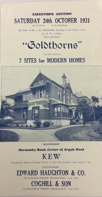
Document, Executor's Auction, Sunday 24th October 1931, "Goldthorns", Normanby Road, Corner of Argyle Road, Kew, 1931
Rare real estate brochure relating to the sale of a historically significant Kew mansion. The rarity the document is increased due to the photographs of the front of the house and of the extensive rear garden.Four page flyer advertising the sale of Goldthorns in Normanby Road, Kew in October 1931. The flyer contains a photograph of the front of the house, a list of its rooms, a site plan (including possible subdivisions). and a photo of the rear garden.goldthorns - normanby road, kew (vic), real estate - kew (vic), griffith family - kew (vic), gardens - kew (vic), subdivisions - kew (vic) -
 Kew Historical Society Inc
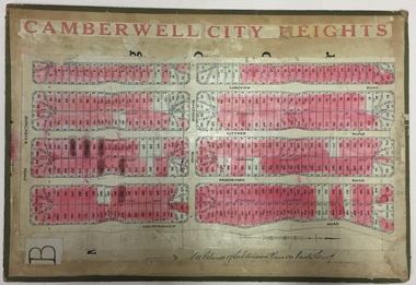
Plan - Subdivision Plan, Jas R Mathers Son & McMillan, Camberwell City Heights, 1922
"Following the 1919 amalgamation of suburban tramway trusts, an electrified tram service extended along Doncaster Road. Housing estates such as the 1919 Balwyn Park Estate, 1922 Hillcrest Estate and the Camberwell City Heights Estate, also 1922, quickly followed. These estates were built over by expansive suburban villas, set in fine gardens and along tree-lined streets. North Balwyn, largely constructed since 1933, was typified by even grander houses, many of them in the 'ocean liner' style and seen at their most distinctive in the Riverview Estate." (Source; 'Balwyn' in eMelbourne)Portions of subdivision plan mounted on both sides of cardboard sheet. Coloured pink, probably to show allotments sold. Area covered: Doncaster Road, Mountainview Road, Panoramic Road, Cityview Road, Longview Road, Riverview Road, Hillview Road, Bulleen Road. Includes location diagram showing railway lines and existing and proposed tram routes.Cardboard backing has advertisement for "Tillock's soluble coffee"subdivision plans -- camberwell (vic.), camberwell city heights subdivision -
 Kew Historical Society Inc
Archive (Sub-series) - Subject File, Kew Historical Society, 'Goldthorns' (Houses, Kew), 1958
... - kew (vic), goldthorns estate, mansion - kew (vic) gardens ...Various partiesReference, Research, InformationSecondary Values (KHS Imposed Order)Subject file containing Executor's Auction, Sunday 24th October 1931, "Goldthorns", Normanby Road, Corner of Argyle Road, Kew’ - Four page flyer advertising the sale of Goldthorns in Normanby Road, Kew in October 1931. The flyer contains a photograph of the front of the house, a list of its rooms, a site plan (including possible subdivisions) and a photo of the extensive rear garden.goldthorns - normanby road - kew (vic),, goldthorns estate, mansion - kew (vic), gardens - kew (vic), griffiths family, subdivisions - kew (vic)goldthorns - normanby road - kew (vic),, goldthorns estate, mansion - kew (vic), gardens - kew (vic), griffiths family, subdivisions - kew (vic) -
 Kew Historical Society Inc
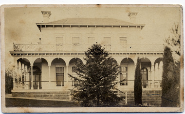
Photograph - 'Clutha', Studley Park Road, 1860-1890
Clutha was the home of John Carson, the second mayor of Kew. Leonard Terry designed the house for him in 1856. Terry was the architect of the Melbourne Club (1858), the former London Chartered Bank (1861), Lothian Terrace in Carlton (1865), and the ES&A Bank in Hawthorn (1873). The commission for Clutha was won three years after Terry’s arrival in Victoria.An extremely rare photograph of a major residential architectural commission of Leonard Terry. The photograph of the house has statewide significance as the home of the Victorian pioneer and businessman, John Carson. A rare, nineteenth century photograph of ‘Clutha’ in Studley Park Road, Kew. The sepia-toned photograph is of the front of the house, with its bluestone foundations and its second storey balcony. A real estate advertisement in 1875 described the house as: 'First-class family mansion, and about 8½ acres of pleasure grounds and fruit garden. The house, erected under the plans and supervision of Mr. Leonard Terry, is most substantially built of brick, stuccoed, on solid bluestone pediment, forming a noble basement story, large entrance hall, and lobby, with conservatory on the left. *** A wide verandah and balcony, erected on cast-iron columns, runs round the house, the views from which are perhaps unequalled in extent and beauty in the neighbourhood of the city, commanding the bay, shipping, Mount Macedon, and Dandenong Ranges. Th e whole forming a most complete gentleman's residence, no expense having been spared in its erection and comfortable finish.'"Clutha West Side Studley Park Road Kew / Clutha West Side"clutha, john carson, leonard terry -
Kew Historical Society Inc
Journal, Kew Historical Society, Newsletter No.137, December 2021
Civic Ephemera / Robert Baker p1. Office Bearers / p2. History News: Acquisitions; Exhibitions; Grants & Sponsors; Tribute - Dorothy Johanna Benyei 1926-2021 / p3. Boroondara's Private Schools 1851-1951 / John Torpey p4. Alexandra Gardens: a chronological and horticultural survey / Desley Reid p6. Discoveries and Inventions [Trinity Grammar School] / Brad Miles p8. Another Alan Sumner Window [Carey Grammar] / Felicity Renowden p8. Victorian Collections / Robert Baker p8. The Sale of the Halfey Estate: Ordsall [Southesk] and Hermosa [Northesk] / David White p9. Centenary of thew Model Dairy / Robert Baker p11. Membership & Donations p12.Published quarterly since 1977, the newsletters of the Kew Historical Society contain significant research by members exploring relevant aspects of the Victorian and Australian Framework of Historical Themes. Frequently, articles on people, places and artefacts are the only source of information about an aspect of Kew, and Melbourne’s history.non-fictionCivic Ephemera / Robert Baker p1. Office Bearers / p2. History News: Acquisitions; Exhibitions; Grants & Sponsors; Tribute - Dorothy Johanna Benyei 1926-2021 / p3. Boroondara's Private Schools 1851-1951 / John Torpey p4. Alexandra Gardens: a chronological and horticultural survey / Desley Reid p6. Discoveries and Inventions [Trinity Grammar School] / Brad Miles p8. Another Alan Sumner Window [Carey Grammar] / Felicity Renowden p8. Victorian Collections / Robert Baker p8. The Sale of the Halfey Estate: Ordsall [Southesk] and Hermosa [Northesk] / David White p9. Centenary of thew Model Dairy / Robert Baker p11. Membership & Donations p12.kew historical society (vic.) -- periodicals., kew historical society (vic.) -- newsletters, kew historical society (vic.) -- journals -
 Kew Historical Society Inc
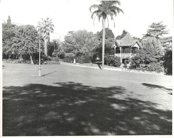
Photograph, Alexandra Gardens, c.1960
Rotunda, Alexandra Gardens (1910-c.1960). The Alexandra Gardens’ rotunda was located within three acres of ‘gem like’ gardens ‘bright with verdant lawns and choice blooms’ in the centre of Kew. Designed by architects Grainger and Little, the ornate two-storey wooden kiosk functioned as a children’s shelter on the ground level and a bandstand and oratory dais on the upper. Funded by council and community subscription, it was a ‘symbol of the public spirit of Victoria’ and a Kew Jubilee commemoration memorial. Opened in 1910, the Kew Brass Band christened it the ‘finest band rotunda in Melbourne’. Deterioration saw its demise 50 years later. This work forms part of the collection assembled by the historian Dorothy Rogers, that was donated to the Kew Historical Society by her son John Rogers in 2015. The manuscripts, photographs, maps, and documents were sourced by her from both family and local collections or produced as references for her print publications. Many were directly used by Rogers in writing ‘Lovely Old Homes of Kew’ (1961) and 'A History of Kew' (1973), or the numerous articles on local history that she produced for suburban newspapers. Most of the photographs in the collection include detailed annotations in her hand. The Rogers Collection provides a comprehensive insight into the working habits of a historian in the 1960s and 1970s. Together it forms the largest privately-donated collection within the archives of the Kew Historical Society.Lawn and original rotunda in the Alexandra Gardens, Cotham Road, Kew. The Alexandra Gardens were opened in 1908. The land on which the gardens were formed originally formed part of the Madford Estate. A feature of the gardens was a large brick, wood and tiled rotunda. "Alexandra Gardens. Formerly part of S. King. (Rest of Estate mainly belongs to St Anthonys home). Opened 1908. Alexandra Gardens. (Rotunda now demolished)"alexandra gardens, kew, dorothy rogers -
 Kew Historical Society Inc
Plan, Studley Heights Estate, 1936
Pru Sanderson, in her groundbreaking ‘City of Kew Urban Conservation Study : Volume 2 - Development History’ (1988), summarised the periods of urban development and subdivisions of land in Kew. The periods that she identified included 1845-1880, 1880-1893, 1893-1921, 1921-1933, 1933-1943, and Post-War Development. These periods were selected as they represented periods of rapid growth or decline in urban development. An obvious starting point for Sanderson’s groupings involved population growth and the associated economic cycles. These cycles also highlighted urban expansion onto land that was predominantly rural, although in other cases it represented the decline and breakup of large estates. A number of the plans in the Kew Historical Society’s collection can also be found in other collections, such as those of the State Library of Victoria and the Boroondara Library Service. A number are however unique to the collection.Subdivision plans are historically important documents used as evidence of the growth of suburbs in Australia. They frequently provide information about when the land was sold on which a built structure was subsequently constructed as well as evidence relating to surveyors and real estate and financial agents. The numerous subdivision plans in the Kew Historical Society's collection represent working documents, ranging from the initial sketches made in planning a subdivision to printed plans on which auctioneers or agents listed the prices for which individual lots were sold. In a number of cases, the reverse of a subdivision plan in the collection includes a photograph of a house that was also for sale by the agent. These photographs provide significant heritage information relating house design and decoration, fencing and household gardens.The ‘Studley Heights Estate’ on the South Side of Studley Park Road was launched in 1936. The seventeen allotments in the subdivision fronted Hyton Crescent and Studley Park Road.subdivision plans - kew, studley heights estate -
![Monnington [Estate], 1935](/media/collectors/550653872162f11fb04854aa/items/5907eb86d0ce0c14e82385c8/item-media/5907ecafd0ce0c14e823e87f/item-fit-380x285.jpg) Kew Historical Society Inc
Kew Historical Society IncPlan - Subdivision Plan, Monnington [Estate], 1935, 1935
Pru Sanderson, in her groundbreaking ‘City of Kew Urban Conservation Study : Volume 2 - Development History’ (1988), summarised the periods of urban development and subdivisions of land in Kew. The periods that she identified included 1845-1880, 1880-1893, 1893-1921, 1921-1933, 1933-1943, and Post-War Development. These periods were selected as they represented periods of rapid growth or decline in urban development. An obvious starting point for Sanderson’s groupings involved population growth and the associated economic cycles. These cycles also highlighted urban expansion onto land that was predominantly rural, although in other cases it represented the decline and breakup of large estates. A number of the plans in the Kew Historical Society’s collection can also be found in other collections, such as those of the State Library of Victoria and the Boroondara Library Service. A number are however unique to the collection.Subdivision plans are historically important documents used as evidence of the growth of suburbs in Australia. They frequently provide information about when the land was sold on which a built structure was subsequently constructed as well as evidence relating to surveyors and real estate and financial agents. The numerous subdivision plans in the Kew Historical Society's collection represent working documents, ranging from the initial sketches made in planning a subdivision to printed plans on which auctioneers or agents listed the prices for which individual lots were sold. In a number of cases, the reverse of a subdivision plan in the collection includes a photograph of a house that was also for sale by the agent. These photographs provide significant heritage information relating house design and decoration, fencing and household gardens.The first subdivision of Monnington took place in 1935. At that time, Monnington and 10 new allotments were offered for sale bordering Adeney and Marshall Avenues. In this subdivision plan, Monnington is one of 13 lots for sale. The subdivision created the irregular land holding of Monnington today. The excision of southwest corner of Monninton was caused by the need to have regular allotments facing the curve in Marshall Avenue.monnington - adeney avenue -- kew (vic.), subdivision plans -- kew (vic.) -
 Kew Historical Society Inc
Plan - Subdivision Plan, Wimba Estate, Kew, c.1925-c.1929, ca. 1925-ca. 1929
... as well as evidence relating to surveyors and real estate ...Pru Sanderson, in her groundbreaking ‘City of Kew Urban Conservation Study : Volume 2 - Development History’ (1988), summarised the periods of urban development and subdivisions of land in Kew. The periods that she identified included 1845-1880, 1880-1893, 1893-1921, 1921-1933, 1933-1943, and Post-War Development. These periods were selected as they represented periods of rapid growth or decline in urban development. An obvious starting point for Sanderson’s groupings involved population growth and the associated economic cycles. These cycles also highlighted urban expansion onto land that was predominantly rural, although in other cases it represented the decline and breakup of large estates. A number of the plans in the Kew Historical Society’s collection can also be found in other collections, such as those of the State Library of Victoria and the Boroondara Library Service. A number are however unique to the collection.Subdivision plans are historically important documents used as evidence of the growth of suburbs in Australia. They frequently provide information about when the land was sold on which a built structure was subsequently constructed as well as evidence relating to surveyors and real estate and financial agents. The numerous subdivision plans in the Kew Historical Society's collection represent working documents, ranging from the initial sketches made in planning a subdivision to printed plans on which auctioneers or agents listed the prices for which individual lots were sold. In a number of cases, the reverse of a subdivision plan in the collection includes a photograph of a house that was also for sale by the agent. These photographs provide significant heritage information relating house design and decoration, fencing and household gardens.In 1925, the City of Kew called for tenders for the construction of Wimba Avenue, Cadow Street and Lalla Street. Subsequent advertisements for the sale of land in Wimba Avenue continued from 1926 to 1929. The 18 lots (and a further five allotments on the eastern side of the street) offered for sale were unofficially described in the subdivision plan as the ‘Wimba Estate’. These lots began in Park Hill Road and extended almost to Cotham Road. The subdivision took its name from the house ‘Wimba’ in Cotham Road, which may have formed the southern boundary of the subdivision. (Wimba, at 235 Cotham Road was constructed between 1862-70). The Plan highlights the proximity and advantage of ‘electric’ trams in Cotham and Glenferrie Roads, and the Kew and Glenferrie Railway Stations. An oddity in the Plan is the reference to the electric tram terminus at Burke Road, given that the tramline had already been extended to Mont Albert in 1916.wimba estate, subdivision plans - kew, parkhill road – kew (vic.), normanby road – kew (vic.), wimba avenue – kew (vic.) -
 Kew Historical Society Inc
Plan, F R Simms & Son, Land for Private Sale: Cnr Victor Avenue and Mont Victor Road, Kew, 1950-1960
George Rimington established The Parkhill Nursery in 1877. By 1910, it was more commonly known as Rimington’s Nurseries and well known for its sale of violets. After World War II, Rimington’s Nurseries were gradually subdivided and sold. The 38 allotments were released in sections, including lots 34 to 36 on the corner of Mont Victor Road and Victor Avenue. Previous lots in the subdivision had bordered Burke Road, Rimington Avenue, Heather Grove, and Stoke Avenue. The selling point as it had been in comparable estates for a century were the proximity to transport, schools and churches, as well as the high location and excellent views. The subdivision plan shows most of the lots in the entire subdivision: 1-11, 13-26, and 34-38. Presumably, lot 12 and lots 27-33 were still to be released.Subdivision plans are historically important documents used as evidence of the growth of suburbs in Australia. They frequently provide information about when the land was sold on which a built structure was subsequently constructed as well as evidence relating to surveyors and real estate and financial agents. The numerous subdivision plans in the Kew Historical Society's collection represent working documents, ranging from the initial sketches made in planning a subdivision to printed plans on which auctioneers or agents listed the prices for which individual lots were sold. In a number of cases, the reverse of a subdivision plan in the collection includes a photograph of a house that was also for sale by the agent. These photographs provide significant heritage information relating house design and decoration, fencing and household gardens.Subdivision plan advertising five superb home sites among lots in Burke Road, Stoke Avenue, Victor Avenue, Mont Victor Road and Heather Grove.subdivision plans - kew, rimington avenue -- kew (vic.), heather grove -- kew (vic), stoke avenue -- kew (vic.), burke road -- kew (vic.), mont victor road -- kew (vic.) -
 Kew Historical Society Inc
Plan - Subdivision Plan, Six Big Home Sites, Camberwell North, c.1936
Subdivision plans are historically important documents used as evidence of the growth of suburbs in Australia. They frequently provide information about when the land was sold on which a built structure was subsequently constructed as well as evidence relating to surveyors and real estate and financial agents. The numerous subdivision plans in the Kew Historical Society's collection represent working documents, ranging from the initial sketches made in planning a subdivision to printed plans on which auctioneers or agents listed the prices for which individual lots were sold. In a number of cases, the reverse of a subdivision plan in the collection includes a photograph of a house that was also for sale by the agent. These photographs provide significant heritage information relating house design and decoration, fencing and household gardens.A subdivision in what is currently Balwyn, but which was advertised as being in Camberwell North. The subdivision included six allotments facing Buchanan Avenue and Houghton Street. The subdivision was to the east of the Pointed Firs Estate (1936). In addition to the intrinsic value of this subdivision plan, it also reveals information about the development of transport infrastructure in this area. The subdivision plan notes that the Tramways Board has approved the extension of the tram route past the current terminus at Balwyn Road.subdivision plans - camberwell -
 Kew Historical Society Inc
Plan - Subdivision Plan, Glenferrie Road & Wellington St, Kew, c.1920s
Subdivision plans are historically important documents used as evidence of the growth of suburbs in Australia. They frequently provide information about when the land was sold on which a built structure was subsequently constructed as well as evidence relating to surveyors and real estate and financial agents. The numerous subdivision plans in the Kew Historical Society's collection represent working documents, ranging from the initial sketches made in planning a subdivision to printed plans on which auctioneers or agents listed the prices for which individual lots were sold. In a number of cases, the reverse of a subdivision plan in the collection includes a photograph of a house that was also for sale by the agent. These photographs provide significant heritage information relating house design and decoration, fencing and household gardens.An unnamed subdivision in Kew including eleven lots for sale bordering Glenferrie Road, Wellington Street and Franks Grove.subdivision plans - kew, franks grove, wellington street, glenferrie road -
 Kew Historical Society Inc
Plan - Subdivision Plan, Windella-Darnley Subdivision, Studley Park, 1920s
Subdivision plans are historically important documents used as evidence of the growth of suburbs in Australia. They frequently provide information about when the land was sold on which a built structure was subsequently constructed as well as evidence relating to surveyors and real estate and financial agents. The numerous subdivision plans in the Kew Historical Society's collection represent working documents, ranging from the initial sketches made in planning a subdivision to printed plans on which auctioneers or agents listed the prices for which individual lots were sold. In a number of cases, the reverse of a subdivision plan in the collection includes a photograph of a house that was also for sale by the agent. These photographs provide significant heritage information relating house design and decoration, fencing and household gardens.Version 1 of two subdivision plans (the later one is MAP.0027) for the section of Studley Park Road near the Junction on the south side. Named in the subdivision are the mansions of Darley and Windella (now demolished). Before the subdivision of Darley and Windella, both houses fronted Studley Park Road. Both houses appear to be advertised as lots in the subdivision. Bisecting the subdivision is a street, Antrim Avenue that was never constructed. A street, which was subsequently constructed in this vicinity, was Merrion Place, which now runs between Studley Park Road and Highfield Grove. There are 14 proposed lots in this subdivision."Antrim Avenue. See over for new plan"subdivision plans - kew, studley park, windella, darnley, studley park road -- kew (vic.), merrion place -- kew (vic.), merrion grove -- kew (vic.), highbury grove -- kew (vic.) -
 Kew Historical Society Inc
Plan - Subdivision Plan, Windella-Darnley Subdivision, Studley Park, 1920s
Subdivision plans are historically important documents used as evidence of the growth of suburbs in Australia. They frequently provide information about when the land was sold on which a built structure was subsequently constructed as well as evidence relating to surveyors and real estate and financial agents. The numerous subdivision plans in the Kew Historical Society's collection represent working documents, ranging from the initial sketches made in planning a subdivision to printed plans on which auctioneers or agents listed the prices for which individual lots were sold. In a number of cases, the reverse of a subdivision plan in the collection includes a photograph of a house that was also for sale by the agent. These photographs provide significant heritage information relating house design and decoration, fencing and household gardens.Version 2 of two subdivision plans (the earlier is 2016.0305.1) for the section of Studley Park Road near the Junction on the south side. Named in the subdivision are the mansions of Darley and Windella (now demolished). Before the subdivision of Darley and Windella, both houses fronted Studley Park Road. Both houses appear to be advertised as lots in the subdivision. Bisecting the subdivision is a street, Antrim Avenue that was never constructed. A street, which was subsequently constructed in this vicinity, was Merrion Place, which now runs between Studley Park Road and Highfield Grove. There are 13 proposed lots in this subdivision in contrast to the earlier plan. This resulted from larger lots being proposed for Studley Park Road.subdivision plans - kew, studley park, windella, darnley, antrim avenue -- kew (vic.), studley park road -- kew (vic.), merrion place -- kew (vic.), merrion grove -- kew (vic.), highbury grove -- kew (vic.) -
 Kew Historical Society Inc
Plan - Subdivision Plan, Shop Sites, East Kew, c.1927
Subdivision plans are historically important documents used as evidence of the growth of suburbs in Australia. They frequently provide information about when the land was sold on which a built structure was subsequently constructed as well as evidence relating to surveyors and real estate and financial agents. The numerous subdivision plans in the Kew Historical Society's collection represent working documents, ranging from the initial sketches made in planning a subdivision to printed plans on which auctioneers or agents listed the prices for which individual lots were sold. In a number of cases, the reverse of a subdivision plan in the collection includes a photograph of a house that was also for sale by the agent. These photographs provide significant heritage information relating house design and decoration, fencing and household gardens.This is one of a small number of subdivision plans for commercial property in the collection. The subdivision proposed to create six shop sites in High Street between the Harp of Erin and Station Street. The plan shows this stretch of High Street, East Kew already lined with shops that include the hotel on the corner, the new State Savings Bank, a dentist’s surgery and Lambert’s Store. The High Street Tram was to reach Burke Road in 1925, so the proposed subdivision must postdate that event, and the opening of the Bank in 1926.subdivision plans - east kew, high street - east kew -
 Kew Historical Society Inc
Plan - Subdivision Plan, Eastlawn Estate, 1914
Subdivision plans are historically important documents used as evidence of the growth of suburbs in Australia. They frequently provide information about when the land was sold on which a built structure was subsequently constructed as well as evidence relating to surveyors and real estate and financial agents. The numerous subdivision plans in the Kew Historical Society's collection represent working documents, ranging from the initial sketches made in planning a subdivision to printed plans on which auctioneers or agents listed the prices for which individual lots were sold. In a number of cases, the reverse of a subdivision plan in the collection includes a photograph of a house that was also for sale by the agent. These photographs provide significant heritage information relating house design and decoration, fencing and household gardens.The ‘Eastlawn Estate’ was surveyed and ready for auction in March 1914, three months before the outbreak of World War I. Sixty-six allotments, created on the ‘order of Mr & Miss Preston’ surrounded the mansion of Woodlands in Harp Road. Woodlands formed part of the Estate, being advertised as lot 1. The allotments faced High, Station and Wright Streets, Harp and Normanby Roads, and Woodlands Avenue. Pru Sanderson in the Kew Conservation Study (Vol.2, 1988) wrote that the Eastlawn Estate ‘covered the western half of the failed Harp of Erin Estate’. Contemporary advertisements promoted the Eastlawn Estate as: ‘There will be no more convenient district nor pleasant Suburb than East Kew for the busy business man. When the Electric Tram is laid, he will be able to journey quickly and pleasantly direct from Collins Street to his home in the Eastlawn Estate in about 20 minutes’. The actual plans of subdivision were included in advertisements in The Argus and in the local newspapers.subdivision plans - east kew, eastlawn estate -
 Kew Historical Society Inc
Plan - Subdivision Plan, Raheen Estate Subdivision, 1960
Subdivision plans are historically important documents used as evidence of the growth of suburbs in Australia. They frequently provide information about when the land was sold on which a built structure was subsequently constructed as well as evidence relating to surveyors and real estate and financial agents. The numerous subdivision plans in the Kew Historical Society's collection represent working documents, ranging from the initial sketches made in planning a subdivision to printed plans on which auctioneers or agents listed the prices for which individual lots were sold. In a number of cases, the reverse of a subdivision plan in the collection includes a photograph of a house that was also for sale by the agent. These photographs provide significant heritage information relating house design and decoration, fencing and household gardens.The Raheen Estate Subdivision of 1960 involved the creation of 36 residential allotments and the sale of 34 of these. The land on which the subdivision was created had until 1960 formed part of the grounds of the mansion Raheen in Studley Park Road. In 1917, the Catholic Church had purchased Raheen and its lands. It was to become the home of Archbishop of Melbourne, Daniel Mannix, for 46 years. The sale of the subdivision took place three years before the Archbishop’s death. Subsequent archbishops were to reside at Raheen until its sale to the Pratt family in 1981. When the sale of the Estate was reported in the newspapers in 1960, it was described as the last big subdivision near Melbourne. At the auction, 33 of the 36 allotments were sold. The auction realised £315,750. Purchasers were advised that the vendor intended to keep lots 22 and 23. The alllotments in the subdivision required the construction of new roads. These included Eamon Court and Raheen Drive. The justification provided by the Church for the sale was that the estate was being sold to finance school building projects.subdivision plans - kew, studley park, raheen estate, eamon court, studley park road, coombes avenue, raheen drive -
 Kew Historical Society Inc
Plan - Subdivision Plan, Oswinia Estate, East Kew, c.1925
Prue Sanderson, in her groundbreaking ‘City of Kew Urban Conservation Study : Volume 2 - Development History’ (1988), summarised the periods of urban development and subdivisions of land in Kew. The periods that she identified included 1845-1880, 1880-1893, 1893-1921, 1921-1933, 1933-1943, and Post-War Development. These periods were selected as they represented periods of rapid growth or decline in urban development. An obvious starting point for Sanderson’s groupings involved population growth and the associated economic cycles. These cycles also highlighted urban expansion onto land that was predominantly rural, although in other cases it represented the decline and breakup of large estates. A number of the plans in the Kew Historical Society’s collection can also be found in other collections, such as those of the State Library of Victoria and the Boroondara Library Service. A number are however unique to the collection.Subdivision plans are historically important documents used as evidence of the growth of suburbs in Australia. They frequently provide information about when the land was sold on which a built structure was subsequently constructed as well as evidence relating to surveyors and real estate and financial agents. The numerous subdivision plans in the Kew Historical Society's collection represent working documents, ranging from the initial sketches made in planning a subdivision to printed plans on which auctioneers or agents listed the prices for which individual lots were sold. In a number of cases, the reverse of a subdivision plan in the collection includes a photograph of a house that was also for sale by the agent. These photographs provide significant heritage information relating house design and decoration, fencing and household gardens.The ‘Oswinia Estate’ subdivision in East Kew was planned and auctioned in the first half of the 1920s. 169 allotments were created in the triangular section of land bordered by High Street, Burke Road and the Government Boulevard (later Kilby Road). The only piece of land excluded was that where the previous Kew Pound had been located at the east tip of the triangle. Allotments were created fronting Glass, High, Namur, Oswin Streets, Irymple Avenue, and the Government Boulevard. The name for the Estate was derived from Oswin’s farm, which had been one of the largest landholdings in East Kew. The selling agents annotated the plan in our collection with crosses indicating those lots that had been sold. The inset locality plan is particularly interesting as it shows the route and stations of the Outer Circle Railway. When the subdivision plan was created, it included the proposed bridge over the Yarra at Burke Road. The bridge was to be officially opened in 1926.subdivision plans - east kew, oswinia estate, high street, glass street, namur street, government boulevard - kilby road, irymple street, oswin street -
 Kew Historical Society Inc
Plan - Subdivision Plan, 6 Choice Residential Allotments: East Kew, 1932
Prue Sanderson, in her groundbreaking ‘City of Kew Urban Conservation Study : Volume 2 - Development History’ (1988), summarised the periods of urban development and subdivisions of land in Kew. The periods that she identified included 1845-1880, 1880-1893, 1893-1921, 1921-1933, 1933-1943, and Post-War Development. These periods were selected as they represented periods of rapid growth or decline in urban development. An obvious starting point for Sanderson’s groupings involved population growth and the associated economic cycles. These cycles also highlighted urban expansion onto land that was predominantly rural, although in other cases it represented the decline and breakup of large estates. A number of the plans in the Kew Historical Society’s collection can also be found in other collections, such as those of the State Library of Victoria and the Boroondara Library Service. A number are however unique to the collection.Subdivision plans are historically important documents used as evidence of the growth of suburbs in Australia. They frequently provide information about when the land was sold on which a built structure was subsequently constructed as well as evidence relating to surveyors and real estate and financial agents. The numerous subdivision plans in the Kew Historical Society's collection represent working documents, ranging from the initial sketches made in planning a subdivision to printed plans on which auctioneers or agents listed the prices for which individual lots were sold. In a number of cases, the reverse of a subdivision plan in the collection includes a photograph of a house that was also for sale by the agent. These photographs provide significant heritage information relating house design and decoration, fencing and household gardens.The mansion Woodlands in Harp Road, East Kew suffered the death of a thousand cuts. In its case, the cuts were subdivisions. Previous subdivisions of the mansion and its grounds were given titles such as ‘The Eastlawn Estate’ (MAP.0055), whereas at the end, the subdivision called it as it was, naming itself the ‘final section of the Woodlands Estate’ when it was put up for auction in 1932. The emphasis in the promotion of the subdivision was that it provided purchasers with splendid opportunities ‘to build modern homes in select, well established modern surroundings’. As with other subdivisions in the interwar period, transport links were emphasised. The six residential lots cut Woodlands off from Harp Road. When the vendor, Louisa Rachel Preston Hill, was to die at Woodlands in 1937 aged 86 her address was given as Normanby Road.subdivision plans - kew, woodlands estate -
 Kew Historical Society Inc
Plan, J R Mathers & McMillan, 5 Splendid vVlla Allotments,: Segtoune St. & Windsor St., Kew, 1928
Prue Sanderson, in her groundbreaking ‘City of Kew Urban Conservation Study : Volume 2 - Development History’ (1988), summarised the periods of urban development and subdivisions of land in Kew. The periods that she identified included 1845-1880, 1880-1893, 1893-1921, 1921-1933, 1933-1943, and Post-War Development. These periods were selected as they represented periods of rapid growth or decline in urban development. An obvious starting point for Sanderson’s groupings involved population growth and the associated economic cycles. These cycles also highlighted urban expansion onto land that was predominantly rural, although in other cases it represented the decline and breakup of large estates. A number of the plans in the Kew Historical Society’s collection can also be found in other collections, such as those of the State Library of Victoria and the Boroondara Library Service. A number are however unique to the collection.Subdivision plans are historically important documents used as evidence of the growth of suburbs in Australia. They frequently provide information about when the land was sold on which a built structure was subsequently constructed as well as evidence relating to surveyors and real estate and financial agents. The numerous subdivision plans in the Kew Historical Society's collection represent working documents, ranging from the initial sketches made in planning a subdivision to printed plans on which auctioneers or agents listed the prices for which individual lots were sold. In a number of cases, the reverse of a subdivision plan in the collection includes a photograph of a house that was also for sale by the agent. These photographs provide significant heritage information relating house design and decoration, fencing and household gardens.In 1928, five residential allotments bordering Segtoune and Windsor Streets were advertised for sale as part of a subdivision. Four of the blocks faced Segtoune Avenue. The auctioneers proclaimed the advantages of the sites: ‘Situate one minute from the High Street Electric Tram, which now runs direct to Spencer Street via Bridge Road and Flinders Street. Opposite the East Kew Railway Station (Outer Circle Line), which may be reopened In connection with the new Line from Kew to Doncaster; Adjacent lo the Kew Recreation Reserve, Sports Oval, and Swimming Bath; Half Minute from the Shopping Centre of East Kew, Accessible to the State School and Other Educational Centres’. The Harp of Erin Hotel and the route of the Outer Circle Railway line are marked on the plan. The Recreation Reserve and Sport Oval refer to Victoria Park. The Swimming Baths were located on the site of the current Kew Recreation Centre.subdivision plans - kew, segtoune street -- kew (vic.), windsor street -- kew (vic.) -
 Kew Historical Society Inc
Plan - Subdivision Plan, Plan of Subdivision of Crown Portion 71, Parish of Boroondara LP12509, Vol.1678, Fol.335526, Before 1930
Prue Sanderson, in her groundbreaking ‘City of Kew Urban Conservation Study : Volume 2 - Development History’ (1988), summarised the periods of urban development and subdivisions of land in Kew. The periods that she identified included 1845-1880, 1880-1893, 1893-1921, 1921-1933, 1933-1943, and Post-War Development. These periods were selected as they represented periods of rapid growth or decline in urban development. An obvious starting point for Sanderson’s groupings involved population growth and the associated economic cycles. These cycles also highlighted urban expansion onto land that was predominantly rural, although in other cases it represented the decline and breakup of large estates. A number of the plans in the Kew Historical Society’s collection can also be found in other collections, such as those of the State Library of Victoria and the Boroondara Library Service. A number are however unique to the collection.Subdivision plans are historically important documents used as evidence of the growth of suburbs in Australia. They frequently provide information about when the land was sold on which a built structure was subsequently constructed as well as evidence relating to surveyors and real estate and financial agents. The numerous subdivision plans in the Kew Historical Society's collection represent working documents, ranging from the initial sketches made in planning a subdivision to printed plans on which auctioneers or agents listed the prices for which individual lots were sold. In a number of cases, the reverse of a subdivision plan in the collection includes a photograph of a house that was also for sale by the agent. These photographs provide significant heritage information relating house design and decoration, fencing and household gardens.The six lots on the south side of Macartney Avenue, between Macartney Avenue and Daniell Place were part of a subdivision that occurred before 1930. The subdivision plan is of interest in that the original name of Daniell Place was Brougham Place. On the Plan, it is noted that lots 5 and 6 (currently 10 and 12 Macartney Avenue) had been sold for £13 each. By November 1930, the new six-roomed villa built on 12 Macartney Avenue was offered for immediate sale at a ‘sacrifice price’. Any offer in reason would be considered, although a £350 deposit was required.subdivision plans - kew, mount street - kew, brougham street - kew , macartney avenue - kew -
 Kew Historical Society Inc
Plan - Subdivision Plan, Mont Victor Hill Estate, 1936
... as well as evidence relating to surveyors and real estate ...Pru Sanderson, in her groundbreaking ‘City of Kew Urban Conservation Study : Volume 2 - Development History’ (1988), summarised the periods of urban development and subdivisions of land in Kew. The periods that she identified included 1845-1880, 1880-1893, 1893-1921, 1921-1933, 1933-1943, and Post-War Development. These periods were selected as they represented periods of rapid growth or decline in urban development. An obvious starting point for Sanderson’s groupings involved population growth and the associated economic cycles. These cycles also highlighted urban expansion onto land that was predominantly rural, although in other cases it represented the decline and breakup of large estates. A number of the plans in the Kew Historical Society’s collection can also be found in other collections, such as those of the State Library of Victoria and the Boroondara Library Service. A number are however unique to the collection.Subdivision plans are historically important documents used as evidence of the growth of suburbs in Australia. They frequently provide information about when the land was sold on which a built structure was subsequently constructed as well as evidence relating to surveyors and real estate and financial agents. The numerous subdivision plans in the Kew Historical Society's collection represent working documents, ranging from the initial sketches made in planning a subdivision to printed plans on which auctioneers or agents listed the prices for which individual lots were sold. In a number of cases, the reverse of a subdivision plan in the collection includes a photograph of a house that was also for sale by the agent. These photographs provide significant heritage information relating house design and decoration, fencing and household gardens.A preliminary plan for the Mont Victor Hill subdivision of 1936 which included 23 allotments bordering the Rimington Nursery in Mont Victor Road. The subdivision created allotments in Victor Avenue, Heather Grove and Burke Road. Bisecting the Estate and clearly marked on the plan is the Railway Reserve which at this stage was all that remained of the Outer Circle Railway. The auctioneers note on the plan that the subdivision was made possible by the order of Messrs S. H. Bennet & H. Wright, the executors of the Wills of S. Bennett & E. Foreman.mont victor hill estate, subdivision plans - kew -
 Kew Historical Society Inc
Plan - Subdivision Plan, Riversdale Estate, 1939
The Kew Historical Society collection includes almost 100 subdivision plans pertaining to suburbs of the City of Melbourne. Most of these are of Kew, Kew East or Studley Park, although a smaller number are plans of Camberwell, Deepdene, Balwyn and Hawthorn. It is believed that the majority of the plans were gifted to the Society by persons connected with the real estate firm - J. R. Mathers and McMillan, 136 Cotham Road, Kew. The Plans in the collection are rarely in pristine form, being working plans on which the agent would write notes and record lots sold and the prices of these. The subdivision plans are historically significant examples of the growth of urban Melbourne from the beginning of the 20th Century up until the 1980s. A number of the plans are double-sided and often include a photograph on the reverse. A number of the latter are by noted photographers such as J.E. Barnes.The Riversdale Estate in Hawthorn created a subdivision of 20 allotments bordering on Riversdale Road and Riversdale Court (which was created by the subdivision). The Locality Plan at right lists the major public buildings in the area: Burnely Horticultural Gardens, Hawthorn Tram Depot and Railway Station, Scotch College and the River Yarra and The Boulevard.subdivision plans - hawthorn, riversdale estate -
 Kew Historical Society Inc
Plan - Subdivision Plan, Normanby Estate, East Kew, 1913
Pru Sanderson, in her groundbreaking ‘City of Kew Urban Conservation Study : Volume 2 - Development History’ (1988), summarised the periods of urban development and subdivisions of land in Kew. The periods that she identified included 1845-1880, 1880-1893, 1893-1921, 1921-1933, 1933-1943, and Post-War Development. These periods were selected as they represented periods of rapid growth or decline in urban development. An obvious starting point for Sanderson’s groupings involved population growth and the associated economic cycles. These cycles also highlighted urban expansion onto land that was predominantly rural, although in other cases it represented the decline and breakup of large estates. A number of the plans in the Kew Historical Society’s collection can also be found in other collections, such as those of the State Library of Victoria and the Boroondara Library Service. A number are however unique to the collection.The Kew Historical Society collection includes almost 100 subdivision plans pertaining to suburbs of the City of Melbourne. Most of these are of Kew, Kew East or Studley Park, although a smaller number are plans of Camberwell, Deepdene, Balwyn and Hawthorn. It is believed that the majority of the plans were gifted to the Society by persons connected with the real estate firm - J. R. Mathers and McMillan, 136 Cotham Road, Kew. The Plans in the collection are rarely in pristine form, being working plans on which the agent would write notes and record lots sold and the prices of these. The subdivision plans are historically significant examples of the growth of urban Melbourne from the beginning of the 20th Century up until the 1980s. A number of the plans are double-sided and often include a photograph on the reverse. The Normanby Estate, which was adjacent to Normanby Road, Kew East, included thirty-one lots for sale. Streets on the subdivision plan include Adeney Avenue, Park Hill Road, Normanby Road, Weir Street and Wharton Street. Cotham Road and its tramway are shown nearby. The plan is interesting as it shows Wharton Street, named after the architect and town planner George Wharton, who was the first chairman of the Municipality of Kew. The street was to later be renamed Cecil Street. Also shown are proposed ‘Municipal Gardens’ where Parkhill Drive is now located.subdivision plans - kew, normanby estate -
 Kew Historical Society Inc
Plan - Subdivision Plan, Tregarron Estate, Kew, c.1929
Pru Sanderson, in her groundbreaking ‘City of Kew Urban Conservation Study : Volume 2 - Development History’ (1988), summarised the periods of urban development and subdivisions of land in Kew. The periods that she identified included 1845-1880, 1880-1893, 1893-1921, 1921-1933, 1933-1943, and Post-War Development. These periods were selected as they represented periods of rapid growth or decline in urban development. An obvious starting point for Sanderson’s groupings involved population growth and the associated economic cycles. These cycles also highlighted urban expansion onto land that was predominantly rural, although in other cases it represented the decline and breakup of large estates. A number of the plans in the Kew Historical Society’s collection can also be found in other collections, such as those of the State Library of Victoria and the Boroondara Library Service. A number are however unique to the collection.Subdivision plans are historically important documents used as evidence of the growth of suburbs in Australia. They frequently provide information about when the land was sold on which a built structure was subsequently constructed as well as evidence relating to surveyors and real estate and financial agents. The numerous subdivision plans in the Kew Historical Society's collection represent working documents, ranging from the initial sketches made in planning a subdivision to printed plans on which auctioneers or agents listed the prices for which individual lots were sold. In a number of cases, the reverse of a subdivision plan in the collection includes a photograph of a house that was also for sale by the agent. These photographs provide significant heritage information relating house design and decoration, fencing and household gardens.In January 1929, the Kew City Council called for tenders to construct Tregarron Avenue. The subdivision of the Tregarron Estate in Kew was for 11 lots bordering Tregarron Avenue and its entrance from Burke Road. The plan includes annotations that indicate the measurement of each block and the placement of the drainage and sewerage easements. This plan is interesting for a number of factors. The house blocks today have different street numbers, some blocks were to be further subdivided, and at the time of the subdivision, alterations were still being made to the extent of lots offered; lots 2 and 3 on the plan were subdivided and reoriented.subdivision plans - kew, tregarron estate, tregarron avenue -- kew (vic.), burke road -- kew (vic.) -
 Kew Historical Society Inc
Map - Subdivision Plan, Grenville Estate, 1922
Pru Sanderson, in her groundbreaking ‘City of Kew Urban Conservation Study : Volume 2 - Development History’ (1988), summarised the periods of urban development and subdivisions of land in Kew. The periods that she identified included 1845-1880, 1880-1893, 1893-1921, 1921-1933, 1933-1943, and Post-War Development. These periods were selected as they represented periods of rapid growth or decline in urban development. An obvious starting point for Sanderson’s groupings involved population growth and the associated economic cycles. These cycles also highlighted urban expansion onto land that was predominantly rural, although in other cases it represented the decline and breakup of large estates. A number of the plans in the Kew Historical Society’s collection can also be found in other collections, such as those of the State Library of Victoria and the Boroondara Library Service. A number are however unique to the collection.Subdivision plans are historically important documents used as evidence of the growth of suburbs in Australia. They frequently provide information about when the land was sold on which a built structure was subsequently constructed as well as evidence relating to surveyors and real estate and financial agents. The numerous subdivision plans in the Kew Historical Society's collection represent working documents, ranging from the initial sketches made in planning a subdivision to printed plans on which auctioneers or agents listed the prices for which individual lots were sold. In a number of cases, the reverse of a subdivision plan in the collection includes a photograph of a house that was also for sale by the agent. These photographs provide significant heritage information relating house design and decoration, fencing and household gardens.In advertising the twenty-two sites of the Grenville Estate in Cotham Road and Alfred Street, Kew, the auctioneers emphasised the proximity of the development to shops, schools, and churches. That mansions surrounded the Estate was publicised as an added attraction. The plan shows how at this stage A regrettable aspect of this plan is that it is pasted over, and obscures a real estate photograph by the Kew photographer Josiah Earl Barnes.subdivision plans - kew, grenville estate, glenferrie road, alfred street, thomas street, cotham road -
 Kew Historical Society Inc
Plan - Subdivision Plan, Forres Estate, East Kew, 1919, 1919
Pru Sanderson, in her groundbreaking ‘City of Kew Urban Conservation Study : Volume 2 - Development History’ (1988), summarised the periods of urban development and subdivisions of land in Kew. The periods that she identified included 1845-1880, 1880-1893, 1893-1921, 1921-1933, 1933-1943, and Post-War Development. These periods were selected as they represented periods of rapid growth or decline in urban development. An obvious starting point for Sanderson’s groupings involved population growth and the associated economic cycles. These cycles also highlighted urban expansion onto land that was predominantly rural, although in other cases it represented the decline and breakup of large estates. A number of the plans in the Kew Historical Society’s collection can also be found in other collections, such as those of the State Library of Victoria and the Boroondara Library Service. A number are however unique to the collection.Subdivision plans are historically important documents used as evidence of the growth of suburbs in Australia. They frequently provide information about when the land was sold on which a built structure was subsequently constructed as well as evidence relating to surveyors and real estate and financial agents. The numerous subdivision plans in the Kew Historical Society's collection represent working documents, ranging from the initial sketches made in planning a subdivision to printed plans on which auctioneers or agents listed the prices for which individual lots were sold. In a number of cases, the reverse of a subdivision plan in the collection includes a photograph of a house that was also for sale by the agent. These photographs provide significant heritage information relating house design and decoration, fencing and household gardens.An annotated subdivision plan for the Forres Estate, Kew East. The estate was advertised in 1919, the Melbourne Auctioneers being represented locally by Henry Kellett, Estate Agent of High Street, Kew. The name of the estate was derived from the mansion (demolished 2016) of the same name in Normanby Road, which was at one stage owned by the Mayor of Kew, Cr. J. S. Were.subdivision plans - kew, forres estate, argyle road, simpson street, hubert street, normanby road -
 Kew Historical Society Inc
Plan - Subdivision Plan, St Helliers Estate, Kew, circa 1910, c.1910
Pru Sanderson, in her groundbreaking ‘City of Kew Urban Conservation Study : Volume 2 - Development History’ (1988), summarised the periods of urban development and subdivisions of land in Kew. The periods that she identified included 1845-1880, 1880-1893, 1893-1921, 1921-1933, 1933-1943, and Post-War Development. These periods were selected as they represented periods of rapid growth or decline in urban development. An obvious starting point for Sanderson’s groupings involved population growth and the associated economic cycles. These cycles also highlighted urban expansion onto land that was predominantly rural, although in other cases it represented the decline and breakup of large estates. A number of the plans in the Kew Historical Society’s collection can also be found in other collections, such as those of the State Library of Victoria and the Boroondara Library Service. A number are however unique to the collection.Subdivision plans are historically important documents used as evidence of the growth of suburbs in Australia. They frequently provide information about when the land was sold on which a built structure was subsequently constructed as well as evidence relating to surveyors and real estate and financial agents. The numerous subdivision plans in the Kew Historical Society's collection represent working documents, ranging from the initial sketches made in planning a subdivision to printed plans on which auctioneers or agents listed the prices for which individual lots were sold. In a number of cases, the reverse of a subdivision plan in the collection includes a photograph of a house that was also for sale by the agent. These photographs provide significant heritage information relating house design and decoration, fencing and household gardens.In the subdivision of part of Crown Portion 82, bordered by John and Sackville Streets and Cotham and Burke Roads, over 100 lots were offered for sale. In addition to the designated lots, a number of key locations are also identified. These include the Genazzano Convent to the north of Cotham Road, the Reservoir, St Hilary’s and the land holding of Colonel Parnell on the corner of John Street and Cotham Road. On the Plan, No. 5064, is the handwritten name ‘St. Hellier’s Estate’. St. Helliers, the home of the Dumaresq family is shown beside St. Hilary’s.subdivision plans - kew, st helliers estate -
 Kew Historical Society Inc
Plan - Subdivision Plan, Jas R Mathers Son & McMillan, Macartney Estate, East Kew, c. 1925
Pru Sanderson, in her groundbreaking ‘City of Kew Urban Conservation Study : Volume 2 - Development History’ (1988), summarised the periods of urban development and subdivisions of land in Kew. The periods that she identified included 1845-1880, 1880-1893, 1893-1921, 1921-1933, 1933-1943, and Post-War Development. These periods were selected as they represented periods of rapid growth or decline in urban development. An obvious starting point for Sanderson’s groupings involved population growth and the associated economic cycles. These cycles also highlighted urban expansion onto land that was predominantly rural, although in other cases it represented the decline and breakup of large estates. A number of the plans in the Kew Historical Society’s collection can also be found in other collections, such as those of the State Library of Victoria and the Boroondara Library Service. A number are however unique to the collection.Subdivision plans are historically important documents used as evidence of the growth of suburbs in Australia. They frequently provide information about when the land was sold on which a built structure was subsequently constructed as well as evidence relating to surveyors and real estate and financial agents. The numerous subdivision plans in the Kew Historical Society's collection represent working documents, ranging from the initial sketches made in planning a subdivision to printed plans on which auctioneers or agents listed the prices for which individual lots were sold. In a number of cases, the reverse of a subdivision plan in the collection includes a photograph of a house that was also for sale by the agent. These photographs provide significant heritage information relating house design and decoration, fencing and household gardens.The Macartney Estate subdivision advertised 21 lots for sale on either side of Macartney Street (now Macartney Avenue) and Evans Road in what was then designated as East Kew. Most of the houses shown on the south side of Macartney Street then, as now, have rear entrances on Mount Street, however a number of these blocks have since been further subdivided to allow for the building of new houses on the rear of a block. Brougham Place is marked on the plan but is now called Daniell Place."C"subdivision plans - east kew, macartney estate, macartney street, mount street, evans road, brougham place