Showing 1773 items
matching maps and plans
-
 Eltham District Historical Society Inc
Book, D. Pendavingh, Yarra River Trail Plan 1989: Banksia Street to Warrandyte, 1989
Also contains a loose A3 mylar plan inserted - Depart of Planning and Urban Growth, Heidelberg; Main Yarra Trail; Warringal Parklands and Banyule Flats, Detail Plan and Locality Plan -
 Federation University Historical Collection
Book, City of Ballaarat Planning Scheme Review: Planning Policies Identification Summary Report, 1980, 02/1980
Brown soft covered book outlining the City of Ballarat Planning Scheme Review . Includes black and white images and a map.city of ballaarat, city of ballarat planning, planning scheme review, map -
 Bendigo Historical Society Inc.
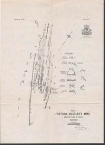
Map - STRUGNELL COLLECTION: HUSTLER'S LINE OF REEFS, BENDIGO, September 1913
Map, Hustler's Line of Reefs, Fortuna Hustler's Mine, Plan, Plate No.11(2).Bulletin No 33 Signed H.A.Whitelaw.Underground Survey Office, Bendigo.map, bendigo, fortuna hustler's mine -
Port Melbourne Historical & Preservation Society
Map - Melbourne and suburbs, MMBW, 8 Dec 1909
MMBW map of Melbourne and suburbs - Record plan up to July 1st 1913 (scale 3/4" = 1 mile)engineering - board of works, calder e oliver, russwaul(?) -
 Bendigo Historical Society Inc.
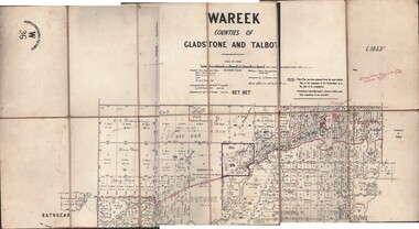
Map - JACK FLYNN COLLECTION: WAREEK, Examined 1918
Map: L.1053. Parish of Wareek, Counties of Gladstone and Talbot. Parish plan. Looks like half of the sheet is missing.Second Issue. Examined by S.F. Green. July 1918. William J. Swan, Draughtsman, August 1884. Photo-Lithographic Fac-Simile, W 36.map, gladstone, parish plan, wareek -
Whitehorse Historical Society Inc.
Map, Schwerkolt property by Arthur Schwerkolt, 1993
Map of Schwerkolt property and rough plan of original stone house produced by Arthur Schwerkolt. Also copy of covering letterschwerkolt cottage -
Lakes Entrance Historical Society
Book, Regional Coordination Group and Strategy Steering Committee, The East Gippsland Planning and Development Strategy, 1997
An outline of planning and proposed development by the East Gippsland, Victoria, Shire Council from 1997 to the year 2010. Maps included.township, land settlement, tourism -
 Bendigo Historical Society Inc.
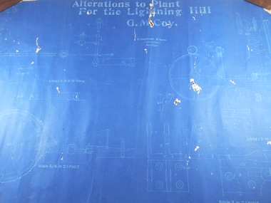
Administrative record - Lightning Hill Coy
Draftsman's drawing Alterations to Lightning Hill Coy plan Map. Forms part of the Margaret Roberts Collection of mining records.bendigo, margaret roberts, gold, map, mine, lightning hill coy -
 Bendigo Historical Society Inc.
Map - EPSOM ?, Circa 1880
Map: Parish plan showing an area Southwards from the parish of Huntly boundary, Covering Epsom,Ascot and White Hillsmap, bendigo, parish plan, epsom, ascot, white hills -
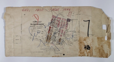 Bendigo Historical Society Inc.
Map - NEILBOROUGH RAVENSWOOD, October 21 1859
Map:Township of Neilborough, Elysian Flat, near Sandhurst,County unnamed. Parish plan. Backing is a part of Ravenswood Township map.map, bendigo, neilborough, elysian flat, ravenswood -
 Bacchus Marsh & District Historical Society
Map, Coimadai Parish Map, County of Bourke. Circa 1890s-1900s
The cadastral Parish of Coimadai, a subdivision of the County of Bourke, lies directly north of the township of Bacchus Marsh. The date of this map is uncertain. T.F. McGauran the person who made a photo-lithographic copy of the map was in charge of photo-lithography at the Victorian Department of Lands and Survey in the late 19th century until about 1910.A single page paper map showing the map for the Parish of Coimadai in the County of Bourke. A cadastral map showing parish boundaries and land ownership. A rectangle shaped area is missing from the centre of the map due to a tear or deliberate excision. The map is pasted into a bound volume containing 76 maps or plans in total. High resolution digital image stored on BMDHS computer network. Photo-lithographed at the Department of Lands and Survey, Melbourne by T.F. McGauran 26.8.[??] NOTE. Photo litho from L.P showing temporary surveys and occupation of land prepared for departmental use onlybacchus marsh region parish plans, coimadai parish maps, coimadai parish plan -
 Bacchus Marsh & District Historical Society
Map, Tracing of plan shewing portion through Bacchus Marsh District of proposed new Main Road between Gisborne and Blackwood
Road construction and planning was a primary function of the early local government authorities in rural and regional Victoria. This plan is indicative of the sort of documentation which generated considerable public interest and comment in rural communities. The date of this plan is not clear. Newspaper articles in the Bacchus Marsh Express around 1869 contain numerous references to the proposed new road between Gisborne and Blackwood which suggests this plan may date from the late 1860s or early 1870s.A single page paper map showing the proposed route of a main road to be constructed between Gisborne and Blackwood. The map is pasted into a bound volume containing 76 maps or plans in total. High resolution digital image stored on BMDHS computer network. roads, road plans, bacchus marsh victoria maps, gisborne to blackwood main road -
Clunes Museum
Plan - PLAN/MAP, SOUTH CLUNES GOLD MINE
... PLANS ...PLAN AND MAP OF SOUTH CLUNES GOLDMINEPLAN OF SOUTH CLUNES UNITED G.M.CO.CLUNES PRODUCED OR DRAWN BY F.W.NIVEN & CO LITH BALLARATlocal history, document, mining, plans -
 Kew Historical Society Inc
Plan - Framed Subdivision Plan (copy), F Price, Plan of Mr William Derrick's Land, Kew being Subdivision of Part of Section 86, Parish of Boroondara, County of Bourke, 1872, 1872
William Derrick was an early landowner in Kew, and with James Venn Morgan and James Dannock the purchaser of the parcel of land bounded by Cotham Road, High Street and Mary Street. Derrick Street in Kew is named after him.Map mounted under perspex. ‘Plan of Mr Willia Derrick's Land, Kew being Subdivision of Part of Section 86, Parish of Boroondara, County of Bourke’. This is a copy of the plan held in the State Library of Victoria.kew subdivision plan, john derrick, subdivision plans -- kew (vic.) -
Bendigo Historical Society Inc.
Map - CAMPBELL COLLECTION: BENDIGO AND DISTRICT MAPS, 12-2-29
Map. Axedale, Parish of Ellesmere and Axedale, Total area 4156 acres, Prepared in W.P.B. from A. and P. Plans by W.J. Galbraith 12-2-29. (number 383 in map cupboard 1)W.J.Galbraithmap, bendigo, agricultural lands -
Bendigo Historical Society Inc.
Map - CAMPBELL COLLECTION: BENDIGO AND DISTRICT MAPS, 15-2-29
Map. Nerring, Parish of Nerring, scale 20 chains to 1 inch. Prepared in W.P.B. from A. and P. Plans by W.J. Galbraith. 15-2-29. (number 379 in map cupboard 1)W.J.Galbraithmap, bendigo, agricultural lands -
Bendigo Historical Society Inc.
Map - CAMPBELL COLLECTION: BENDIGO AND DISTRICT MAPS, 15-2-29
Map. Nerring, Parish of Nerring, scale 20 chains to 1 inch. Prepared in W.J.B. from A and B plans by W.J. Galbraith 15-2-29. (number 356 in map cupboard 1)W.J.Galbraithmap, bendigo, parish plan -
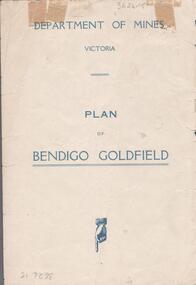 Bendigo Historical Society Inc.
Map - BENDIGO GOLDFIELDS MAP
Map of the Bendigo Goldfield, showing reef lines, mines and significant geographical features such as Monument Hill, Quartz Hill and Diamond Hill. On the back of map 'Department of Mines, Victoria. Plan of Bendigo Goldfield.bendigo, mining, bendigo goldfields -
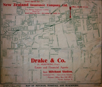 Kew Historical Society Inc
Map - Street Map, R L Jarrett, Map of Mitcham, Tunstall and Blackburn, 1929
Tunstall was originally the name of Nunawading Railway Station. Tunstall opened on 4 June 1888 and was renamed on 1 November 1945. An historically significant advertising map that can be used to ascertain the extent of urban development in 1929 in the areas of Nunawading, Blackburn and Mitcham.A map of Mitcham, Tunstall and Blackburn found on the reverse of a real estate subdivision plan published by R. L. Jarrett of Elizabeth Street. This promotional street map is overprinted with the business address of the sponsors and advertising. Map overlaid in red print: "Drake & Co. / (N. Armstrong, Prop.) / Estate and Financial Agents / next Mitcham Station / Established 1914. Open all day Saturday. / Phones: Office, Box Hill 289 J. / Private, Vermont 10."real estate agents, mitcham, tunstall, blackburn, road maps, drake & co, new zealand insurance co ltd -
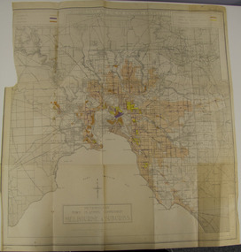 Glen Eira City Council History and Heritage Collection
Map - Map, zoning, Metropolitan Town Planning Commission, "DISTRIBUTION AND USE OF EXISTING PROPERTY. MAP NO. 6.", 1929
The map titled: “Distribution and use of Existing property map No. 6” (Metropolitan Town Planning Commission Melbourne and Suburbs) is of historical significance. It is listed on page 168 of Chapter 4 the Zoning section of the "Plan of General Development Melbourne Report of the Metropolitan Town Planning Commission 1929" - Melbourne's first strategic plan. Map No. 6 is mentioned throughout Chapter 4 of the 1929 Report. It states on page 156 that this Map was created to graphically illustrate the data collected by the Planning Commission. The Map illustrates the general distribution of uses of existing property throughout the metropolitan area. The coloured sections show the areas which were developed or were in the process of development in 1929. The colours indicate the distribution of uses in the developed areas. The pink coloured areas, which include Caulfield, were almost completely residential.1929, metropolitan town planning commission, melbourne, suburbs -
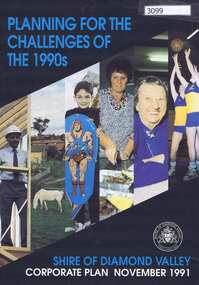 Greensborough Historical Society
Pamphlet, Planning for the challenges of the 1990s: Shire of Diamond Valley Corporate Plan, 1991_11
Shire of Diamond Valley Corporate Plan 1991. Includes Shire map and statistics with plans for services to the community.16p. text and coloured photographsshire of diamond valley -
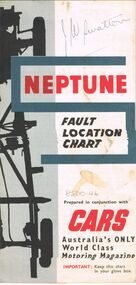 Bendigo Historical Society Inc.
Map - J W SWATTON COLLECTION: MAPS
Seven maps of various sizes. Map of the City of Ballarat, Victoria, Road Condition Map of Victoria including Melbourne-Cairns & Melbourne-Adelaide, Neptune Fault Location Chart, Grampians District Map, Racv Tour Planning Map Showing Road Conditions for Victoria, NSW and Queensland and Mt Macedon & District. Two of the maps have J W swatton & J Swatton written on them.j w swatton collection, racv, mobil, neptune, a r blair, j ewins & sons pty ltd, berry anderson & co -
Bendigo Historical Society Inc.
Map - CAMPBELL COLLECTION: BENDIGO AND DISTRICT MAPS
Map. Eppalock, Sedgwick and Strathfieldsaye, scale 20 chains to 1 inch. Road to Bendigo 13 1/2 miles at top right of map, Longlea Railway Station 5 1/2 miles, Bendigo 11 miles, Strathfieldsaye 5 miles on left of map. Total area 3972 acres. Prepared in W.P.B. from Assessment Plan and Parish Plans. H.A. Darby 14-6-29.H.A.Darbymap, bendigo, agricultural lands -
 Federation University Historical Collection
Book, The Old Pioneers' Memorial History of Melbourne From the Discovery of Port Phillip to the World War, 1924
Blue hard covered book of 494 pages. Images, and a large plan of prominent burials in the Melbourne Old Cemetery, and a Map of Melbourne. melbourne, melbourne cemetery, melbourne old cemetery, john batman, edmund hobson, batman's map, st francis' church, james balfour, mrs hornbrook, paddy's market, wilson hall, working men's college, henry kendall, le souef's cottage, world war one, westernport, melbourne cup, hoddle, collingwood, south melbourne, prahran, richmond, kew, brunswick, coburg, preston, hawthorn, camberwell, nunawading, doncaster, st kilda, brighton, sandringham, cheltenham, caulfield, oalkleigh, footscray, sunshine, north melbourne, carlton, ballarat school of art library, ballarat technical art school, book plate, library plate, hume and hovell's overland journey 1824-5, major mtichell's overland journey, australia felix, booplate, aborigine, aboriginal, captain cook, arthur phillip, isaac smith, george bass, matthew flinders, john murray, catain baudain, captain collins, edward henty, portalnd, map od melbourne in 1938, john pascoe fawkner, the "enterprise: and fawkner's first home, old colonists' homes, rushall crescent north fitszroy, richard bourke, the old melbourne post offfice, old governmnt house, toorak, latrobe's house at jolimont, first melbourne land sale, melbourne water supply, peter henry smith, victorian legislative council opening, map of melbourne and collingwood, prince's bridge, crossing the rivers by punt, f.a> rucker, canvas city emerald hill, arrival of the gold escort in melbourne, the yarra, queen's wharf, tall ships, old st james, mary e. budd, st francis church, michael carr, meolbourne city mission, state library of victoria, melbourne public library, bourke street, angus mcmilan, methodist ladies college, ormond college, armistance celebrations, robert russell, mia mia, theatre royal bouke st, melbourne from flaggstaff hill, federal coffee palace collins st, lord melbourne, melbourne mint, old melbourne town hall, robert russell's melbourne and yarra falls, mandevalle hall, point lansdale lighthouse, wilson's promontory, margaret m. ward cole, williamstown, flinders st melbourne, queenscliff battery, broadmeadows soldiers' camp, embarkation of first troops on the 'ceramic', general monsash, ian hamilton, general bridges, victorian war memorial, national war memorial, st kilda pier, first melbourne cup, hoddle's grid, albert park, melbourne mechanic's institute, st kilda toll gate, munted policeman, springthorpe memorial, james bonwick, mornane's paddock, victorian railways melbourne and surburban lines, carlton gardens, thomas napier, wiliam westgarth, george augustus robinson, william lonsdale, elizabeth mary batman, peomena frances darling batman, dig tree, exhibition of 1854, exhibition of 1866, exhibition buildings, geelong harbour, jubilee lake, port campbell, warrnambool, queenscliff lightboat, batman's first house -
Whitehorse Historical Society Inc.
Map, Parish of Boroondara and Parish of Nunawading, 1850
... Maps ...Photocopy of manuscript map.Photocopy of manuscript map. Note on verso: Plan of 22 portions marked in the Parish of Boroondara and 6 portions in the Parish of Nunawading c1850Photocopy of manuscript map. maps, parish of boroondara, parish of nunawading -
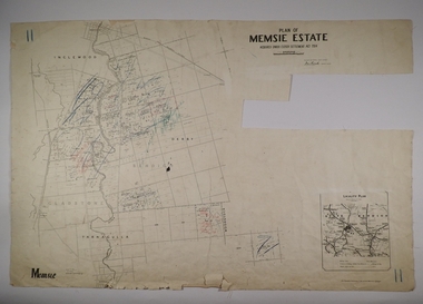 Bendigo Historical Society Inc.
Map - MEMSIE ESTATE, 26/08/1905
Map:Plan of Memsie estate, aquired under Closer Settlement Act 1904. Parish plan. Map dated 26/08/1905.map, estate, memsie estate, closer settlement act 1904. -
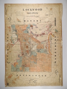 Bendigo Historical Society Inc.
Map - LOCKWOOD, 13/03/1876
Map: Lockwood, County of Bendigo. Parish plan. Compiled Jan. 1876. W. P. Lake Draftsman. paper on canvas backing.map, bendigo, parish plan, lockwood, w. p. blake -
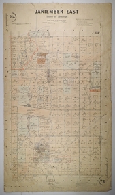 Bendigo Historical Society Inc.
Map - JANIEMBER EAST, 26/07/1879
Map: Janiember East, County of Bendigo. Parish plan Examined by T Pures 16.10.75 S M Reed August 1875map, bendigo, parish plan, janiember east, serpentine -
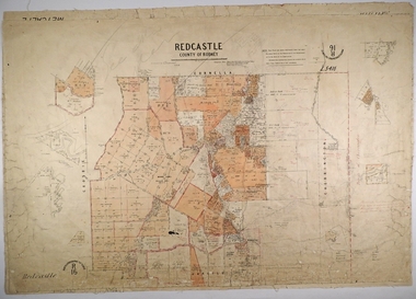 Bendigo Historical Society Inc.
Map - REDCASTLE, 15/10/1878
Map: Redcastle, County of Rodney. Parish plan. Examined E. D. Downward 28.9.78 T, S Hall Aug 78map, rodney, parish plan, redcastle, t. s. hall, e. d. downward -
 Bacchus Marsh & District Historical Society
Map, Village allotments, Parish of Myrniong, County of Bourke
Myrniong is a village 9 kilometers west of Bacchus Marsh. Prior to 1863 the area was known as Blow's Flat. This map which was produced in 1903 and according to the catalogue record of this map held at the State Library of Victoria was based on an earlier map created in 1861. The early layout of streets for the village of Myrniong can be seen on this map. The streets shown are, Main Street, Hardy Street, Blow Street, Myrniong Street, Shuter Street, and Blackwood Street. An area marked as a reserve for a school can be seen between Hardy Street and Main Street.A single page paper map. A cadastral parish map of Myrniong in Victoria, showing numbered land allotments. Photo-lithographed at the Department of Lands & Survey, Melbourne, in 1903. Based on an original map created in 1861. The map is pasted into a bound volume containing 76 maps or plans in total. High resolution digital image stored on BMDHS computer network. Surveyed by John Hardy, Surveyor ; photo-lithographed at the Department of Lands & Survey, Melbourne by T.F. McGauran, 24.12.03myrniong parish plan, myrniong parish maps