Showing 495 items
matching market st
-
 City of Greater Bendigo - Civic Collection
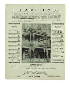
Flyer, Bolton Brothers Printers, J.H. Abbott & Co, c 1880
In 1867 J.H. Abbott established the New Times Boot Market & Factory in Pall Mall, Sandhurst. In 1867, his wife Anne took over running the shop which was located next to the Bendigo Arcade near Williamson Street and was successful in creating a successful business. In 1876, the leather business of T. Baulderstone was purchased, and operations were further expanded later by the acquisition of the Edinburgh Tannery at Sheepwash Creek, and The Edinburgh Leather & Grindery warehouse in Bull Street, Sandhurst. In 1889, Joseph Abbott passed all interests in the business to his son, who shared the same name, in partnership with an adopted son, Richard Hartley Smith Abbott. The business continued trading under the name J. H. Abbott & Co. A number of branches of the business had been established in the early 1900s. In 1959 the Pall Mall business relocated to 291 Hargreaves Street. The whole business was soon after consolidated and conducted from the Market Square branch (Lyttleton Terrace) as the Abbott Supply Company. Harold Abbott, the last of the family to work in the business, died in 1979. In 1980 the business shifted to a new purpose-built store and warehouse on the corner of Abel & Deborah Streets, Bendigo. Sandhurst Trustees administered the business from 1979 until its sale in 1986. He was elected to the Sandhurst Borough Council and in 1860 became chairman of the municipality.Two single colour printed gatefold flyer on green paper advertising J.H. Abbott and Co.'s boot and shoe store on Pall Mall Bendigo. Contains information on products and the fitting services provided in store for customers. chairman of sandhurst borough, anne abbott, city of greater bendigo commerce -
 City of Greater Bendigo - Civic Collection
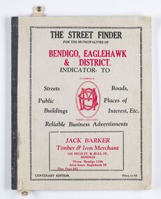
Book - Street Directory, McConnell Publisher, The Street Finder
General district street, business and services directory aimed less at the tourist market and more at the Bendigo and Eaglehawk population. Includes advertising. Index is extensive and includes services such as child care centres, cemeteries, theatres and schools.Thirty two page, printed and bound street and business directory for Bendigo, Eaglehawk and district. Grey card front cover with grey cardboard back cover. Printed in red and black ink. Includes Index for trades, streets and services such as banks, baths, sporting clubs and police stations. Majority of content is text and advertising and the only map included in the publication is printed inside the back cover.The Street Finder / for the municipalities of / Bendigo, Eaglehawk / & District. city of greater bendigo commerce, city of greater bendigo community groups, city of greater bendigo tourism, borough of eaglehawk, making a nation exhibition -
 City of Greater Bendigo - Civic Collection
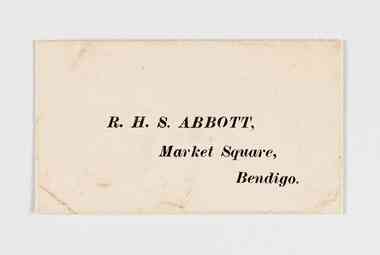
Document - Envelope, RHS Abbott
Richard Hartley Smith Abbott was the step son of Joseph Henry Abbott and inherited his families business interests, building successful commercial enterprises such as Abbott Supply Co. He was elected a representative in the Mandurang riding in the Shire of Strathfieldsaye in 1887, served as Mayor of the City of Bendigo from 1917 - 1918 and a member of the legislative Council of Victoria. He was Secretary of the Bendigo Art Gallery for over 20 years.Small envelope with RHS Abbott address printed on front. Open at back. R. H. S. Abbott, / Market Square, / Bendigo.mayor rhs abbott, shire of strathfieldsaye, bendigo art gallery, city of greater bendigo commerce -
 City of Greater Bendigo - Civic Collection
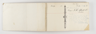
Book - Bound correspondence, RHS Abbott, c 1890
Joseph Henry Abbott arrived in Australia from Birmingham England in 1852 aged 22 hoping to make his fortune on the goldfields. In 1853 he opened a store in Bendigo, Abbott and Co and from there began a lengthy career as a business man supplying the local community with goods and services including owning and operating the New Times Boot Market & Factory in Pall Mall, Sandhurst, run by his wife, Anne (nee Deague). J H Abbott’s main ambitions were to serve on the local and state councils. He was elected Chairman of the Sandhurst Borough Council in 1860, Mayor of the City of Bendigo in 1891 and was gazetted a Justice of the Peace in 1864. Over his lifetime J H Abbott was closely linked to nearly all the leading institutions in Bendigo and worked for the benefit of local charities. He was trustee of the Bendigo Art Gallery and a Freemason and was said to be the first person in Bendigo to have a telephone installed in1882 between his residence and his business in Pall Mall. After JH Abbott died in 1904 he passed on his businesses to his son JH Abbott Jnr and adopted son RHS Abbott. These businesses continued to trade under the name JH Abbott & Co and today still operates under the name Abbott Supply although the last of the family interests ceased in 1986. Richard Hartley Smith Abbott was the step son of Joseph Henry Abbott and continued on in the family tradition of entering into business, becoming a successful business man. He also held asperations to serve on local council and was elected a representative in the Mandurang riding in the Shire of Strathfieldsaye in 1887, served as Mayor of the City of Bendigo from 1917 - 1918 and was Secretary of the Bendigo Art Gallery for over 20 years. Like this father he continued to build local industries with a particular interest in tanning selling products locally and exporting to London. The Tannery (in Tannery Lane, Mandurang) was one of the largest in the state. Large general correspondence book used by J H Abbott Co to issue reminders for accounts overdue and to place orders with suppliers. Book is bound with marbled front and back cover. Each page is perforated with the right side being printed with J H Abbott & Co Merchants and designed to be issued to receiver. Designed to use be used with carbon paper placed between two pages to create multiple copies of paperwork. Dated 1916 - 1917.city of greater bendigo commerce, mayor abbott, making a nation exhibition, shire of strathfieldsaye -
 City of Greater Bendigo - Civic Collection
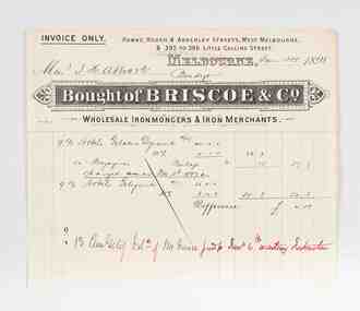
Financial record - Invoice, Briscoe & Co, 1898
Joseph Henry Abbott arrived in Australia from Birmingham England in 1852 aged 22 hoping to make his fortune on the goldfields. In 1853 he opened a store in Bendigo, Abbott and Co and from there began a lengthy career as a business man supplying the local community with goods and services including owning and operating the New Times Boot Market & Factory in Pall Mall, Sandhurst, run by his wife, Anne (nee Deague). J H Abbott’s main ambitions were to serve on the local and state councils. He was elected Chairman of the Sandhurst Borough Council in 1860, Mayor of the City of Bendigo in 1891 and was gazetted a Justice of the Peace in 1864. Over his lifetime J H Abbott was closely linked to nearly all the leading institutions in Bendigo and worked for the benefit of local charities. He was trustee of the Bendigo Art Gallery and a Freemason and was said to be the first person in Bendigo to have a telephone installed in1882 between his residence and his business in Pall Mall. After JH Abbott died in 1904 he passed on his businesses to his son JH Abbott Jnr and adopted son RHS Abbott. These businesses continued to trade under the name JH Abbott & Co and today still operates under the name Abbott Supply although the last of the family interests ceased in 1986. Abbott and Co acted as agents for larger Melbourne based suppliers such as Briscoe & Co and the Australian Explosives & Chemical Co. Printed and handwritten paper invoice from Briscoe & Co to JH Abbott & Co dated Jan 31st, 1898 for the purchase of dynamite and gelynite.city of bendigo mayor, shire of strathfieldsaye, mayor abbott, city of greater bendigo commerce, making a nation exhibition, briscoe & co -
 City of Greater Bendigo - Civic Collection
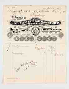
Financial record - Invoice, The Australian Explosives & Chemical Co, The Australian Explosives & Chemical Coy Ltd, 1898
Joseph Henry Abbott arrived in Australia from Birmingham England in 1852 aged 22 hoping to make his fortune on the goldfields. In 1853 he opened a store in Bendigo, Abbott and Co and from there began a lengthy career as a business man supplying the local community with goods and services including owning and operating the New Times Boot Market & Factory in Pall Mall, Sandhurst, run by his wife, Anne (nee Deague). J H Abbott’s main ambitions were to serve on the local and state councils. He was elected Chairman of the Sandhurst Borough Council in 1860, Mayor of the City of Bendigo in 1891 and was gazetted a Justice of the Peace in 1864. Over his lifetime J H Abbott was closely linked to nearly all the leading institutions in Bendigo and worked for the benefit of local charities. He was trustee of the Bendigo Art Gallery and a Freemason and was said to be the first person in Bendigo to have a telephone installed in1882 between his residence and his business in Pall Mall. After JH Abbott died in 1904 he passed on his businesses to his son JH Abbott Jnr and adopted son RHS Abbott. These businesses continued to trade under the name JH Abbott & Co and today still operates under the name Abbott Supply although the last of the family interests ceased in 1986. Abbott and Co acted as agents for larger Melbourne based suppliers such as Briscoe & Co and the Australian Explosives & Chemical Co. Printed and handwritten paper invoice from Australian Explosives & Chemical Co to JH Abbott & Co dated 7th July, 1898 for the purchase of dynamite and gelignite. The invoice artwork/ letterhead and layout is especially notable due to its association with Troedel & Co, Master Printers and Lithographers and pioneers of the Melbourne printing industry.city of bendigo mayor, shire of strathfieldsaye, mayor abbott, city of greater bendigo commerce, making a nation exhibition, briscoe & co, australian explosives & chemical co -
 City of Greater Bendigo - Civic Collection
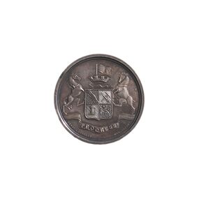
Medal - Sandhurst Industrial Exhibition Medal, Ernest A. Altmann, 1879
The Sandhurst Industrial Exhibition was held in Sandhurst at the Market Building and Corn Exchange and was opened by the Marquis of Normandy on the 17th March 1879. Modelled on a similar event held in Ballarat the previous year which was largely aimed at displaying the work of juvenile artisans, the Sandhurst Exhibition was more general in its purpose and provided more space for the general exhibition of products, natural and manufactured from the broader surrounding district. The opening event included a procession of all the friendly societies, fire brigades and other local institutions. Obverse Description; Bendigo Coat of Arms Reverse Description; (Text only) Edge Description; PlainObverse Description: Progress Ernst A Altmann Reverse Description: Sandhurst Industrial Exhibition / 1879 / Awarded to / George R Bennett / South Yarra / Inlaid Marble / Chess Tablecity of greater bendigo medals, sandhurst industrial exhibition 1879 -
 Harcourt Valley Heritage & Tourist Centre
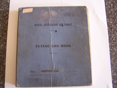
Flight Log Book, 1942
A SCION OF A PIONEERING HARCOURT FAMILY. KENNETH WARREN ENLISTED 3/1/1942. THE FLIGHT LOG REVEALS HIS SUBSEQUENT CAREER, WHICH COMMENCED WITH PILOT TRAINING AT BENALLA, VICTORIA 23/8/1942, TRANSFERED TO MALLALA SA OCT 1942 TO FEBRUARY 1943, THENCE TO CROUGHTON UK FROM 30 JUNE 1943 TO SEPTEMBER 1943 FOR FURTHER TRAINING, AT HUSBANDS BOSWORTH SEPTEMBER 1943 TO OCTOBER 1943, COMMENCED OPERATIONAL FLIGHTS OUT OF MARKET HARBOROUGH 18 OCTOBER 1943 THEN VARIOUS SQUADRONS IN BOMBING RUNS OVER EUROPE UNTIL 7TH MAY 1944 WHEN HIS LANCASTER BOMBER FAILED TO RETURN.. K R Warren was aged twenty when given command of a Lancaster bomber in the RAF. He was one of six Harcourt men who enlisted, trained and took to the air in defence of Britain during WW2BLUE CLOTH COVERED BOOK - BLACK PRINTINGROYAL AUSTRALIAN AIR FORCE -
 Harcourt Valley Heritage & Tourist Centre
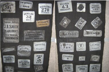
Fruit Box Stencils, 1905-1910
Tin stencils were used to brand fruit cases to indicate the source and the destination of Harcourt Fruit for sale to local, interstate and overseas markets. These stencils are typical and also indicate grade/size of fruit. These stencils were used by J. B. Smith of Harcourt and N.C. Gaasch of Harcourt. Both of these growers customarily exported their fruit to England and Germany.An aid to marketing and branding Harcourt fruit, which had been sent in wooden cases for sale. Stencils, tin with delivery and sender details. Collection also includes ink block for branding the stencil information on to boxes. -
 Harcourt Valley Heritage & Tourist Centre
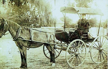
Ann Milford in Buggy, 1896
This photo dates from circa 1896. It depicts Mrs Sarah Ann Milford, then aged 65, in a buggy somewhere in Castlemaine. Mrs Milford is holding the reins in gloved hands, having driven five miles into town from her home on the Faraday Road, Harcourt. The journey would have taken about one hour. Mrs. Milford together with her farmer/orchardist husband, worked an extensive orchard/farm, Here she is depicted having delivered apples, butter and vegetables from her family orchard to Castlemaine market. Mrs Milford is wearing a strictly tailored 'must fit snug everywhere' jacket with shoulder cape, very full sleeves, closely buttoned bodice, high neckline and rather severe collar. The skirt was separate , of lined brown twill cotton, pocket at side back. A buggy rug is strapped across her knees. The buggy rug was lined with yellow and black figured damask. Despite the masculine-oriented property laws and society norms many Victorian women were active partners in their family business. The photo is a good record of the fashions, transport and capabilities of this pioneer.Sepia photograph of a woman dressed in Victorian fashion, seated in a covered four wheel buggy.The horse is equipped with light buggy harness and wearing a buggy bridle. -
 Harcourt Valley Heritage & Tourist Centre
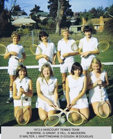
Tennis Club Photograph, Harcourt Tennis Club, 1973
Tennis was first played at Harcourt North at the "Brooks Tennis Courts" and as it increased in popularity a team commenced playing at courts at the corner of High and Market Sts Harcourt in the early 1900s. At one time it was known as the Alexander Tennis Club.New courts at the football oval in Bridge Street were eventually replaced by courts at the new oval at Binghams Road, Harcourt. The Harcourt teams play in the Castlemaine District Lawn Tennis Association competition. This team shot, chosen at random from our holdings, depicts young players of both sexes.Tennis has proven to be a great social game involving a high proportion of women and young people in the competition.Colour Photograph of the 1972/3 Harcourt tennis teamHarcourt Tennis Club -
 Wodonga & District Historical Society Inc
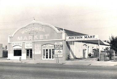
Photograph - Mann Collection Album - Wodonga Market, C. 1960s
... throughout the late 20th century. Wodonga businesses High St Wodonga ...Elaine Mann was married to David Mann, a successful Wodonga businessman and community leader who passed away in Wodonga in June 2012. David was a member of the Mann family who began their business in Wodonga in 1920. Elaine was a teacher in Wodonga for many years and an active member of the community.This photo collection is of significance as it documents how the businesses and buildings in Wodonga have evolved and contributed to community throughout the late 20th century.This building was erected in the 1890's. It was originally the premises of the Federal Coach Factory, then Buntz's Garage, and became Mylon's Garage. July 1960 saw it open as Wodonga Market. An article in Wodonga and District Express dated 1 July 1960 announced: “Wodonga’s New Market Open Today” Arcade Style Shopping "Wodonga’s new market will be open as from morning trade today. Modelled on current overseas open marketing ideas, the new business is similar to the Albury Market in David Street. The Manager (Mr. Ned Day) said yesterday that shops and stalls were sub-let to tenants for a “co-operative rent” which enabled the market to pass these advantages on to the people in lower prices. The building would lend itself to the arcade style which made attractive presentation and would also assist the customer to make quick purchases. There was over 5000 square feet of shopping space.” Businesses open that day were Gerecke’s with a display of secondhand furniture and fittings, and a poultry mart to open the following Friday. Also Webster’s Fruit and Vegetables. Mr. Ned Day advertised space for a variety of listed business types. Businesses recognised in the photo include a Butcher, Webster's Fruit & Vegies, Bill Dunstan's Boat Centre. Snack Bar/Fish & Chips/Milk Bar Auction Mart, New & Used Furniture. Poultry was also available every Friday. The building was demolished in 1963.wodonga businesses, high st wodonga, wodonga market, auction mart -
 Wodonga & District Historical Society Inc
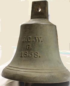
Functional object - Gordon Family Orchard Bell
The Gordons were architects and were associated with many buildings still standing in Albury and Wodonga, St Patrick's Church and the de Kerilleau Homestead among them. They established Vermont Orchard on 74 acres to the south of the Wodonga settlement. Here they grew fruit and nuts for the domestic and export market. The enterprising family also set about transforming some of the land by clearing it, creating streets and making general improvements. It was the biggest subdivision in Wodonga at the time. The 234 allotments in the Wodonga Estate were put up for sale by auction in May 1890. A total of 200 people were said to have attended. Gordon, William, Charles and Vermont streets in Wodonga are named after the family. This bell was used at the Vermont orchard to signal the beginning and end of the working day, as well as lunch breaks.The Gordon Family orchard bell is made of cast iron. It includes the inscription "J. C. W../G./1858." This is thought to represent the initials of John Gordon and sons Walter Joseph and Charles Goodwin Sylvester Gordon. There is some conjecture about this due to the date "1858". John was born in London, England in 1823 and died in 1880. Walter is generally accepted to have been born in 1857 and died 1903. In one family tree Charles is recorded as being born on 28 January 1858 but his birth was registered in 1860. The mystery of the date is therefore not fully resolved.On one side of the bell "J. C. W../G./1858."gordon family wodonga, gordon and gordon architects, vermont wodonga -
 City of Kingston
Photograph - Colour, Paul Tresize, 1998
The name Mordialloc was derived from the name Moody Yallock, which comes from the Bunurong language. The Bunurong Peoples are the Traditional Owners of this area. The name means “high water” or “high creek”. In 1839, colonial authorities declared the mouth of the creek, and an additional 830 odd acres as an Aboriginal Reserve, although this proclamation was never gazetted. The reserved land included part of the Carrum Carrum Swamp which was abundant with wild life and natural resources. Regular encroachments, including land sales which began in 1863, were made on the land until 1878 when the Reserve was declared closed, and the land was opened up to land sales. Market gardening and suburban house lots quickly began to develop, and Mordialloc became a renowned picnic and holiday site. Mordialloc Creek is a popular bay side destination for local and visitors, and is a site for boating, kayaking, fishing and swimming, along with many other activities.Colour photograph of Mordialloc Creek with boats moored on both sides of the street and Pompei's boat yard visible on the right hand side of the creek., Main Street and St Brigid's Catholic Church are visible in backgroundmordialloc, bunurong, traditional owners, suburbs, boats, fishing, waterways, hotel, church -
 City of Kingston
Photograph - Colour, Paul Tresize, 1998
The name Mordialloc was derived from the name Moody Yallock, which comes from the Bunurong language. The Bunurong Peoples are the Traditional Owners of this area. The name means “high water” or “high creek”. In 1839, colonial authorities declared the mouth of the creek, and an additional 830 odd acres as an Aboriginal Reserve, although this proclamation was never gazetted. The reserved land included part of the Carrum Carrum Swamp which was abundant with wild life and natural resources. Regular encroachments, including land sales which began in 1863, were made on the land until 1878 when the Reserve was declared closed, and the land was opened up to land sales. Market gardening and suburban house lots quickly began to develop, and Mordialloc became a renowned picnic and holiday site. Mordialloc Creek is a popular bay side destination for local and visitors, and is a site for boating, kayaking, fishing and swimming, along with many other activities.Colour photograph of Mordialloc Creek with boats moored on both sides of the street and Pompei's boat yard visible on the right hand side of the creek., Main Street and St Brigid's Catholic Church are visible in background.mordialloc, bunurong, traditional owners, boats, fishing -
 City of Kingston
Photograph - Black and white, c. 1930
... , Moorabbin railway station, St David's Anglican Church market gardens..., Moorabbin railway station, St David's Anglican Church market gardens ...During the 1930s Moorabbin was an area with open grasslands, still often used for market gardening. The development of the city (and, later, suburb) can be seen emerging from the railway station.The Nepean Highway is a major highway running through the City of Kingston. This image is one of many that depicts its importance to the local community as it undergoes many changes over time.Black and white photograph of aerial view of intersection of Nepean Highway and South Road. Moorabbin Council Chambers are situated on the corner with the library, old shire building, Moorabbin railway station, St David's Anglican Church market gardens and open paddocks in the background.White round sticker on reverse with black printed text: 143 Handwritten in red ink on reverse: 156% / k000786moorabbin, council, railway station, railway, suburbs, paddocks, nepean highway -
City of Kingston
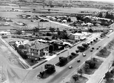
Photograph - Black and white, 27 February 1964
Cheltenham is a suburb in the City of Kingston that was originally established as a rural market gardening community. The area is bordered by Highett. The previous market gardens, farms and paddocks have gradually been sub-divided into housing and industrial estates. The Methodist Children's Home Methodist Homes for Children and St John of God Training Centre on the site of the future Southland shopping centre has not yet been demolished. The recently built Cheltenham High School is visible and the increased urbansation of the area is evident. Some farmland remains including the Le Page homestead.The developing urban area of Cheltenham within the City of Kingston. This image illustrates the mid-century urban sprawl of of Cheltenham and the subdivision of market gardens within the municipality and the changing demographic of the district as new houses are constructed and infrastructure established.Aerial photograph of the suburbs of Cheltenham and Highett within the City of Kingston. Highett Gas Works (top left); Bernard Street, Cheltenham (top right); Weatherall Road (bottom left): Elliott and Cobham Streets Cheltenham (bottom right).White handwritten: X Vic.1831 White type: MELBOURNE 1963 PROJECT RUN23 [underlined] 27-2-64 LENS 205 152-70 M/M 5.150 [arrow] White handwritten: X 166 cheltenham, highett, urbanisation -
 City of Kingston
Photograph - Black and white, c.1945
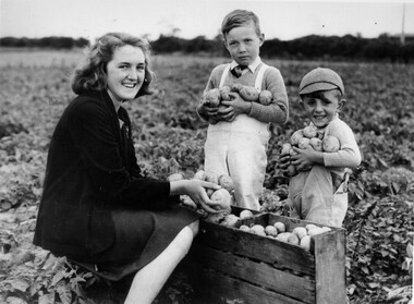
This photograph shows Gladys Marriott, aged 15, in the potato fields of her father's property in Moorabbin. Her cousin Graeme (centre) and younger brother Alfred (right) are with her. Moorabbin is a suburb in the City of Kingston that was originally established as a rural market gardening communityThe Marriott property in Moorabbin was adjacent to a secret wartime wireless receiving station established in March 1942 in Chesterville Road, Moorabbin. The station was established on requisitioned market garden properties, and soon housed WRAN (Women's Royal Australian Navy) personnel and up to 35 US Navy servicemen. The Navy personnel intercepted Japanese coded communications and then despatched these by motorbike messenger to Queens Road, St Kilda where the Directorate of Naval Communications and the code-breaking unit called FRUMEL (Fleet Radio Unit - Melbourne) were housed. The information intercepted by the wireless receiving station helped shape the Allied response to Japan's advances in the Pacific. Declassified defence records show that this unprepossessing station handled some of World War II's most sensitive secrets, however the local community were unaware of its significance. Gladys Marriott, working on her father's property, would regularly take the family's cows to graze in the fields adjoining the station with no concept of what the Navy personnel were doing. Black and white photograph of a young woman and two small boys standing around a wooden crate filled with potatoes. They each have potatoes in their hands. They are standing in a field. Handwritten in red ink: A 601 / 72% Handwritten in black ink: CHAP 6. Handwritten in black ink: GLADYS STOTT (MARIOTT) / DURING WAR YEARS / With Spybase Storymarket garden, children, farming, local production, world war ii, wireless receiving station, moorabbin -
 City of Kingston
Photograph - Black and white, c.1942
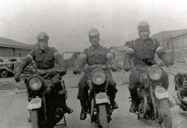
This image shows motorbike despatch riders who were tasked with transporting intercepted Japanese communications from the wartime wireless receiving station established in Chesterville Road, Moorabbin to Queens Road, St Kilda where the Directorate of Naval Communications and the code-breaking unit called FRUMEL (Fleet Radio Unit - Melbourne) were housed. The despatch riders would travel every two hours, all day and night. The wireless receiving station was established in Moorabbin because it was considered an area free of significant electrical interference and was not too far afield from the Melbourne headquarters in Queens Road. Moorabbin was originally established as a rural market gardening community.A secret wartime wireless receiving station was established in March 1942 in Chesterville Road, Moorabbin. The station was established on requisitioned market garden properties, and soon housed WRAN (Women's Royal Australian Navy) personnel and up to 35 US Navy servicemen. The Navy personnel intercepted Japanese coded communications and then despatched these by motorbike riders to Queens Road, St Kilda where the Directorate of Naval Communications and the code-breaking unit called FRUMEL (Fleet Radio Unit - Melbourne) were housed. The information intercepted by the wireless receiving station helped shape the Allied response to Japan's advances in the Pacific. Declassified defence records show that this unprepossessing station handled some of World War II's most sensitive secrets, and the despatch riders were a familiar sight in the Moorabbin area, though few were aware of their purpose. Black and white image of three men in uniform sitting astride three motorcycles in front of cars and buildings. The rider on the right is Jack Barker a local resident. Handwritten in red ink: A 602 / 90% Handwritten in blue ink: SW / 950301111 Handwritten in grey pencil: A 34 CHAP 6 / Spy basemoorabbin, despatch riders, wireless receiving station, world war ii, frumel (fleet radio unit - melbourne) -
Port Melbourne Historical & Preservation Society
Photograph, Aerial Survey of Port Melbourne; December 1945, 2105
Seventeen (17) individual photos were joined together by John KIRBY to make a compsite image.Aerial Survey of Port Melbourne; December 1945 Large photograph mounted on foam board. Shows aerial view of Port Melbourne showing its extent from the Bay. Panel on right hand side has key to numbered areas on map . PMHPS logo on top left cornereclipse picture theatre, brookes lemos ltd, built environment, local government, natural environment, built environment - industrial, religion - roman catholic church (st josephs), gmh, general motors-holden, rotten row, sport - trotting, j kitchen & sons pty ltd, australian wool board, government aircraft factory, gaf, commonwealth aircraft corporation, cac, north port oval, fire and fire services, market reserve, religion - presbyterian church, leading lights, foresters arms hotel, commonwealth government engine works, st josephs catholic primary school, mission to seamen, centenary bridge, naval drill hall, mail exchange, gasworks, piers and wharves - town pier, robert harper & co ltd, ran - royal australian navy, hmas lonsdale, port melbourne yacht club, pmyc -
 Port Melbourne Historical & Preservation Society
Photograph - Market shop demolition
Market buildings established 1885. Demolition retained streetscape but allowed new businesses .Colour photo showing Market shop demolition in Bay St 1989. Old frontage retained. Nott St homes and Council flats visible in backgroundbuilt environment - demolition, built environment - commercial, built environment - civic -
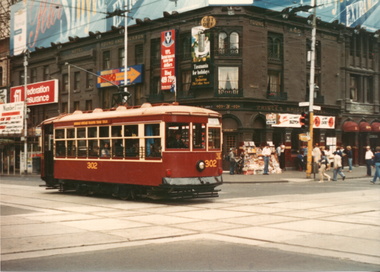 Ballarat Tramway Museum
Photograph - Bendigo - Adelaide 302 in Melbourne, 25/1/1982
Set of two colour prints of ex Adelaide Birney No. 302 (former Bendigo tram 29) in Melbourne for the 1982 Australia Day Transport Pagent. The first photo is at Swanston and Flinders St with Young and Jackson Hotel in the background and the second at Flinders and Market Streets with a Hitachi Silver train on the railway viaduct. Not known who took the photographs. See Feb. 1982 issue of Electric Traction for a note regarding this tram in Melbourne for the Pagent.Yields information about Bendigo No. 29 as Adelaide 302 in Melbourne Set of two Colour prints - on plain papertramcars, tram 29, bendigo, birney tramcars, flinders st, swanston st, pageant -
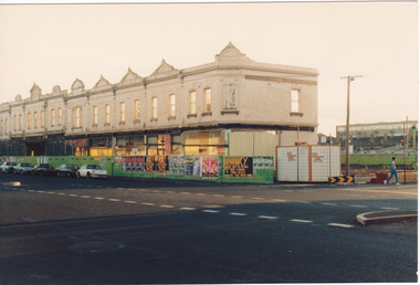
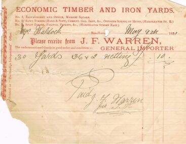 Bendigo Historical Society Inc.
Document - J.F.WARREN INVOICE, 9/05/1891
John Frederick Warren was born in England in 1834. After coming to Australia, he married Rebecca Baird in 1868. He initially tried his hand at mining before establishing his timber and iron works. He retired in 1902 and lived at "Bowden", Barnard Street, until his death 21/10/1912. Following his retirement, the business was continued by his son John Frederick Warren jnr (b. 1879).J.F.Warren Invoice: Cream paper with red print. Torn left bottom half. Economic Timber and Iron yards. NO. 1 Ironmongery and Office, Market Square. No 2 Sawn Timber (Hard & Soft), Cement. Gal. Iron. &c. Opposite School of Mines, (Hargreaves St. E.) No. 3 Split Timber, Palings, Pickets, &c. (Hargreaves Street East). To: Mrs Waldock. Sandhurst May 9th 1891. Please receive from J.F Warren, The undermentioned Goods in good order and condition:- General Importer. For 30 Yards 36 x 2 netting £10. Paid J.F.Warren per S. H. Box 625.Printed at 'The Bendigo Independent' Office.business, retail, house furnishings, j.f. warren. mrs waldock. -
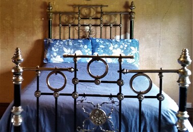 Hymettus Cottage & Garden Ballarat
Furniture - Bed, Iron Bedstead
19th century iron and nickel plated brass bed formerly in the Catholic Bishop's Palace Ballarat. Originally purchased for the palace in the 1870s and bought at auction to replace similar bedstead that was broken at Hymettus.A recorded piece with history of only two owners, marketed from Ballarat manufacturer and retailer Tunbridge & Sons in the late 19th century.Nickel plated iron & brass three quarter bed. Base stretcher stencil label of Tunbridge & Sons manufacturer Ballarat.On timber matress base/frame stamped Tunbridge & Sons Ballarat.bishops' palace, ballarat, bed, iron furniture, -
 Hymettus Cottage & Garden Ballarat
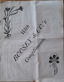
Work on paper - pamphlet, Boosey & Co's Compliments
non-fictionmusic, musical instruments, brass bands, -
 Clunes Museum
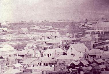
Photograph
BLOWN UP PHOTO OF VIEW OVER LOOKING FRASER ST. FROM "THE ROCKS". NOTE 2 CHURCHES - ONE C OF E, LATER MOVED TO PRESENT SITE, NEXT TO BLUE STONE ST. PAUL'S. CLUB HOTEL ON LEFT. "METHODIST CHURCH WITHOUT SPIRE AND MARKET NEXT ON PRESENT POLICE STATION PADDOCK OPPOSITE THE METHODIST CHURCH (THEN WESLEYAN) IS THE OLD CEMETERY AND THERE ARE WHITE FORMS LIKE TOMBSTONES SHOWING.BLACK AND WHITE PHOTOGRAPH OF VERY EARLY CLUNES - BUILDINGS, CHURCHES, HOUSESPRIMITIVE METHODIST CHURCH IN HILL ST.local history, photography, photographs, clunes township -
 Eltham District Historical Society Inc
Photograph - Digital Photograph, Marguerite Marshall, One Tree Hill Mine, Smiths Gully, 8 June 2006
Gold was discovered on One Tree Hill in 1854. The site has been worked intermittently until fairly recent times. Published: Nillumbik Now and Then / Marguerite Marshall 2008; photographs Alan King with Marguerite Marshall.; p53 Though still a working mine, One Tree Hill Mine at Smiths Gully, now stands in a tranquil reserve surrounded by bush and native animals - in contrast to its heyday. In the mid 19th century, when the mine was part of the Caledonia Goldfields, hundreds of men in search of their fortune worked the alluvial gold in the Yarra River, its tributaries and the reefs that made up the goldfields. Miner Stan Bone, assisted by Wilfred Haywood, is the last of the independent gold miners in the area and still uses the quartz crushing battery as miners did when gold was first discovered in the area in 1851.1 Stan, who is the last of six generations of miners in his family, was aged 17 when he began mining on his father Alex’ mine, The Golden Crown in Yarrambat. These days, after blasting the gold-bearing rock in Mystery Reef, one of the four reefs at One Tree Hill, Stan transports it around five kilometres by tip truck to the Black Cameron Mine for crushing. There he uses water from the waterlogged mine, (which still contains gold), as the Happy Valley Creek at One Tree Hill is usually dry.2 The One Tree Hill Mine has been worked for close to a century since it opened around the late 1850s.3 The Swedish Reef was its most productive reef and one of the largest in the area. Around 1859, extractions included 204 ounces (5.8kg) of gold, won from 57 pounds (26kg) of stone.4 Then during World War Two, Stan’s uncle, Bill Wallace, and Alex Bone, closed the mine. In 1973, Stan, with his Uncle Bill, reopened the Black Cameron Mine and worked there until 1988. Stan resumed mining One Tree Hill in 1998. As late as the 1920s gold was picked up by chance! When crossing a gully on his way to vote at the St Andrews Primary School, Bill Joyce picked up some quartz containing gold. This site was to become the Black Cameron Mine. The Caledonia Diggings, named after Scotland’s ancient name by local Scots, began around Market Square (now Smiths Gully) and included Queenstown (St Andrews), Kingstown (Panton Hill) and Diamond Creek. There were also poorer bearing fields in Kangaroo Ground and Swipers Gully (now Research). * None of these compared in riches to the Ballarat and Bendigo fields5, but the Caledonia Diggings continued intermittently for close to 100 years. Gold was discovered in Victoria following a bid to stem the disappearance of much needed workmen to the New South Wales diggings. Several businessmen offered a reward of £200, for the discovery of gold within 200 miles (322 km) of Melbourne. Late in June 1851, gold was first discovered at Andersons Creek, Warrandyte. Then in 1854, George Boston and two other men discovered gold at Smiths Gully. Gold transformed the quiet districts, with a constant flow of families and vehicles on the dirt tracks en route to the Caledonia Diggings. Three thousand people worked the gullies in Market Square, including about 1000 Chinese miners. The square established its own police, mining warden, gold battery, school, shops and cemetery and grog flowed. Market Square flourished until the middle 1860s. Bullocks transported quartz from the Caledonia Goldfields to the crushing machinery at the Queenstown/St Andrews Battery, near Smiths Gully Cemetery. It was destroyed by bushfire in 1962. By the late 1850s, most early alluvial fields were in decline, but minor rushes continued until around 1900 and some until the early 1940s. Some miners did well, although most earned little from their hard labour in the harsh and primitive conditions.6 But according to historian, Mick Woiwod, the gold fields helped to democratise society, as individuals from all walks of life were forced to share experiences, and the ability to succeed, depended less on inherited wealth or social rank.This collection of almost 130 photos about places and people within the Shire of Nillumbik, an urban and rural municipality in Melbourne's north, contributes to an understanding of the history of the Shire. Published in 2008 immediately prior to the Black Saturday bushfires of February 7, 2009, it documents sites that were impacted, and in some cases destroyed by the fires. It includes photographs taken especially for the publication, creating a unique time capsule representing the Shire in the early 21st century. It remains the most recent comprehenesive publication devoted to the Shire's history connecting local residents to the past. nillumbik now and then (marshall-king) collection, gold mining, one tree hill mine, smiths gully -
 Eltham District Historical Society Inc
Photograph - Digital Photograph, Alan King, Queenstown Cemetery, Smiths Gully Road, St Andrews, 28 December 2007
The discovery of gold in Smyth's Creek in 1854 and subsequent gold rush to the Caledonia diggings led to the establishment of Queenstown (present day St Andrews). The first recorded burial was July 31st, 1861 and it was officially declared a Cemetery Reserve in 1866. Many graves are unmarked and unrecorded including many Chinese and other itinerant miners. The cemetery was closed for new burials in 1851. The last recorded burial was in 1981 in an existing family grave. In Loving memory of David Band Died 30th Decr. 1862, aged 51 years. John Cork Knell Died 11th April 1867, aged 42 years. Eliza Smith Died 20th Jany. 1874, aged 3 1/2 years. William Band Died 20th Feby. 1883, aged 51 years. Published: Nillumbik Now and Then / Marguerite Marshall 2008; photographs Alan King with Marguerite Marshall.; p73 The discovery of gold at Smyth’s Creek* in 1854 brought 3000 people to the area in search of their fortunes.1 However in the harsh conditions many miners and their families died young, and were buried in unmarked graves. Their stories died with them but by 1861, the first burial was recorded at the Queenstown Cemetery – that of William Dalrymple aged 65 – although the cemetery was only officially declared a reserve in 1866. Even before this in 1856, a double burial had been recorded for the twin baby daughters of George Harrison at Market Square, the miners’ settlement – presumably where the cemetery is today. In 1951 the Queenstown Cemetery at 70 Smiths Gully Road, Smiths Gully, closed for burials. However the last burial in a family plot, that of Grace Evelyn Smith, occurred in 1981. Today only 55 headstones remain, but more than 380 burials are recorded. Remnant bushland dominates the cemetery where many graves are merely mounds and others have been damaged by vandalism and the neglect of time. Bushfire in 1962 destroyed the picket fencing, grave markers and cypress boundary planted in the early 1900s. The box/stringybark woodland in the 1.7 hectare Cemetery Reserve is regrowth from then and the indigenous and heritage vegetation is protected. Thanks to the volunteer Cemetery Trust and Friends & Relations of Queenstown Cemetery, the cemetery is maintained, stories recorded and the burial index corrected and expanded.2 Close by the cemetery on the site of today’s Peter Franke Picnic and Nature Reserve stood Market Square, the Caledonia Diggings village of tents and stores, the forerunner of Queenstown, now St Andrews. Many of the Caledonia Diggings miners were Chinese, many of whom, with itinerant prospectors, were buried in unmarked graves. Histories are being recorded of other immigrants, mainly English and German, who settled after the gold rush, some of whose descendants fought and died in the two world wars. Names on many headstones are also recorded on the district’s roads, reserves and war memorials such as Motschall, Joyce, Howard and Coutie. The oldest surviving tombstone is that of Scot, David Band who died in 1862 at 51 years. His oldest daughter Elizabeth, with husband John Knell, owned the Queenstown Hotel and the post office. Child-rearing in a colonial gold town was often tragically difficult, as demonstrated in the first 20 years, when 41% of the 34 burials recorded were children. Settlers endured harsh conditions graphically illustrated with the deaths of Annie Joyce at 30 years and of her family. Annie was married to gold miner Walter Joyce. Their third child Walter, born in 1886, died in March 1887. Eight months later Annie died of breast cancer. Walter died in 1909, aged 53, of miner’s phthisic caused by stone dust destroying his lungs. It was so hard to make a living that burials were usually held from 2.30 pm to allow mourners to work a day before paying their last respects.3 Most burials before 1890 were recorded as Anglicans, as the only church on the Caledonia Diggings was the Church of St Andrew, until 1897, when the Primitive Methodist Church came to Panton Hill. Generally miners came to better themselves, but some, like Grace Hopkinson (nee Milward), born in England in 1828, came from a well-off and educated family. According to family legend Grace emigrated with husband William, to live in a tent, but had kept her personally embossed sterling silver cutlery service. Amid the tough environment were some successes like that reported in The Evelyn Observer April/May 1901 of miner William Hopkinson who was buried at the cemetery in 1912 aged 81. The Observer stated that Hopkinson ‘recently dropped across another find in his claim at One Tree Hill’. The lump of gold found this time weighed more than half a kilo. Mr Hopkinson referred to it as ‘another little speck’. *Today’s Smiths GullyThis collection of almost 130 photos about places and people within the Shire of Nillumbik, an urban and rural municipality in Melbourne's north, contributes to an understanding of the history of the Shire. Published in 2008 immediately prior to the Black Saturday bushfires of February 7, 2009, it documents sites that were impacted, and in some cases destroyed by the fires. It includes photographs taken especially for the publication, creating a unique time capsule representing the Shire in the early 21st century. It remains the most recent comprehenesive publication devoted to the Shire's history connecting local residents to the past. nillumbik now and then (marshall-king) collection, david band, eliza smith, gravestones, john cork knell, queenstown cemetery, smiths gully road, st andrews, william band -
 Eltham District Historical Society Inc
Photograph - Digital Photograph, Alan King, Eltham Living and Learning Centre, 26 January 2008
In 1857, tanner John Pearson purchased three and a half acres of land in Little Eltham, at the western end of Pitt Street, with a 70-foot frontage to Maria Street (Main Road) and stretching down to the Diamond Creek for £100. He contracted Benjamin Oliver Wallis to build house for him. Wallis, a mason by trade who originated from the Cornish village of Newlyn, migrated to Melbourne in 1853 and was shortly engaged by Richard Warren to build the Eltham Hotel, which opened in 1854. When Warren fell into financial difficulty in 1858, Wallis purchased the hotel. That same year, Pearson constructed a tannery below the house with access to the water in the Diamond Creek. When Pearson became bankrupt in 1867, Wallis similarly acquired the house from Pearson’s creditors in 1868 and lived there until his death in 1896. For some of this time the house was in the name of Wallis’s son Richard but following his death in 1888, ownership reverted to his father. It was purchased by retired teacher Richard Gilsenen in 1899. Gilsenen was made acting head teacher at the Eltham State School in 1906 following the sudden death of head teacher John Brown. In the 1950s the house was bought by retired engineer Dr Alfred Fitzpatrick and his wife Claire who made various modifications to house goats and poultry as well as structural modifications to the house. In the early 1970s, Eltham Shire Councillors Frank Maas and Don Maling proposed an extended communities’ activities program be set up and the Commonwealth Grants Commission was approached for financial assistance. In 1974 a $50,000 Commonwealth Grant was received by the Shire Council to acquire the Fitzpatrick property as part of the planning to establish an extended communities’ activities program. The Fitzpatricks moved next door and Claire taught at the new Living and Learning Centre, which began in 1975, one of the first community education centres in Victoria. Covered under Heritage Overlay, Nillumbik Planning Scheme. Published: Nillumbik Now and Then / Marguerite Marshall 2008; photographs Alan King with Marguerite Marshall.; p59 It’s a centre for sharing knowledge and friendship and it stands on the former hub of Eltham’s original township near Pitt Street. The Eltham Living and Learning Centre, with around 2000 participants a year, began in 1975 as one of the first Community Education Centres in Victoria. Classes ranging from macramé to wine making to environmental living have enriched the lives of thousands of people through the generosity of tutors sharing their skills free of charge. The centre’s heart is the brick cottage, built in 1858 by tanner John Pearson. He bought the three and a half acre (1.4ha) allotment fronting Maria Street (now Main Road) and stretching down to the Diamond Creek. The allotment formed part of a 316 acre (127.8ha) subdivision, owned by Josiah Holloway, called Little Eltham, north of the original Eltham Reserve.1 The allotment then passed through the hands of several speculators before it was sold to Pearson for £100 in 1857. Mr Pearson’s children attended the Eltham Primary School from 1864 to 1867. But creditors took possession of the property when his tannery folded in 1867. It was then sold to publican Benjamin Wallis, who owned the Eltham Hotel at the corner of Pitt Street and Main Road. In 1899 the property was bought by Richard Gilsenan, who became acting head teacher of the Eltham Primary State School in 1906. In the 1950s, retired engineer Dr Alfred Fitzpatrick and his wife Claire bought the property, and made structural changes. Claire, a journalist and community campaigner, modified and built pens for goats and poultry, a stable, a garage and planted fruit trees and a vegetable garden. In the early 1970s a young woman called Carina Hack approached Gwen Wesson at the Diamond Valley Learning Centre (Victoria’s first Community Education Centre) about starting a community centre. Following Wesson’s suggestion, Hack spoke to Shire President Alistair Knox ‘one bleak rainy afternoon, sipping hot drinks and discussing life’.2 Eltham Shire Councillors Frank Maas and Don Maling proposed a community activities program and the council received a $50,000 Commonwealth Government Grant for this venture.3 The Fitzpatricks sold their property to the council and moved next door and Claire taught at the new centre, which Hack named. Eltham obviously wanted such a centre as Hack recalls. ‘During the next two months we had about 50 volunteers working day, night and weekends, scrubbing down, plastering and painting walls, replacing floors, repairing fences, recycling furniture, sewing curtains and cushions, donating furniture, toys, equipment, clean-ing and gardening…’4 The first enrolment day saw a queue stretching up the driveway nearly to the gate and the first sessions attracted 270 people a week. Soon the outbuildings were converted into pottery studios and a large workshop. From 1979 the Eltham Art and Craft Market was held in the centre’s grounds and the Friends of the Centre ran it from 1980. A former program coordinator, Margaret Johnson, remembers enrolment day in the late 1970s and 1980s, when hundreds of people would queue – and some even camped overnight! Overnighters were greeted in the morning with fresh tea and toast. Another tradition was The Enrolment Day Cake with Recipe, given to volunteers. ‘One happy Enrolment Day fell on February 14 and let’s just say that St Valentine found some willing participants, paying $2 for a kiss.’5 Meanwhile the participants’ children could play at the Council Eltham Lower Park house in Hohnes Road, later in Susan Street. But the centre has had difficulties too. In 1990 a fire destroyed the stable and the police suspected arson. However the pavilion was built in its place.This collection of almost 130 photos about places and people within the Shire of Nillumbik, an urban and rural municipality in Melbourne's north, contributes to an understanding of the history of the Shire. Published in 2008 immediately prior to the Black Saturday bushfires of February 7, 2009, it documents sites that were impacted, and in some cases destroyed by the fires. It includes photographs taken especially for the publication, creating a unique time capsule representing the Shire in the early 21st century. It remains the most recent comprehenesive publication devoted to the Shire's history connecting local residents to the past. nillumbik now and then (marshall-king) collection, benjamin oliver wallis, claire fitzpatrick, don maling, dr alfred fitzpatrick, eltham living and learning centre, frank maas, john pearson, richard gilsenen, tannery -
 Ballarat Tramway Museum
Negative - Tram 40 - Moorabool & Malop Streets, Laurie Gallop, early 1956
Photo shows Geelong 40 on its way to North Geelong, turning from Moorabool St into Malop St. In the background are now the National Mutual and Market Square buildings. One of a set of photos was taken between 15/2/1956 and 3/3/1956 when services operated only between Belmont and North before the final closure of the Belmont route on 25/31956 and that bogie tram 31 is not shown on the board, having gone to Ballarat on 15/2/1956 - see item 5554. See item 8213 for an article on the Geelong system by Keith Kings. Yields information about the Geelong operations toward the closure of the tram system.Black and white Negative - 120 sizetramways, geelong, moorabool st, malop st, tram 40