Showing 2390 items
matching surround
-
 Greensborough Historical Society
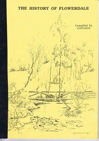
Book, Gaye Hine, The History of Flowerdale, complied by Gaye Hine, 1991
A history of Flowerdale and surrounds by the students at Flowerdale Primary School and members of the community for the school centenary in 1991.60 p., black and white print and photographsflowerdale, flowerdale primary school -
 Tatura Irrigation & Wartime Camps Museum
Photograph, 1955 flooding, 1955
Sacred Heart Primary School, Tatura, surrounded by flood waters, 1955. School later demolished.Black and white photograph of flooding, Sacred Heart Primary School, Tatura, 1955.on back: Sacred Heart Primary School, Tatura. Flood. 1955. -
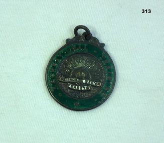
 Vision Australia
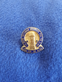
Badge - Object, Light for the Blind badge, 194
A gold embossed lighthouse is surrounded by the words 'The Royal Victorian Institute for the Blind' and at the base 'Light for the Blind'. 1 gold and blue badgebadges, royal victorian institute for the blind -
 Bendigo Historical Society Inc.
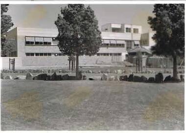
Photograph - S.E.C. VICTORIA, 1941
Black and White Photo of the new S.E.C. Victoria Building, Back View. Foreground lawn area surrounded by rock edging. Two established trees along rock edging. Roadway running left to right. Another lawn area with established shrub in protective surround, and two more smaller shrubs in similar protection,organization, public utility, electricity company, s.e.c. victoria building, sec victoria building -
 Bayside Gallery - Bayside City Council Art & Heritage Collection
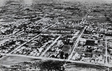
Photograph, Sandringham, 1922
sandringham, aerial, victoria, suburbs, photograph, airspy, beach street, bridge street, crisp street, seaview, hampton reserve, hampton, trevor barker beach oval -
Clunes Museum
Financial record - RECEIPT BOOK, VICTUALLER'S LICENCE
RECEIPT BOOKS, BLUE CARDBOARD COVER WITH LINEN SPINE. VICTUALLERS LICENCE 25 POUNDS. .1 Licence Numbers 4541 - 4550 dated 31/12/1890 - 24/12/1892 issued to: 4541 - 2 McCartney James, Club Hotel Fraser St Clunes 4543 Heffernan , James The Ristori Commercial Hotel, Allendale 4544 Gelbert Fred The Town Hall Hotel, 4545 Cocking Wm The Telegraph Hotel, Clunes 4546 Murray, David The Speculation Hotel, Clunes 4547 Rintel Janne The Club Hotel, Clunes 4548 Cocking Wm The Telegraph Hotel Clunes 4549 Heffernan, James The Ristori Commercial Hotel, Allendale 4550 Malley Wm The Club Hotel Clunes .2 Licence Numbers 4521 - 4530 dated 24/12/1886 to 27/12/1888 4521 Cocking William Telegraph Hotel Clunes 4522 Gelbert, Frank Town Hall Hotel, Clunes 4523 Bassett Christopher Nags Head Hotel, Clunes 4524 Burns Wm Burt Club Hotel, Clunes 4525 Cocking Wm Telegraph Hotel Clunes 4526 Gilbert Frederick Town Hall Hotel, Clunes 4527 Burns Wm Burt Club Hotel Clunes 4528 Bassett, Christopher Nags Head Hotel, Clunes 4529 Gilbert Frederick Town Hall Hotel, Clunes 4530 Cocking Wm Telegraph Hotel, Clunes .3 Licence Numbers 4531 - 4540 dated 1/1/1889 - 1/1/1891 4531 Wilson Geo. Sutherland Club Hotel Clunes 4532 Gilbert Frederick Town Hall Hotel, Clunes 4533 Heffernan James Ristori Commercial Hotel Allendale 4534 Cocking Wm Telegraph Hotel Clunes 4535 Murray David Speculation Hotel, Allendale 4536 McCartney James Club Hotel, Clunes 4537 Heffernan James Ristorii Commercial Hotel, Allendale 4538 Cocking, Wm Telegraph Hotel, Clunes 4539 Gilbert Fred. Town Hall Hotel Clunes 4540 Murray David Speculation Hotel, Allendale.1 SOFT COVER BOOK IN BLUE CONTAINS CONTAINS RECEIPTS OF VICTUALLER'S LICENCES 1890 - 1892 FOR CLUNES AND SURROUNDS HOTELS SERIES 4541 - 4550 INCLUSIVE .2 SOFT COVER BOOK IN BLUE CONTAINS CONTAINS RECEIPTS OF VICTUALLER'S LICENCES 1886 - 1888 FOR CLUNES AND SURROUNDS HOTELS SERIES 4521 - 4530 INCLUSIVE .3 SOFT COVER BOOK IN BLUE CONTAINS CONTAINS RECEIPTS OF VICTUALLER'S LICENCES 1888 - 1890 FOR CLUNES AND SURROUNDS HOTELS SERIES 4531 - 4540 INCLUSIVE .4 SOFT COVER BOOK IN BLUE CONTAINS CONTAINS RECEIPTS OF VICTUALLER'S LICENCES 1887 - 1892 FOR CLUNES AND SURROUNDS HOTELS SERIES 1 - 50 INCLUSIVE .5 SOFT COVER BOOK IN BLUE CONTAINS CONTAINS RECEIPTS OF VICTUALLER'S LICENCES 1888 - 1890 FOR CLUNES AND SURROUNDS HOTELS SERIES 1 - 50 INCLUSIVE .6 SOFT COVER BOOK IN BLUE CONTAINS CONTAINS RECEIPTS OF VICTUALLER'S LICENCES 1890 - 1891 FOR CLUNES AND SURROUNDS HOTELS SERIES 1- 50 INCLUSIVE .7 SOFT COVER BOOK IN BLUE CONTAINS CONTAINS RECEIPTS OF VICTUALLER'S LICENCES 1890 - 1892 FOR CLUNES AND SURROUNDS HOTELS SERIES 1 - 25 INCLUSIVE .8 SOFT COVER BOOK IN BLUE CONTAINS CONTAINS RECEIPTS OF VICTUALLER'S LICENCES 1891 - 1892 FOR CLUNES AND SURROUNDS HOTELS SERIES 1 - 25 INCLUSIVE .9 SOFT COVER BOOK IN BLUE CONTAINS CONTAINS RECEIPTS OF VICTUALLER'S LICENCES 1892 - 1893 FOR CLUNES AND SURROUNDS HOTELS SERIES 1 - 25 INCLUSIVE .10 SOFT COVER BOOK IN BLUE CONTAINS CONTAINS RECEIPTS OF VICTUALLER'S LICENCES 1893 - 1893 FOR CLUNES AND SURROUNDS HOTELS SERIES 1 - 25 INCLUSIVE .11 UNBOUND 15 CERTIFICATES DATED 1889 "CERTIFICATE TO AUTHORIZE THE ISSUE OF A VICTUALLER'S LICENCE" .12 UNBOUND 32 CERTIFICATES DATED 1887 "CERTIFICATE TO AUTHORIZE THE ISSUE OF A VICTUALLER'S LICENCE" .13 UNBOUND 26 CERTIFICATES DATED 1889 "CERTIFICATE TO AUTHORIZE THE ISSUE OF A VICTUALLER'S LICENCE" LABEL ON FRONT COVER: .1.2.3 VICTUALLER'S LICENCE 25 POUNDS, INITALIALED RG 5/8/1886 .4 VICTUALLER'S LICENCE 15 POUNDS .5 VICTUALLER'S LICENCE 15 POUNDS BOOK 228 .6 VICTUALLER'S LICENCE 15 POUNDS BOOK 263 ORANGE CRAYON HANDWRITING ON FRONT COVER "EXHAUSTED AFTER AUDIT 7-12-91" .7 VICTUALLER'S LICENCE 15 OUNDS BOOK 350 .8 VICTUALLER'S LICENCE 15 POUNDS BOOK 344 ORANGE CRAYON HANDWRITING ON FRONT COVER "EXHAUSTED AFTER AUDIT 7-12-91" .9 VICTUALLER'S LICENCE 15 POUNDS BOOK 398 .10 VICTUALLER'S LICENCE 15 POUNDS BOOK 399 (LABEL TORN IN HALF) RED INK HANDWRITING ON FRONT COVER "NO.1 EXHAUSTED AFTER AUDIT 24-8-93" local history, book, receipts, clunes hotels -
 Marysville & District Historical Society
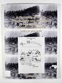
Book, A Chronicle of Life in Woods Point and Surrounds As seen Through "The Mountaineer" 1985 to present-Volume 1, 1989
A history of Woods Point and its surrounds as seen through 'The Mountaineer', a local paper published in Woods PointPaperback. Front cover has 3 of the same black and white photograph of old Woods Point. There is also a photograph of a Christmas themed front cover of The Mountaineer from December 1991. Back cover has 2 of the same photograph. Photograph is of a family standing next to a car that is parked outside the Wood's Point Hotel. In the background can be seen a shop on the left hand side of the road.Stamp of Marysville & District / Historical Society Inc / P.O. Box 22 / Marysville 3779woods point, the mountaineer, north east victoria, australia, history -
Tatura Irrigation & Wartime Camps Museum
Photograph - copy, Dhurringile Mansion Stables, 1977
Copy of original. Photograph, one of many taken by J. Lowry, of managers residence and surrounds, Dhurringile Mansion.Copy of Black and white photograph of Dhurringile Mansion stable and office block.Dhurringile Mansion stables and office block, courtyard showing butchers block and dome of underground tank. Nth wing residence of Jack and Knowla Lowry 1938-1977.dhurringile mansion stables, dhurringile mansion butchers block, dhurringile mansion, knowla lowry, jack lowry -
Tatura Irrigation & Wartime Camps Museum
Photograph - copy, Dhurringile Mansion Stables North Wing, 1977
Copy of original photograph, one many taken by J. Lowry of managers residence and surrounds, Dhurringile MansionBlack and white photograph of Dhurringile Mansion stables north wingWest view of Dhurringile Mansion stables - north wing. The residence of Mr and Mrs J. Lowry between 1938 - 1977jack lowry, dhurringile mansion managers residence -
Tatura Irrigation & Wartime Camps Museum
Photograph - copy, Dhurringile Mansion Stables, 1977
Copy of original photograph, one many taken by J. Lowry of managers residence and surrounds, Dhurringile MansionBlack and white photograph of Dhurringile Mansion stables north wingWest view of Dhurringile Mansion stables. The residence of Mr and Mrs J. Lowry between 1938 - 1977jack lowry, dhurringile mansion managers residence -
 Stawell Historical Society Inc
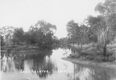
Photograph, Lake Reserve in Stawell
Lake Reserve Stawell. View of lake surrounded by trees. Now called The Grampian Gate Caravan Park.Black and white photograph of lake with trees around.Lake Reserve. Stawell. stawell -
 Lakes Entrance Historical Society
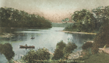
Postcard - Lake Tyers, Toorloo Bay Lake Tyers Victoria, 1905c
showing two rowing boats on calm arm of lake surrounded by thick timber Lake Tyers VictoriaTinted postcard of Toorloo Bay Lake Tyers VictoriaToorloo Bay Lake Tyers Gippsland Victoriabusinesses, hotels -
 Narre Warren and District Family History Group
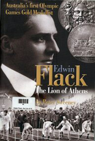
Book, Peter Sweeney, Edwin Flack - The Lion of Athens, 2004
Australia's first Olympic gold medalist. Edwin Flack's life in Berwick, his career and his travels288 p. : ill., ports. ; 24 cm. non-fictionAustralia's first Olympic gold medalist. Edwin Flack's life in Berwick, his career and his travelsathens olympic games 1896, athletics, burnbank, friesian stud, berwick (vic.) -
 Orbost & District Historical Society
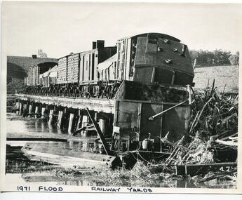
black and white photograph, February 1971
The 1971 flood was the the worst flood on record. At Jarrahmond it was at least 11 metres and up to one and a half kilometres wide on the flats causing enormous damage to the flood plain. Records say that "The brown floodwater stain in Bass Strait could be seen from passing airliners." Considerable damage was done to railway infrastructure, roads and farms. More information from the APRIL, 2008 newsletter by John Phillips. (see orbosthistory.com.au) The railway line was destroyed and was not expected to be opened for a fortnight. Orbost was cut off by 50 square miles of Snowy River floodwater. This train was being shunted across the viaduct when waters smashed through washing away several trucks sending the crew running for their lives.This is pictorial evidence of a significant local event. It is connected to the history of the railway in East Gippsland.A large black / white photograph of flooded railway yards with a train engine stranded on a small section of track surrounded by water and debris.on front - "1971 Flood, Railway Yards"floods-1971-orbost orbost-railway natural-disasters-orbost -
 Orbost & District Historical Society
black and white photograph, 1918
Tonghi Creek is 66km north - west of Orbost. Prior to the sealing of the Princes Highway west of Orbost, the road surface was anything but good, even by C1917 when cars started to use the road. From Orbost the old road via Marlo to Sydenham was abandoned for the new location which traversed more rugged country via Cabbage Tree, Bell Bird and Club Terrace to Cann River, and the reason for this diversion was on account of settlements being established at Murrungowar and Club Terrace, at which latter place there was a temporary rush to obtain gold. This road was constructed by the Public Works department and a maximum grade of 1 in 19 was adopted, and as speed was not to be catered for the grade followed in and out round the spurs and gullies, resulting in a maze of turns and twists which required a good deal of skill on the part of the horse driver to negotiate." - Bairnsdale Advertiser, Friday, May 2, 1947. (More information from Newsletter February 2010)This item is a pictorial record of roads in the early 20th century in East Gippsland.A large black / white photograph of a bridge over a small creek, surrounded by bush. The photograph is mounted on a thick cream coloured card.on back - "Bridge at Tonghi Creek 1918"tonghi-creek-bridge country-roads-east-gippsland -
 Flagstaff Hill Maritime Museum and Village
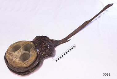
Functional object - Deadeye, Russell & Co, Circa 1886
This deadeye was amongst artefacts recovered from the wreck of the Falls of Halladale. It would have been used on the ship to attach, hold and run ropes for the ship’s rigging. The Falls of Halladale was an iron-hulled, four-masted barque, used as a bulk carrier of general cargo. She left New York in August 1908 bound for Melbourne and Sydney. In her hold was general cargo consisting of roofing tiles, barb wire, stoves, oil, and benzene as well as many other manufactured items. After three months at sea and close to her destination, a navigational error caused the Falls of Halladale to be wrecked on a reef off the Peterborough headland on the 15th of November, 1908. The captain and 29 crew members survived, but her cargo was largely lost, despite two salvage attempts in 1908-09 and 1910. The Court of Marine Inquiry in Melbourne ruled that the foundering of the ship was entirely due to Captain David Wood Thomson's navigational error, not too technical failure of the Clyde-built ship. The Falls of Halladale was built in1886 by Russell & Co., at Greenock shipyards on the River Clyde, Scotland for Wright, Breakenridge & Co of Glasgow. She was one of several designs of Falls Line of ships named after waterfalls in Scotland. The company had been founded between 1870- 1873 as a partnership between Joseph Russell, Anderson Rodger, and William Todd Lithgow. During the period 1882-92 Russell & Co. standardised designs, which sped up their building process so much that they were able to build 271 ships during that time. The Falls of Halladale had a sturdy construction built to carry maximum cargo and was able to maintain full sail in heavy gales, one of the last of the 'windjammers' that sailed the Trade Route. She and her sister ship, the Falls of Garry, were the first ships in the world to include fore and aft lifting bridges. Previous to this, heavily loaded vessels could have heavy seas break along the full length of the deck, causing serious injury or even death to those on deck. The new, raised catwalk-type decking allowed the crew to move above the deck in stormy conditions. The Falls of Halladale shipwreck is listed on the Victorian Heritage (No. S255). She was one of the last ships to sail the Trade Routes from Europe and the Americas. Also of significance is that the vessel was one of the first ships to have fore and aft lifting bridges as a significant safety feature still in use on modern vessels today. The subject item is an example of ships rigging objects used on sailing ships during the 19th and early 20th centuries to transport goods around the world the item is representing aspects of Victoria’s shipping industry and maritime history. Deadeye; wooden deadeye, three (3) holes, with metal surrounds and metal rigging cable attached. Recovered from the Falls of Halladale.Nonewarrnambool, flagstaff-hill, flagstaff-hill-maritime-museum, maritime-museum, shipwreck-coast, flagstaff-hill-maritime-village, shipwrecked-artefact, clipper ship, rigging equipment, sailing equipment, deadeye, falls of halladale wreck, breakenridge & co glasgow, russell & co ship builders, cargo vessel, 1908 wreck, rigging, ship rigging -
 Warrnambool and District Historical Society Inc.
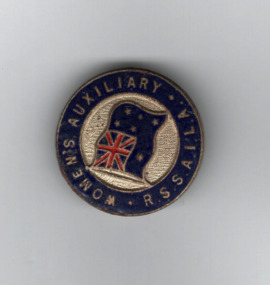
Badge, Women's Auxillary
The Returned Soldiers, Sailors and Airmen Imperial League of Australia was formed in 1916 as welfare group to assist military personnel returning from the overseas active service. In 1965 the organization was renamed the Returned Services League of Australia and assists military personnel, and their families, both past and present. The Women's Auxiliaries assisted in the past with the work of the R.S.S.A.I.L.A. and today assist with the work of the Returned Services League. (The K.G.Luke company was founded in 1925 and continued until the 1980s.)This badge is of interest as one issued by the Women's Auxiliary of the R.S.S.A.I.L.A. It is not known if it has any connection to a local branch of the Women's Auxiliary. Small circular metal badge with dark blue circle around the edge and an Australian flag surrounded by a cream section. Pin on the reverse. Women's Auxiliary RSSAILA. ( Returned soldiers and sailors Imperial league of Australia)women's auxiliaries, returned services league of australia, returned soldiers, warrnambool history -
 Marysville & District Historical Society
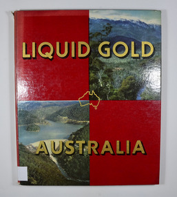
Book, Clive Turnbull, Liquid Gold-Australia, 1960
A book that outlines the importance of irrigation and water usage used in various industries in the Goulburn Valley and North Eastern Victoria.Front cover has two photographs. On of a treed valley leading up to snow covered mountains and on of a water reservoir surrounded by bushland.non-fictionA book that outlines the importance of irrigation and water usage used in various industries in the Goulburn Valley and North Eastern Victoria.water, industry, irrigation, australia -
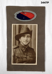 Bendigo Military Museum
Photograph - PHOTOGRAPH WW2, c.1940 onwards
Part of the HEWSTON collection re WW1 & WW2.Sepia photo of HEWSTON family member. Mounted on brown cardboard with WWII colour patch, red / blue insert surrounded by grey.photography-photographs, military history - army -
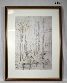 Bendigo Military Museum
Print - SKETCH WW1, FRAMED
Black charcoal / crayon print of sketch of horses resting under trees. Wooden frame, glass covered, cream border surrounds.Handwritten bottom left: “Group under cover, Glisy, A Streeton”illustrations-prints, military history, glass technology, horses -
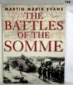 Bendigo Military Museum
Book, The Battles of the Somme
Soft cover with fold in sleeves, cream and red. Photo on front of a tank surrounded by troops. Back cover, photo of a field of poppies books, military / maritime battles -
 Bendigo Military Museum
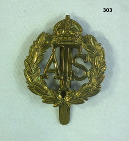
Uniform - BADGE BRITISH, 1930s
The badge belonged to Beryl SCRIMSHAW, W78538 British Forces. Refer 304P, 315.Brass badge with insignia denoting British Auxilliary Training Service. Hook at back. Design of letters 'ATS' surrounded by a wreath and a crown. Engraved on hook,"78538/ W"badges british, military -
 Bendigo Military Museum
Badge - CADET BADGE, 1925
Awarded to Ernest King NEWMAN. Refer Cat No 317 for his pre war and war service in WW11.Round, metal, Australian Senior Cadets badge; Rising Sun insignia in centre, surrounded by a green ring inscrbed 'Recreational Training'Inscribed "1925, 4th Div 2nd State 1st Div Miniature Rifle Shooting/ E K Newman 38th Bn"badges cadet, military, 38th bn -
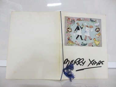 Seaworks Maritime Museum
Menu
Card menu with paper insert. Front has image of a chef and a waiter surrounded by birds. Has a blue string around the middle.Front: "MERRY XMAS" Inside: "We wish you a very merry Xmas/ m.v Halifax Star/ 25th December 1965./ At Sydney/ XMAS DINNER/ Grapefruit Maraschine/ Chilled Orange Juice/ Consomme Royale/ Cream of Tomato/ Seafood Cocktail Darn of Salmon Holondaise/ Chicken Vol au Vente/ Roast Norfolk Turkey Chipolata/ Cranberry Sauce/ POTATOES/ Straw Roast Parsley/ Green Peas Brussel Sprouts Mixed Vegetables/ COLD BUFFET/ Pale Ham Roast Beef Corned Beef/ SALADS/ Asparagus Vinnaigrette Fresh Beetroot & Onion/ SWEETS/ Christmas Pudding and Rum Sauce/ Strawberries & Ice Cream Bartlett Pears and Cream/ Assorted Nuts/ Fresh Fruits/ Assorted Cheeses/ Coffee Biscuits" -
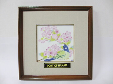 Seaworks Maritime Museum
Framed Tile, Koransha
Porcelain tile in wooden frame featuring image of a blue and green bird surrounded by branches with pink flowers. Below the tile is text.Front: "PORT OF HAKATA" Reverse side: "Presented by/ PORT OF HAKATA DELEGATION (55)/ VICE MAYOR, FUKUOKA CITY/ to DEPUTY CHIEF EXECUTIVE &/ GM COMMERCIAL & TECH SERVICES/ MONDAY 23 OCTOBER 1995" "PMA 0316/1" -
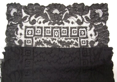 Glenelg Shire Council Cultural Collection
Clothing - Stole, n.d
Black cotton lace stole. Central leaf pattern is surrounded by border of squares and flowers. Outside border is leaf and flower motif. -
Glenelg Shire Council Cultural Collection
Decorative object - Doily, n.d
Doily, round, off white, crochet, star centre surrounded by butterflies, then decorative rounded border. Measures 16.5 cm diameter -
Glenelg Shire Council Cultural Collection
Functional object - Cassette - Ken Robertson Portland, Victoria, n.d
Ken Robertson's Portland Vic songs. 11 songs about Portland and surrounds, written and recorded by Ken Robertson of Swan Hill -
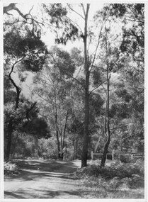
 Halls Gap & Grampians Historical Society
Photograph - B/W
Photo shows old rail bridge, surrounded by bush & passing over what appears to be a creek. Bridge is supported by wooden trestles. structures, bridges -
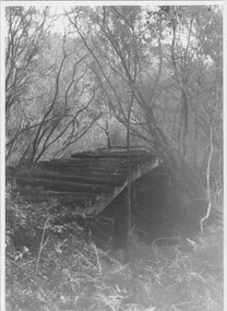
 Halls Gap & Grampians Historical Society
Photograph - B/W, C 1940- (before 1950)
Stoney creek has been 'bridged' a number of times in School Rd, since the creek was re-routed in the early 1900's. A dray bridge was built c1910 by local residents which stood them in good stead for more than a decade.Photo of 'school bridge' over Stoney Creek. Gravel road in foreground leading to a wooden bridge surrounded by tall gum trees.structures, bridges