Showing 3847 items
matching surveyed
-
 Bendigo Military Museum
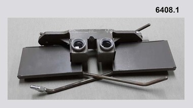
Instrument - Universal Stereoscope, 1940
The Universal Stereoscope was used to view overlapping stereo aerial photography in three dimensions (3D). It consists of magnifying lenses, an optical train including glass prisms and mirrors that are protected by sliding metal covers all suspended on a pair of fold out adjustable legs. The stereoscope is coloured military olive drab green. This Universal Stereoscope was produced in Australia in 1940 for Military use. It was originally produced with a timber protecting carry box that is missing. It was used extensively by members of the Australian Survey Corps during WWII in many theatres of War for viewing and annotating aerial photography. Item 6205.6P, photograph 6205.1P shows the Universal Stereoscope in use by the Australian Survey Corps annotating aerial photography.The Universal Stereoscope was used to view overlapping stereo aerial photography in three dimensions (3D). It consists of magnifying lenses, an optical train including glass prisms and mirrors that are protected by sliding metal covers all suspended on a pair of fold out adjustable legs. The stereoscope is coloured military olive drab green."DC-1940 Serial No 550", "D V D", "Made in Australia" Plate on the underside reads " This stereoscope was donated to the Ex Fortuna Survey Association by the Eaglehawk Recycle Shop February 2015"royal australian survey corps, rasvy, fortuna, army survey regiment, army svy regt, asr -
 Bendigo Military Museum
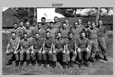
Photograph - A Section, 1st Topographic Survey Troop, Nui Dat, Vietnam, 1969
This is a photograph of A Section, 1st Topographic Survey Troop taken at Nui Dat, Vietnam in 1969. A nominal roll of personnel and their trade as of the 30th of September 1969, accompanies this photo. Their trades in this photo were as follows - Surveyors Topographic: WO1 Darby Munro, SGT Paddy Strunks, SGT Graeme Birrell, CPL Brian Knight, CPL Colin Laybutt, SPR Roderick Gilbert and SPR Rodney Offer. Draughtsmen Topographic: SGT Terrance Linz, CPL Robert Kay, SPR Peter Aukstinaitis, SPR Lloyd Patterson and SPR Ian Wark. Photographer Cartographic: CPL George Graham. Clerk Admin: CPL Oreste Biziak. Helioworker: CPL Geoffrey White, SPR Lance Percey. Cook AACC: PTE R. Johnston. The first Royal Australian Survey Corps troops arrived in South Vietnam on the 10th of June 1966. This was a detachment from 1st Topographic Survey Troop, which was to give cartographic support to the Australian Task Force. Their main tasks were to establish a Theatre Grid, map compilation and map revision. Engineer Survey Support in the camp and to the civil community and give assistance to the Cordon Search Missions by producing large scale plots from aerial photos with every house and fence etc plotted and then reproduce these by silk screening usually, within a 24-hour period. This support concluded with the withdrawal of Australian troops from Vietnam in 1972. For more information on the career of A Section’s OC MAJ Peter Constantine AM, refer to item 6159P or 6092P. He was the CO of the Army Survey Regiment from 1975 to 1976 and CO of the School of Military Survey (SMS) from 1976 to his retirement in January 1982. His memoirs of active duty in Vietnam ‘Surveyor - Printer Behind the Lines’ was published in 2022. 2IC CAPT Frank Thorogood SB St J’s career culminated at the rank of LTCOL as the CO Army Survey Regiment from 1980 to 1981. More information on the A Section, 1st Topographic Survey Troop and the Army Survey Regiment’s supporting role is provided in pages 89 to 94 of Valerie Lovejoy’s book 'Mapmakers of Fortuna – A history of the Army Survey Regiment’ ISBN: 0-646-42120-4.This is a photograph of A Section, 1st Topographic Survey Troop taken at Nui Dat, Vietnam in 1969. The black and white photograph was printed on photographic paper and is part of the Army Survey Regiment’s Collection. The photograph was scanned at 300 dpi. .1) - Photo, black & white, 1969. Back row L to R: SPR Lance Percey, SPR Bruce Grisdale, SPR Rodney Offer, SPR Roderick Gilbert, CPL Geoffrey White, PTE R. Johnston, CPL Colin Laybutt, SPR Lloyd Patterson. Centre row L to R: SPR Peter Aukstinaitis, SPR Ian Hanna, SPR Ian Wark, CPL Robert Kay, CPL George Graham, CPL Oreste Biziak, CPL Brian Knight. Front row L to R: SGT Terrance Linz, SSGT Gordon Haswell, 2IC CAPT Frank Thorogood SB St J, OC MAJ Peter Constantine AM, WO1 Darby Munro, SGT Paddy Strunks, SGT Graeme Birrell.An A4 nominal roll of personnel and their trade accompanies the photo, as of the 30th of September 1969. A torn paper identifies the personnel in the photo. Annotated on back of photo – ‘Unit Photo – 1 Topo Svy Tp 30 Sept 69’royal australian survey corps, rasvy, army survey regiment, army svy regt, fortuna, asr -
 Bendigo Military Museum
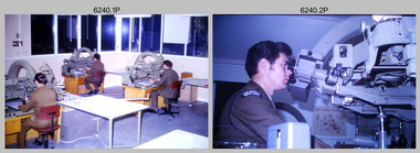
Photograph - Photogrammetric Equipment – Army Survey Regiment, Bendigo and School of Military Survey Bonegilla, c1960s to c1980s
This is a set of 14 photographs of RA Svy technicians operating photogrammetric equipment in Air Survey Squadron, Army Survey Regiment, Fortuna, Bendigo; and the School of Military Survey Bonegilla c1960s to c1980s. The Wild B9 stereo plotter were introduced in 1962 and the Wild B8 stereo plotter was introduced in 1966. The Wild B9 and B8 stereo plotters were used for plotting topographic detail and contours. These analogue machines were manually controlled by adjusting the control knobs for the orientation of the 3D image. The B9s used a four and a half square, and the B8s used a nine-inch square photo image on a film or glass diapositive which allowed highly accurate extraction of map features. At first, plotting with B8 and B9 stereo plotters was undertaken at the aerial photography scale of 1:80,000 in pencil onto a controlled plotting sheet. Sheets were then inked up and reduced photographically to the 1: 100,000 publication scale for scribe impression production. In the early days topographic detail and contours were plotted with a pencil or ink pen mounted at the far end of the pantograph arm. The plotting procedure was upgraded to direct plotting in ink with photographic reduction to publication scale. In 1975 four B8s were upgraded with tri-axis locaters as part of the Input Sub-system to enable digital extraction to AUTOMAP 1’s topographic database. When AUTOMAP 2 was introduced in 1982 these B8s were upgraded, and additional machines added to expand the Army Survey Regiment’s digital capture capability. There are several more photos catalogued in the Victorian Collections database of RA Svy personnel operating Wild B9 and B8 stereo plotters.Photogrammetric Equipment – Army Survey Regiment, Fortuna, Bendigo c.1981. . .7) – Unidentified technician operating Wild B8 stereo plotter in AUTOMAP 1 at ASR. .8) - Wild B8 stereo plotter in AUTOMAP 1 at ASR. Photogrammetric Equipment – Army Survey Regiment, Fortuna, Bendigo. c1981. .9) – ASR’s CPL Dave Cook in AUTOMAP 1 operating a Wild B8 stereo plotter. This is a set of 14 photographs of RA Svy technicians operating photogrammetric equipment at the Army Survey Regiment (ASR), Bendigo and the School of Military Survey (SMS) Bonegilla. c1960s to c1980s. The photographs are on 35mm colour slides and were scanned at 96 dpi. .1) - Photo, colour, c1964. Unidentified ASR technicians operating analogue Wild B9 stereo plotters. .2) - Photo, colour, c1974. ASR’s SPR Mick Minchin operating an analogue Wild B8 stereo plotter. .3) to .6) - Photo, colour, c1980. Photogrammetry Instructor SGT Neil ‘Ned’ Kelly at the SMS operating an analogue Wild B8 stereo plotter. .7) - Photo, colour, c1981. Unidentified technician operating Wild B8 stereo plotter in AUTOMAP 1 at ASR. .8) - Photo, colour, c1981. Wild B8 stereo plotter in AUTOMAP 1 at ASR. .9) to .14) - Photo, colour, c1981. ASR’s CPL Dave Cook in AUTOMAP 1 operating a Wild B8 stereo plotter..1P to .14P - Some of the equipment is annotated on the frame of the 35mm slides.royal australian survey corps, rasvy, army survey regiment, army svy regt, fortuna, asr, photogrammetry -
 Clunes Museum
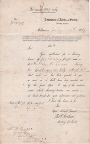
Document - LEASE
LICENCE ISSUED TO MR. PATRICK KEIRCE [INCORRECT SPELLING KIERCE] ON 29TH AUGUST 1870PHOTOCOPY OF LEASE OF LANDASSISTANT COMMISSIONER OF LANDS AND SURVEY. BALLARAT.local history, document, lease, kierce, michael mr. -
 Peterborough History Group
Photograph - Aerial Photograph Peterborough, Department of Crown Lands & Survey, Jan 1971
Aerial photograph showing the past layout of the townSignificant in that it shows the town as it was in 1971.Square 9" x 9" aerial photograph x 4 - (2 photos in duplicate)Stamped Dept of Crown Lands & Surveypeterborough 3270, curdies estuary, bay of islands, crown land photograph, aerial photograph, department of crown lands -
Stawell Historical Society Inc
Archive - Maps, Victorian Government, Bailliere's Country Atlas of Victoria, 1866
Stawell is on Wimmera & Loddon MapLarge Boxed Volume of Maps in Book Burgandy Coloured BoxUnder the Supervision of the Mining and Survey Department -
 Rutherglen Historical Society
Document - License to thin trees, 1899 (Exact)
Dated July 14th 1899. Sent to Mr W. Cooper / c/o Mr Barrie / Storekeeper / No. 2 Valley / Chiltern / "Copy of Land Act 1896 / Regulations. Chapter XI Thinning Licenses"Document on stiff paper. Letter to Mr W. Cooper granting license to thin trees on a block of land at Chiltern Reserve. On back, copy of Land Act Regulations 1890"Department of Lands and Survey. On Forest Business"license, timber felling, cooper family, forestry, chiltern reserve -
 Bendigo Military Museum
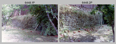
Photograph - New Printing Building Construction, Lithographic Squadron - Army Survey Regiment, Fortuna, Bendigo, c1989
This is a set of 12 photographs of contractors constructing Lithographic Squadron’s new Printing Building at Fortuna, Bendigo circa 1989. The building was purpose built to house a new computer-controlled Heidelberg Speedmaster five colour lithographic offset Printing Press. The print room was named Wayzgoose Hall after a medieval printing house festival. Wayzgoose Hall and the Speedmaster Press printing capability was commissioned by the Commander of the 3rd Military District BRIG P. Davies AM, ADC on Wednesday 27th June 1990. This occasion is covered in more detail in page 145 of Valerie Lovejoy’s book 'Mapmakers of Fortuna – A history of the Army Survey Regiment’ ISBN: 0-646-42120-4. See items 6131.18P and 6444.16P for photos of earlier phases of the construction process.This is a set of 12 photograph of the construction of Lithographic Squadron’s new Printing Building, Army Survey Regiment at Fortuna, Bendigo, c1989. Colour photographs are on 35mm negative film and scanned at 96 dpi. They are part of the Army Survey Regiment’s Collection. .1) to .2) - Photo, colour, 1989. Old stone retaining wall .3) to .12) - Photo, colour, 1989. Construction of new printing building.No personnel are identified. royal australian survey corps, rasvy, army survey regiment, army svy regt, fortuna, asr, litho sqn, printing -
 Victorian Aboriginal Corporation for Languages
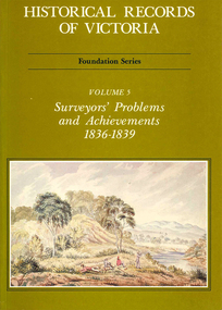
Book, Michael Cannon, Historical records of Victoria : foundation series : volume 5 : surveyors? problems and achievements 1836-1839, 1988
Reproductions of various transactions and reports dealing with the surveying history of Port Phillip, including letters, maps, illustrations, tables, and a detailed history of the surveying of Victoria.maps, b&w illustrations, b&w photographs, tablesvictorian history, port phillip, robert hoddle, monee monee creek, geelong, barwon river, werribee river -
Lakes Entrance Regional Historical Society (operating as Lakes Entrance History Centre & Museum)
Book, O'Keefe, Brendan and Pearson, Michael, Federation. A National Survey of Heritage Places, 1998
A report of the results of a survey of heritage places connected with federation and the making of the Australian Constitution, including the documentation of a trial filed survey of ten selected places.federation, constitution, heritage -
 Bendigo Military Museum
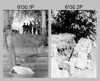
Photograph - Vehicle in Lake Incident - Army Survey Regiment, Fortuna, Bendigo, 1986
This is a set of 12 photographs of contractors removing a vehicle from the lake at the Army Survey Regiment, Fortuna, Bendigo in September 1986. The Ford XB panel van belonging to WO2 Ted Burgess rolled down the embankment during the night from the SGTs Mess carpark. Despite written off by the insurance company, the panel van was remarkably restored by Ted to roadworthy condition and driven in to Fortuna with a shark’s fin mounted on its roof. This incident is covered in more detail in page 152 of Valerie Lovejoy’s book 'Mapmakers of Fortuna – A history of the Army Survey Regiment’ ISBN: 0-646-42120-4.This is a set of 12 photograph of a civilian vehicle being removed from the lake at Army Survey Regiment at Fortuna, Bendigo, September 1986. The photographs were on 35mm negative film and were scanned at 96 dpi. They are part of the Army Survey Regiment’s Collection. .1) to .3) - Photo, black & white, 1986. Vehicle removal from lake. .4) - Photo, black & white, 1986. Vehicle removal from lake, Neil Morgan in foreground. .5) to .8) - Photo, black & white, 1986. Vehicle removal from lake. .9) to .10) - Photo, black & white, 1986. Vehicle removal from lake, Neil Morgan on right. .11) to .12) - Photo, black & white, 1986. Vehicle removal from lake.No personnel are identified. Annotated with date on negative sleeve.royal australian survey corps, rasvy, army survey regiment, army svy regt, fortuna, asr -
 Bendigo Military Museum
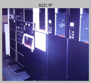
Photograph - Aerotriangulation Production – Army Survey Regiment, Fortuna, Bendigo, c1970s to 1980s
This collection of 14 photos was most likely taken in the 1970s and 1980s in Air Survey Squadron. The PDP 11/70 minicomputer shown in photo .1P was the operating system introduced in 1977 as the mainframe system for the control of the APC4, aerial triangulation block adjustments, SORA OP Analytical Orthophoto control, APR Analytical Terrain Profile Recorder computation, graphics, and general computing. Technicians used the Wild A9 Stereocomparator shown in photo .2P to accurately measure between pass, tie, and survey control points on aerial photographs. The Zeiss D2 Planimat Stereoplotter shown in photos .3P to .4P was used for analytical orthophoto control. It was introduced in 1972-1973 The Zeiss (Jena) Stecometer analytic stereocomparator for air photography shown in photos .5P to .11P and .14P was introduced at Air Survey Squadron in 1963. Aerotriangulation production was expedited using computers for analytical photogrammetric processes. The technician accurately measured between pass, tie, and survey control points on aerial photographs. Wild PUG4 point transfer devices shown in photos .12P to .13P were introduced in c1968 superseding the PUG2 devices. PUG4 devices were used by technicians to stereoscopically view the photography containing the survey control points and the mapping aerial photography. The Control points were transferred from the control photography to the mapping diapositives of aerial photography by drilling their locations into the photographic emulsion.This is a set of 14 photographs of Air Survey Squadron personnel operating aerotriangulation equipment at the Army Survey Regiment at Fortuna, Bendigo, c1970s to 1980s. Photographs .1P to .13P were on 35mm colour slide film and scanned at 96 dpi. Photograph.14P was printed on photographic paper and was scanned at 300 dpi. They are part of the Army Survey Regiment’s Collection. .1) - Photo, colour, c1979, PDP-11 minicomputer. .2) - Photo, colour, c1970s, Unidentified technician operating a Wild A9 Stereocomparator. .3) - Photo, colour, c1970s, Zeiss D2 Planimat Stereoplotter. .4) - Photo, colour, c1970s, Zeiss D2 Planimat Stereoplotter, unidentified technicians. .5) - Photo, colour, c1970s, Zeiss D2 Planimat Stereoplotter, SGT Christopher Wardley. .6) - Photo, colour, c1970s, Zeiss D2 Planimat Stereoplotter. .7) to.9) - Photo, colour, c1970, Zeiss (Jena) Stecometer, unidentified technicians. .10) to.11) - Photo, colour, c1988, SPR Toni Wright operating a Zeiss (Jena) Stecometer. .12) - Photo, colour, c1970s, Wild PUG4 point transfer device, SPR John Shepard. .13) - Photo, colour, c1970s, Wild PUG4 point transfer device, SPR David Edwards. .13) - Photo, colour, c1970s, Wild PUG4 point transfer device, SPR David Edwards. .14) - Photo, colour, c1980, Zeiss (Jena) Stecometer, SGT Bruce Hammond.Some of the equipment is annotated on the frame of the 35mm slides.royal australian survey corps, rasvy, army survey regiment, army svy regt, fortuna, asr, aerotrig, photogrammetry -
Stawell Historical Society Inc
Map, Gold Mines of Australia, Gold Mines of Australia underground workings. Newington Rd Darlington Rd Area 1950, 1950
Plans Showing Surveys & Drilling Stawell InvestmentGold Mines of Australia Stawell Investment 2003 mining, gold, map -
 Port Fairy Historical Society Museum and Archives
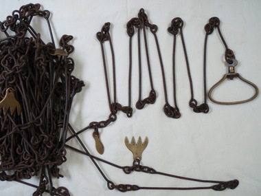
Functional object - survey chain
metal surveying chain with brass markers and handlesJames Beddington "Warranted correct"local history, surveying, terrestrial, survey chain beddington -
 Bendigo Military Museum
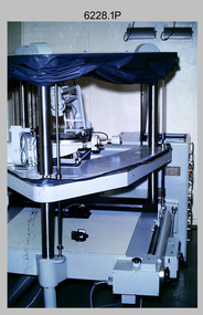
Photograph - Orthorectification Equipment - Army Survey Regiment, Fortuna, Bendigo, c1975, c1988
Orthophoto mapping provided the Survey Corps with the capability to produce map products quickly in the event of a crisis. These are four photographs of equipment used by the Army Survey Regiment to produce orthophotomaps. The Wild GZ1 orthophoto projector shown in photo.1P was introduced in 1973 and was the first equipment used to orthorectify colour and monochrome film aerial photography. Height profiles were originally produced on a PEB8 Stereo profiler and later were software generated. Photos of the PEB8 are available in Victorian Collections item 6222.17P, photos .5P and .6P. In the same era the IBM 1130 computer; OMI/Nistri AP/C-3 analytical plotter with coordinatograph, OP/C orthophoto projector and Zeiss Planimat D2 stereoplotters were introduced. Orthorectification is the process of removing geometric distortions and scale errors/variations from images. Images have tilt and relief distortions that make it difficult to compare accurately a map and an image of the same geographic area. Once an image is orthorectified, features on the image are shown in their planimetric locations. The WILD OR1 orthophoto projector and workstation shown in photos .2P to.4P was introduced in the mid-1980s. It was the second-generation equipment used to orthorectify colour and monochrome film aerial photography, replacing the system introduced in 1973. See items 6124.5P and 6133.4P for more photographs of orthorectification equipment.These four photographs of orthorectification equipment were taken at the Army Survey Regiment at Fortuna, Bendigo, c1975 and c1988. The photos are on 35mm colour slides and scanned at 96 dpi. They are part of the Army Survey Regiment’s Collection. .1) - Photo, colour, c1975, Wild GZ1 orthophoto projector. .2) - Photo, colour, c1988, WILD OR-1 unrectified colour photo in carrier, orthorectified and re-scaled colour image. .3) & .4) - Photo, colour, c1988, WILD OR-1 Orthorectification Workstation.1P to .4P – Some of the equipment is annotated on the frame of the 35mm slides.royal australian survey corps, rasvy, army survey regiment, asr, army svy regt, fortuna -
 Queenscliffe Maritime Museum
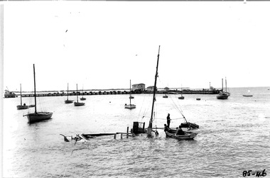
Photograph - Sinking of the Ports & Harbour launch "Flinders", Photographer unknown, Photographs
Photos of the Ports & Harbour launch "Flinders' at anchor prior to sinking.Realism, historical1. Envelope of Notes 2. Page 1 of 3 Notes re Photos 46 to 54. 3. Page 2 of 3 Notes re Photos 46 to 54. 4. Page 3 of 3 Notes re Photos 46 to 54. 5. Photo of sunk Flinders and Bass towing it 6. Reverse of photo showing notes.On the reverse - " P2A49 - Couta boats in background - Sunk boat - FLINDERS - P&H survey launch - 1953 - Ports & Harbours survey launch with tow rope - P&H Survey Launch BASS" -
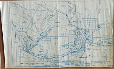 Orbost & District Historical Society
survey, 1941
this item is a useful reference tool.A survey map produced by the State Rivers and Water Supply Commission. It is on white paper with blue ink. It is a hand-drawn survey of the Snowy River in 1939-40.survey map snowy-river -
 Bendigo Historical Society Inc.
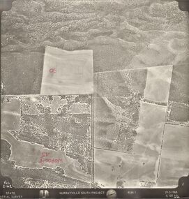
Photograph - MURRAYVILLE SOUTH PROJECT
State Aerial Survey. A set of aerial surveys related to the Murrayville South Project. Run 1. Vic. 2162. 29-2-1968. 53 photos.photograph, aerial, murrayville south project, photos, murrayville south project, state aerial survey, surveys, murrayville, photographs, photography, aerial photography -
 Victorian Aboriginal Corporation for Languages
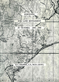
Book, K L Chappel, Surveying for land settlement in Victoria 1836-1960 : survey of the Vic-NSW boundary, survey of the Vic-SA boundary, 1996
A record of the early history of surveying for land settlement. Includes appendices on the border surveys between Victoria and South Australia and between Victoria and New South Wales.maps, b&w photographs, illustrationssurveying, land settlement -
University of Melbourne, Burnley Campus Archives
Plan, Plan of the Melbourne Botanic Gardens, 1948
Partially coloured plan on a grid. Prepared from Field Notes of Survey by F.C. Ridoutt drawn and reproduced at the Dept. of Lands & Survey, Melbourne, March 1948.f.c. ridoutt, gardens, melbourne -
 Bendigo Military Museum
Photograph - Photo Troop Equipment, Lithographic Squadron – Army Survey Regiment, Fortuna, Bendigo, c1970s
This collection of five photos was most likely taken at Lithographic Squadron, Army Survey Regiment, Fortuna, Bendigo in c1970s. The main tasks undertaken by technicians in Photo Troop were most likely enlargements, reductions and duplication of map reproduction material, and processing of aerial photography.This is a set of five photographs of Photo Troop equipment was taken in Lithographic Squadron, at the Army Survey Regiment, Fortuna, Bendigo, c1970s. The photographs are on 35mm colour slides and were scanned at 96 dpi. They are part of the Army Survey Regiment’s Collection. .1) - Photo, colour, c1970s, WILD U4A Diapositive Camera. .2) - Photo, colour, c1970s, Hass-Labortechnik Film and Paper Roller Transport Processor. .3) - Photo, colour, c1970s, Hass-Labortechnik Film and Paper Roller Transport Processor, SGT Christopher Wardley. .4) - Photo, colour, c1970s, Hass-Labortechnik Film and Paper Roller Transport Processor, unidentified technician. .5) - Photo, colour, c1970s, Pako Film Processor..1P to .5P – Some of the equipment is annotated on the frame of the 35mm slides.royal australian survey corps, rasvy, army survey regiment, army svy regt, asr, fortuna, litho -
Whitehorse Historical Society Inc.
Document, EastLink, 2005-2008
Miscellaneous brochures, newsletters and notices distributed to local residents about aspects of the construction of the EastLink tollway.Miscellaneous brochures, newsletters and notices distributed to local residents about aspects of the construction of the EastLink tollway. Includes partial runs of EastLink News March 2005-June 2008, EastLink Construction Update December 2005-February 2008, and Community Connect Forum papers and Property Condition Survey Report for 7 May Court Mitcham.Miscellaneous brochures, newsletters and notices distributed to local residents about aspects of the construction of the EastLink tollway. may court, mitcham, no. 7, freeways, roads and streets, seita, thiess john holland, vicroads, victoria. department of infrastructure, mitcham frankston project. community connect forums -
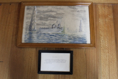 Lara RSL Sub Branch
Painting of H.M.A.S. Whyalla off New guinea, 1944
WW2, H.M.A.S. WhyallaWW2, H.M.A.S. Whyalla painting1. Painting of H.M.A.S. Whyalla on survey duty off New Guinea in 1944 , framed in glass and wooden frame. 2. Separate small framed statement of the painting with details of the action being under-taken by H.M.A.S. Whyalla. hanging from the paniting frame middle/centre.H.M.A.S. Whyalla In 1944, while on survey duty off New Guinea, in preparation for a landing by infantry, H.M.A.S. Whyalla was attacked by by Japanese aircraft. This is a portrayal of the attack, painted by a member of the crew it was presented to Lara R.S.L. in March 1981 by Lindsay Dunsmuir, also a member of the crew. Artist name B. Andeasenww2, lindsay d. dunsmuir,, 1944 -
 Bendigo Military Museum
Photograph - Photo Troop, Lithographic Squadron - Army Survey Regiment, Bendigo, 1989
This is a photograph of Photo Troop, Lithographic Squadron; one of the Army Survey Regiment’s four squadrons, at Fortuna, Bendigo, December 1989. The main tasks undertaken by Photo Troop’s technicians were most likely photographic enlargements, reductions and duplication of map reproduction material, and processing of aerial photography.This is a photograph of Photo Troop Lithographic Squadron, Army Survey Regiment at Fortuna, Bendigo, 1989. The colour photograph was printed on photographic paper and is part of the Army Survey Regiment’s Collection. The photograph was scanned at 300 dpi. Back Row L to R: Rob Bogumil, Kevin ‘Chuck’ Berry, Andrew ‘Morrie’ Morrison-Evans, unidentified, Greg Howell, unidentified, Damien Cole, unidentified, Warren ‘Waldo’ Shirley, Steve Burke, Paul Baker, Bob Garritty, Frank Lenane, Bill Jones. Front Row L to R: John Bragg, Ken Peters, Gavin Craggs, Michelle Withers, Penny Knott, Di Chalmers, Geoff Webb, unidentified, Darren ‘Barney’ Maher, Kim Reynolds. No personnel are identified. Annotated on back with ‘Photo Troop Dec 1989’royal australian survey corps, rasvy, army survey regiment, army svy regt, fortuna, asr, litho -
 Bendigo Military Museum
Pamphlet - An Introduction to Topographic Mapping, C 1991
This pamphlet was published by the Army Survey Regiment as an overview of the Royal Australian Survey Corps (RASvy), its role and unit structure circa 1991, prior to RASvy’s disbandment in 1996. The pamphlet comprehensively detailed the eight steps of topographic map production: Establish Survey Control, Aerial Photography, Aerotriangulation, Stereoplotting, Field Verification, Cartography, Printing and Storage/Map Distribution. Leading technologies used by RA Svy in 1991 included GPS control surveys, 5 colour printing on the Speedmaster offset press and bulk map packaging using the Map Handling Station (with guillotine). Digital map production was operating on the AUTOMAP 2 system, before the “Newheart” system upgrade two years later. Printed on the pamphlet cover was a portion of the plane tabled “four inches to a mile” map of Newcastle. This was compiled and surveyed in 1910 by LCPL A. Barrett, a member of the RAE Detachment, as part of the first major topographic mapping effort of Australia.This is a Royal Australian Survey Corp pamphlet with a historical map printed in colour on cardboard on both sides of the cover. There are 16 pages printed in colour on gloss paper, with photos, diagrams and descriptions. The pamphlet is bounded by two staples on its spine. Each of the 17 images were scanned at 300 dpi in JPEG (.jpg) format and stored on the attached 16 Gb USB memory stick. The images have been converted into MPEG-4 (.mp4) video format, 4Mb in size and runs for 2:16 minutes and is also stored on the memory stick.royal australian survey corps, rasvy, fortuna, army survey regiment, army svy regt, asr -
4th/19th Prince of Wales's Light Horse Regiment Unit History Room
Booklet, Australian Army Manual of Land Warfare Part 2 Artillery Training Vol 3 Pam 3 Gun Regiments Survey within the Unit 1983, 1983
Soft covered booklet describing the principles and process of battery survey in a field artillery battery and that within the regiment, and the role organisation duties and deployment of a regimental survey section 7610-66-108-8454artillery, survey -
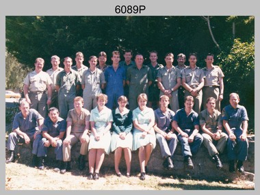
 Bendigo Military Museum
Photograph - AHQ Survey Regiment Open Day - c1970, c1970
This is a set of thirty photographs of an Open Day held at the AHQ Survey Regiment, Bendigo c1970. It’s evident in these photos there was also a technical tour for dignitaries through the production areas in Air Survey, Cartographic and Lithographic Squadrons. It is known an Open Day coincided with the Freedom of Entry to the City Parade, an honour that was conferred by the Bendigo City Council to the AHQ Survey Regiment and held on the 14th of June 1970. As the CO LTCOL Bill Sprenger is positively identified, it’s highly probable these photos were taken at that time.This is a set of photographs of an Open Day held at the AHQ Survey Regiment, Bendigo c1970. The photographs were printed on photographic paper and are part of the Army Survey Regiment’s Collection. The photographs were scanned at 600 dpi. .1) to .17) - Photos, black and white. Unidentified personnel and civilian visitors. .18) and .19) - Photos, black and white. CO LTCOL Bill Sprenger is wearing Sam Browne belt. .18) and .19) - Photos, black and white. CO LTCOL Bill Sprenger is wearing Sam Browne belt. .20) and .21) - Photos, black and white. Left rear: SPR John Bennett .22) - Photo, black and white, c1970. Unidentified personnel and civilian visitors. .22) - Photo, black and white, c1970. Unidentified personnel and civilian visitors. .23) - Photo, black and white. L to R: 1st CO LTCOL Bill Sprenger, 3rd WO1 Joe Farrington .24) - Photo, black and white. L to R: 2nd SGT Bob Williams .25) - Photo, black and white. Unidentified personnel .26) - Photo, black and white. L to R: 2nd CO LTCOL Bill Sprenger. .27) to .30) - Photos, black and white. Unidentified personnel and civilian visitors.royal australian survey corps, rasvy, army survey regiment, army svy regt, fortuna, asr -
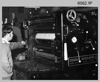 Bendigo Military Museum
Photograph - Original Heidelberg Printing Press at the Army Survey Regiment, c1980s, 1990
The first three photographs of the Original Heidelberg Printing Press were probably taken circa 1980s in Lithographic Squadron at the Army Survey Regiment, Fortuna, Bendigo. The last photo was taken in 1990. The Original Heidelberg Printing Press was a single colour offset press. It was a robust and well-made lithographic printing press and was in service at the Army Svy Regt for decades. Its primary use was for initial training and rapid response tasks, such as single pass overprints over existing print stock.This is a set of photographs of the Original Heidelberg Printing Press at the Army Survey Regiment, Bendigo c1980s, 1990. The photographs were printed on photographic paper and are part of the Army Survey Regiment’s Collection. The photographs were scanned at 300 dpi. .1) - Photo, black & white, c1980s, SPR Mick Ellis, Lithographic Squadron .2) - Photo, black & white, c1980s, unidentified, Lithographic Squadron .3) - Photo, black & white, c1980s, SPR Terry Winzar, Lithographic Squadron .4) - Photo, colour, 1990, Ni Vanuatu Printer Technicians, Lithographic Squadron.1 – personnel annotated .2 to .3 – no annotation .4 – annotated with dateroyal australian survey corps, rasvy, army survey regiment, army svy regt, fortuna, asr, litho, printing -
Federation University Historical Collection
Report, City of Stawell Accessibility Study for the Disabled
A folder of information and surveys relating to disability access in Stawell -
 Federation University Historical Collection
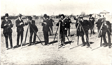
Photograph - Photograph - Black and White, Ballarat School of Mines Surveying Students
This group was possibly at White Flat, Ballarat.A group of Ballarat School of Mines surveying students 'in the field'. surveying, ballarat school of mines, class, surveying students, theodolite, student activity