Showing 15880 items
matching areas
-
 Rutherglen Historical Society
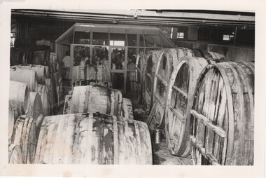
Photograph - Image, 1970s
Located within the heart of the winery, the atrium style Cellar Door was designed by legendary Australian architect; Robyn Boyd and constructed in 1972. Offering views of the century old storage casks and famous dirt floors, the Cellar Door offers an up close experience to the making of our world famous wines.Black and white photograph of the interior of a wine cellar with stacks of wine casks of various sizes. A substantial number of people are in a glassed-in area at the back of the room. Glassed-in area ( cellar door sales area) designed by Robyn Boyd. 1972On back of photo: "S/S [upper case H in a circle] Morris"wineries, north east victoria, wine industry, morris winery, robyn boyd, rutherglen australia, winery, cellar door -
 Numurkah & District Historical Society
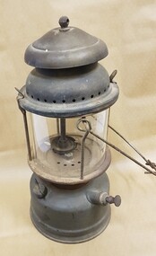
Kerosene Lamp
Metal cylindrical base to store kerosene. Above this area is a cylindrical glass area for the actual lamp light. Above this is a metal cylindrical cover with perforated holes for venting fumes. A thick metal wire handle is attached to the sides of the lamp. Access to the inside of glass area is via two spring-loaded clamps on either side of the glass area.On glass: Pyrex, Aladdin, Made in Australialamp, light, lantern, kerosene -
 Whitehorse Historical Society Inc.
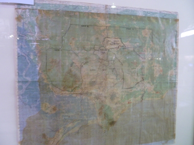
Map, City of Nunawading, 1973
Map showing streets, plot numbers, schools, open space and land usage.Map showing streets, plot numbers, schools, open space and land usage. A project by A Gray, student at Vermont High School. Area covered from Canterbury Road to Burwood Road and Terrara Road to Morack Road. Scale: 800 ft: 1 inchMap showing streets, plot numbers, schools, open space and land usage.vermont south, vermont, vermont high school, parks and reserves -
B-24 Liberator Memorial Restoration Australia Inc
Map - Silk Map of South West Pacific Ocean, Ocen Currents and Surface winds of the West pacific Area May-October
These maps were carried by air crew flying in the Pacific Ocean areas.Square silk mapOCEAN CURRENTS AND SURFACE WINDS FOR THE WEST PACIFIC AREA MAY- OCTOBER COMPILED BY THE 2ND AND 3RD OPERATIONS ANALYSIS SECTIONS,HQ, FEAF, FROM OCEAN CURRENT CHARTS DEIGNED BY THE SCRIPTS INSTITUTE OF OCEANOGRAPHY, AND FROM WIND CHARTS PREPARED BY THE U.S. WEATHER BUREAU. REPRODUCED BY R.A.A.F HEADQUARTERS [cartographic section] OCTOBER 1944 RESTRICTED -
 The Beechworth Burke Museum
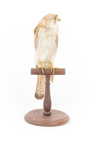
Animal specimen - Nankeen Kestrel, Trustees of the Australian Museum, 1860-1880
The Nankeen Kestrel, a small type of falcon, can be found all over Australia, usually in grassland or farmland areas. This falcon is carnivorous and hunts all manner of small prey including mice, lizards, insects, and other birds. When hunting, Nankeen Kestrels can be seen hovering in the air searching for prey. Nankeen Kestrels are generally monogamous, staying with the same breeding partner for multiple seasons. The Nankeen Kestrel is known for its reddish-brown feathers, spotted with a distinctive black pattern on its back, and have black-tipped wings and tail band, a stark contrast to its white chest. Females tend to be larger, and males will have a grey head and neck area. This specimen is part of a collection of almost 200 animal specimens that were originally acquired as skins from various institutions across Australia, including the Australian Museum in Sydney and the National Museum of Victoria (known as Museums Victoria since 1983), as well as individuals such as amateur anthropologist Reynell Eveleigh Johns between 1860-1880. These skins were then mounted by members of the Burke Museum Committee and put-on display in the formal space of the Museum’s original exhibition hall where they continue to be on display. This display of taxidermy mounts initially served to instruct visitors to the Burke Museum of the natural world around them, today it serves as an insight into the collecting habits of the 19th century.This specimen is part of a significant and rare taxidermy mount collection in the Burke Museum. This collection is scientifically and culturally important for reminding us of how science continues to shape our understanding of the modern world. They demonstrate a capacity to hold evidence of how Australia’s fauna history existed in the past and are potentially important for future environmental research. This collection continues to be on display in the Museum and has become a key part to interpreting the collecting habits of the 19th century.This female Nankeen Kestrel is relatively small and slender. It is mostly reddish-brown, streaked with darker coloured areas. The tips of the wings and tail feathers are tipped in black. The chest is white with streaks of reddish-brown. The areas around its eyes, beak, and feet are a bright yellow. This specimen stands upon a wooden platform and has an identification tag tied around its leg.Swing-tag: 19. / Unnamed / Catalogue page, 5 /taxidermy mount, taxidermy, animalia, burke museum, beechworth, australian museum, skin, nankeen kestrel, falcon -
 Bacchus Marsh & District Historical Society
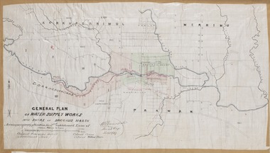
Map, General Plan for Water Supply Works, Shire of Bacchus Marsh 1887
Debate about water supply and its planning and development took place in the Bacchus Marsh region from the 1850s through into the twentieth century. This plan was part of documentation to support an application for an additional loan of money from the Ministry of Water Supply to the Bacchus Marsh Shire Water Supply Trust. The plan includes the route of a proposed water channel in the Parwan area, and other features of water supply infrastructure such as the location of standpipes and gates are also shown on the plan.A single page paper map showing a general plan for the supply of water in the Bacchus Marsh area.The plan shows the route of the 'Main Channel' near the Werribee River and a proposed route for a Parwan Channel. The location of 'Dryden's House' near the Werribee River is also shown and the locations of land held by T. (Tom) Oliver and the Racecourse Reserve in Maddingley. Scale 40 chains to 1 inch. The plan is signed by Bacchus Marsh Shire Engineer, W.E. Standfield. The map is pasted into a bound volume containing 76 maps or plans in total. High resolution digital image stored on BMDHS computer network. General Plan of Water Supply Works in the Shire of Bacchus Marsh. Accompanying application for 2nd additional Loan. Original Waterworks district. Additional area. W.E. Standfield, 30/8/87.water supply, water supply maps, water supply bacchus marsh, irrigation, bacchus marsh victoria maps -
Glenelg Shire Council Cultural Collection
Slide - Slide - Cashmore Airport, Portland, 1980s
Coloured slide. Flat green area of land in foreground, then a body of water, then sandy area with several earth moving vechicles, hill in background.portland airport, construction, engineering, cashmore -
Port Melbourne Historical & Preservation Society
Plan - Melbourne and suburbs sewerage works, MMBW, 1 Jul 1908
MMBW map of Melbourne and Suburbs sewerage work to 1-7-1908. Reticulation areas in red, reticulation areas under construction in blue.engineering - canals and drainage, engineering - board of works -
 National Vietnam Veterans Museum (NVVM)
Map, Long Tan Original Battle Map
Original topographical map of Long Tan area showing operational marking in black pen. Areas 1-4 marked 5RAR section.This map is the original map from 1 ATF HQ on the day of the Battle of Long Tan, 18th August, 1966.battle of long tan, map -
 Clunes Museum
Photograph
COLOURED PHOTOGRAPH TAKEN BELOW FORD AT END OF FRASER STREET. AREA NOW USED AS PICNIC AREA ON CREEK BANK ON BLACKMORE ROAD.local history, photography, photographs, clunes landscape -
 Mt Dandenong & District Historical Society Inc.
Photograph
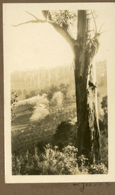
The photograph is from the album of Ivy May Child. It shows a view across the holding of Walter Jeeves. Walter was the second son of Ellis Jeeves and grandson of Isaac Jeeves, the pioneer. Walter was given the house 'Kalorama' and 20 acres of lnd - most of it sloping. He established a commercial garden, initially growing vegetables but later flowers and shrubs. This land now forms part of Kalorama Park. The building in the photograph is the Kalorama Homestead with shrubs and trees planted in rows on the sloping site. Ivy May Child (1910 – 1989) was the daughter of Arthur Edward (Ted) Child (1878 – 1964) and Ethel May Madden (1888 – 1970). Ted Child was the son of Matthew Francis Child (1839 – 1933) and Martha Jeeves (1857 – 1926). He was the grandson of one of the early pioneers Francis Child. Ivy grew up on the family property on Childs Road and took many photographs. Most of these are glued into her photo album. The album covered the years from c1927 – 1932. Ivy married Henry William Burgess (1906 – 1968) in 1944. The photographs remain in their original state in the album with individual copies made. Black and white photograph with a large gum tree in the foreground, a sloping area of cleared, cultivated land and homestead in the centre and a forested area in the distance.An inscription below the photograph in the album reads: W. JEEVESwalter jeeves, jeeves, kalorama homestead, kalorama park -
 Mt Dandenong & District Historical Society Inc.
Photograph
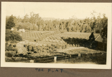
The photograph is from the album of Ivy Child. It shows a homestead with a heavily cultivated area behind. It is possibly the Child Homestead. Ivy May Child (1910 – 1989) was the daughter of Arthur Edward (Ted) Child (1878 – 1964) and Ethel May Madden (1888 – 1970). Ted Child was the son of Matthew Francis Child (1839 – 1933) and Martha Jeeves (1857 – 1926). He was the grandson of one of the early pioneers Francis Child. Ivy grew up on the family property on Childs Road and took many photographs. Most of these are glued into her photo album. The album covered the years from c1927 – 1932. Ivy married Henry William Burgess (1906 – 1968) in 1944. The photographs remain in their original state in the album with individual copies made. Sepia photograph taken in bright sunshine showing an extensively cultivated area with a wire fence in the foreground. Three buildings are seen at centre left.Handwritten below the photograph in the album" THE FLATivy child, kalorama, crops, cultivation, homestead -
 Kiewa Valley Historical Society
Maps 3D - National Parks
Used by the employees of National Parks. The maps show the topography and contours in 3D when used with the stereoscope KVHS 0743. This enables the photographed area to be compared to previous photos and enables the planning of construction of eg. new roads etc. Digital information is now available.These photographs give the topography and contours of vast local areas eg. Mt Feathertop and Tawonga township.when used with a stereoscope. Black and white large aerial photos of the Bogong High Plains area. 14 to 20 of them all on thick paper and the same size as the brown wooden box which holds them. The box hasn't got a lid at the top.Identified and catalogued by National Parksmaps showing topography, national parks, stereoscope -
 Glenelg Shire Council Cultural Collection
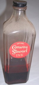
Functional object - Bottle, n.d
In 1905, Mr. Frank Jarvis and Mr. Tommy Garner formed Conway Stewart & Co. Limited at 13 Paternoster Row EC1, next to St Paul’s Cathedral in London. Today, this area is known as Paternoster Square having been redeveloped after its complete destruction during the Blitz of World War II. Although there is much debate regarding the origins of the Company’s name, it is believed that the name “Conway Stewart” derives from a popular vaudeville act of the day. Conway and Stewart were supposedly a comedy double act who appeared at Collins Music Hall in Islington. The two entrepreneur took a great risk in leaving their secured jobs to start a new enterprise reselling fountain pens made by other manufacturers. They concentrated their energies and invested in importing pens from the United States. After an arduous month of persistent selling of their stock, they reaped the rewards of a rather healthy turnover of more than £13 and 9 shillings. This was a great accomplishment considering that the rent for their business premises was only five shillings a week. Even though this turnover would be pleasing to many new ventures, the strength of De La Rue in the fountain pen market made it impossible for the company to continue selling no-named fountain pens. In the same year, De La Rue reportedly invested £50,000 in a promotion campaign for their new launch, the Onoto. However, Garner and Jarvis soon recognized there was an audience desiring good, reliable writing instruments that were also affordable. This is when Conway Stewart began to capture a market amongst the English. Jarvis and Garner developed a single aim, to produce elegant and beautiful, yet functional writing instruments – a principle that Conway Stewart holds true to this day.Red "Conway Stewart Ink" bottle with black metal lid and red round label. Square bottle with flat edges. One quarter filled with ink.Front: 20 fl. ozs./Conway/Stewart/ink (white letters on red background, label, upper area of bottle)ink, writing, bottle -
Whitehorse Historical Society Inc.
Article, Farm digs in against closure, 2013
Land reserved for Healesville Freeway is at risk of being broken up for housing.Land reserved for Healesville Freeway is at risk of being broken up for housing. Some of the area is used at present for a farm run by NADRASCA, and other land is the nature reserve, Bellbird Dell. More than 1500 protested against the closure to local MP Shaun Leane.Land reserved for Healesville Freeway is at risk of being broken up for housing. healesville freeway reservation, bellbird dell, nadrasca, leane, shaun, vermont, koedyk, gus, turner, raeoni, kayne, rodney, basic, peter, vicroads -
 City of Kingston
Photograph - Black and white, 20 December 1945
This aerial photograph depicts the changing landscape of Cheltenham and Highett since WWII. Photographed in 1945, there is a mix of urban dwellings and industrial development and precedes the major transformation of Cheltenham with the development of the Southland shopping centre in the 1960s and expansion in the 1990s.A large part of Cheltenham was originally established as a rural market gardening community. The railway line and station brought urban development to the area and in the north, the Highett area was dominated by the Highett Gas Works. Cheltenham became a major destination for shopping in the 1960s with the opening of Southland.Aerial photograph taken in 1945 of Cheltenham and Highett within the City of Kingston. The image includes the Highett Reserve, (top right), the Methodist Children Homes (now Southland), Nepean Highway and Jamieson Street. Highett Gas Works is visible in the top left and the land now named William Fry Reserve at the intersection of Bay Road and Nepean Highway. A visible large parcel of land on the corner of Bay Road and Nepean Highway was developed in the 1990s as the west side addition to Southland. The densely vegetated area in the upper right sector of the image is now dense with housing. Tulip Grove, Heather Grove and Gilford Street are visible bottom left. This image is possibly from the collection of aerial photographs commissioned by the Department of Crown Lands and Survey and taken by Adastra Airways.Black type: Reverse lettering VIC-10 57252 20.12.45 [lens information indecipherable] PROJ. No.5 MELB. METROP AREA White lettering: Reverse writing 57252cheltenham, highett, highett gas works, urbanisation -
 Wycheproof & District Historical Society Inc.
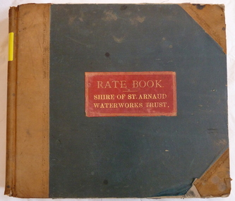
Register - Rate Book, Rate Book Shire of St.Arnaud Waterworks Trust. Wycheproof 1893-1908, 1893
First recorded Waterboard Rate book for Wycheproof which was then under the St.Arnaud Shire. Early in 1893 the burning question in the north-central area was the possibility of severance from the St.Arnaud Shire On April 27,1894 the Shire of Wycheproof was constituted. Earliest Rate records for early Wycheproof residents 1893 - 1908 and property owners. Nine councillors elected to represent the new Shire of Wycheproof.Rate book -St.Arnaud Waterboard records Wycheproof Rate payers for Urban area 1893 - 1908. It comprises Surnames, Christian Names, Trade, Postal Address, Owner, Description and Situation of Rateable Property, Rates per Annum in the Pound and other details.water-rates, register, st.arnaud - shire, urban-wycheproof -
Glenelg Shire Council Cultural Collection
Photograph - Photograph - Portland Harbour, Aug-89
Port of Portland Authority ArchivesBack: 'Henty Beach area 'slip' and infill August 89' - black biroport of portland archives -
 Ringwood and District Historical Society
Photograph, Cleared area in Bond and Charter Streets. Ringwood 1982 (4 views)
Catalogue card reads, "Ringwood, 1982.Cleared area in Bond and Charter Streets." -
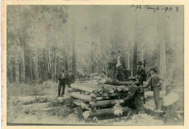 Mt Dandenong & District Historical Society Inc.
Photograph, Olinda Rifle Range 1903
Scene showing 12 men at the Olinda Rifle Range in 1903. One man firing rifle. Reverse of photograph has handwritten description by John Lundy-Clarke.The Rifle Range at Olinda 1903. Was in the area of the Rhododendron Gardens by Georgian Road and the GolfLinks.olinda, rifle range -
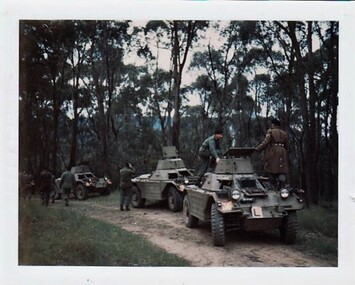 8th/13th Victorian Mounted Rifles Regimental Collection
Photograph
In 1965, 8th/`3th Victorian Mounted Rifles was equipped with wheeled armoured vehicles and undertook its own driver instruction training. Weekend training so as to have trained crewmen available for tactical training at Annual Exercises.Collection of photographs showing an armoured regiment of the Citizen Forces in the 1960s as it transitioned from wheeled armoured vehicles to tanks to M113 armoured personal carriers.Coloured photograph of three Ferret Scout Cars on bush road. Vehicles have " L " plates displayed." Ferret Driving Course around Granya ( Victoria ) area. Cpl. Halliday in overcoat. " -
 Kew Historical Society Inc
Photograph - Road works in East Kew, 1977
One of a series of photographs donated by the City Engineer of the former City of Kew, relating to road works. The photos variably include council workers, signage and equipment.One of a series of photographs of core local government services as practised by the City of Kew. The photographs are an accurate record of street works of the period. Original black and white photographic positive of roadworks in East Kew north of McCubbin Street, near Hays Paddock.Reverse: "JULY '77 / SHOWING AREA NORTH OF MCCUBBIN / STREET STRIPPED OF TOPSOIL"city of kew, local government -- city of kew, road works, street works, kew east -
![Villa, Park Crescent [Kew], circa 1965](/media/collectors/550653872162f11fb04854aa/items/578d9a23d0cdd105b87e6465/item-media/578d9a54d0cdd105b87e7c2a/item-fit-380x285.jpg) Kew Historical Society Inc
Kew Historical Society IncPhotograph, Villa, Park Crescent [Kew], circa 1965, c. 1965
This work forms part of the collection assembled by the historian Dorothy Rogers, that was donated to the Kew Historical Society by her son John Rogers in 2015. The manuscripts, photographs, maps, and documents were sourced by her from both family and local collections or produced as references for her print publications. Many were directly used by Rogers in writing ‘Lovely Old Homes of Kew’ (1961) and 'A History of Kew' (1973), or the numerous articles on local history that she produced for suburban newspapers. Most of the photographs in the collection include detailed annotations in her hand.The Rogers Collection provides a comprehensive insight into the working habits of a historian in the 1960s and 1970s. Together it forms the largest privately-donated collection within the archives of the Kew Historical Society.Single storey brick villa located in Park Crescent, Kew.First house in Park Cres. Area then known as Hyde Park. Now altered.park crescent, kew, dorothy rogers -
University of Melbourne, Burnley Campus Archives
Slide, Alan L. Mitchell, 1965
Looking down path along Pine tree" area towards Principal's House." alan l. mitchell, burnley gardens, pine tree, principal's house -
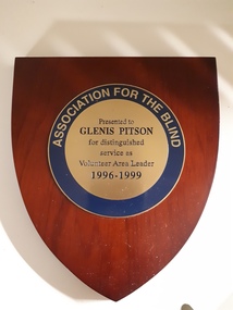 Vision Australia
Photograph - Image, Association for the Blind : Volunteer Area Leader
To celebrate the work undertaken by various members, the Association for the Blind presented wooden shields as mark of recognition and respect. Glenis Pitson 1996-1999 John Lodge 1997-1998Wooden shield with engraved gold and blue coloured plateAssociation for the Blind Presented to .... for distinguished service as Volunteer Area Leader 19... - 19 ..association for the blind, volunteers, awards -
 Darebin Parklands Association
Darebin Parklands Wetlands August 1985, Darebin Parklands Association et al, 1985
Colour photograph This item and all other Darebin Parklands Association archival material is now held by State Library Victoria (Accession No: YMS 13746). Please contact State Library Victoria if access is required.Annotated on back [Wetlands near BBQ area. Brad Hales Aug '85] -
 Darebin Parklands Association
Darebin Parklands BBQ area August 1985, Darebin Parklands Association et al, 1985
Colour photograph. This item and all other Darebin Parklands Association archival material is now held by State Library Victoria (Accession No: YMS 13746). Please contact State Library Victoria if access is required.Annotated on back [View from BBQ area. Brad Haler Aug '85] -
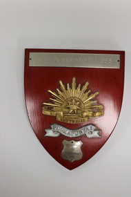 National Vietnam Veterans Museum (NVVM)
Plaque - Presented plaque
One of several items donated in memory of Sergeant Trevor J Nicholson, who served in Royal Australian Armoured Corps, C Squadron and B Squadron 1st Armoured Regiment, 1969-70, Vietnam.Wooden plaque with gold, rising and and dedication to SGT T Nicholson in 1977.Area Sergeants Mess/Australia/Puckapunyal/Presented/To/SGT t Nicholson/1977sgt t nicholson, puckapunyal, trevor nicholson, 1st armoured, nicholson, shield -
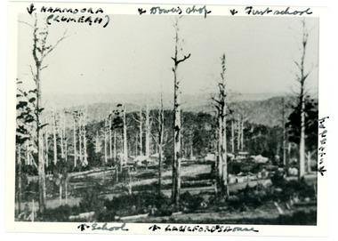 Mt Dandenong & District Historical Society Inc.
Photograph
Iconic photograph taken by Edgar Dower on Ridge Road in 1913 from an area known as Point Clear that shows the buildings of early Mt Dandenong before the CRB road went through in the 1920s.Black and white photograph with tall, dead trees in foreground and a view of hills in the distance. Buildings can be seen across the centre of the photograph. There are handwritten annotations around the border with arrows referring to areas in the photograph. Reverse of photograph has handwritten description by John Lundy-Clarke.Front from top left: Namoora (Lumeah), Dower's Shop, First school, Talent's, Langford's house, School. Reverse: 1913 view from O'Halloran's LOT 4, Section 3 on Ridge Road. Showing Lumeah (Namoora) Farndons Road (fence) School, Lowes House?, Falls Road Shop (Dowers) Langford's Falls Road (LOT 9, Section 1) Shed on Colomb's LOT 19, Sect 2 Colomb's House (Fergusons) First school Campbell's Blythes Road Lil Badenhop's P.O. In middle distance - Talent's homestead and sheds.point clear, namoora, lumeah, langford, dower, talent, colomb, ferguson, campbell, farndons road, mt dandenong school -
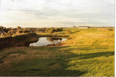
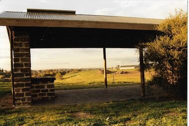
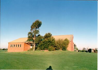 Hume City Civic Collection
Photograph, early 1980s
The series of photographs were taken shortly after the opening of the newly established Goonawarra Golf Club in the early 1980s. The golf club was part of the Goonawarra Housing Estate which was developed on the area previously known as Goonawarra Farm. The new golf club replaced 'The Pines' which was part of the Caloola complex.A coloured photograph of the rear of Goonawarra Golf Club's Clubrooms. Along the wall of a small vestibule are 6 narrow casement windows. A native garden is planted along the building with a large grassy area extending downhill from the building.goona warra golf club, george evans collection