Showing 1059 items matching "boundaries"
-
 Federation University Historical Collection
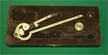
Equipment - Mathematical Instrument, Polar Planimeter, c1900s
Made for Kilpatrick & Co, Melbourne and used at Ballarat School of Mines. This mathematical instrument allowed users to determine the area of a curved region tracing its boundary. Two arms - one arm anchored at the end away from the pivot and one arm traced the drawing. The graph produced polar co-ordinates.A polar planimeter, housed in a storage box with molded, velvet lined interior. Hinged lid with clasp. Black fabric outside cover.Swiss made for Kilpatrik & Co. Melbourne Serial No. 62712 Paper sticker on underside of box "Made in Switzerland"planimeter, kilpatrick & co., polar planimeter, ballarat school of mines, mathematical instrument, area, curved region -
 City of Moorabbin Historical Society (Operating the Box Cottage Museum)
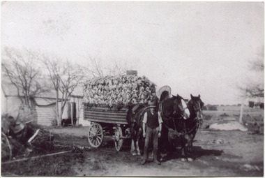
Photograph, Black & White, V Peterson East Boundary Rd East Bentleigh loaded wagon c1900, original c1900
The Peterson family were early settlers in Moorabbin Shire and established a market garden in East Boundary Road East Bentleigh. Vic Peterson and family loaded the crop - cabbages - onto the horse drawn wagon and set off to the Melbourne market using the Plateways that ran along Centre Road and Nepean Highway. The early settlers like the Petersons , in the Parish of Moorabbin County of Bourke after Henry Dendy's Special Survey Brighton 1841, established market gardens, fruit & flower gardens, poultry & dairy farms, vineyards as well as shop businesses, blacksmiths, chemists, nursing homes and schools & Churches.Black & White photograph showing Vic Peterson beside the horse drawn wagon loaded with 35dozen ( 12x 35) cabbages setting off to market c 1900 Original re-digitised by H Stanley 2005Back Hand written informationwagons, vulcan trucks, draught horses,, peterson vic, marriott dick, cabbage crops, vegetable crops, poliomyelitis epidemics 20thc , elster creek, plateways moorabbin shire, smith j l; smith mary ann, stanley helen, smith vic, smith harry redvers, chaff cutter, horse drawn carts, toll gates brighton, motor cars 1900, steam engines, early settlers, bentleigh, mckinnon, parish of moorabbin, city of moorabbin, county of bourke, moorabbin roads board, shire of moorabbin, henry dendy's special survey 1841, were j.b.; bent thomas, o'shannassy john, king richard, charman stephen, highett william, ormond francis, maynard dennis, market gardeners, vineyards, orchards -
 Melbourne Tram Museum
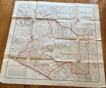
Map, Department of Lands and Survey Melbourne, Commonwealth Electoral Division of Fawkner, 1-10-1912
Shows a detailed street plan of South Melbourne, Albert Park, Prahran, South Yarra and parts of Melbourne in 1912. Used to mark the electoral boundaries of the Commonwealth Electoral Division of Fawkner. Shows all the then cable tram lines, rail lines and the electric line of the PMTT along with docks, gardens and significant buildings.Gives details of the Fawkner Electoral district in 1912.Folded sheet - Map - Commonwealth Electoral Division of Fawkner - two colours showing the subdivisions and polling placesmelbourne, fawkner, tram lines, cable trams, maps, electoral maps, south melbourne, albert park, prahran -
 Glen Eira Historical Society
Document - Laundries
Newspaper cutting of workers at the Economy Laundry in Elsternwick, 1938, source unknown, taken by Harold Paynting. Typed recollections by Felicity Campbell dated 02/04/2007 and further research by Claire Barton from SANDS AND MCDOUGAL’S 1942 edition, dated 02/07/2013, noting other boundaries in Caulfield municipality.elsternwick, economy laundry, point nepean road, presbyterian church, orphanages, regent lodge, st john’s presbyterian church, glen huntly road, foster street, campbell family, bristol, carnegie, collis m mrs, glen eira road, cutland e mrs, 'kennington', riddell parade, 'kooyong', 'primrose', martin street, wadekin a mrs, murrumbeena road, murrumbeena, 'waverly', hawthorn road, caulfield north, paynting harold, rosstown road, gardenvale road, glen eira road, caulfield, elsternwick girls' home, regent street, presbyterian womens mission union, recipe books -
 Sunbury Family History and Heritage Society Inc.
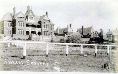
Photograph, Asylum Sunbury
The administrative building along with four other buildings were part of the former Sunbury Asylum complex that operated in Sunbury on Jacksons Hill from 1876 to 1992. The white fence in the front of the photo was the boundary for The Pines golf club where patients, staff and Sunbury residents played before the Goonawarra Golf Club was established.The Sunbury Asylum was an important institution in the town and many of the townspeople worked there over the 120 years of its operation.A non-digital sepia photograph in post card format with a white border across the bottom, of the administrative building and other brick Victorian style buildings that were part of the Sunbury Asylum complex. A white post and rail fence is in the foreground. sunbury asylum, caloola, the pines golf club -
 Kiewa Valley Historical Society
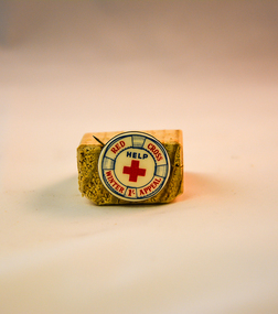
Badge Red Cross, circa 1968
When this winter appeal badge was produced the Australian economy was in recession (financial down turn) and the ability of some of the unemployed sectors of the community required but could not purchase warm clothes. The Australian recessions of 1945 and 1961 left their mark on the economy and accounted for a long and slow recovery in the 1960's and 1970's. The Red Cross was one of a few benevolent agencies/organisations that provided those more affluent in society to donate money to these types of appeals for financial donations. the money collected was used in obtaining warm close for those in need.In the Kiewa Valley the lingering recessional consequences (high interest rates, slowdown in Australian manufacturing) had an effect upon those whose produce was consumed by large towns and cities. The manufacturing industries including textile and clothing industries were feeling the start of the invasion of cheaper imports. Unemployment was beginning to be an ongoing major political and social issue. The need for support for the financial strapped city and country towns was on the increase and this Red Cross Badge (Winter Appeal) was one of several appeals to help those financially disenfranchised families to overcome the severe clothing shortages in both country and city environments.This badge has an enamel front with red and blue lettering and the circumference is marked to represent a 'life ring, life buoy, life belt' which has all of the red lettering with in its boundary. The fastening mechanism is a "stick" pin made from mild steel (fashioned as a semi circular spring contained within the back rim of the badge. The "stick" protrudes beyond the badge allowing it to be fastened onto clothing.At the top of the badge and in red print "RED CROSS" and at the bottom "WINTER APPEAL" with a"1/-" (one shilling coin - modern equivalent to 10 cents). In the middle of the badge is printed a red cross and above that "HELP"societies, red cross appeals, apparel badges, numismatics badges -
 Bendigo Historical Society Inc.
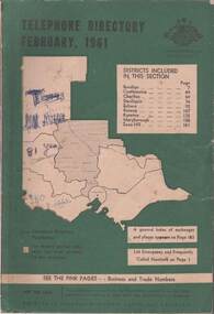
Book - TELEPHONE DIRECTORY FEBRUARY 1961, February 1961
Soft covered Telephone Directory February 1961. Districts covered are Bendigo, Castlemaine, Charlton, Deniliquin, Echuca, Kerang, Kyneton, Maryborough, Swan Hill. Cover has a green background with an outline of the map of Victoria in white. The Victorian Telephone directory boundaries are indicated and the district covered is shaded with black dots. Some handwritten jottings are written in ink on the cover. The directory contains both white and pink pages.book, bendigo, bendigo history & its people -
 Ballarat Tramway Museum
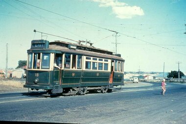
Slide - 35mm slide/s, mid 1950's
Yields information about the Geelong tramway system and one of the terminus and the appearance at the time.Agfachrome Professional plastic mount (blue base, white cover) reproduction slide of a colour slide of Geelong Pengelley No. 18 at East Terminus Ormond and Boundary Roads. Photo shows a child walking away from the tram. Tram has the destination of East. Photographer unknown. Taken on the last day of the first closures, 8/1/1956. See also Reg Item 4389 for a print of this slide. "G 16" and "1 -16" in pencil.tramways, trams, geelong, east, closure, last day, tram 18 -
 Melbourne Tram Museum
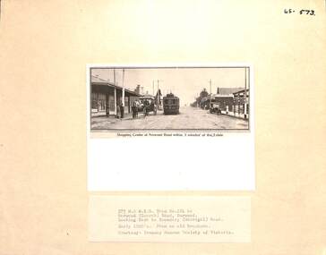
Photograph - Block Mounted Photograph, Surrey Hill Neighbourhood Centre, c1920
Photograph - mounted onto a heavy card, numbered 65-573 in the top right hand corner of MTTB No. 124 at the Burwood Road, or Norwood terminus in Toorak Road, at Boundary Road. Copied from a Real Estate brochure. Photo courtesy of the TMSV. Photo shows a number of shops or stores, including a Tea Merchant and the single line tramway on the south side of the roadway. See image i2 for a scan of the photograph.On rear in ink "Copied for Keith Kings 2002: and the "Surrey Hill Neighbourhood Centre" stamp.trams, tramways, burwood, toorak road, tram 124 -
 Bendigo Historical Society Inc.
Map - COMET MINE - LONGITUDINAL SECTION COMET MINE
Longitudinal section of the Comet Mine on the Hustler's Line of Reef Bulletin No 33, Plate No XXVI signed by H. S. Whitelaw, Underground Survey Office Bendigo, September 1913. Map shows datum lines, depths of levels, approximate boundaries and references to other plans. Note - Plates 4, 8, 13, 20, 26 and 31 form a Longitudinal Section from Fortuna Hustler's to Hustler's Consols Mine. Geological Survey of Victoriamining, parish map, hustler's line of reef, longitudinal section of comet mine bulletin no 33 plate no xxvi, h s whitelaw -
 Bendigo Historical Society Inc.
Map - UNITED HUSTLER'S & REDAN & K. K. MINES - PLAN OF UNITED HUSTLER'S & REDAN & K. K. MINES
Plan of the United Hustler's & Redan & K. K. Mines on the Hustler's Line of Reefs Bulletin No 33 Plate No XXVII. Plan shows depth of levels, Long Gully, Hustler's Line of Reefs, Lightning Hill Line of Reefs and approximate Boundary of Lease. Also mentions Comet Co. Geological Survey of Victoria emblem and signed by H S Whitelaw, Underground Survey Office Bendigo September 1913.mining, parish map, united hustler's & redan & k. k. mines, long gully, hustler's line of reefs, lightning hill line of reefs, comet co, h s whitelaw, geological survey of victoria, underground survey office -
 Eltham District Historical Society Inc
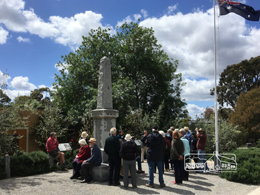
Photograph, Peter Pidgeon, Eltham War Memorial, 903-907 Main Road, Eltham, 4 November 2017, 4 Nov 2017
Eltham District Historical Society heritage walk to follow the boundaries of the original Shillinglaw Farm in central Eltham, held Saturday, 4th November, 2017. The Shillinglaw Farm comprised Lot 90 of Holloway’s 1851 Little Eltham subdivision. It was originally 30 acres in area and situated east of the Diamond Creek and north of Henry Street.Born digital imageeltham war memorial, obelisk, war memorial buidings, war memorial hall -
 Eltham District Historical Society Inc
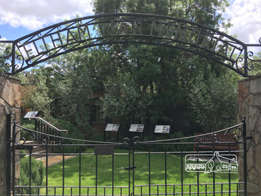
Photograph, Peter Pidgeon, Eltham War Memorial, 903-907 Main Road, Eltham, 4 November 2017, 4 Nov 2017
Eltham District Historical Society heritage walk to follow the boundaries of the original Shillinglaw Farm in central Eltham, held Saturday, 4th November, 2017. The Shillinglaw Farm comprised Lot 90 of Holloway’s 1851 Little Eltham subdivision. It was originally 30 acres in area and situated east of the Diamond Creek and north of Henry Street.Born digital imagecr. e.j. andrew, eltham war memorial, ernie andrew, war memorial buidings, war memorial garden, war memorial gates -
 Eltham District Historical Society Inc
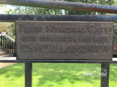
Photograph, Peter Pidgeon, Eltham War Memorial, 903-907 Main Road, Eltham, 4 November 2017, 4 Nov 2017
Eltham District Historical Society heritage walk to follow the boundaries of the original Shillinglaw Farm in central Eltham, held Saturday, 4th November, 2017. The Shillinglaw Farm comprised Lot 90 of Holloway’s 1851 Little Eltham subdivision. It was originally 30 acres in area and situated east of the Diamond Creek and north of Henry Street.Born digital imagecr. e.j. andrew, eltham war memorial, ernie andrew, war memorial buidings, war memorial garden, war memorial gates -
 Greensborough Historical Society
Book, Nillumbik Shire Council, 1997 Community Guide Nillumbik, 1997_
Guide to services provided by Nillumbik Shire Council. Nillumbik Shire is located 25 kilometres north-east of Melbourne and the southern boundary is the Yarra River. The south of Nillumbik is predominantly urban, with commercial centres at Eltham and Diamond Creek. The north of the municipality includes significant natural features like Kinglake National Park and Sugarloaf ReservoirAnnual guide to services in Nillumbik. 64 pages. Cover is pale yellow with colour drawings. nillumbik shire council, handbooks -
 Greensborough Historical Society
Book, Nillumbik Shire Council, 1998 Community Guide Nillumbik, 1998_
Guide to services provided by Nillumbik Shire Council. Nillumbik Shire is located 25 kilometres north-east of Melbourne and the southern boundary is the Yarra River. The south of Nillumbik is predominantly urban, with commercial centres at Eltham and Diamond Creek. The north of the municipality includes significant natural features like Kinglake National Park and Sugarloaf ReservoirAnnual guide to services in Nillumbik 72 pages. Cover has white background and some 3-D artwork.nillumbik shire council, handbooks -
 Greensborough Historical Society
Book, Nillumbik Shire Council, 1999 Community Guide Nillumbik, 1999_
Guide to services provided by Nillumbik Shire Council. Nillumbik Shire is located 25 kilometres north-east of Melbourne and the southern boundary is the Yarra River. The south of Nillumbik is predominantly urban, with commercial centres at Eltham and Diamond Creek. The north of the municipality includes significant natural features like Kinglake National Park and Sugarloaf ReservoirAnnual guide to services in Nillumbik76 pages, illus. Cover has photographs of local people and title in white on orange background.nillumbik shire council, handbooks -
 Greensborough Historical Society
Book, Nillumbik Shire Council, Nillumbik Community Guide 2000/2001, 2000-2001
Guide to services provided by Nillumbik Shire Council. Nillumbik Shire is located 25 kilometres north-east of Melbourne and the southern boundary is the Yarra River. The south of Nillumbik is predominantly urban, with commercial centres at Eltham and Diamond Creek. The north of the municipality includes significant natural features like Kinglake National Park and Sugarloaf ReservoirAnnual guide to services in Nillumbik76 pages, black and white illustrations. Cover has a collage of local children with title in white on mid-blue background.nillumbik shire council, handbooks -
 Eltham District Historical Society Inc
Book, Melway Publishing, Melway Greater Melbourne street directory : including Geelong, Phillip Island, Healesville, Bellarine & Mornington Peninsulas, 2002
Edition 29. Coloured detailed maps accessed by a street or location index. Cover: 20 additional pages of new maps, extended coverage of Bellarine Peninsula, further coverage of Werribee South, Public Transport Information, latest official suburb boundaries, CBD "hook turn" intersections map, over 1200 new streets, 1 atlas (24, 886 p.) : col. maps ; ISSN 03113957streets, roads, melbourne, maps, melway -
 Department of Energy, Environment and Climate Action
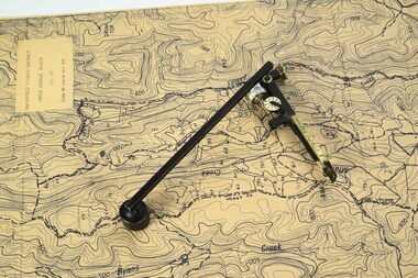
Planimeter (fixed arm)
The heavy weight is pinned onto the map and the tracing arm is used to follow the boundary to be measured Reading the number of revolutions from the two the scale wheels the area in square inches could be measured. Knowing the scale of the mapsheet the figure was converted to areas or hectares Generally at least three measurements were taken to ensure accuracy and precisionPlanimeter used to measure areas from scale maps. Includes wooden box One revolution of the main wheel equaled 10 square inches. A smaller rotating scale on the side was used to subdivide the area.Benallaforests commission victoria (fcv), forest measurement, surveying -
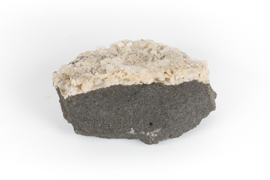 The Beechworth Burke Museum
Geological specimen - Hyalite in Basalt
According to the 1912 Department of Mines Bulletin of the Geological Survey of Victoria, basalt covers a considerable portion of the Macedon area including Mount Macedon. Basalt is the most common form of rock underlying the earth's surface and is found in three kinds of rock forming environments: ocean divergent boundaries, oceanic hotspots, and mantle plumes and hotspots beneath continents.This specimen is part of a larger collection of geological and mineral specimens collected from around Australia (and some parts of the world) and donated to the Burke Museum between 1868-1880. A large percentage of these specimens were collected in Victoria as part of the Geological Survey of Victoria that begun in 1852 (in response to the Gold Rush) to study and map the geology of Victoria. Collecting geological specimens was an important part of mapping and understanding the scientific makeup of the earth. Many of these specimens were sent to research and collecting organisations across Australia, including the Burke Museum, to educate and encourage further study.A solid mass, geological specimen in shades of grey and white. Hyalite is a colourless variety of opal. It occurs as globular and botryoidal masses and irregular crusts in volcanic and pegmatite environments where the silica deposits from the gas phase. Basalt is dark in colour, fine-grained igneous rock composed of plagioclase and pyroxene minerals. It is commonly formed as an extrusive rock, such as lava flow. It is one of the most common forms of rock underlying the earth's surface.burke museum, geological specimen, department of mines, geological survey of victoria, basalt, mount macedon, beechworth -
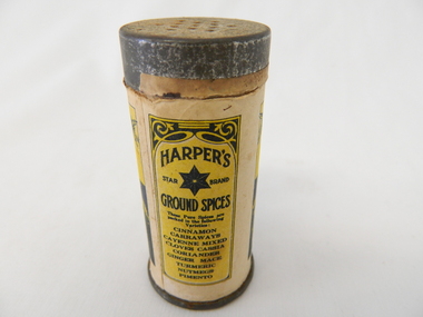 Kiewa Valley Historical Society
Shaker Spices, after 1895
This item was used at a time when there was a limited range of spices available and sought after by domestic and commercial kitchens. The taste buds of the average Australian diner were limited to the basic English style dishes which had been delivered by the early colonial days. Rural areas where slower in experimenting with Asian and European cuisine. The influx of European cuisine from refugees fleeing both World War I and world War II brought a different appreciation of gourmet food. The increase in Asian spices was brought about by Australians becoming more aware of the Asian "scene" through the conflicts of Korean and Vietnam military action. The "standard" type spices such as Cinnamon, nutmeg and similar spices offered by Robert Harper and later other Food and Spices whole sellers and processors where a direct result of a greater influx of migrants from spices rich societies and resulted in a greater range of "Asian" spices This became more visible after demise of the "White Australian Policy" on immigration and the great media revolution of Televised cooking shows from the 1950s on. The sustainability of containers such as this re-useable tin and cardboard spice holder, which could be replenished and not thrown away after it was empty was it a time period well before the "throw away" society had crept into the Valley.This spice container was used mainly in domestic kitchen within the Kiewa Valley. Those European construction workers of the SEC Kiewa Hydro Electricity Scheme had brought their continental cuisine into the valley and that was the beginning of a new era in highlighting different tastes. This rural valley had a greater interaction with people from other nation's cuisines and by association became more infused with a broader range of spices and food preparations.This item (spice shaker) is constructed by using a thick cardboard cylinder with both ends closed by tin plated light steel lids. The bottom lid is not removable however the top lid is removable to allow the contents (Cinnamon Spice) to be refilled. The lid has thirteen small holes which allow the contents to be shaken out. The outer side of the cylinder has been covered (glued on) by a printed black and yellow label detailing contents , weight, and supplier.On the front side of the printed label outside of the label boundary is "To make a shaker of this tin - take the lid off and remove the paper from inside the lid" Within the marked horse shoe shaped boundary is" HARPER'S ground spices star brand" underneath "CINNAMON" underneath this is printed "1 oz. NET WEIGHT" and under this, within its own frame " ROBERT HARPER COMPANY LIMITED (incorporated in Victoria) AUSTRALIA." On the back within its own box is "HARPER'S star brand GROUND SPICES" and underneath "These Pure Spices are packed in the following Varieties". Below this is a list (going down) "CINNAMON CARRAWAYS CAYENNE MIXED CLOVES CASSIA CORIANDER GINGER MACE TURMERIC NUTMEGS PIMENTO"kitchen spices, spice shakers, food preparation -
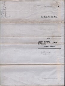 Bendigo Historical Society Inc.
Document - MCCOLL, RANKIN AND STANISTREET COLLECTION: CENTRAL NAPOLEON GOLD MINING CO. N.L, 3rd November 1943
Document: Letter sent to Central Napoleon Gold Mining Co from McColl Rankin and Stanistreet regarding Mr Daniel Keane's application for a grazing licence over a block of crown land within the boundaries of the Company's Lease No 10260, this letter is enquiring whether or not the company has any objections to granting Mr Keane's application, the area concerned is marked in grey lead pencil on the map attached to the lease numbered 2205.704a.organization, business, industry - mining, mccoll rankin & stanistreet, mining, gold mining, grazing application, central napoleon, daniel keane -
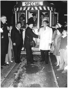 Ballarat Tramway Museum
Photograph - Black & White Photograph/s set of 2, Harvey Studios, 19/09/1971 12:00:00 AM
Yields information about the closure of the SEC operated Ballarat tram system and the people involved.Set of two photographs of the last tram leaving the Borough of Sebastopol where the tram keys were handed over to to Cr. J. Chisholm , at the town boundary. Cr. N. Donald, Mr. L. J. Denmead (behind Lew Walker), L. Walker, Cr. Walker, Mrs. Chisholm and Mrs Donald. Photo taken 19/9/1971. For The Courier newspaper photographs of the event see Reg Item 3335.On rear is the Photography stamp - "N.L. Harvey & Son - Photographers - 131 Sturt St, Ballarat" with phone numbertrams, tramways, closure, sebastopol, last tram, city of ballaarat, borough of sebastopol, closure, tram 40 -
 Kew Historical Society Inc
Article, The New Electric Tramway, Malvern to Kew
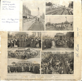
One of a group of photographs, including three within a published photo collage , taken by Edgar James Dower in the second decade of the twentieth century. Born and raised in Olinda, Dower later moved to Surrey Hills. He worked as an adult as a clerk in the city office of the Metropolitan Gas Company, and in his role as a 'collector', he was able to photograph scenes including the construction of tramlines, railways and associated buildings in Kew, Hawthorn, Camberwell and Surrey Hills. Later he established a real estate agency with his brother - the E.J. Dower Real Estate Agency, Mount Dandenong Office.The photo collage is an historically significant record of the development of transport infrastructure which was used to connect Victorians in the first two decades of the twentieth century. This development resulted from increases in population and the consequent extension of Melbourne's suburbs. The photographs, both individually and collectively, richly detail the labour of workers and the tools and machinery used to create and extend Melbourne's public transport network in the years preceding and during World War 1.Photo collage, published in The Leader newspaper in 1913, to commemorate the opening of the Malvern to Kew Tramway. The numbered photos are: 1. Kew Railway Gates at Glenferrie. 2. Burke Road Terminus. 3. Final Stages. 4. Ladies at the Official Opening. 5. The Acting Mayoress of Kew Cutting the Ribbon at the Kew Boundary. 6. Mayor and Councillors at the Kew Terminus. 7. The Cutting the First Ribbon. 8. Guests at the Hawthorn Town Hall.Inscribed in ink by Edgar J Dower top left: "The 3 top photographs were taken by E J Dower. No.3 Cotham Road Kew near Glenferrie Road"theme -- connecting victorians by transport and communications, theme -- travelling by tram -
 Bendigo Historical Society Inc.
Map - HUSTLER'S ROYAL RESERVE NO 2 MINE - PLAN OF THE HUSTLER'S ROYAL RESERVE NO 2 MINE
Plan of the Hustler's Royal Reserve No 2 Mine on the Hustler's Line of Reefs Bulletin No 33, Plate No VI. Boundary of Leases No 8898 and 8897 shown. Various levels shown and some geographical features. Geological Survey of Victoria emblem. H . Harman, Director, W. Dickson, Secretary for Mines and The Hon. J. Drysdale Brown, Minister of Mines and signed by H Whitdon, Underground Survey Office, Bendigo, September 1913. mining, parish map, hustler's royal reserve no 2 mine, hustler's line of reefs, geological survey of victoria, h herman, w dickson, the hon j drysdale brown mlc -
 Melbourne Tram Museum
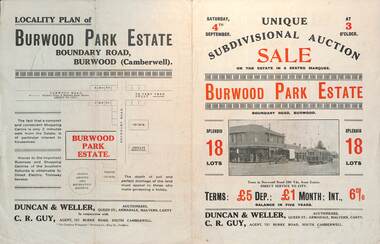
Ephemera - Real estate sale, Duncan & Weller Auctioneers, "Burwood Park Estate" Boundary Road, 1926
Pamphlet advertising the sale of land at the Burwood Park Estate, Boundary Road Burwood, Saturday 4th September. Does not give the year, most likely 1926. Promotes the tram service, nearby shops, the suitability of the soil for gardening and other facilities. Has a photo of possibly W 259 at the terminus. The plan of sub-division shows 18 lots for sale.Demonstrates the style of land sale pamphlet including the availability of tram services to prospective purchasers.Pamphlet - folded - printed in two colours of cream coloured paper with photographs and plans.sale of land, trams, real estate, burwood park, burwood -
 Warrnambool and District Historical Society Inc.
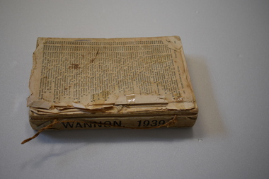
Book - Electoral Roll - Wannon, Electoral Roll
This book contains the names of those on the 1939 electoral roll for Wannon in Victoria. It is an original Federal electorate and was established in 1901. It has had some changes of boundaries over the years. The sub-divisions in the Wannon electorate in 1939 included Branxholme, Casterton, Dimboola, Hamilton, Harrow, Horsham, Horsham South, Jeparit, Koroit, Nhill, Port Fairy, Portland, Stawell and Warrnambool. This book, although tattered and incomplete is a useful one as it has the names of all those on the electoral roll in the Wannon electorate in 1939 and this includes the Warrnambool area. It will be useful to researchers.This is a book containing printed material. It has no cover and is missing several front and back pages. One page at the back is loose and the pages are dog-eared. The book is bound with string. warrnambool 1939, electoral rolls -
 Kew Historical Society Inc
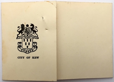
Document - Invitation, Invitation to Meet Mr Menzies and Dame Pattie Menzies, City of Kew, 1955, 1955
Robert (later Sir Robert) Menzies was the member for Kooyong from 1934 to 66, and Australian Prime Minister from 1939 to 41, and again from 1949 to 66. The City of Kew was within the boundaries of his electorate. Civic events, before the opening of the new Kew City Hall in 1960 were frequently held at the Kew Recreation Hall (demolished 1960) in Wellington Street.The Arthur Dear Collection is a comprehensive collection of theatrical ephemera relating to performances by theatrical and musical organisations from within and outside the former City of Kew who typically performed at venues in Kew during the 1950s and 1960s.Card formally acknowledging the acceptance of an invitation to an event in the Kew Recreation Hall. The printed response was issued by the Town Clerk - W.D. Birrell - on behalf of the Mayor - Cr. Marie Dalley. The event was held to meet Mr Menzies and Dame Pattie Menzies.arthur dear collection, robert menzies, dame pattie menzies, kew recreation hall, city of kew - invitations -
 Kew Historical Society Inc
Photograph - High Street, Kew, 1960-65
The borders of the main components of Kew and Kew East have not always conformed to current boundaries. In the past this photograph has been labelled as East Kew, whereas for most of the twentieth century the site has been within Kew's borders. The purpose of the photograph is unrecorded yet it has value in that it shows those businesses who occupied this site in Kew during the early 1960s.This small photograph is significant as it shows the location of and building used by WD Vaughan, former Mayor of Kew who was a successful newspaper proprietor in Melbourne.Small polaroid colour positive of High Street in Kew, probably in the 1960s. From left we can see the brick viaduct covering the tracks of what was once the Outer Circle Railway. Behind this brick wall, Dunnings Timber Yard was situated. At the end of the walls of the viaduct there is an entrance to a walkway [now the Anniversary Trail], which once provided access to Windsor Avenue, and also to the East Kew Station (now demolished and part of the Outer Circle Railway Reserve). On the other side of this walkway is a cream brick building (demolished) occupied at this time by WD Vaughan Pty Ltd, printer and publisher of the Kew Advertiser (newspaper). Stretching behind the brick facade is an extensive building that must have housed the printing works. Beside Vaughan's, there is a large building (demolished) housing at that time an estate agent named AJ Kennedy. This area is now separated by kerbing.High St East Kew / Corner of Harp Rd. / Looking South