Showing 574 items matching "castle"
-
 Ballarat Heritage Services
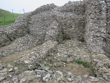
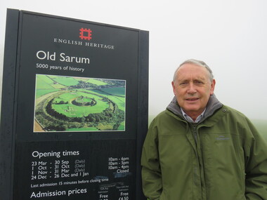
Photograph - Colour, Stonework, Old Sarum, England, English Heritage Site, 2016, 01 November 2016
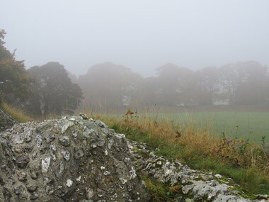
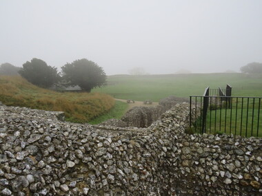
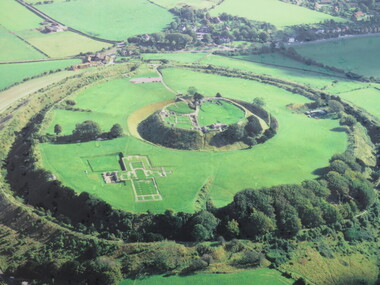
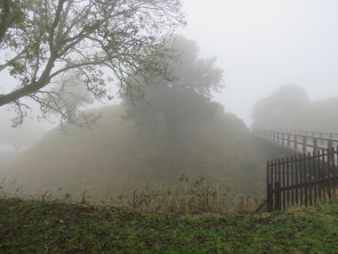
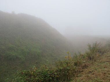
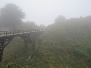
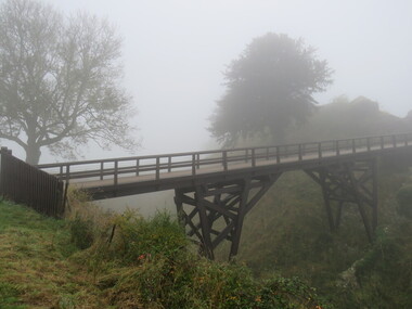
... It was an ideal site for a royal castle. It was here in 1070 that William paid off his army after a long and bitter campaign in northern England. ...It was an ideal site for a royal castle. It was here in 1070 that William paid off his army after a long and bitter campaign in northern England. ...William the Conqueror inherited Old Sarum from the last Saxon king of England. It was an ideal site for a royal castle. It was here in 1070 that William paid off his army after a long and bitter campaign in northern England. It was here in 1086 that he called together all the major landholders in England so they could swear allegiance to him. It was a crucial moment. The Domesday Book was being written, a threatened Viking invasion had only just been averted and William's eldest son was in armed rebellion. Old Sarum was an important place where this Norman king of England held power. In 1794 the Ordnance Survey set out to check the accuracy of the first mapping of Southern England, which had begun ten years earlier. From a point just below Old Sarum Lieutenant William Mudge laid out a base-line 36,574 feet (11,253 metres) long. From each end of the line the positions of distant places were plotted using a huge theodolite made in 1791 by Jesse Ramsden. The accuracy of the process, which was repeated all over England, depended on Jesse Ramsden's craftsmanship and on William Mudge's surveying skill in setting out this first base-line from Old Sarum. The nearer end of Mudge's line is marked by an inscribed stone beside the modern A345 at Old Sarum. ordnance survey, william mudge, jesse ramsden, william the conqueror, old sarum, saxon, 1086, england -
 Ballarat Heritage Services
Photograph - Colour, Stonework, Old Sarum, England, English Heritage Site, 2016, 01 November 2016
... It was an ideal site for a royal castle. It was here in 1070 that William paid off his army after a long and bitter campaign in northern England. ...It was an ideal site for a royal castle. It was here in 1070 that William paid off his army after a long and bitter campaign in northern England. ...William the Conqueror inherited Old Sarum from the last Saxon king of England. It was an ideal site for a royal castle. It was here in 1070 that William paid off his army after a long and bitter campaign in northern England. It was here in 1086 that he called together all the major landholders in England so they could swear allegiance to him. It was a crucial moment. The Domesday Book was being written, a threatened Viking invasion had only just been averted and William's eldest son was in armed rebellion. Old Sarum was an important place where this Norman king of England held power. In 1794 the Ordnance Survey set out to check the accuracy of the first mapping of Southern England, which had begun ten years earlier. From a point just below Old Sarum Lieutenant William Mudge laid out a base-line 36,574 feet (11,253 metres) long. From each end of the line the positions of distant places were plotted using a huge theodolite made in 1791 by Jesse Ramsden. The accuracy of the process, which was repeated all over England, depended on Jesse Ramsden's craftsmanship and on William Mudge's surveying skill in setting out this first base-line from Old Sarum. The nearer end of Mudge's line is marked by an inscribed stone beside the modern A345 at Old Sarum. ordnance survey, william mudge, jesse ramsden, william the conqueror, old sarum, saxon, 1086, england -
 Ballarat Heritage Services
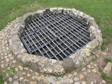
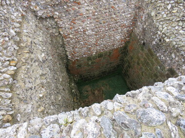
Photograph - Colour, Stonework and well, Old Sarum, England, English Heritage Site, 2016, 01 November 2016
... It was an ideal site for a royal castle. It was here in 1070 that William paid off his army after a long and bitter campaign in northern England. ...It was an ideal site for a royal castle. It was here in 1070 that William paid off his army after a long and bitter campaign in northern England. ...William the Conqueror inherited Old Sarum from the last Saxon king of England. It was an ideal site for a royal castle. It was here in 1070 that William paid off his army after a long and bitter campaign in northern England. It was here in 1086 that he called together all the major landholders in England so they could swear allegiance to him. It was a crucial moment. The Domesday Book was being written, a threatened Viking invasion had only just been averted and William's eldest son was in armed rebellion. Old Sarum was an important place where this Norman king of England held power. In 1794 the Ordnance Survey set out to check the accuracy of the first mapping of Southern England, which had begun ten years earlier. From a point just below Old Sarum Lieutenant William Mudge laid out a base-line 36,574 feet (11,253 metres) long. From each end of the line the positions of distant places were plotted using a huge theodolite made in 1791 by Jesse Ramsden. The accuracy of the process, which was repeated all over England, depended on Jesse Ramsden's craftsmanship and on William Mudge's surveying skill in setting out this first base-line from Old Sarum. The nearer end of Mudge's line is marked by an inscribed stone beside the modern A345 at Old Sarum. ordnance survey, william mudge, jesse ramsden, william the conqueror, old sarum, saxon, 1086, england -
 Ballarat Heritage Services
Photograph - Colour, Stonework, Old Sarum, England, English Heritage Site, 01 November 2016
... It was an ideal site for a royal castle. It was here in 1070 that William paid off his army after a long and bitter campaign in northern England. ...It was an ideal site for a royal castle. It was here in 1070 that William paid off his army after a long and bitter campaign in northern England. ...William the Conqueror inherited Old Sarum from the last Saxon king of England. It was an ideal site for a royal castle. It was here in 1070 that William paid off his army after a long and bitter campaign in northern England. It was here in 1086 that he called together all the major landholders in England so they could swear allegiance to him. It was a crucial moment. The Domesday Book was being written, a threatened Viking invasion had only just been averted and William's eldest son was in armed rebellion. Old Sarum was an important place where this Norman king of England held power. In 1794 the Ordnance Survey set out to check the accuracy of the first mapping of Southern England, which had begun ten years earlier. From a point just below Old Sarum Lieutenant William Mudge laid out a base-line 36,574 feet (11,253 metres) long. From each end of the line the positions of distant places were plotted using a huge theodolite made in 1791 by Jesse Ramsden. The accuracy of the process, which was repeated all over England, depended on Jesse Ramsden's craftsmanship and on William Mudge's surveying skill in setting out this first base-line from Old Sarum. The nearer end of Mudge's line is marked by an inscribed stone beside the modern A345 at Old Sarum. ordnance survey, william mudge, jesse ramsden, william the conqueror, old sarum, saxon, 1086, england -
 Ballarat Heritage Services
Photograph - Colour, Sign Explaining toilets, Old Sarum, England, English Heritage Site, 01/11/2016
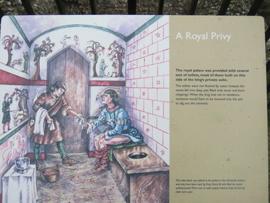
... It was an ideal site for a royal castle. It was here in 1070 that William paid off his army after a long and bitter campaign in northern England. ...It was an ideal site for a royal castle. It was here in 1070 that William paid off his army after a long and bitter campaign in northern England. ...William the Conqueror inherited Old Sarum from the last Saxon king of England. It was an ideal site for a royal castle. It was here in 1070 that William paid off his army after a long and bitter campaign in northern England. It was here in 1086 that he called together all the major landholders in England so they could swear allegiance to him. It was a crucial moment. The Domesday Book was being written, a threatened Viking invasion had only just been averted and William's eldest son was in armed rebellion. Old Sarum was an important place where this Norman king of England held power. In 1794 the Ordnance Survey set out to check the accuracy of the first mapping of Southern England, which had begun ten years earlier. From a point just below Old Sarum Lieutenant William Mudge laid out a base-line 36,574 feet (11,253 metres) long. From each end of the line the positions of distant places were plotted using a huge theodolite made in 1791 by Jesse Ramsden. The accuracy of the process, which was repeated all over England, depended on Jesse Ramsden's craftsmanship and on William Mudge's surveying skill in setting out this first base-line from Old Sarum. The nearer end of Mudge's line is marked by an inscribed stone beside the modern A345 at Old Sarum. Colour photograph of a sign explaining toilets at Old Sarum, English Heritage Siteordnance survey, william mudge, jesse ramsden, william the conqueror, old sarum, saxon, 1086,, england -
 Ballarat Heritage Services
Photograph - Colour, Toilets, Old Sarum, England, English Heritage Site, 2016, 01 November 2016
... It was an ideal site for a royal castle. It was here in 1070 that William paid off his army after a long and bitter campaign in northern England. ...It was an ideal site for a royal castle. It was here in 1070 that William paid off his army after a long and bitter campaign in northern England. ...William the Conqueror inherited Old Sarum from the last Saxon king of England. It was an ideal site for a royal castle. It was here in 1070 that William paid off his army after a long and bitter campaign in northern England. It was here in 1086 that he called together all the major landholders in England so they could swear allegiance to him. It was a crucial moment. The Domesday Book was being written, a threatened Viking invasion had only just been averted and William's eldest son was in armed rebellion. Old Sarum was an important place where this Norman king of England held power. In 1794 the Ordnance Survey set out to check the accuracy of the first mapping of Southern England, which had begun ten years earlier. From a point just below Old Sarum Lieutenant William Mudge laid out a base-line 36,574 feet (11,253 metres) long. From each end of the line the positions of distant places were plotted using a huge theodolite made in 1791 by Jesse Ramsden. The accuracy of the process, which was repeated all over England, depended on Jesse Ramsden's craftsmanship and on William Mudge's surveying skill in setting out this first base-line from Old Sarum. The nearer end of Mudge's line is marked by an inscribed stone beside the modern A345 at Old Sarum. ordnance survey, william mudge, jesse ramsden, william the conqueror, old sarum, saxon, 1086, england -
 Ballarat Heritage Services
Photograph - Colour, Stonework, Old Sarum, England, English Heritage Site, 2016, 01 November 2016
... It was an ideal site for a royal castle. It was here in 1070 that William paid off his army after a long and bitter campaign in northern England. ...It was an ideal site for a royal castle. It was here in 1070 that William paid off his army after a long and bitter campaign in northern England. ...William the Conqueror inherited Old Sarum from the last Saxon king of England. It was an ideal site for a royal castle. It was here in 1070 that William paid off his army after a long and bitter campaign in northern England. It was here in 1086 that he called together all the major landholders in England so they could swear allegiance to him. It was a crucial moment. The Domesday Book was being written, a threatened Viking invasion had only just been averted and William's eldest son was in armed rebellion. Old Sarum was an important place where this Norman king of England held power. In 1794 the Ordnance Survey set out to check the accuracy of the first mapping of Southern England, which had begun ten years earlier. From a point just below Old Sarum Lieutenant William Mudge laid out a base-line 36,574 feet (11,253 metres) long. From each end of the line the positions of distant places were plotted using a huge theodolite made in 1791 by Jesse Ramsden. The accuracy of the process, which was repeated all over England, depended on Jesse Ramsden's craftsmanship and on William Mudge's surveying skill in setting out this first base-line from Old Sarum. The nearer end of Mudge's line is marked by an inscribed stone beside the modern A345 at Old Sarum. ordnance survey, william mudge, jesse ramsden, william the conqueror, old sarum, saxon, 1086, england -
 Ballarat Heritage Services
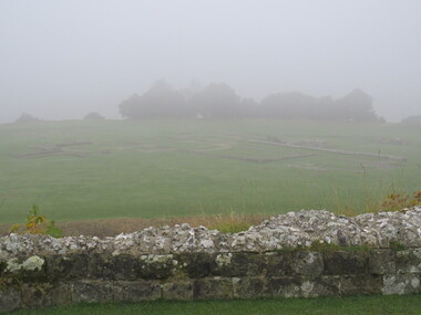
Photograph - Colour, Old Sarum, England, 2017, 01 November 2016
... It was an ideal site for a royal castle. It was here in 1070 that William paid off his army after a long and bitter campaign in northern England. ...It was an ideal site for a royal castle. It was here in 1070 that William paid off his army after a long and bitter campaign in northern England. ...William the Conqueror inherited Old Sarum from the last Saxon king of England. It was an ideal site for a royal castle. It was here in 1070 that William paid off his army after a long and bitter campaign in northern England. It was here in 1086 that he called together all the major landholders in England so they could swear allegiance to him. It was a crucial moment. The Domesday Book was being written, a threatened Viking invasion had only just been averted and William's eldest son was in armed rebellion. Old Sarum was an important place where this Norman king of England held power. In 1794 the Ordnance Survey set out to check the accuracy of the first mapping of Southern England, which had begun ten years earlier. From a point just below Old Sarum Lieutenant William Mudge laid out a base-line 36,574 feet (11,253 metres) long. From each end of the line the positions of distant places were plotted using a huge theodolite made in 1791 by Jesse Ramsden. The accuracy of the process, which was repeated all over England, depended on Jesse Ramsden's craftsmanship and on William Mudge's surveying skill in setting out this first base-line from Old Sarum. The nearer end of Mudge's line is marked by an inscribed stone beside the modern A345 at Old Sarum. ordnance survey, william mudge, jesse ramsden, william the conqueror, old sarum, saxon, 1086, england -
 Ballarat Heritage Services
Photograph - Photograph - Colour, Old Sarum, England, 2016, 01/11/2016
... It was an ideal site for a royal castle. It was here in 1070 that William paid off his army after a long and bitter campaign in northern England. ...It was an ideal site for a royal castle. It was here in 1070 that William paid off his army after a long and bitter campaign in northern England. ...William the Conqueror inherited Old Sarum from the last Saxon king of England. It was an ideal site for a royal castle. It was here in 1070 that William paid off his army after a long and bitter campaign in northern England. It was here in 1086 that he called together all the major landholders in England so they could swear allegiance to him. It was a crucial moment. The Domesday Book was being written, a threatened Viking invasion had only just been averted and William's eldest son was in armed rebellion. Old Sarum was an important place where this Norman king of England held power. In 1794 the Ordnance Survey set out to check the accuracy of the first mapping of Southern England, which had begun ten years earlier. From a point just below Old Sarum Lieutenant William Mudge laid out a base-line 36,574 feet (11,253 metres) long. From each end of the line the positions of distant places were plotted using a huge theodolite made in 1791 by Jesse Ramsden. The accuracy of the process, which was repeated all over England, depended on Jesse Ramsden's craftsmanship and on William Mudge's surveying skill in setting out this first base-line from Old Sarum. The nearer end of Mudge's line is marked by an inscribed stone beside the modern A345 at Old Sarum. Colour photograph of Old Sarum, England.ordnance survey, william mudge, jesse ramsden, william the conqueror, old sarum, saxon, 1086, england -
 Ballarat Heritage Services
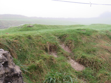
Photograph - Colour, Earth Banks, Old Sarum, England, 01 November 2016
... It was an ideal site for a royal castle. It was here in 1070 that William paid off his army after a long and bitter campaign in northern England. ...It was an ideal site for a royal castle. It was here in 1070 that William paid off his army after a long and bitter campaign in northern England. ...William the Conqueror inherited Old Sarum from the last Saxon king of England. It was an ideal site for a royal castle. It was here in 1070 that William paid off his army after a long and bitter campaign in northern England. It was here in 1086 that he called together all the major landholders in England so they could swear allegiance to him. It was a crucial moment. The Domesday Book was being written, a threatened Viking invasion had only just been averted and William's eldest son was in armed rebellion. Old Sarum was an important place where this Norman king of England held power. In 1794 the Ordnance Survey set out to check the accuracy of the first mapping of Southern England, which had begun ten years earlier. From a point just below Old Sarum Lieutenant William Mudge laid out a base-line 36,574 feet (11,253 metres) long. From each end of the line the positions of distant places were plotted using a huge theodolite made in 1791 by Jesse Ramsden. The accuracy of the process, which was repeated all over England, depended on Jesse Ramsden's craftsmanship and on William Mudge's surveying skill in setting out this first base-line from Old Sarum. The nearer end of Mudge's line is marked by an inscribed stone beside the modern A345 at Old Sarum. ordnance survey, william mudge, jesse ramsden, william the conqueror, old sarum, saxon, 1086, england -
 Ballarat Heritage Services
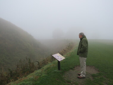
Photograph - Colour, Dorothy Wickham, Earth Banks, Old Sarum, England, 2016, 01 November 2016
... It was an ideal site for a royal castle. It was here in 1070 that William paid off his army after a long and bitter campaign in northern England. ...It was an ideal site for a royal castle. It was here in 1070 that William paid off his army after a long and bitter campaign in northern England. ...William the Conqueror inherited Old Sarum from the last Saxon king of England. It was an ideal site for a royal castle. It was here in 1070 that William paid off his army after a long and bitter campaign in northern England. It was here in 1086 that he called together all the major landholders in England so they could swear allegiance to him. It was a crucial moment. The Domesday Book was being written, a threatened Viking invasion had only just been averted and William's eldest son was in armed rebellion. Old Sarum was an important place where this Norman king of England held power. In 1794 the Ordnance Survey set out to check the accuracy of the first mapping of Southern England, which had begun ten years earlier. From a point just below Old Sarum Lieutenant William Mudge laid out a base-line 36,574 feet (11,253 metres) long. From each end of the line the positions of distant places were plotted using a huge theodolite made in 1791 by Jesse Ramsden. The accuracy of the process, which was repeated all over England, depended on Jesse Ramsden's craftsmanship and on William Mudge's surveying skill in setting out this first base-line from Old Sarum. The nearer end of Mudge's line is marked by an inscribed stone beside the modern A345 at Old Sarum. King William devised the Domesday Book, considered to be the first listing of land owners in England. Among the names is that of D'Arques, from Normandy, France. Descendants of this family later emigrated from England and settled in Victoria, Australia under the surname 'Dark'. ordnance survey, william mudge, jesse ramsden, william the conqueror, old sarum, saxon, 1086, england -
 Ballarat Heritage Services
Photograph - Colour, Earth Banks, Old Sarum, England, 2016, 01 November 2016
... It was an ideal site for a royal castle. It was here in 1070 that William paid off his army after a long and bitter campaign in northern England. ...It was an ideal site for a royal castle. It was here in 1070 that William paid off his army after a long and bitter campaign in northern England. ...William the Conqueror inherited Old Sarum from the last Saxon king of England. It was an ideal site for a royal castle. It was here in 1070 that William paid off his army after a long and bitter campaign in northern England. It was here in 1086 that he called together all the major landholders in England so they could swear allegiance to him. It was a crucial moment. The Domesday Book was being written, a threatened Viking invasion had only just been averted and William's eldest son was in armed rebellion. Old Sarum was an important place where this Norman king of England held power. In 1794 the Ordnance Survey set out to check the accuracy of the first mapping of Southern England, which had begun ten years earlier. From a point just below Old Sarum Lieutenant William Mudge laid out a base-line 36,574 feet (11,253 metres) long. From each end of the line the positions of distant places were plotted using a huge theodolite made in 1791 by Jesse Ramsden. The accuracy of the process, which was repeated all over England, depended on Jesse Ramsden's craftsmanship and on William Mudge's surveying skill in setting out this first base-line from Old Sarum. The nearer end of Mudge's line is marked by an inscribed stone beside the modern A345 at Old Sarum. ordnance survey, william mudge, jesse ramsden, william the conqueror, old sarum, saxon, 1086, england -
 Ballarat Heritage Services
Photograph - Colour, Earth Banks, Old Sarum, England, 2016, 01 November 2016
... It was an ideal site for a royal castle. It was here in 1070 that William paid off his army after a long and bitter campaign in northern England. ...It was an ideal site for a royal castle. It was here in 1070 that William paid off his army after a long and bitter campaign in northern England. ...William the Conqueror inherited Old Sarum from the last Saxon king of England. It was an ideal site for a royal castle. It was here in 1070 that William paid off his army after a long and bitter campaign in northern England. It was here in 1086 that he called together all the major landholders in England so they could swear allegiance to him. It was a crucial moment. The Domesday Book was being written, a threatened Viking invasion had only just been averted and William's eldest son was in armed rebellion. Old Sarum was an important place where this Norman king of England held power. In 1794 the Ordnance Survey set out to check the accuracy of the first mapping of Southern England, which had begun ten years earlier. From a point just below Old Sarum Lieutenant William Mudge laid out a base-line 36,574 feet (11,253 metres) long. From each end of the line the positions of distant places were plotted using a huge theodolite made in 1791 by Jesse Ramsden. The accuracy of the process, which was repeated all over England, depended on Jesse Ramsden's craftsmanship and on William Mudge's surveying skill in setting out this first base-line from Old Sarum. The nearer end of Mudge's line is marked by an inscribed stone beside the modern A345 at Old Sarum. ordnance survey, william mudge, jesse ramsden, william the conqueror, old sarum, saxon, 1086, england -
 Surrey Hills Historical Society Collection
Folder of information, John Hanlon Knipe and his family history
... This includes: . family tree of Knipe in Lancashire and London . birth, death and marriage certificates . family trees of members in Australia . story of Knipe's Castle in Bendigo (built by John Hanlon Knipe), also photos of the same, newspaper articles and correspondence regarding it . location of Knipe graves in Bendigo Cemetery . itinerary to places of interest re Knipe in Bendigo . record of J H Knipe in Prahran Council . ...Philip Slobom was a member of Kew Historical Society. knipe's castle knipe cup prahran council john hanlon knipe, philip slobom Blue folder of A4 size. ...John Hanlon Knipe is the person credited with first using the name 'Surrey Hills'. Not all of this material is of direct relevance to Surrey Hills, which in fact was but a small part of J H Knipe's business and land dealings. However it was decided that it was appropriate to keep the collection of material together. Philip Slobom was a member of Kew Historical Society. Blue folder of A4 size. The folder contains a comprehensive collection of material relating to the Knipe family, both in Australia and in Lancashire and London. This includes: . family tree of Knipe in Lancashire and London . birth, death and marriage certificates . family trees of members in Australia . story of Knipe's Castle in Bendigo (built by John Hanlon Knipe), also photos of the same, newspaper articles and correspondence regarding it . location of Knipe graves in Bendigo Cemetery . itinerary to places of interest re Knipe in Bendigo . record of J H Knipe in Prahran Council . John Crouch Knipe in South Australia (1873-1889) by Kevin Knipe . History of James Service, John Hanlon Knipe, their families and Roberta, Roderick & Muriel Knipe by Barbara Fraser . Barbara Fraser's comments at Philip Slobom's funeral (22/7/2015) . material regarding the Knipe Cup . photocopies of images (2) of J H Knipe . correspondence between Philip Slobom and various Knipe relatives . photocopies of various articles from The Telegraph (Prahran) concerning J H Knipe's time as a Prahran Councillor.knipe's castle, knipe cup, prahran council, john hanlon knipe, philip slobom -
 Bendigo Historical Society Inc.
Book - BENDIGO SALEYARDS COLLECTION: PIG AND CALF MARKET - DRAWN AND SOLD
... Names in the branding column are Highland Meats, Ralph, Daylesford, Gilby, CBC, and Castle. Listed are the number of Bobby Calves for each agent and the numbers of Fats and Stores and Total....Names in the branding column are Highland Meats, Ralph, Daylesford, Gilby, CBC, and Castle. Listed are the number of Bobby Calves for each agent and the numbers of Fats and Stores and Total. ...Pig and Calf Market, Numbers Drawn and Sold book with a grey and cream cover with a red tape spine. Book has pale blue pages. 'Pigs' written on the front of the book. Book dates from 4/1/1990 to 13/12/90. Agents names are written in the book in the order of draw for the weekly market. Agents are Nuttall, Nevins, Elders, McKean, McGregor, V.P.C., Dalgety. Names in the branding column are Daylesford, Ralph, Gilby, CBC 3, and Aus Pork. Listed are the number of Bobby Calves for each agent and the numbers of Fats and Stores and Total. Pig and Calf Market, Numbers Drawn and Sold book with a grey and cream cover with a red tape spine. Book has pale boue pages. Pigs written on the front of the book. Book dates from 3/1/91 to 12/12/91. Agents names are written in the book in the order of draw for the weekly market. Agents are Dalgety, McKean, Nuttall, McGregor, Nevins, U.P.C.. Names in the branding column are Highland Meats, Ralph, Daylesford, Gilby, CBC, and Castle. Listed are the number of Bobby Calves for each agent and the numbers of Fats and Stores and Total.bendigo, council, cattle markets, bendigo saleyards collection - pig and calf market - drawn and sold, nuttall, nevins, elders, mckean, mcgregor, vpc, dalgety, cbc, aus pork, ralph, daylesford, gilby -
 Bendigo Historical Society Inc.
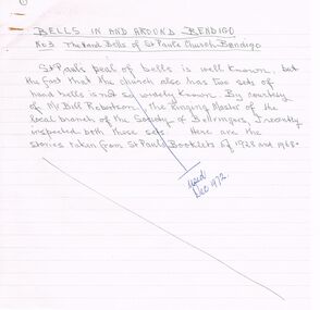
Document - ARTICLES FOR ROYAL HISTORICAL SOCIETY (BENDIGO BRANCH) NEWSLETTER DECEMBER 1972
... ''Memories of Old East Bendigo'' - original draft with alterations in handwriting; mention of 71 Strickland Rd; Government Powder Magazine; Purdon family; the ''Irish Castle'' (at one time the Charlston Hotel); Mr Sullivan; Mr Burns; Pritchard and Chamberlain (brewery); Solomons Hill; Day's asphfelt (sic) and bone works; Marist Brothers 'Jounerate ' (sic)??...''Memories of Old East Bendigo'' - original draft with alterations in handwriting; mention of 71 Strickland Rd; Government Powder Magazine; Purdon family; the ''Irish Castle'' (at one time the Charlston Hotel); Mr Sullivan; Mr Burns; Pritchard and Chamberlain (brewery); Solomons Hill; Day's asphfelt (sic) and bone works; Marist Brothers 'Jounerate ' (sic)?? ...Articles for Royal Historical Society (Bendigo Branch) Newsletter December 1972. 1. ''Bells in and around Bendigo - No 3 - The Hand Bells of St Pauls Church, Bendigo'' - mention of Mr Bill Robertson; Dr J B Pounds; Bendigo Bell Ringers Club; Whitechapel Bell Foundry, London; Odd Fellows Hall; St Pauls Bell Band; Dr A M Bush. 2. ''A sight worth seeing'' - description of the rolling down from the top of Mr Alexander of a large boulder (for entertainment!) in 1860 (extract from the Bendigo Advertiser); mention of Mr Plowright, Talbot Hotel, Harcourt; Mr Wheatcroft.3. ''Memories of Old East Bendigo'' - original draft with alterations in handwriting; mention of 71 Strickland Rd; Government Powder Magazine; Purdon family; the ''Irish Castle'' (at one time the Charlston Hotel); Mr Sullivan; Mr Burns; Pritchard and Chamberlain (brewery); Solomons Hill; Day's asphfelt (sic) and bone works; Marist Brothers 'Jounerate ' (sic)??; Hines Flower Nursery; Mr Hamson MP; Carlile Bros skin and hide store; Kitchen's Soap factory; ''Green Gates'' Hotel; Bendigo Fertiliser Works;bendigo, history, city history. the goldfields. -
 Nepean Historical Society
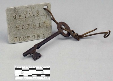
Functional object - Key with Tag
... Also known locally as 'The Castle', likely due to its grand size and turret-like tower, the Nepean Hotel was officially established in 1872 by James Sandle Ford (https://poi-australia.com.au/points-of-interest/australia/victoria/portsea/approximate-site-ford-family-nepean-hotel-c-1870-pt-nepean-rd-near-fitzjohns-crt-portsea-mornington-peninsula-vic/). ...Also known locally as 'The Castle', likely due to its grand size and turret-like tower, the Nepean Hotel was officially established in 1872 by James Sandle Ford (https://poi-australia.com.au/points-of-interest/australia/victoria/portsea/approximate-site-ford-family-nepean-hotel-c-1870-pt-nepean-rd-near-fitzjohns-crt-portsea-mornington-peninsula-vic/). ...This object features a key with a labelled tag attached to it. It was once the key to the well-known Nepean Hotel. Also known locally as 'The Castle', likely due to its grand size and turret-like tower, the Nepean Hotel was officially established in 1872 by James Sandle Ford (https://poi-australia.com.au/points-of-interest/australia/victoria/portsea/approximate-site-ford-family-nepean-hotel-c-1870-pt-nepean-rd-near-fitzjohns-crt-portsea-mornington-peninsula-vic/). Born in 1811, Ford was only nineteen years old when he was sentenced to seven years transportation for 'Machine Breaking' in 1830. (https://nepeanhistoricalsociety.asn.au/james-sandle-ford/). He arrived in Van Diemen's Land (Tasmania) in 1831 and served five years of his sentence, before being pardoned in 1836. Ford met and married Irish immigrant Hannah Sullivan in 1841 in Sydney. The following year, the couple settled in Point Nepean. Ford is often accredited with the naming of the town of Portsea - after Portsea in Hampshire, UK - and spent a lifetime establishing himself throughout the area. This included: lime burning, dairying, horse judging and breeding, and the cultivation of land and livestock. Ford died in 1890, however his hotel continued to operate for many decades, run by his descendants - including Julia Cain during the first half of the twentieth century (https://trove.nla.gov.au/newspaper/article/65817831) (https://trove.nla.gov.au/newspaper/article/3734533). The hotel was demolished in 1971. This object is significant as it is important in relation to the development and prosperity of the area of Point Nepean. A door key with a rusted surface. One end of the key features a single set of teeth with three notches. Attached to the other end is a rounded handle with a hole through the middle. Looped through the hole is a piece of thin, rusted wire. The wire is looped through both the key and a hole in a white square-shaped tag. Printed on the tag are the words: 'CAIN'S HOTEL PORTSEA'. CAIN'S HOTEL, PORTSEAnepean hotel, cain family, james ford, james sandle ford, portsea hotel -
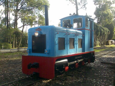 Puffing Billy Railway
Railway Mine and Plantation (RMP) 0-6-0 Diesel Mechanical Locomotive 2' Gauge - "LI'L TOOT", 1951
... Builders Number 3354 Build for Inkerman Mill Queensland in 1951 Displayed at the British Industrial Fair at Castle Bromwich, England 1951 prior to delivery to Australia Weight: 10 Tons Known at Inkerman mill as "LI'L TOOT" Major Ernest E. ...Puffing Billy Railway 1 old monbulk road Belgrave yarra-valley-and-the-dandenong-ranges Builders Number 3354 Build for Inkerman Mill Queensland in 1951 Displayed at the British Industrial Fair at Castle Bromwich, England 1951 prior to delivery to Australia Weight: 10 Tons Known at Inkerman mill as "LI'L TOOT" Major Ernest E. ...Builders Number 3354 Build for Inkerman Mill Queensland in 1951 Displayed at the British Industrial Fair at Castle Bromwich, England 1951 prior to delivery to Australia Weight: 10 Tons Known at Inkerman mill as "LI'L TOOT" Major Ernest E. Baguley (1863–1948) was a British engineer.- In the years leading up to the First World War, Baguley served in the Territorial Army and became Second-in-Command, 6th Battalion, North Staffordshire Regiment, rising to the rank of Major. He served in France from 1914 to 1915. Baguley (Engineers) Ltd After the War there was a decline in the production of road vehicles (probably due to competition from other manufacturers) and an increase in the production of railway equipment. The name of the company was changed from Baguley Cars Ltd to Baguley (Engineers) Ltd on 10 April 1923. Following a dispute with their partners Drewry Cars. Ltd, Baguley (Engineers) Ltd went into decline and entered liquidation in 1931. Most of the plant and effects, including Major Baguley's own Baguley car, were sold at auction on 10 November 1931. E. E. Baguley Ltd Major Baguley was a great survivor of WW1 and, he set up a small repair business for Baguley products at Clarence Street, Burton-on-Trent. A new company, E. E. Baguley Ltd, was registered on 30 April 1932 and was soon building locomotives again. In 1934 E. E. Baguley Ltd moved to larger premises at Uxbridge Street, Burton-on-Trent. The company merged with Drewry to form Baguley-Drewry Ltd in 1962.Historic - Industrial Narrow Gauge Railway Diesel Mechanical Locomotive - Pioneer Sugar Mills - Inkerman Sugar Mill, Home Hill, Queensland, AustraliaRail Mine and Plantation (RMP) 0-6-0 Diesel Mechanical 2' Gauge - " LI'L TOOT " Builders Number 3354 Steel (Painted)RMP / 3354 "LI'L TOOT"rmp, diesel, mechanical, locomotive, 2', 2' gauge, puffing billy, inkerman, li'l toot, industrial narrow gauge railway, e. e. baguley ltd, pioneer sugar mills - inkerman sugar mill, rail mine and plantation (rmp) -
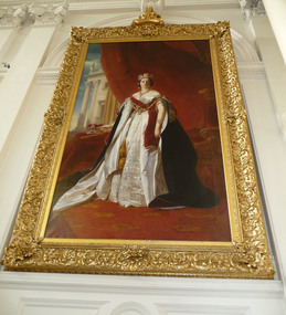 Parliament of Victoria
Portrait of Queen Victoria, Winterhalter, Franz Xaver (After), Queen Victoria, after Winterhalter, c.1859
... These originals hang in the Garter Throne Room at Windsor Castle and are part of the UK Royal Collection. ...These originals hang in the Garter Throne Room at Windsor Castle and are part of the UK Royal Collection. ...Queen Victoria’s appreciation of German artist Franz Xaver Winterhalter (1805-1873) began after she saw portraits by him of other European monarchs. Accordingly, between 1842 and 1861 he made fifteen visits to England and painted over 100 portraits of Her Majesty, the royal family and other friends and dignitaries. In 1843 Winterhalter was commissioned to paint matching portraits of Queen Victoria and Albert, the Prince Consort. These originals hang in the Garter Throne Room at Windsor Castle and are part of the UK Royal Collection. Many legitimate copies of Winterhalter’s portrait were produced and presented to the Parliaments of the British Empire, including the Parliament of Victoria. Such copies are referred to as “After F. X. Winterhalter” and artists responsible include William Corden and John Prescott Knight. When creating copies, artists were not restricted by the size of the original portrait. Walterhalter’s original is 2.7m x 1.7m whereas copies can reach an impressive 4.5 metres in height. The portrait that hangs in Queens Hall at the Parliament of Victoria is not signed. Comparison with other copies of the work suggest that the Parliament’s painting may have been completed by William Corden. The Government Art Collection (United Kingdom), has a Queen Victoria copy in their collection and Parliament’s portrait has similar traits. A copy by John Prescott Knight which hangs in the Legislative Council in the Parliament of Tasmania is quite different, particularly with reference to the shape of the young Queen’s face, which is rounder in the Corden portraits.This portrait of Queen Victoria was presented as a gift by the British Government to the Parliament of Victoria in April 1860. Painted on fine linen supplied under Royal Warrant by the workshop Winsor and Newton, London, the frame has been embellished with elaborate wooden carvings. Framed portrait, oil on linen, of Queen Victoria. Victoria is posed in front of a curtain partially obscuring a building (possibly Buckingham Palace) in the background. Timber frame with a layer of gesso and decorative composition ornaments. There are rose, scotch thistle, clover leaf and Acanthus ornaments. A carved wood and composition element crown, resting on a tassled pillow sits on top of the frame.Canvas unsigned. Verso printed: ‘WINSOR AND NEWTON / Rathbone Place, London’. Embossed stamp into stretcher wood, stamped ‘Winsor and Newton’ in black ink.victoria queen of great britain, 1819-1901, winterhalter, franz xaver, 1805-1873, corden, william, queens hall, parliament of victoria -
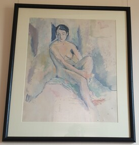 Federation University Art Collection
Painting - Oil on paper, William Frater, 'Nude' by William Frater, 1932
... William FRATER (1890-1974) Born 31 January 1890 at Ochiltree Castle, near Linlithgow, Scotland Arrived Melbourne, Australia in September 1910 In a lecture on modern art in 1925, Frater stated the basic position from which the rest of his oeuvre stems: 'Copying nature is not an art; … to copy effects of light tends to destroy form and colour'. ...Federation University Art Collection Artworks are displayed at Federation University Australia campuses at Ballarat, Gippsland (Churchill), Stawell and Horsham. goldfields William FRATER (1890-1974) Born 31 January 1890 at Ochiltree Castle, near Linlithgow, Scotland Arrived Melbourne, Australia in September 1910 In a lecture on modern art in 1925, Frater stated the basic position from which the rest of his oeuvre stems: 'Copying nature is not an art; … to copy effects of light tends to destroy form and colour'. ...William FRATER (1890-1974) Born 31 January 1890 at Ochiltree Castle, near Linlithgow, Scotland Arrived Melbourne, Australia in September 1910 In a lecture on modern art in 1925, Frater stated the basic position from which the rest of his oeuvre stems: 'Copying nature is not an art; … to copy effects of light tends to destroy form and colour'. Frater gave aggressive leadership to the small group of modernists in the 1920s. His example, teaching, lecturing and crusty style of polemic did much to disrupt the academic style as the arbiter of pictorial values and to pioneer a change of taste in the community.His approach in the 1930s was markedly indebted to Cézanne, especially in the portraits which predominated until his retirement from stained-glass designing in 1940. (L. J. Course, 'Frater, William (1890–1974)', Australian Dictionary of Biography, National Centre of Biography, Australian National University, http://adb.anu.edu.au/biography/frater-william-6239/text10739, published first in hard copy 1981, accessed online 3 May 2016.) Jock Frater was on of the first modern painters who opposed the fashionable and academic schools of painting. During the 1930s he exhibited with the Contemporary Art Group along with Arnold Shore and George Bell. During a very conservative period in Australian Art John Frater advanced the cause of innovation and modernism. This item is part of the Federation University Art Collection. The Art Collection features over 2000 works and was listed as a 'Ballarat Treasure' in 2007.Framed seated nude study in oil on paper. Lower centre in pencil "W. Frater". In lighter pencil "painted 1932"art, artwork, frater, william frater, life drawing, nude, oil on paper, portrait, jock frater, william jock frater, available -
Bialik College
Audio (Item) - Bialik College Senior Vocal Ensemble CD: The Journey, 1995-1997
... Do you hear the people sing? 7. Castle on a cloud 8. Bohemian Rhapsody 9. But-Doi 10. ...Do you hear the people sing? 7. Castle on a cloud 8. Bohemian Rhapsody 9. But-Doi 10. ...CD recording 1995-1997 by the Senior Vocal Ensemble (SVE). Please contact [email protected] to request access to this record. Track list: 1. Will I...? 2. Once Upon a Dream. 3. Fame 4. Amazing Grace 5. I know him so well 6. Do you hear the people sing? 7. Castle on a cloud 8. Bohemian Rhapsody 9. But-Doi 10. Can you feel the love tonight? 11. Once Upon a Dream 12. Sounds of Silence 13. Unlikely Lovers 14. Seasons of Love. Contributors include: Libby Bezoza, Anna Dorevitch, Greg Frid, Elise Hearst, Talia Krape, Gabi Lopata, Alexis Palmer, Ilana Payes, Jo Rosenberg, Beth Sackville, Michelle Samuel, Danny Starr, Adina Trainor, Joanne Warrener, Emily Bock, Zoe Horton, Bianca Olstein, Janine Paynes, Simon Trainor, Julian Fieldman, Jessie Ryderman, Michelle Zeimer. Please contact [email protected] to request access to this record.music, bialik, jewish school, secondary school, student work, 1990s -
 Bendigo Historical Society Inc.
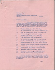
Document - National Trust Collection: two-page nominating 15 properties to retain their cast-iron verandahs, 22/08/1968
... Cumberland Hotel, 279 Williamson Street, Bendigo 10. Limerick Castle Hotel, Williamson Street, Bendigo 11. ...Cumberland Hotel, 279 Williamson Street, Bendigo 10. Limerick Castle Hotel, Williamson Street, Bendigo 11. ...historic significant post verandahsNational Trust - preserving verandahs of significance. Two-page letter between the Central Victorian Branch of the National Trust and the Bendigo District Tourist Association referencing a report to be submitted to the Bendigo city Council, recommending an alteration to the By-Law referring to the removal of verandahs (post type) to exclude certain cast iron verandahs on 15 properties: 1. Shamrock Hotel, 85 Pall Mall Bendigo 2. Dr. Long's Surgery, cnr Mundy & McCrae Street, Bendigo 3. Mrs. RE. Batchelder, 346 Pall Mall, Bendigo 4. F. E. Favaloro, 139 Pall Mall, Bendigo 5. Bendigo Jockey Club, Pall Mall, Bendigo 6. View Point Hotel, View Point Bendigo 7. L. Johnson, Butcher, 247 High Street, Bendigo 8. Hopetoun Hotel, 147 Mitchell Street, Bendigo 9. Cumberland Hotel, 279 Williamson Street, Bendigo 10. Limerick Castle Hotel, Williamson Street, Bendigo 11. B.U.F.S. Dispensary, 75 View Street, Bendigo 12. Rifle Brigade Hotel, 137 View Street, Bendigo 13. Goldmines Hotel, Marong Road, Bendigo 14. Manchester Arms, 302 Eaglehawk Road, Bendigo 15. Victoria Hotel, 48 High Street, Eaglehawk.removal of non-cantilever verandahs and replacement with cantilever verandahs, list of 15 properties recommended to save their post/cast-iron verandahs -
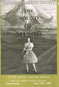 Bendigo Historical Society Inc.
Programme - BENDIGO OPERATIC SOCIETY ''THE SOUND OF MUSIC''
... Cast in Order of Appearance: Carol McKenzie as Maria Rainer 9A Postulant at Nonnberg Abbey) - Elaine Buckland as Sister Berthe (Mistress of Novice) - Suzanne Fraser as Sister Margaretta (Mistresss of Postulants) - Valerie McCracken as The Mother Abbess - Barbara Potter as Sister Sophia - Fred Trewarne as Captain Georg Von Trapp - Philip Johnston as Franz (The Butler) - Julie Hoebert as Frau Schmidt (The Housekeeper) - Julie Lyon as Liesl - Michael Frayne, Bruce Ashman as Friedrich - Leonie Perry, Carol Bourchier as Louisa - Russell Theodore, Tommy Potter as Kurt - Jacinta Hull, Ann Johnson as Brigitta - Cheryl Wottoon, Andrea Smith as Marta - Suzanne Favaloro, Kristin Bolding as Gretl - Ian Richardson as Rolf Gruber - Sandra Sessions as Elsa Schrader - Gwen Cox as Ursula - Glynn Sessions as Max Detweiler - John Higgs as Herr Zeller - Ray Harding as Baron Elberfeld - Bartina Daws as Baroness Elberfeld - David Castles as Admiral Von Schreiber....Cast in Order of Appearance: Carol McKenzie as Maria Rainer 9A Postulant at Nonnberg Abbey) - Elaine Buckland as Sister Berthe (Mistress of Novice) - Suzanne Fraser as Sister Margaretta (Mistresss of Postulants) - Valerie McCracken as The Mother Abbess - Barbara Potter as Sister Sophia - Fred Trewarne as Captain Georg Von Trapp - Philip Johnston as Franz (The Butler) - Julie Hoebert as Frau Schmidt (The Housekeeper) - Julie Lyon as Liesl - Michael Frayne, Bruce Ashman as Friedrich - Leonie Perry, Carol Bourchier as Louisa - Russell Theodore, Tommy Potter as Kurt - Jacinta Hull, Ann Johnson as Brigitta - Cheryl Wottoon, Andrea Smith as Marta - Suzanne Favaloro, Kristin Bolding as Gretl - Ian Richardson as Rolf Gruber - Sandra Sessions as Elsa Schrader - Gwen Cox as Ursula - Glynn Sessions as Max Detweiler - John Higgs as Herr Zeller - Ray Harding as Baron Elberfeld - Bartina Daws as Baroness Elberfeld - David Castles as Admiral Von Schreiber. Programme BENDIGO OPERATIC SOCIETY ''THE SOUND OF MUSIC'' ...Bendigo Operatic Society ''The Sound of Music'' At the Capital Theatre Bendigo For an Eight Night Season Commencing June 11th, 1975. Producer: mMax Collis - Assistant Producer, Wardrobe and Ballet Mistress: Madge Welch - Stage Manager and Director of Design: Malcom Cannon - Musical Director: Gwen Grose - Society Pianist: Dianna Cohn. Cast in Order of Appearance: Carol McKenzie as Maria Rainer 9A Postulant at Nonnberg Abbey) - Elaine Buckland as Sister Berthe (Mistress of Novice) - Suzanne Fraser as Sister Margaretta (Mistresss of Postulants) - Valerie McCracken as The Mother Abbess - Barbara Potter as Sister Sophia - Fred Trewarne as Captain Georg Von Trapp - Philip Johnston as Franz (The Butler) - Julie Hoebert as Frau Schmidt (The Housekeeper) - Julie Lyon as Liesl - Michael Frayne, Bruce Ashman as Friedrich - Leonie Perry, Carol Bourchier as Louisa - Russell Theodore, Tommy Potter as Kurt - Jacinta Hull, Ann Johnson as Brigitta - Cheryl Wottoon, Andrea Smith as Marta - Suzanne Favaloro, Kristin Bolding as Gretl - Ian Richardson as Rolf Gruber - Sandra Sessions as Elsa Schrader - Gwen Cox as Ursula - Glynn Sessions as Max Detweiler - John Higgs as Herr Zeller - Ray Harding as Baron Elberfeld - Bartina Daws as Baroness Elberfeld - David Castles as Admiral Von Schreiber.program, theatre, bendigo operatic society -
 Kew Historical Society Inc
Album, Eva Grant, Historic Buildings in Victoria & New South Wales, 1919-c.1962
... Malvern (Vic) - church Mount Ridley (Vic) - Summerhill Melbourne (Vic) - Old Brewery - Custom’s House Lane (1960), Customs House, Scott’s Hotel (1962), Western market (c.1960) Phillip Island (Vic) - Grave Toorak (Vic) - Mandeville Hall, Merna (sic) - Arthur Streeton’s house, Toorak House Wentworth (NSW) - Harvey’s Hotel, Sturt Memorial, Sturt’s Tree, Wentworth Gaol Williamstown (Vic) - Williamstown Dairy Yan Yean (Vic) - Bear’s Castle (c.1947) Beveridge/Big Hill (Vic) - Kelly’s cottage...Malvern (Vic) - church Mount Ridley (Vic) - Summerhill Melbourne (Vic) - Old Brewery - Custom’s House Lane (1960), Customs House, Scott’s Hotel (1962), Western market (c.1960) Phillip Island (Vic) - Grave Toorak (Vic) - Mandeville Hall, Merna (sic) - Arthur Streeton’s house, Toorak House Wentworth (NSW) - Harvey’s Hotel, Sturt Memorial, Sturt’s Tree, Wentworth Gaol Williamstown (Vic) - Williamstown Dairy Yan Yean (Vic) - Bear’s Castle (c.1947) Beveridge/Big Hill (Vic) - Kelly’s cottage Important photograph record (and notes) about historic buildings in Victoria. heritage sites - victoria - australia eva grant scrapbooks - 20th century See images 38-page scrapbook with additional text created by Eva Grant, a past member of the Kew Historical Society. ...One of three scrapbooks created by Eva Grant, a past member of the Kew Historical Society which were donated by her niece, Julie Thomson, in 2013. The scrapbook includes photographs and descriptions of the following sites. (Many of these are now demolished and so the photographs and descriptions may be rare records of a site.) Sites include: Abbotsford (Vic) - Abbotsford Convent, Mayfield (c.1962), prefabricated house - Church street Armadale (Vic) - church (c.1959) - Thomson & Wattletree Roads Arthur’s Seat (Vic) - McCrae homestead Ballarat (Vic) - Memorial plaque on site of Bentley’s Hotel, Memorial on site of Eureka Stockade, Early municipal buildings - East Ballarat, Adam Lindsay Gordon’s cottage - Botanical Gardens, View from Sovereign Hill, Shell house Broken Hill (NSW) - panorama (1963), Flying Doctor’s base (?1963) Eltham (Vic) - Hassell’s outdoor art gallery Essendon (Vic) - Niddrie Homestead and stables (1963) Geelong (Vic) - first Bishopscourt Hawthorn (Vic) - Convent (1930), The Hawthorns, Keilor plains (Vic) - pioneer homes, pioneer cemetery Kew (Vic) - Roseneath (1951), Tarring - Ruyton, Turinville, house - Foley street (c.1960). Malvern (Vic) - church Mount Ridley (Vic) - Summerhill Melbourne (Vic) - Old Brewery - Custom’s House Lane (1960), Customs House, Scott’s Hotel (1962), Western market (c.1960) Phillip Island (Vic) - Grave Toorak (Vic) - Mandeville Hall, Merna (sic) - Arthur Streeton’s house, Toorak House Wentworth (NSW) - Harvey’s Hotel, Sturt Memorial, Sturt’s Tree, Wentworth Gaol Williamstown (Vic) - Williamstown Dairy Yan Yean (Vic) - Bear’s Castle (c.1947) Beveridge/Big Hill (Vic) - Kelly’s cottageImportant photograph record (and notes) about historic buildings in Victoria.38-page scrapbook with additional text created by Eva Grant, a past member of the Kew Historical Society. In addition to the 68 photographs, there are two postcards and a number of publications/handouts.collected by Eva on her trips to heritage sites in Victoria and New South Wales. The pages of the album can be viewed in the image carousel above. Most of the photographs of heritage buildings were taken in the early 1960s.See imagesheritage sites - victoria - australia, eva grant, scrapbooks - 20th century -
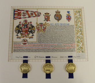 Glen Eira City Council History and Heritage Collection
Letters Patent, Letters Patent for the Grant of Arms to the City of Caulfield presented on 1st May, 1977, 01/05/1977
... From its early years the municipality of Caulfield had used the armorial bearings of the Caulfield Family (the Charlemonts of Castle Caulfield) to represent the roads board and later the town and city. ...From its early years the municipality of Caulfield had used the armorial bearings of the Caulfield Family (the Charlemonts of Castle Caulfield) to represent the roads board and later the town and city. ...Glen Eira has a long history of association with various heraldic forms. From its early years the municipality of Caulfield had used the armorial bearings of the Caulfield Family (the Charlemonts of Castle Caulfield) to represent the roads board and later the town and city. In 1969 Caulfield City Council began planning to apply for an official coat of arms for the City. In 1974 Horace Hall, a Balwyn North resident and member of the Heraldry Society in London advised Council that the current usage was illegal, and that the Houston family, current owners of the Caulfield Arms could take legal action against Council for 'usurping their arms'. Mr Hall was commissioned to develop new heraldry for the City, and in conjunction with J. P. Brooke Little at the College of Arms, London, he prepared an acceptable design for Caulfield's Coat of Arms. The Council paid an additional sum to have a standard painted on the Letters Patent and the municipality's new coat of arms was drawn up in June 1975. The Coat of Arms retains a number of heraldic elements from the original Caulfield family insignia, including the dragons, the colours and the elements of the shield. The newly registered coat of arms and Letters Patent document for the granting of arms was presented at a civic service to mark the granting of armorial ensigns and the city banner to the City of Caulfield on the 1st May 1977. Significant elements of the coat of arms granted by these Letters Patent are as follows: The motto 'Labore Vinces' translates to 'By our labours we will conquer'. The helmet represents the rank of the owner. Public authorities are granted an esquire's helmet. The brickwork on the crest is a recognised emblem of local government. The Letters Patent also display a banner and a badge, both official symbols of the City of Caulfield. The badge, which is displayed on the banner as well as on its own, features a bridled horse. This represents the importance of racing, the Caulfield racecourse and the Caulfield cup to the municipality. These letters patent officially proclaim the granting of the coat of arms to the City of Caulfield. They are highly significant to the City of Glen Eira as they are the primary document that signifies the official and ceremonial heraldic powers of the Coat of Arms of the City of Caulfield. Mounted Letters Patent illuminated document for the Grant of Arms to the City of Caulfield presented on 1st May, 1977. Hand written and hand painted on cream coloured parchment using different coloured inks, mainly black, blue, red and gouache and gold paint. The bottom edge is folded up over itself approx. 45mm revealing the flesh side of the parchment, which displays black ink signatures and three sets of two horizontal slits that hold three blue ribbon. The ribbons support three wax seals in round, gold coloured metal cases held by the wax through slots in the casing. Although covered by the cap top, each wax seal within displays a different flag emblem with a crown on top, surrounded by a ring of text (difficult to read), noted when the cases were opened during conservation treatment. See attached transcription.arms, symbol, heraldry, glen eira, council, caulfield -
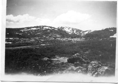 Kiewa Valley Historical Society
7 small black and white photographs of Pretty Valley, c1948
... Photo 6 - on the back, handwritten in ink 'View from Pretty Valley Ruined Castle in Background Nov. 1948'. In pencil '78'. ...Photo 6 - on the back, handwritten in ink 'View from Pretty Valley Ruined Castle in Background Nov. 1948'. In pencil '78'. ...In 1947 it was proposed to construct a dam on the Pretty Valley branch of the East Kiewa River. This was part of the initial planning in 1937. The Pretty Valley Reservoir was to be part of a pumped-storage scheme with a pumping station located immediately below the main structure. Preparatory work was commenced in 1946 with erection of staff accommodation. Between 1947 and 1950 the main camp was erected, access roads, constructed and banks and benches at the dam site undertaken. Following the financial crisis in 1951, a review of the scheme was carried out and work ceased in June 1951. Construction of the dam was deleted from the programme of works and all buildings removed.A pictorial history of part of the initial planning in 1937 for a dam to be constructed at Pretty Valley as part of the Kiewa Hydro Electric Scheme.7 small black and white photographs of Pretty ValleyAll photos have a circular stamp on the back with 'Print by Willson White Albury' enclosed. Photo 1 - on the back, handwritten in ink 'New 22Kv pump line - Pretty Valley Nov. 1948'. In pencil '18'. Photo 2 - On the back, handwritten in ink 'Pretty Valley - Staff mess on right Nov. 1948'. In pencil '18'. Photo 3 - On the back, handwritten in ink 'Pretty Valley Basin - looking S.E. Nov. 1948'. In pencil '5'. Photo 4 - On the back, handwritten in ink 'New pump 22Kv line, Pretty Valley - looking towards Mt. Mackie. Nov. 1948'. In pencil '5'. Photo 5 - On the back, handwritten in ink 'Pretty Valley. Mt. Cope just out of picture extreme right. Nov. 1948'. In pencil '78'. Photo 6 - on the back, handwritten in ink 'View from Pretty Valley Ruined Castle in Background Nov. 1948'. In pencil '78'. Photo 7 - on the back, handwritten in ink 'Pretty Valley Pump line (Nov. 1948)'. In pencil'78'.construct, dam, pretty valley