Showing 10087 items matching "demolished"
-
 Kew Historical Society Inc
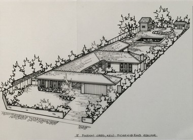
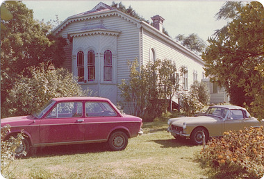
Drawing - Property Illustration, Margaret Picken, 18 Findon Crescent, Kew, 2003
This drawing is one of a series created by Margaret Picken for a number of real estate agents in Melbourne between 1983 and 2005. Each work is signed and dated by the artist.Gift of Margaret Picken, 2020This single-storey residence, built in 1982 to a design by John Chandler (architect) was demolished in 2003, the year in which this pen and ink property illustration was made by Margaret Picken.18 FINDON CRES., KEW / PICKEN © 2003 / REALTORartist -- margaret picken 1950-, architectural drawings -- houses -- kew (vic.), 18 findon crescent - kew (vic)., john chandler (architect) -
 Surrey Hills Historical Society Collection
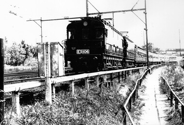
Photograph, Electric loco E1106 at Surrey Hills, 15 February 1964
The occasion was a Railfan tour for the Association of Railway Enthusiasts Belgrave. Photo taken on 15 February 1964.A black and white photocopy of an electric train with about 7-8 carriages. The pedestrian overpass (later demolished) at Surrey Hills railway station can be seen in the background.surrey hills, associations of railway enthusiasts belgrave, trains, 1964, railfan tour, surrey hills railway station, loco e1106 -
 Ringwood and District Historical Society
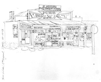
Photograph, Hand drawn picture by Eric Thake dated 1954 depicting Milne's Post Office and Store on the south-east corner of Oban Road and Warrandyte Road, North Ringwood
Typed below picture, "Mr. K. Milnes store. Corner Oban Rd. and Warrandyte Rd. 1954. Now demolished". -
 Ringwood and District Historical Society
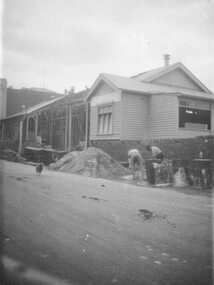
Photograph, Maroondah Highway Central, Ringwood. Extensions to Town Hall- c1930's
Black and white photograph (2 copies- 1 large, 1 small). Image shows old Mechanics Instute in Melboune Street partly demolished and 2 workmen digging foundations for new structure. -
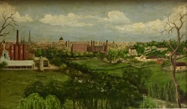 Kew Historical Society Inc
Painting - Panoramic View of Kew and Abbotsford from the garden of Rockingham, V Maloney, 1952
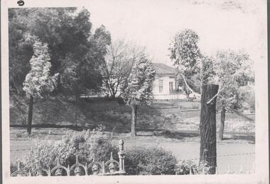
The extensive formal landscaped gardens of Rockingham had been created in the 1860s, and by the 1950s remained bordered to the south by the Barkers Road cutting, and to the north by Blytheswood, the neighbouring Syme family property, By 1940, the Syme family were no longer the occupiers of Rockingham. John Herbert Syme had died in October 1939, and by August the following year, his wife had made the house and garden available, rent free to the Red Cross as a convalescent home for Australian soldiers injured in the Second World War. At the time, the house was described as containing twenty rooms, including a ballroom and a billiards room, with a garden of eight acres overlooking the Yarra. The task of renovating the house to conform to its new function as a convalescent home took a year, finally opening in August 1941. Community support for Rockingham was widespread and included the decision by the National Gallery of Victoria to loan pictures from its collection to decorate the walls. Calls were made for women around Victoria to donate fruit and vegetables from their gardens, which the railways agreed to freight for free. Other local support included the work by a team of boys to establish a three-acre vegetable garden within the formal terraced gardens. From the beginning, occupational therapy formed a key component of the rehabilitation of psychologically injured soldiers. This is confirmed by contemporary newspaper accounts of weaving, ironwork, leatherwork, basketry and gardening by patients. Numerous photographs, held by the Australian War Memorial (AWM) and the State Library of Victoria (SLV), record the importance of these rehabilitation activities. The painting of the view across the river to Abbotsford may have been painted in one of these occupational therapy sessions. For many decades it hung in the occupational therapy room. It must have been on view following the sale of Rockingham by the Syme family to the Red Cross in 1955, and subsequently, until the house was demolished and its grounds finally subdivided in 1977.View of Abbotsford from the garden of Rockingham (1952) was created by V Maloney. The vantage point of the artist was the garden of Rockingham, one of two mansions overlooking the Yarra owned by the Syme family. The artwork depicts a number of sites - especially factories - that have since been demolished.Signed by the artist, lower right "V Maloney"rockingham red cross convalescent home, hospitals - kew (vic), rosemary lade, art therapy -
 Ringwood and District Historical Society
Photograph, Burnt Bridge Store, Feb 1960 (2 views)
Written on back of one photograph, "Burnt Bridge Store. Demolished 1969. New World super market and shops built on or about site. Feb. 1960". On another copy "Ex BB Hotel, Demolished 3-4.69". On another copy: "Old Burnt Bridge Hotel (Sam Cutts)" -
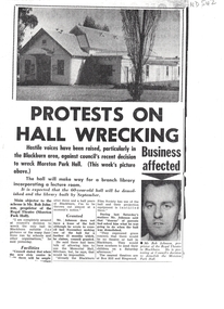 Whitehorse Historical Society Inc.
Article, Protests on hall wrecking, ca 1965
Article on Council decision to demolish Moreton Park Hall (used as Regal Theatre) in order to build a branch library (ca 1965).Article on Council decision to demolish Moreton Park Hall (used as Regal Theatre) in order to build a branch library (ca 1965). Copy from scrapbook of Jessie Wiliams.Article on Council decision to demolish Moreton Park Hall (used as Regal Theatre) in order to build a branch library (ca 1965). moreton park hall, regal theatre, blackburn, blackburn branch library, williams, jessie, johnson, bob -
 Whitehorse Historical Society Inc.
Photograph, Vermont Intersection C.1967, 1/04/1967 12:00:00 AM
Part of Tim Shambrook's Collection for 'This is Vermont', P. 37.Coloured photo of Corner of Canterbury, Mitcham & Boronia Roads, Vermont, looking towards Boronia Road, showing Vermont Shops and corner of Vermont Primary School, since demolished.canterbury road, vermont, mitcham road, boronia road, shambrook, tim -
 Whitehorse Historical Society Inc.
Photograph, 4 Edward Street, Mitcham
Coloured photo - 4 Edward Street, Mitcham. Demolished 1991. Site now contains a pair of semi-detached houses consisting of numbers 4 and 6 Edward Street.edward street, mitcham -
 Northern District School of Nursing. Managed by Bendigo Historical Society Inc.
Photograph - "McEniry House" demolished
The Northern District School of Nursing opened in 1950 in to address the issues around nurse recruitment, training and education that had previously been hospital based. The residential school was to provide theoretical and in-house education and practical training over three years. The students would also receive practical hands-on training in the wards of associated hospitals. The Northern District School of Nursing operated from Lister House, Rowan Street, Bendigo. It was the first independent school of nursing in Victoria and continued until it closed in 1989.NDSN McEniry House, Short Street Bendigo, demolished for new buildings for Lister House Two B&W photos of house taken from different angles/streets.8594.15a Short Street. 8594.15b NcInireys.ndsn, nursing -
 Whitehorse Historical Society Inc.
Photograph, Creek Road Mitcham 1939/40, 1939/40
George Thompson had just come home from New Zealand. In the photo is sister Mavis Thompson and possibly George's parentsBlack and white photo taken in 1939/40 of weatherboard house built about 1922 in Creek Road, Mitcham - now called Bird Street. The house is now demolished.creek road mitcham, thompson, george -
 Wodonga & District Historical Society Inc
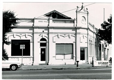
Photograph - Codling Collection 01 - Wodonga Shire Hall
Miss Olive Codling was a Foundation Member and a Life Member of the Wodonga Historical Society. Many of her prize-winning photos are held in the Society Collection. She also held a range of roles and committee positions in a wide range of Wodonga community organisations. These included the Horticultural Society, the Wodonga Arts Council, the Wodonga Camera Club and the Wodonga Lapidary Club. Wodonga Shire was created in 1876 when the colonial government agreed to ratepayers' petitions to have their part of the local government district severed from the Yackandandah Shire to form a new municipality. After meeting for 14 years in rented premises, in the Prince of Wales Hall, Wodonga Council built its first Shire Hall on the corner of High and Elgin Streets in 1890. The date on the facade of the building represents the date of the formation of the Shire.This image is significant as it documents an important building and era in the development of local government in Wodonga.Wodonga Shire office at corner of High street and Melbourne Road Built 1876 demolished 1971 . Now the location of Woolworths shopping complex. Also incorporated the Melba Theatre On facade of building: " A.D. 1876"high st wodonga, wodonga local government, shire hall wodonga -
 Lakes Entrance Historical Society
Photograph - Central Hotel Lakes Entrance, Holding M, 2005
Date made May 2005Colour photograph showing rear of 1930's tower of the Central Hotel. Dining room and other rooms have been demolished in readiness for the rebuilding. Lakes Entrance Victoriahotels, tourism -
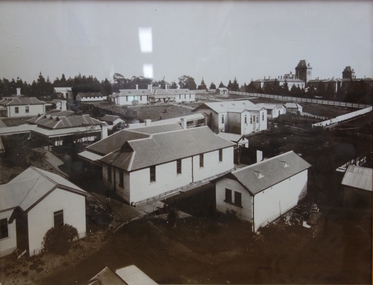 Kew Historical Society Inc
Photograph - Wards 11,12,13,13A, Kew Cottages
The Children's Cottages at Kew were first opened in 1887 as the "Idiot Ward" of Kew Asylum. Located on the asylum's grounds, the children's cottages were established to provide separate accommodation for child inmates who had previously been housed with adult patients. Although the Cottages only admitted children as patients, many of those children remained in residence at the Cottages as adults. The function of the institution was to provide accommodation and educational instruction for intellectually disabled children. Some Wards of the State and other various "difficult" children were also admitted.Shortly after opening, the Idiot Ward began functioning separately from the Kew Lunatic Asylum, and became known as the Kew Idiot Asylum from 1887 until c.1929. From 1929 they have been known as the "Children's Cottages, Kew" or alternatively "Kew Cottages Training Centre". The institution was finally closed in July 2008. [Source: Wikipedia, 2016]One of a series of framed historical photographs of the Kew Cottages that once formed part of the collection of the Kew Cottages Historical Society, founded by Dr. Cliff Judge and Fran Van Brummelen in the 1980s. The set contains both copies of originals in other collections such as the Public Record Office Victoria and photographs taken by Dr Judge for his books on intellectual disability in Victoria. The significance of the set of framed photographs is that they provide a curated collection of images of the development of the Cottages over a one hundred year period.Framed photograph, forming part of the Kew Cottages collection, donated by Kew Cottages Historical Society 1987-1993 in 1993. Dr. Judge was a consultant psychiatrist at the cottages for 14 years, as well as an author and vocal advocate for the intellectually disabled and their families."Kew Cottages - Wards 11,12,13,13A. Wards 11, 12, 13 and 13A. The Hospital Ward is in the background. Ward 13A was demolished in 1966."kew cottages, dr cliff judge, kew cottages historical society 1987-1993 -
 Ringwood and District Historical Society
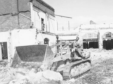
Photograph, Maroondah Highway Central, Ringwood. Demolishing Coffee Palace and shops, corner of Maroondah Highway and Adelaide Street, 1966
Black and white photographWritten on back of photograph: "Demolishing Coffee Palace and shops on corner of Maroondah Highway and Adelaide St (west corner) Ringwood. 1966." -
 Kew Historical Society Inc
Photograph - 'Reno', 10 St John's Parade, John T Collins, 1977
‘Reno’, stood on the east side of St John’s Parade. Its earliest recorded owner was the architect Samuel Cocking who lived there from c.1865 until his death in 1888. The original landholding was bordered by Cotham Road, Glenferrie Road, Wellington Street, and Charles Street. The southern portion of this land included a fine orchard, with many imported trees. The old summer house, at first in the orchard, was later removed to the house garden. The MMBW Detail Plan No.1576 (1904) shows the remaining portion of the original land holding, including a semi-circular pathway at the front, and garden features such as an aviary, a fountain and grotto, and a fernery. The garden including rare plants supplied by Baron Von Mueller, surrounds the cottage in a tangled frenzy. Despite a ‘local significance’ classification by the National Trust, the house was demolished in 1977.Partial view, north side of the weatherboard cottage in St John's Parade, Kew, known as 'Reno' (demolished 1977). Architectural elements revealed in this photo by John T Collins include: two wing, hip roof construction; external buildings at angles to main wing; corrugated iron roofing [over shingles]; brick chimney external to building; unvarnished/unpainted external weatherboards. General dilapidated condition. "Kew 'Reno' 10 St Johns Pde / John Collins, 11 Anderson Road, Hawthorn East, 3123, Film 35B Exposure 27"reno - st john's parade -- kew (vic.), john t collins -
 Federation University Historical Collection
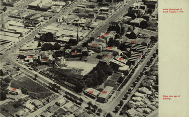
Photograph - Image, Aerial Image of the Ballarat School of Mines, 1976, 1976
Black and white aerial Image of the Ballarat School of Mines, with the date of the construction of each building indicated in red. The image shows the site after the Ballarat Gaol and the Ballarat Brass Works (M.B. John) buildings have been demolished. It includes the former Battery Building, tennis court which were demolished to make way for the M.B. John Building on Albert Street. It also shows the former Ballarat Girls' Technical School.former ballarat gaol, former ballarat brass works, m.b. john building, battery building, tennis court, albert street, grant street, lydiard street south, armstrong street south, ballarat girls' technical school. -
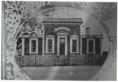 Buninyong & District Historical Society
Photograph - Photo of Original Photograph, Buninyong Shire Hall, Mt. Clear, 1988
historic, buildingB/w photograph, Buninyong Shire Hall, Mt. Clear, Cnr Geelong Rd & Green Hill Rd., built by Richard Rennie 1869, demolished 1915, architect J.A.Doane.buninyong shire, shire hall, rennie, doane -
 Whitehorse Historical Society Inc.
Newspaper - Article, Brick or two from the past, 8/06/1988
Article in Nunawading Gazette about Don Watts with a souvenir brick made by Blackburn brick and tileworks from the demolished Blackburn Dairy his father built in Railway Road in 1933.watts, don j., watts, felix (fred), watts, fred, ireland's dairy, parton's dairy, budd, m (mrs), blackburn dairy -
 Whitehorse Historical Society Inc.
Photograph, Mitcham Primary School
Coloured photo of Mitcham Primary School, Eastern corner facing North. Seating. Sandpit. This new section of MPS N0. 2904 was built to relocate/replace demolished Junior Schoolmitcham primary school, no. 2904 -
 Whitehorse Historical Society Inc.
Photograph, Mitcham Memorial Hall
The Memorial Hall on Mitcham Road Mitcham, opened officially on Sunday 13 June 1926. The RSL used the hall until 1951, when it was sold to the Nunawading Council to be used as a community facility. In 1993 Nunawading Council sold the hall site.Three coloured photographs a-c of the Mitcham Memorial Hall (demolished). The statue of the soldiers in the foreground has been removed to Halliday Park, Mitcham. Whitehorse Road is in the foreground of each photograph.mitcham memorial hall -
 Bendigo Historical Society Inc.
Slide - No 104 Garsed Street Bendigo
No 104 Garsed Street Bendigo - Late Edwardian c1925-1930 - Slide from the National Trust of Victoria, Bendigo Branch - Could not find on Google Street View; believed demolishedhistory, bendigo, national trust collection bendigo, 104 garsed street bendigo -
Kew Historical Society Inc
Archive (Sub-series) - Subject File, Churches (Kew), 1958
Various partiesReference, Research, InformationSecondary Values (KHS Imposed Order)Subject file containing information about varying churches in Kew and Kew East. A number of articles relate to the Kew Congregational Church in Walpole Street Kew (Vic), demolished in 1978. File also includes 1919 Victorian Protestant Federation Annual Convention. churches -- kew (vic.)churches -- kew (vic.) -
Kew Historical Society Inc
Archive (Sub-series) - Subject File, Clifton House [Studley Park Road], 1958
Various partiesReference, Research, InformationSecondary Values (KHS Imposed Order)Subject file containing a transcribed copy of a sale notice from 1867 of Clifton House, later demolished by George Ramsden to build Byram (aka Goathland, Tara Hall etc).houses -- kew (vic.), clifton house, stevenson brothers, studley park road -- kew (vic.)houses -- kew (vic.), clifton house, stevenson brothers, studley park road -- kew (vic.) -
 Kew Historical Society Inc
Photograph - 'Neama', Studley Park Road, 1978
Edward Augustus Atkyns was born in Wiltshire, England in 1840. His family emigrated to Australia in 1852. As a young man he was a keen cricketer and played at the first cricket ground in the district, located between Barkers Road and Hawthorn Grove, on the site of the future Barker railway station. Atkyns was admitted to the Victorian Bar in 1861, initially working in his father’s practice. He sat as a local magistrate in both Kew and Hawthorn and acted as solicitor for several shire councils. Elected to the Hawthorn Borough Council in 1863 at the age of 23, he served in that municipality as mayor in 1866-67. By 1877, he had moved to Kew where he lived at Neama in Studley Park Road, a property later incorporated into the St Paul’s School for the Blind.Rare colour photograph of what was once a significant house in Kew.Original colour positive photograph (Kodak print) of the main house of 'Neama', colloquially known as the 'farmhouse'. Photographed by Stewart West in April 1978 (it was later demolished by the Villa Maria Society).Annotated reverse: "Front view of Neama / Farmhouse on St Paul's School for the Blind Children / Fernhurst Estate"st paul's school for the blind, neama, studley park road -- kew (vic.), historic houses -- kew (vic.), villa maria society -
 Kew Historical Society Inc
Photograph - 'Neama', Studley Park Road, 1978
Edward Augustus Atkyns was born in Wiltshire, England in 1840. His family emigrated to Australia in 1852. As a young man he was a keen cricketer and played at the first cricket ground in the district, located between Barkers Road and Hawthorn Grove, on the site of the future Barker railway station. Atkyns was admitted to the Victorian Bar in 1861, initially working in his father’s practice. He sat as a local magistrate in both Kew and Hawthorn and acted as solicitor for several shire councils. Elected to the Hawthorn Borough Council in 1863 at the age of 23, he served in that municipality as mayor in 1866-67. By 1877, he had moved to Kew where he lived at Neama in Studley Park Road, a property later incorporated into the St Paul’s School for the Blind.Rare colour photograph of what was once a significant house in Kew.Original colour positive photograph (Kodak print) of the secondary building at 'Neama', colloquially known as the 'hall'. Photographed by Stewart West in April 1978 (it was later demolished by the Villa Maria Society).Annotated reverse: "Timber hall on Fernhurst land / Transported there approx 1878."st paul's school for the blind, neama, studley park road -- kew (vic.), historic houses -- kew (vic.), villa maria society -
 Tarnagulla History Archive
Photograph of double-fronted weatherboard shopfront, Tarnagulla, Late 1960s
Murray Comrie Collection. Building is on Commercial Road and in 2019 is a private residence. History to be confirmed.Monochrome photograph depicting a white double-fronted weatherboard shopfront, with six-post verandah, formerly located at 107 Commercial Road in Tarnagulla. Building has since been demolished.tarnagulla, buildings -
University of Melbourne, Burnley Campus Archives
Plan, Proposed Tennis Court, School of Horticulture Burnley, 1956
Hand drawn plan of proposed tennis court and its position in the Gardens. Built with funds raised by the Ladies' Auxiliary in 1961 and demolished February 1990 to make way for new laboratories.Signed THK(?) 15/7/56ladies' auxiliary, burnley school of horticulture, tennis court -
 Whitehorse Historical Society Inc.
Photograph - Coloured Photograph, Mullins House and Orchard East Burwood, 1982
Coloured photo of Old House on Burwood Highway, East Burwood, since demolished. Home of Mullens Family. Now the site of the Eastern Suburbs Geriatric Centre (Peter James Centre).peter james centre, eastern suburbs geriatric centre, mullens, mullens family -
Federation University Historical Collection
Document, Graeme Tyrrell, Overview for the Development of Gardens Lydiard Street Campus, 1988, 01/12/1988
The report was prepared by Graeme Tyrrell, headgroundsman/Gardener at the Ballarat School of Mines (SMB) for Bob Feary, Manager of Facilities at SMB. The report was designed to present a broad cover of current plans for specific sites at the Lydiard Street campus.Seven page report on the development of the Ballarat School of Mines Gardens, including the Motor Mechanics Portable, Hickman Street (now demolished); Recreation Building (now demolished), E.P.U.Y Building, Hickman Street, vacant block behind creche (now site of UBTec building); Creche, Grant Street (now demolished); Former Courthouse building, Grant Street terrace, Brick Court yard, conifer beds lining Lydiard Street, Herb Garden above M.B. John Building, Terrraced area above Ballarat School of Mines Botanical Garden (referred to as Von Mueller garden). The report includes a campus plan. The report is copied onto white paper and is stapled at the top left corner. ballarat school of mines botanical gardens, ballarat school of mines, bob feary, graeme tyrrell, gardens, ballarat school of mines campus, smb campus