Showing 490 items
matching floods road
-
 Melton City Libraries
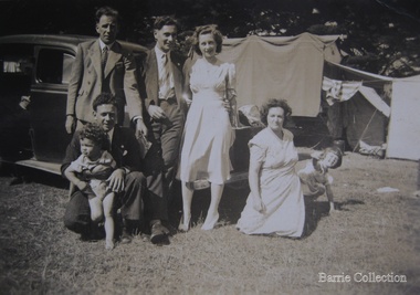
Photograph, Edna and Bon's family camp trip at Apollo Bay, 1948
Wendy Barrie's memories of Apollo Bay The camping trips were a yearly event after the harvest had finished. The trip down to the beach was a much-anticipated event heading out through Parwan and to Geelong leaving behind the hot and dusty plains and our parents relieved to have the hard work of harvesting left behind. The Otways in the distance were reached with great anticipation, Mum in the car and Dad in the Truck ahead of us anxiously winding through the narrow roads and negotiating the hairpin bends and breathing in the cool fresh air of the forest, and keeping an eye out of the log trucks that might come sweeping the corner. The tree ferns with their dripping moisture and the giant trees and the unmistakeable small of the eucalypts. Great excitement was when we caught our first view of the sea from the highest point of the road and then is was the cautious drive the sea level to the sight of the blue ocean with the white of the waves crashing on the rocks and the pristine sand. The water from the Wild Dog and Skenes creek trickling onto the ocean. The tree ferns with their dripping moisture and the giant trees and the unmistakeable smell of the eucalypts. The return journey was usually taken on the Great Ocean Road, it was considered safer to be on the inside of the road. In the early days it was very narrow and passing oncoming cars was taken very cautiously. Landslides and floods sometimes meant we would take the inland route. One year the bridges were washed away and bailey bridges were erected to keep the road open. Rock falls off the cliffs were common Stops on the way home gave us our last chance for our feet in the sand and a swim in the ocean. By the time we reached the hill at Angle Sea the vast blue ocean was behind us and we trekked back through Geelong- Bacchus road and the plains of stubble and the dry grass, and sometimes evidence of burnt patches from a bush fire. The closest we came to a pool at home was the concrete sheep trough at the gate to the work sheds. It was filled with bore water pumped from the nearby windmill. Edna, Bon and their family members at their camp site in Apollo Baylocal identities -
 Melton City Libraries
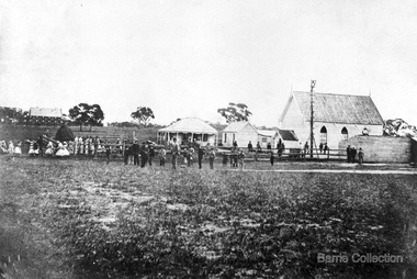
Photograph, Denominational Church and School, Unknown
Presbyterian Church Melton Background: A Combined Denominational Church and School was established in Melton by Protestants from the Presbyterian, Episcopalian, Wesleyan and Baptists denominations. A wooden church was built on the flat area east of the Toolam Toolern Creek. A photo of this church shows the buildings with small houses nearby. In the background the bluestone Presbyterian Church built in 1867 can be seen to the north on Yuille and Sherwin street. The flat area beside the road to Ballarat was subject to flooding and the site was eventually abandoned for a settlement. By the latter part of the 1860s the Church of England and Wesleyan bluestone churches were also being erected in the centre of the township of Melton. The commercial centre developed in High Street from Smith to Palmerston Street. Township of Melton Crown Grants Issued Under Common Law refers to the site of the Combined Denominational Church and School on the east side of Sherwin Street on the corner of Pyke Street. Section 4 Allotments 1 and 10 situated on the corner of Pyke, Bryan and Sherwin Street. The early map has the name of Thomas Cridge on this site. The area known Common (flat) remained open level ground with some cottages and buildings and a milk cooler in the 1930s, Granny Watts house “Lynch Cottage was moved in 1964. Sherwin Street was used until the 1960s with the open area being the used for playing golf. Alterations to the flat occurred when the golf course added to the height and removed the Sherwin Street access. The greens were developed and the height of ground altered the vista across Common. The first Presbyterian Minister in the district was the Reverend Alexander McNicol an advanced student and an experienced missionary from Glasgow, arriving in Melbourne in 1850. He was ordained on the 8th of June and was called to the Bacchus Marsh and Mount Macedon district. On the 1st of May 1851 he was called to Geelong and returned to Bacchus Marsh on February 1856 remaining until July 1859. Group of people in front of the church and school.churches, local identities, education -
 Wodonga & District Historical Society Inc
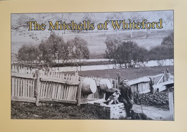
Book - The Mitchells of Whiteford, Paul Mitchell, 2020
"Whiteford is a mystical place. A small farm in north-east Victoria, rising from the rich flats of the Mitta Mitta River a few kilometres upstream from its confluence with the mighty Murray River. Taken up in 1879 from the large Bethanga run, Whiteford was home to the Mitchell family until it was flooded by the Hume Weir around 1934. Through this collection of family photos and small stories, we might glimpse something of family and farming in the fertile Mitta Mitta Valley before it was flooded by the Hume Weir" - Paul Mitchell, author.A family history of the Mitchell family of Whiteford, Victoria. This publication includes stories and many black and white images of the Mitchell family and their home."Whiteford is a mystical place. A small farm in north-east Victoria, rising from the rich flats of the Mitta Mitta River a few kilometres upstream from its confluence with the mighty Murray River. Taken up in 1879 from the large Bethanga run, Whiteford was home to the Mitchell family until it was flooded by the Hume Weir around 1934. Through this collection of family photos and small stories, we might glimpse something of family and farming in the fertile Mitta Mitta Valley before it was flooded by the Hume Weir" - Paul Mitchell, author.mitta mitta history, mitchell family history, whiteford mitta mitta valley -
 Wodonga & District Historical Society Inc
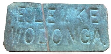
Sign - Name Plate E. Lemke Wodonga
The dairy farm of Eric Lemke and family was located on the Wodonga flats on the Murray River flood plain, west of the Union Bridge. The property was named "Waterford". They ran a large dairy herd (250 cows) and ran five milk carts to Albury to service their customers. The family bought a second property at Wodonga West, on Felltimber Creek, where herds could be rested before calving, and also as an emergency location for milking during times of flood, which sometimes lasted for several weeks at a time. At other times when the cows finished their lactation period at "Waterford" they would be walked to the Lemke property at Wodonga West, for a rest before calving. When the calves were drafted it was a matter of gathering the cows and calves and walking them back home which was an all day job. During the Depression Mr. Lemke took milk to the out-of-work men who slept under the bridges on the causeway and Mrs Lemke would make bread for them. The men would often work on the farm without wages in return for the Lemke's kindness. The Lemke Family are ranked amongst the top early settlers of the district for their perseverance during the hardships of the early days and during the Great Depression. Lemke Road on Gateway Island, Wodonga is named in their honour.This item has local significance because it came from a prominent Wodonga family business.A small metal tag used to label dairy cans on the property of Eric Lemke.E. LEMKE WODONGAe. lemke wodonga, lemke family, wodonga dairy industry, ernie lemke -
 Wodonga & District Historical Society Inc
Album - Ringer's River by Des Martin - Plate 29 - Keiran drowns
A flash flood caused by the cloudburst upstream catches them all in the river and Keiran is drowned.The album and images are significant because they document literature written by a prominent member of the Wodonga community. The presentation of this precis was supported by several significant district families and individuals.Ringer's River Album Coloured photo Plate 29des martin, many a mile, ringer's river, northeast victoria stories -
 Wodonga & District Historical Society Inc
Album - Ringer's River by Des Martin - Plate 1 - Sean O'Day, Horse Breaker at "Gooloora" discusses his future
On a summer's day in 1891 Sean O'Day, Horse Breaker on James MacLough's "Gooloora" Station, is driving the Scots pastoralist in to the railhead at Overton after his annual inspection of that property. Silent and mature for his age, Sean was born in a dray while it was crossing the river during a flood, and has remained at home in it. Because he is always moving by dawn he is known in the borderland as Daylight O'Day. When MacLough asks him what he will be doing on the morrow O'Day replies that he will be manager. Questioned, he suggests that MacLough realises the background to his joke in that the station hands will, that night, celebrate the passing of the Boss's inspection. As they will have hangovers tomorrow all the work will naturally fall to himself, a teetotaller. MacLough nods assent, but, instead of leaving on the train, books a room for the night and a livery gig for the morrow, and drives himself to Gooloora early next morning. D.J. Martin as O'Day, H.S. Diffey as MacLough.The album and images are significant because they document literature written by a prominent member of the Wodonga community. The presentation of this precis was supported by several significant district families and individuals.Ringer's River Album Coloured photo Plate 1des martin, many a mile, ringer's river, northeast victoria stories -
 Wodonga & District Historical Society Inc
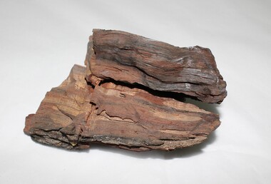
Geological specimen - Murray River Red Gum Geological Specimen c. 6000 BP
This wood was cut from a 6000 year old Murray River red gum retrieved from the Wodonga gravel pits on the flood plain. The Museum of Victoria displayed this wood in the base on which Phar Lap stands. It was made by Kevin Barton of the Kiewa Valley to the order of Dr. James Bowler, the geologist who dated the ancient gravel pit red gums. This specimen is historically significant and unique in local, national, and international context. It is unique, of scientific and research value, and exceptionally rare due to its age. 6000 year old wood from a Murray River red gum. geology, geological, murray river, red gym, murray river red gum, kiewa, wodonga, history -
 Wodonga & District Historical Society Inc
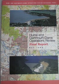
Book - Hume and Dartmouth Dams : Operations Review Final Report and Recommendations, Hume and Dartmouth Dams Operations Review Reference Panel, May 1999
During 1997 and 1998, the Hume and Dartmouth Dams Operations Review Reference Panel has undertaken a broadly based review of the way in which these two major water storages were operated. The Panel’s terms of reference were essentially to consider how the operating rules might be amended to better address the competing objectives of water supply, environmental enhancement and flood mitigation. This report includes summaries of feedback considered by the reference panel as well as its final recommendations.non-fictionDuring 1997 and 1998, the Hume and Dartmouth Dams Operations Review Reference Panel has undertaken a broadly based review of the way in which these two major water storages were operated. The Panel’s terms of reference were essentially to consider how the operating rules might be amended to better address the competing objectives of water supply, environmental enhancement and flood mitigation. This report includes summaries of feedback considered by the reference panel as well as its final recommendations.hume reservoir nsw, dartmouth dam victoria, water management -
 City of Kingston
Photograph - Black and white, c. 1958
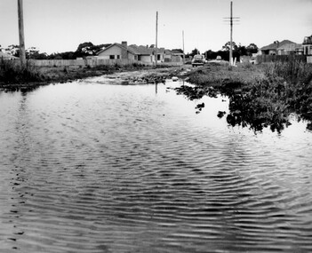
... residents. Beaumaris Ozone Avenue Balcombe Road Flooding Roads ...This photograph depicts flooding of Ozone Avenue in Beaumaris, located off Balcombe Road. Roads in the Beaumaris area lacked sufficient drains to clear surface water. In many cases streets were unsealed and without footpaths and some were dirt tracks. Gutters and road surfaces were made of clay and in the wetter months of winter, unsealed roads and tracks became impossible quagmires that were unnavigable for vehicles and pedestrians. In the first decade after World War II there was rapid expansion in construction of new houses in the suburb of Beaumaris. Utilities and infrastructure to support the growth of housing was inadequate and not provided for prior to the development of the area. Without rudimentary drainage, flooding was frequent. Storm water runoff, domestic sullage and septic tank overflow would form large pools and families were sometimes marooned within their homes. The frequent flooding caused isolation and hardship and residents endured difficulties with accessibility to facilities. These disadvantages had the potential to cause social issues for the new residents.Black and white photograph of flooding in Ozone Avenue, Beaumaris. The image shows floodwaters with boggy and rough terrain on an unsealed road with housing in the distance.Handwritten in blue ink: 2124 circled Handwritten in red ink: 80% Handwritten in blue ink on yellow Post-It note: Chap 6. underlined, 2194 Ozone Ave Beaumaris 1958beaumaris, ozone avenue, balcombe road, flooding, roads, infrastructure -
 Port Melbourne Historical & Preservation Society
Book - Town of Port Melbourne, Arthur Victor Heath, Town Surveyor et al, Surveyors Report Book, 1901
Reports to Council hand entered by Town Surveyor and ATS, with marginal notes on actions taken by Council.Book of reports of Port Melbourne Town Surveyor 1901-1911: 475 pp volume bound in dark green with maroon spine and corners. Gold stamped on spine 'Minute Book' but added leather label below reads 'Surveyors Report Book'. Some inserts (glued in)Stamped inside cover and on some pages, 'Town of Port Melbourne Surveyors Office'sandridge lagoon, local government - town of port melbourne, fishermans bend, flood, fire and fire services, port melbourne town hall, transport - horse, transport - tramways, parks and gardens, engineering - roads streets lanes and footpaths, excelsior hall, societies clubs unions and other organisations, built environment, industry - manufacturing, engineering - canals and drainage, crimes and misdemeanours, transport - ferries, south melbourne, arthur victor heath, george beazley, h v champion, business and traders - hotels -
Port Melbourne Historical & Preservation Society
Book - Borough of Sandridge, Charles Clay, Borough Surveyor, Surveyor's Reports, 1877
Surveyor Charles CLAY's reports to Council March 1877 to June 1882, handwritten. 176pp volume bound in maroon linen with red spine; sticker on front: MINUTE BOOK; 'Surveyor's Reports' hand printedThree names/addresses noted on first page. Two printed Agendas 1881 and 1882 pasted in front.local government - borough of sandridge, engineering - roads streets lanes and footpaths, port melbourne town hall, transport - tramways, engineering - canals and drainage, celebrations fetes and exhibitions, business and traders, fishermans bend, fire and fire services, flood, engineering - bridges, utilities, health - general health, built environment - domestic, industry - manufacturing, livestock, transport - railways, charles clay, sandridge lagoon, business and traders - hotels -
 Charlton Golden Grains Museum Inc
Photograph, Flood 1911, c.1911
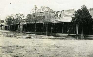
Flood 1911. High St Charlton showing Golden Fleece Hotel and W. Wylie General StoreSmall black & white snapshot showing Golden Fleece Hotel and W. Wylie General Store. Two children standing on the footpath. Water on the road in front of them. charlton, flood, willey, willey store -
 Lakes Entrance Historical Society
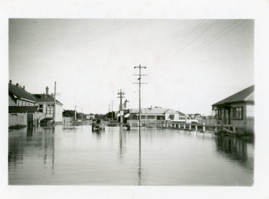
Photograph - Floods, 1952
... Date made June 1952 Floods Halls Houses Roads and Streets ...Date made June 1952Black and white small format photograph of flood waters in Mechanics Street, showing extent of inundation around Mechanics Hall on left and having housing on right of image looking towards Cunninghame Arm. Lakes Entrance VictoriaOn reverse - Flood water near Mechanics Hall June 1952. The pumps were working when this was taken.floods, halls, houses, roads and streets -
 Lakes Entrance Historical Society
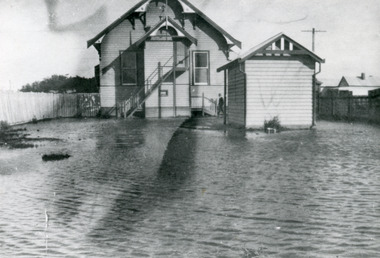
Photograph - Floods, 1934
... lying areas of Lakes Entrance flooded. Floods Halls Houses Roads ...Severe flooding all over Gippsland in August 1934. All low lying areas of Lakes Entrance flooded.Black and white photograph of flood waters around the Mechanics Hall. Shows external stairway to bio-box addition for film projector. Mr Syd Allen projectionist seen at lobby steps. Lakes Entrance VictoriaOn Back Old Cat No 77floods, halls, houses, roads and streets -
 Warrnambool and District Historical Society Inc.
Footwear - Child's boot, 1940s
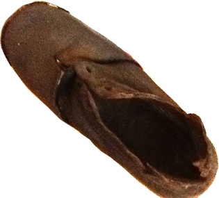
This small shoe (or boot) was found at Rosebrook, a small settlement between Warrnambool and Port Fairy, after the 1946 Western District floods. These floods are regarded as the worst in the history of European settlement in the Western District. At least five lives were lost, many small settlements and towns were isolated resulting in food shortages, onion and potato crops were ruined, 20 bridges were destroyed or damaged, roads were swept away, hundreds of farm animals perished and road and rail services were disrupted. The floods were the result of a very high rainfall in five successive days (658 points of rain in one 24 hours) and there was more flooding a week after the first major impact of the rains. A link to a major weather event in the South west.This is a small child’s brown shoe made of leather with a lace-up upper part (no laces) and a leather sole. The sides of the upper part of the shoe have broken away at the edges. As the shoe has been water-logged (it was found after the 1946 Western District floods) it has become hard and brittle. warrnambool, rosebrook western district floods, 1946, 1940's shoe -
 Heidelberg Golf Club
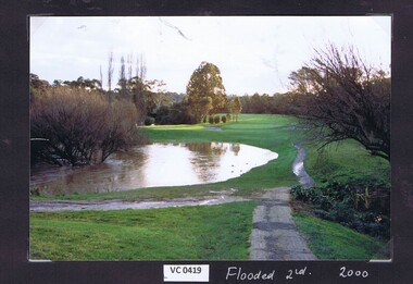
Photograph, Flooded 2nd fairway 2000: Heidelberg Golf Club, 2000
... Heidelberg Golf Club 8 Main Road Lower Plenty 3093 Flooded ...Flooded 2nd fairway 2000 at Heidelberg Golf Club.Colour photograph.hgc course, 2nd fairway -
 Heidelberg Golf Club
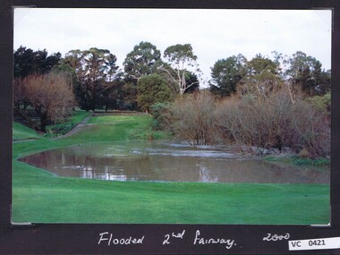
Photograph, Flooded 2nd fairway 2000: Heidelberg Golf Club, 2000
... Heidelberg Golf Club 8 Main Road Lower Plenty 3093 Flooded ...Flooded 2nd fairway 2000 at Heidelberg Golf Club.Colour photograph and caption.hgc course, 2nd fairway -
 Bendigo Historical Society Inc.
Newspaper - JENNY FOLEY COLLECTION: FEBRUARY FLOODS
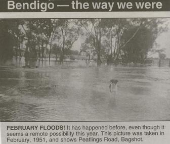
BHS CollectionBendigo Advertiser ''The way we were'' from Friday, February 6, 2004. February floods: it has happened before, even tough it seems a remote possibility this year. This picture was taken in February, 1951, and shows Peatlings Road, Bagshot. The clip is in a folder.newspaper, bendigo advertiser, the way we were -
 Bendigo Military Museum
Photograph - Royal Australian Survey Corps Surveyors in the Field – Project Cutlass, New Guinea, 1956 – 1957
This is a set of 23 photographs of surveyors and support staff in the field undertaking tasks in New Guinea 1956 – 1957. The surveyors were employed in the establishment of mapping and geodetic control for Project Cutlass, the “Ship-Shore” survey of the New Ireland province. In this survey operation surveyors used theodolites to observe horizontal and vertical angles and chains to measure base line distances between survey stations. Bob Skitch shown in photo .7P was in the 2nd year of his career in the Australian Army. He achieved the rank of Lieutenant-Colonel, and his last appointment was the CO of the Army Survey Regiment from 1976 to 1980.This is a set of 23 photographs of surveyors and support staff in the field undertaking duties during Project Cutlass located in New Ireland, New Guinea 1956 – 1957. The photographs were printed on photographic paper and are part of the Army Survey Regiment’s Collection. The photographs were scanned at 300 dpi. .1) - Photo, colour, 1956. Surveyors travelling main road from Kavieng to Namatanai, New Ireland. .2) - Photo, colour, 1956. Unidentified surveyors assessing recovery of their vehicle after bridge collapsed on west side of New Ireland. .3) - Photo, colour, 1956. Unidentified surveyors assessing recovery of their vehicle after bridge collapsed over flooded creek on west side of New Ireland. .4) - Photo, colour, 1956. Survey personnel L to R: Bev Uwins, John Lambie, Bob Thompson, New Ireland. .5) - Photo, colour, 1956. Survey base camp, New Ireland. .6) - Photo, black & white, 1956-1957. Geoff Helsham with possible human remains, New Ireland. .7) - Photo, black & white, 1956-1957. Bob Skitch undertaking survey observations using Wild T2 theodolite, New Ireland. .8) - Photo, black & white, 1956-1957. Chas Beach undertaking survey observations using Wild T2 theodolite, New Ireland. .9) & .10) - Photo, black & white, 1956-1957. Kev Parker (cook) New Ireland. .11) - Photo, colour, 1957. Brian Berkery taking a break, Top Manor Island, Lihir Island Group off New Ireland. Latitude -2° 46”, Longitude 152° 40”. .12) - Photo, colour, 1957. Survey base camp L to R: Chas Beach, Bev Uwins, Feni Islands, New Ireland. Latitude -4° 05”, Longitude 153° 45”. .13) - Photo, colour, 1957. A Hous Kiap. (Kiaps, known formally as district officers and patrol officers, were travelling representatives of the British and Australian governments), New Ireland. .14) & .15) - Photo, colour, 1957. L to R: Joe Farrington, Tom Royle Bob undertaking survey observations using theodolites from an improvised timber tower, New Ireland. .16) & .17) - Photo, colour, 1957. US Army ship FS216 used for ship-to-shore triangulation docked at Rabaul, New Britain. .18) - Photo, colour, 1957. US Army ship FS216 used for ship-to-shore triangulation docked at Kavieng, New Ireland. Sight target on top of mast. .19) - Photo, colour, 1957. Survey personnel onboard US Army ship FS392, L to R: Peter Frodsham, Bob Thompson, Doc Reid, John Underwood, remainder unidentified, New Ireland. .20) - Photo, colour, 1957. Survey base line party heading ashore, New Ireland. .21) - Photo, colour, 1957. Survey personnel rowing US Army assault boat L to R: Kev Parker, Chas Beach, folded up survey beacons overhanging stern, New Ireland. .22) - Photo, colour, 1957. Les Bailey onboard US Army ship departing Rabaul, New Britain for Brisbane. .23) - Photo, colour, 1957. Ron Newman onboard US Army ship departing Rabaul, New Britain for Brisbane. Active volcano in background..1P to .23P annotated on back – ‘Operation Cutlass’, personnel names, the year and the location. royal australian survey corps, rasvy, army survey regiment, fortuna, a, army svy regt, asr, surveying -
Clunes Museum
Photograph - PHOTOGRAPHS
23 X COLOURED PHOTOGRAPHS OF THE 2010 FLOODING OF CRESWICK CREEK IN CLUNES .1QUEENS PARK .2 BLACKMORE ROAD .3 BOWLING GREEN .4 LIGAR STREET .5 QUEENS PARK .6 TOWARDS BOWLING GREEN .7 QUEENS PARK .8 BOWLING GREEN .9 SENIOR CITIZENS .10 THE OVAL .11 33 ANGUS STREET .12 WATER CURRENTS .13 LOOKING TOWARDS FORMER TONY BAILEY'S HOUSE .14 ANGUS STREET .15 LOWER FRASER STREET .16 CORNER CAMERON STREETS - FLOOD PEAK AT 5PM .17 AT GOVERNMENT BRIDGE .18 LOOKING DOWN CAMP HILL .19 FORD .20 BUTTER FACTORY BRIDGE .21 BESIDE BOWLING GREEN .22 BUTTER FACTORY BRIDGE .23 DAMAGE AT FORD clunes floods 2010, creswick creek flood -
 Eltham District Historical Society Inc
Photograph - Digital Photograph, Alan King, Eltham Railway Trestle Bridge, 28 December 2007
Covered under National Trust of Australia (Victoria) State Significance and Heritage Overlay, Nillumbik Planning Scheme. Published: Nillumbik Now and Then / Marguerite Marshall 2008; photographs Alan King with Marguerite Marshall.; p103 The Eltham railway trestle bridge is the only one of its kind still regularly used in Melbourne’s metropolitan railway network. Opened in 1902, it is also one of Victoria’s very few timber rail bridges that still carries trains.1 The bridge is part of the railway line extension from Heidelberg - extended to Hurstbridge in 1912. This extension resulted in one of the greatest social changes experienced in Eltham Shire, as it considerably lessened its isolation attracting tourists, artists and suburban commuters particularly after World War Two.2 The bridge has been classified by the National Trust as historically, scientifically, aesthetically and socially significant at state level. But this has not always been recognised, and in 1977, locals fought to save it from destruction. The Victorian Railways proposed to replace the bridge with an earth embankment and large culverts to avoid maintenance problems and fire. This was rejected by the Eltham Council who protested that the bridge helped maintain the area’s rural character, historic link and beauty, as well as avoiding possible serious flooding on the flood plain if a culvert was blocked. The bridge stands as part of a National Trust classified landscape which includes the Alistair Knox Park, named after the local conservationist and architect who helped to make Eltham famous for its mud-brick houses. The landscape includes tall and spreading manna gums and candlebarks, and the historic Shillinglaw Cottage. Artist Walter Withers, one of the Heidelberg School of painters, painted the bridge early in the 20th century. The 38 span single-track railway bridge over creek and road has 34 timber-beam spans and four steel-joist spans, supported by four-pile timber piers and timber abutments. It has almost 200m of timber deck. All of the timbers have been replaced over the years, but the only change to the bridge’s character was the addition of pylons and wiring for electric trains in 1923. A petition for a railway to the shire was first made in 1883. A large deputation of local citizens to the Commissioner of Railways proposed a route passing through Alphington to midway between Greensborough and Eltham up the Diamond Creek valley towards Queenstown and Kinglake. As a result the Princes Bridge-Heidelberg Railway was opened in 1888. From 1888 locals demanded a railway extension. Kangaroo Ground farmers in particular, led by Shire Councillor and Member for Evelyn, Ewen Cameron, said it would assist local farmers and orchardists send their produce to the Melbourne market. In 1890, before the severe economic Depression, an extension of the line to Hurst’s Bridge (now Hurstbridge) was included in a new Railways Bill. The parliamentary delegations were regaled with a banquet at Hurst’s barn and entertained by the Diamond Creek Brass Band, but the extension was abandoned when the Depression struck in 1892-1893. The extension of the railway to Eltham, completed in 1902, was one of the few built in those hard times. That is why the Eltham timber-trestle railway bridge is a rare example of a broad-gauge rail bridge constructed between 1893 and 1910. At the opening, despite persistent drizzle, 300 children waving flags and banners were among the large crowd welcoming the first train, carrying official dignitaries, to Eltham. It had taken 24 years to bring the railway to Eltham. From then Eltham became a popular destination for outings. Mr Orford of Eltham recalled that after the railway came to Eltham ‘the craze for picnics on weekends and holidays began…. During the wattle season, wattle trains came to Eltham frequently. The visitors roamed the creek pulling great armfuls of wattle blossom to take back with them to Melbourne’.3 In 1926 the railway line was electrified as part of the metropolitan rail network. But the Victorian Railways decided not to complete the formerly planned Diamond Valley Railway to Queenstown (now St Andrews) and Kinglake.This collection of almost 130 photos about places and people within the Shire of Nillumbik, an urban and rural municipality in Melbourne's north, contributes to an understanding of the history of the Shire. Published in 2008 immediately prior to the Black Saturday bushfires of February 7, 2009, it documents sites that were impacted, and in some cases destroyed by the fires. It includes photographs taken especially for the publication, creating a unique time capsule representing the Shire in the early 21st century. It remains the most recent comprehenesive publication devoted to the Shire's history connecting local residents to the past. nillumbik now and then (marshall-king) collection, eltham railway trestle bridge, eltham trestle bridge -
 Melbourne Tram Museum
Photograph - Set of 5 black and white - Elizabeth St flood, Peter Duckett, 17-2-1972
Shows the impact of a major rain event near the Victoria Market and the former creek bed of Elizabeth Street acting as a drain. Cars floated and trams were damaged.Yields information about a major rain event in Elizabeth St during 1972 and the impact it had on vehicles and tramway operations.Set of five black and white photographs of major flooding in Elizabeth St 17-2-1972. Copied by the donor from negatives provided by the photographer.floods, elizabeth st, tramways, events, trams, melbourne -
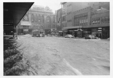
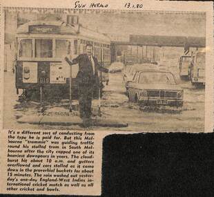 Melbourne Tram Museum
Newspaper, Herald Sun, Newspaper clipping re flooding in South Melbourne, 13-1-1980
Newspaper cutting about flooding in South Melbourne disabling a tram and a "trammie" conductor or driver, directing traffic. Tram W7 1019, route 10.Yields information about the type of delays that can occur on a big tram system.Newspaper cutting from the Herald Sun 13-1-1980 about flooding in South Melbourne and delaying tram W7 1019"Sun Herald 13.1.80"trams, tramways, tramcars, flooding, floods, south melbourne, w7 1019, route 10, crews -
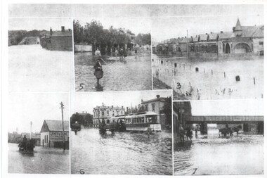 Melbourne Tram Museum
Photograph - Melbourne Flood scenes, 1910c
Composite photograph from a journal showing six flood scenes in the South Melbourne and Port Melbourne area - undated. Photo No. 6 has been identified as Crockford St Port Melbourne. The image with the bridge is possibly Montague St. The photo on the left with a horse drawn cart, has the factory of Jones and Dunn Furniture Manufacturers.Yields information about a flood in the Port Melbourne area.Composite photograph of flood scenes in Melbourne - undated.Melbourne – Floods in the suburbs, No. 6 Crockford St Port Melbourne. Copy neg Mark Plummer collections ex late John Alfred collection.cable trams, melbourne, floods, crockford st, port melbourne, bridges, south melbourne -
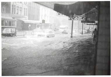 Melbourne Tram Museum
Photograph - Elizabeth St floods - Lonsdale St, Keith Kings, 17-2-1972
Photos shows the severity of the water washing down Elizabeth St following a major storm. Taken at or near the corner with Lonsdale St. In the second photo, W5 793, route 54, surrounded by water. Note the fruit vendors cart has crashed into a parked VW beetle.Yields information about a major rain event in Elizabeth St during 1972 and the impact it had on vehicles and tramway operations. Set of two Photographs - Elizabeth St floods - near Lonsdale St 1972Detailed description on rear. K S Kings stamp. tramways, flooding, floods, elizabeth sreet, events -
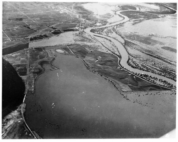 Merbein District Historical Society
Photograph, Merbein 1956 Floods, 1956
river road merbein, lake hawthorn -
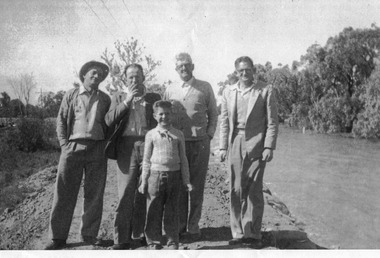
 Merbein District Historical Society
Photograph, Merbein 1956 Floods, 1956
... Merbein River Road - Pumps Merbein 1956 Floods Photograph ...merbein river road - pumps -
Merbein District Historical Society
Photograph, River Road 1956 flood, 1956
... River Road 1956 flood... Floods Murray River Flood 1956 River Road 1956 flood Photograph ...floods, murray river flood 1956 -
 Merbein District Historical Society
Photograph, Murray River flood River Road, 1956
... Murray River flood River Road... Murray River flood River Road Photograph ... -
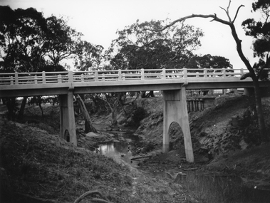 Stawell Historical Society Inc
Photograph, Greens Creek Bridge on the Wimmera River 1929
Greens Creek Bridge on the Wimmera River built in 1929 by C.R.B. and now demolished. The replacement bridge was designed to cope with the floods and the approaches to the new bridge were built up. This photo is a copy of a negative owned by the society.Black and white photograph of a concrete road bridge over a creek. Red gum trees in the background. Two concrete supports remain of old bridge on bank behind new bridge.stawell