Showing 581 items matching "gippsland rivers"
-
 Orbost & District Historical Society
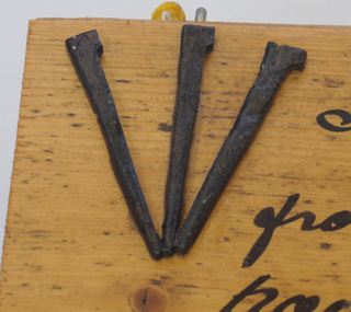
nails on board, 1885
These nails were made for Walter John Mundy (1868-1944). Often imported nails made for the softer English and North American timbers bent when hammered against the harder colonial woods and so The Mundy family were farmers / settlers in the Snowy River area since c. 1880s. The original Mundy family moved to a land "selection" at Betebolong in the early 1880's from Buchan. It's only over the past century or so that the mass-produced nail has become an inexpensive and common way to join materials. These three iron nails were hand made by an early Orbost settler or blacksmith in the 1880's, using iron, forge and anvil. They are examples of the types of nails used in the 19th century. A rectangular, wooden(athel pine?) board with three hand-made nails glued in fan design to top left corner of section of floorboard. There is a short length of yellow cord attached for hanging. To the right of the nails is hand-written text in black. the nails have irregular shanks and hammer marks on both shanks and heads.right of nails - " Flooring & nails from Walter Mundy's house at Jarrahmond built C.1885. Still in use to this day."mundy-walter hand-made-nails -
 Orbost & District Historical Society
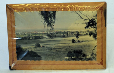
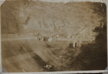
framed photograph, Orbost From "Grandview", mid 20th century
This photograph was taken from Grandview overlooking the Orbost flats.A black/white photograph in a frame. The frame has a stand. The frame is card padded over a metal frame. It is covered in plastic. The photograph is of the Orbost flats with the river and the town in the background.in white - "Orbost From "Grandview"grandview orbost-flats photograph -
 Orbost & District Historical Society
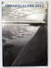
magazine, Croajingalong 2013, 2013
The name Croajingolong derives from the Australian Aboriginal Krauatungalung words galung, meaning "belonging to" and kraua, meaning "east". This is the sixty-sixth edition of the annual school magazine. Orbost High School / Orbost Secondary College has played a significant part in the education of senior students in the Orbost district . It is the sole senior educational institution. This magazine is representative of its history and is a useful reference tool.A glossy magazine titled " Croajingalong 2013". On the front cover is a photograph of the Snowy River at Marlo. On the back cover is the Orbost High School badge in various colours. It contains coloured photographs.magazine orbost-secondary-college education -
 Orbost & District Historical Society
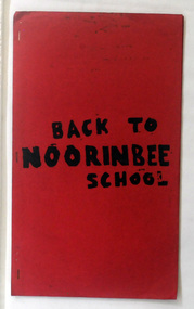
magazine, Back To Noorinbee School, 1974-1975
Noorinbee School, situated on the Bombala Rd approximately 6.5 km north of Cann River, was opened on 26th of July 1900, with Albert Le Page as head teacher until 30th of September 1904. The school still functions. A school bus runs daily to take the older children to the central classes at Cann River. "Noorinbee" is an Aboriginal word of unknown origin, The historical school is still at the front of the school yard. The Old Noorinbee School was been shifted twice. The first time they used a bullock team in 1924. The second time they used trucks and tractors in 1991. It was the first public building for the Cann Valleyand was first used as a hall and a church until it became the Noorinbee school in 1900. It was built in 1898. This item is a useful reference / research tool for the history of Noorinbee and its surrounds.A stapled paper back magazine with a red cover which has the title "BACK TO NOORINBEE SCHOOL" in black print. It contains a collection of articles relating to Orbost and Noorinbee and contains examples of children's work.noorinbee magazine-back-to-noorinbee-school -
 Orbost & District Historical Society
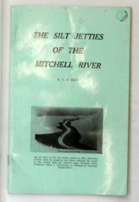
book, James Yeates & Sons (Printing) Pty Ltd, The Silk Jetties of the Mitchell river, 1972
This booklet was the first of a series of scientific and historical studies of Gippsland to be published by the Bairnsdale Advertiser. The author, Eric Charles Frederick Bird was Principal Fellow, Department of Geography, University of Melbourne, Australia. The Mitchell River silt jetties are an unusually long, thin landform located in the Gippsland Lakes region. They have been formed over millions of years by sediment deposition from the Mitchell River during periods of low water flow and subsequent wash-through during periods of high water flow. The long narrow banks of silt extend more than eight kilometres east into Lake King. This item is a useful reference for the silt jetties of the Mitchell River.A 32 pp book with alight green cover. The title is in black print, " The Silk Jetties of the Mitchell River" and underneath the title there is a b/w photograph of the Mitchell River and silt jetties taken from above in 1931. It was written by E. C. F. Bird.silt-jetties mitchell-river paynesville bird-e.c.f. -
 Orbost & District Historical Society
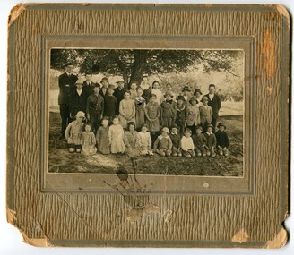
Photograph - Jarrahmond School & pupils c.1914
The Jarrahmond State School No. 2745 near Orbost was one of the earliest in this district. It opened in 1886 at the same time as Orbost and shared a teacher (Campbell McKay who was shortly afterwards replaced by John Rowe who stayed in this position until 1908). The building was financed and built by local farmers on the Stapley property. After a large and damaging flood in the nearby Snowy River in 1893 , the building was shifted to a new location. In 1926, a new building was constructed by the Vic Ed Dept. where it remained until the school was closed in 1948 and children from the Jarrahmond area were then bused to Orbost. Historical significance as one of the earliest photos of Jarrahmond School students.A b/w photo of a group of children and one adult in front of a tree. Children in the front are sitting on the ground, others are standing behind. Photo is mounted onto brown cardboard. On back of photo: Jarrahmond School c.1914. Sally Cole, Angus Cole.education, jarrahmond school, orbost -
 Orbost & District Historical Society
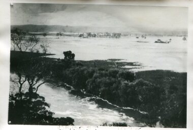
Photograph - Flood, Snowy River, Orbost 1978
... gippsland The Snowy River can flood over its floodplain at Orbost ...The Snowy River can flood over its floodplain at Orbost/Newmerella. There have been wet periods when floods were frequent and covered the floodplain, sometimes causing great disruption to crops and farming, and also to transport. The 1970s was a wet decade with many floods, the largest one in 1971. This photograph was taken in 1978. Evidence of flood on the Snowy River in 1978. A b/w photograph of a flood scene with trees and the river in the front, a river bank, and a vast area of water in the background. This photograph has been pasted onto a rough cardboard backing. Written below the photograph: Orbost 1978floods, snowy river, orbost -
 Orbost & District Historical Society
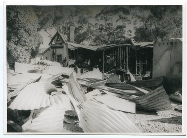
Photograph - Bemm River hotel fire
... gippsland Bemm River is a small township in East Gippsland ...Bemm River is a small township in East Gippsland. There have been several Bemm River hotels since 1891 when the first Hotel was built by Henry Summer. This Hotel was located near a ford where traffic crossed the river. Annie Morgan was the next person to have a roadside licence to sell liquor at Bemm River, also known as Sydenham Inlet Hotel. In 1927, a hotel was built on the present site at Bemm River, again with the Morgan family. Like many hotels, the Bemm River hotel has burned down or suffered damage through fires and was rebuilt. These photos are likely of a fire at the Hotel in 1994 which resulted in the hotel burning down. It was re-built in 2000 on the same site.History of Bemm River and its hotel5 b/w photos showing a building with severe fire damage, and two people in front of the photos (probably owners).nonebemm river, fire, hotels -
 Orbost & District Historical Society
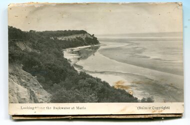
Postcard - Postcards, Marlo scenery
These photographs were part of a framed display in the kitchen of Orbost House, a guest house in McLeod Street, Orbost. historical record of Marlo township and surrounding estuary of the Snowy RiverTwo b/w photographs/postcards set on to backing board. These photos are of scenery at Marlo. Photographs appear to have been cut from a larger piece of cardboard, possibly a display board.2682.1 is titled LOOKING ALONG THE BACKWATER AT MARLO. 2682.2 is titled MARLO, EAST GIPPSLAND. Both have the marking of Bulmer, Bairnsdale (the photographer)marlo -
 Orbost & District Historical Society
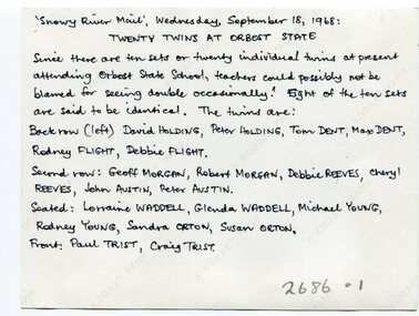
Photograph - Sets of twins at Orbost State School, 1968, 18 September 1968
The occurrence of 10 sets of twins at Orbost Primary School at one time was obviously a remarkable occurrence and has resulted in this special photograph being taken of the children. A remarkable photograph of a 'baby boom' at Orbost Primary SchoolB/W photograph of a total of 20 young children, some standing, some seated, wearing school uniforms. On back of photograph are the names of the children (see Media image 2686.1). Snowy River Mail Wednesday 18 September 1968. Twenty twins at Orbost State School. .............................orbost, orbost primary school, 10 sets of twins -
 Marysville & District Historical Society
Painting (Item) - Oil painting, Isaac Whitehead, A spring morning near Fernshaw 1880, 1880
A copy of an early oil painting of Fernshaw in Victoria.A copy of an early oil painting of Fernshaw in Victoria by Isaac Whitehead. Isaac Whitehead (1819–1881) was an Irish-Australian artist who worked in watercolour and pastel. He was also a picture framer and art promoter. It is believed that Isaaz Whitehead emigrated to Australia with his family in either 1853 or 1858. Isaac Whitehead died at his home 50 Punt Road, Prahran, Melbourne, on 21 April 1881. Isaac Whitehead had established himself as the foremost picture framer in Melbourne by 1860, known for his highly ornate frames with floral decorations. Among the clients of his framing business were Louis Buvelot, Nicholas Chevalier, and Eugene von Guérard. In his own paintings, he painted a number of scenes of the forests of Gippsland, Victoria. His work focused on the rich landscapes with trees and ferns, with a high degree of botanical detail. His work won him two medals and his work was posthumously exhibited at 1884 Victorian Jubilee Exhibition, the 1886 London Colonial and Indian Exhibition, and the 1888 Melbourne Centennial Intercolonial Exhibition. Fernshaw was a rural township 63 km northeast of Melbourne and 10 km northeast of Healesville. Situated on the Watts River, near where a log had fallen making a convenient crossing, Fernshaw was settled in the 1860s. It provided good country for orchards and berry growing. The location was at the foot of Blacks Spur, with Mounts Juliet and Mondah rising on either side, providing spectacular scenery. There were nearby fern gullies giving rise to the name – ‘shaw’ is old English for thicket or wood. By 1875 Fernshaw had a post office (1865), two hotels, a school (1871), and stores. It was famed for its beauty, attracting tourists. In 1886 the Melbourne and Metropolitan Board of Works began work on the Watts River water catchment scheme – later to become Maroondah – and the Board obtained approval for the catchment country to be reserved and kept free of settlement. This required the removal of the Fernshaw township, which was completed by about 1890.isaac whitehead, fernshaw, victoria, louis buvelot, nicholas chevalier, eugene von guerard, gippsland, victorian jubilee exhibition, london colonial and indian exhibition, melbourne centennial intercolonial exhibition, watts river, healesville, blacks spur, mount juliet, mount mondah -
 Federation University Historical Collection
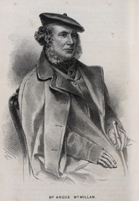
Drawing - Image - black and white, Angus McMillan, c1835
Angus McMillan named the Avon River after the river of the same name in his native Scotland. In 1840 he established a pastoral run at Bushy Park, north-west of the township. William Odell Raymond established a run in the area in 1842, and built his house, Strathfieldsaye, during 1848–54. European settlement did not take place without resistance, and in return, massacres were inflicted by Angus McMillan and others on Gunai people, especially between the years of 1840 and 1850. (wikipedia) The first application for the 'Bushy Park' run appears in the “Port Phillip Gazette” on 13 August 1843. It was taken up by Angus McMillan, who also took up the 'Boisdale' run for his employer Lachlan Macalister at the same time. In March 1844 a Licence to occupy the 16,000 acre 'Bushy Park' was granted to McMillan. In the late 1840s Andrew Martin and Matt McCraw built Angus McMillan's Bushy Park homestead. Aboriginal killings in Gippsland area most often were never formally recorded, but lived on in folklore, mainly in place names pinpointing what some historians now refer to as "massacres", and others as "conflicts". There is Boney Point, on Lake Wellington, Butchers Creek, near Metung, Slaughterhouse Gully, at Buchan, Skull Creek, at Lindenow, and, notoriously, Warrigal Creek, at Woodside. "Here, according to a couple of contemporary - though not eyewitness - reports, between 50 and 150 blacks were killed in an orgy of revenge after the murder and mutilation of a leading Scots settler, Ronald Macalister. If anybody had any doubts about the fitness of commemorating McMillan's name, no one voiced them then. Gippsland was, and still is, dotted with stone cairns tracing his route from Omeo, down the Tambo Valley to the fertile plains where he was to make (and lose) his fortune. And where, according to a growing body of opinion, he was to lead the "Highland Brigade", a band of armed settlers, against the Kurnai. History is fiction agreed on, and it is written by the winners. For most of the past 150 years, McMillan has been hailed as a trail-blazing pioneer. The legend began to crumble 20 years ago with publication of new histories, which at first outraged Gippsland historical societies and old residents, but which have gradually changed the way McMillan is viewed. ... Still, not all McMillan's contemporaries agreed with the "Highland Brigade" and its methods. Henry Meyrick, an English-born squatter, wrote to relatives in disgust about his neighbours. He estimated that 450 had been killed, and wrote: "Men, women and children are shot down whenever they can be met with. Some excuse might be found for shooting the men by those who are daily getting their cattle speared, but what they can urge in their excuse who shoot the women and children I cannot conceive." (http://www.theage.com.au/articles/2002/04/26/1019441303552.html, accessed 20 September 2016.) The Gippsland electorate is called 'McMillan' in his honour. Black and white image of a man wearing a coat and beret. He is Scottish born Victorian Squatter Angus McMillan of Bushy Park, Gippsland.angus mcmillan, squatter, aboriginal massacre, bushy park, gunai, avon river, pioneer -
 Federation University Historical Collection
Document - Reports, Large Cats, Thylacenes and Large Predators Sigtings, 1975-1985 and 2002-2011
The folder of correspondence is the result of a Freedom of Information request made to the Department of Sustainability and Environment in 2011. The folder was collected for research being conducted by David Waldron.Folder of correspondence and newsclips relating to "Big Cats" and other large predators. Please note: sections of this file are closed to protect the privacy of correspondents.australian mythical animals collection, david waldron, brian waters, moonambel, joyce collins, ian smith, thylacene, marrarkuli, burragorang, m.g. hornocker, mt bepcha, billywing upland, john a. henry, bryan wlaters, ken bodinnar, harcourt, kevin farley, fowlers bay, carolyn hodges, puma, macarthur, paynesville, john aldreson, animal damage control, mountain lion, bryan walters, cougar, big cat, maryborough, joan kirner, bernard mace, tasmanian tigers, d.g. willey, calder highway sightings, kevin phelen, mt richmond national park, feral cat, felis catus, lancefield, pyalong, broadford, pyalong pantherleopard, porsche park, dick shaw, big cats in victoria, peter hall, lyn sellens, south gippsland, plaster cast, foot cast, unidentified wildlife, john seeback, michael moss, carnivores, halls gap, halls gap puma scats, kooreh, ballan, ballan large cat, a.g. kerr, south gippsland tasmanian tiger sightings, central victorian puma, otways, wilsons promontory, john higgins, tasmanian wolf, j.k. depmster, vermin, lion, cooper's creek, warrego river, dingo, thylacinus cynocephalus, mirboo north, newham, operation puma victoria, australian skeptics, kangaroo ground, rare fauna, black wildcat, pyalong panther, bob warneke, black puma, maryborough puma, creswick panther, cape bridgewater, pyrenees panther, footprints, daisy hill, bung bong, phantom puma, geranium springs, maurice hornocker -
Federation University Historical Collection
Reports, Big Cats Sightings and Stock Kills 2000-2011, 2000-2011
... West wallaby creek south Gippsland Highway avon river orbost ...The folder or correspondence is the result of a Freedom of Informaition request made to the Department of Primary Industries in 2011. The folder was collected for research being conducted by David Waldron.Folder of reports of Big Cat by rangers. australian mythical animals collection, david waldron, department of primary industries, rangers, peter walsh, warragul creek, binginwarri, coongulla, straford, licola, blanket hill, darramin, blanket hill, woodside beach, heyfield, puma, panther, cowwarr, glenmaggie, bolands bluff, darrimen, bolands bluff, binginnwarri, dawson, the springs, mt taylor, black range, driffield west, snowy plains airstrip, glenmaggie north, jack smith lake, munro, briagaling, dutson downs, connors plain, giffard west, darriment, joyces road junction, giffard west, wallaby creek, south gippsland highway, avon river, orbost, four mile creek -
Federation University Historical Collection
Reports, Big Cat sightings (dates), 1989
Research of dated sightngs of Big cats in Victoria from 1868-1989. australian mythical animals collection, david waldron, dse, big cats, panthers pumas, nuggety, gippsland, black cats, tasmanian tiger, marysville, wood's point, thylacine, south gippsland, felid, gippsland big cat, kelvin healey, peter hall, sherbrooke forest, woodside, walaces flat, mountain lion, heyfield, mt taylor, walhalla, mt selma, warrnambool, kyneton, korumburra, canadian forest, grampians, panton hill, beaconsfield, apollo bay, forrest, victoria valley, rapanyup, dargo, inglewood, doncaster east, tidal river, cape bridgewater, walkerville, dooen, st arnaud, lake bung bong, mitta mitta, moliagul, emerald, kinglake, cape otway, dereel, leonard's hill, daylesford, korweinguboora, lal lal, noojee, eltham, lancefield, trentham, daisy hill, tanjil south, wonthaggi, cockatoo, warrenheip, greendale, howqua, lake buchan, melville caves, portland, mt elephant, morwell, navarre, yarram, yandoit, moonambel, maryborough, taravale, coghill's creek, trentham, carisbrook, inglewood, warrenmang, yarragon, creswick, emerald, stawel, clunes, majorca, heathcote, talbot, daylesford, newham, broadford, peter chapple -
Federation University Historical Collection
Booklet, E.J. Dunn, The Back Creek Silver-Lead Mine, near Buchan, Eastern Gippsland, 1905, 1905
Sixteen page booklet.gippsland, buchan, dickson's caves, basin creek caves, murrinfal river, wilon's caves, buchan limestone, mt tara goldfield, taedato creek gold workings, dominion copper mine, queen roeed, micawbet mne, surprise mine, good hope mine -
 Federation University Historical Collection
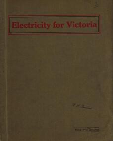
Book, Electricity for Victoria, 1927, 1927
Brown soft covered book. Contents include: Winning Brown Coal at Yallourn Dredge Operation for Overburden Removal Boiler Plant at the Yallourn Power Station Electrical Equipment at the Yallourn Power Station Steam Plant at the Yallourn Power Station Yallourn-Melbourne High Tension Line Yarraville Terminal Station Transmission distribution High Transmission Towers for River Crossing Sugarloaf-Rubicon Hydroelectric Development Briquette factory Subsidiary Activities at Yallourn Future Developments thompson's engineering & pipe co. ltd, briquettes, electricity, power generation, yallourn, yallourn briguetting works, transmission lines, high tension switchgear, insulators, australian porcelain company, substation, brown coal, high tension line, sugarloaf-rubicon, plans, suspension tower, transposition tower, yarraville terminal station, condenser, newport power station, gippsland, hydroelectric -
 Ringwood and District Historical Society
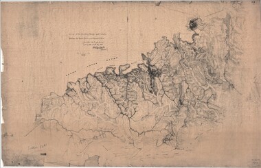
Map, Survey of Dividing Range between Yarra Yarra and Western Port - William Wedge Darke, 1843
Extract - Ringwood, Place of Many Eagles - Hugh Anderson (1974): William Wedge Darke, from Hereford, England, was a nephew of John Helder Wedge of the Port Phillip Association, who was also a surveyor. William's most important work was probably his survey of the Dividing Range and the country between the Yarra River and Western Port, completed in May 1843, and during which he made a traverse between the Mullum and Dandenong creeks along the higher ground that he labelled the "best line of road from Melbourne". This road was for many years the major route to Gippsland and to the higher country about Alexandra and Mansfield, sometimes known as White Horse Road, and now Maroondah Highway.Surveyor's relief map of features to the east of Melbourne including Yarra Yarra River, Mullum Mullum Creek, Anderson's Creek, Dandenong Creek.Transmitted to the Surveyor General with my letter of 10th May 1843 (signed) Wm Wedge Drake, Assistant Surveyor. Scale: two inches to a mile. Descriptive remarks include upstream area of Yarra River - "impassable, appears to have been formerly a lake", and to the south - "barren and scrubby swamps of the Western Port Country". Marked tracks include "best line of road from Melbourne", "track to Dandenong", "Road to Port Albert may probably be found on this range", "Best line to Upper Yarra". Several huts also marked. -
 Coal Creek Community Park & Museum
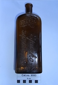
Bottle, glass, c. 1942-1951
TROVE : Weekly Times (Melbourne, Vic. : 1869 - 1954), Wednesday 17 June 1942, page 13 '…………… CHANDLER'S for Better Value!............ "SPARKO" SELF POLISHING WAX . . . . at 1/- large bottle…... (D. & W. CHANDLER LTD.) 276 BRUNSWICK STREET, FITZROY. J4145 (7 lines) 234 FLINDERS LANE, MELBOURNE. T4175 (4 lines) VICTORIA MARKET, BALLARAT. COLAC, HORSHAM, WANGARATTA, WARRNAMBOOL'. TROVE :Age (Melbourne, Vic. : 1854 - 1954), Saturday 15 September 1951, page 28 ‘…… TRAVELLERS calling on country stores in Victoria. We have an excellent line. Apply Sparko Speciality Sales Service, 17 Perry-street, Collingwood. JA3042. — TRAVELLERS, calling north of the river, we have additional lines, contact Sparko Specialty Sales Service, 17 Perry-street, Collingwood. JA3042……………………’ Brown rectangular bottle for stopper seal, with ridged pattern of ridges on both sides and back. Text embossed around base , on two sides at the shoulder, on the front side and on base.Embossed on rear shoulder 'POISONOUS NOT TO BE TAKEN', running around the four sides at bottom 'THE PROPERTY OF SPARKO SPECIALITY SALES SERVICE', on front at shoulder, a logo of a silhouette of Australia with a band diagonally across containing the word 'SPARKO'. on front running down the bottle 'Sparko Self Polishing Wax'. On base AGM logo, 'F451', 'D45', 'M. on edge of base '34A' in mirror text. -
 Coal Creek Community Park & Museum
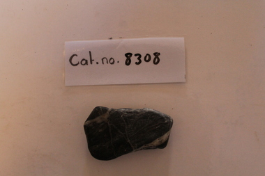
Black and white river stones
8308.1 - Flattened and overall rectangular; dark blue-grey layered mudstone with white veins of quartz showing multiple stages of secondary mineralisation. -
 Coal Creek Community Park & Museum
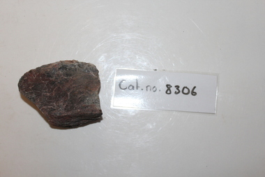
Bluestone fragment
largely unknown; ultimately originated as part of series of basaltic volcanic events across victoriaClearly a fragment of a river rock- one surface is smooth and curved the others planar. Mineralogy is basalt-"bluestone"-with white veins of secondary quartz minralisation -
 Coal Creek Community Park & Museum
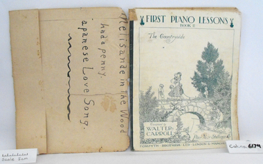
Music Book, First Piano Lessons, Book II, The Countryside
Music book "First Piano Lessons, Book II, The Countryside", Composed by Walter Carroll, covered in brown discoloured paper, original cover has a white background with charming illustration of children walking over stone bridge and fishing in the river, printed in blue.. -
 Victorian Interpretive Projects Inc.
Photograph - Colour, Alexander McMillan's Bushy Park near Maffra, 2014
... was located on the banks of the Avon River. Gippsland Maffra Bushy ...Alexander McMillan was a squatter and pioneer of Gippsland, Victoria. He called his run "Bushy Park" which was located on the banks of the Avon River.Colour photograph of the entrance to Bushy Park near Maffra.gippsland, maffra, bushy park, alexander mckinnon -
 Stratford and District Historical Society
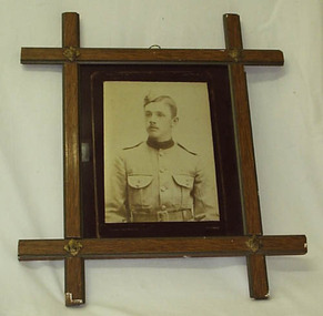
Photograph, Framed
The photograph that appears in this frame is a copy. The original is catalogued at 01314. Sgt David Hamilton Pruden, 404, enlisted from Newry and was killed at Koster River in the Trasnvaal on 21 July 1900, and was buried at Rustenburg cemetery. He is commemorated in a large tablet in the Stratford Mechanics' Institute. This photograph originally hung in the Stratford Mechanics' Institute. A framed sepia copy photographic print of a head and shoulders portrait of a young man in dress uniform of the Victorian Mounted Rifles, labelled Pte D.Pruden and presumed to be David Hamilton Pruden, who died in Africa during the Boer War. The frame, of crossed wooden bars with decorative metal at each crossing, appears to be commercially produced. Backing support for the frame is a section of an 1893 calender for an unknown insurance firm, agent J.B Kelly at Stratford, which has been detached for separate cataloguing.boer war 1899-1902 -
 Puffing Billy Railway
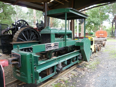
TACL - Erica State Sawmill Rail Tractor, 1928
TACL-Tractor Appliance Company Limited TACL rail tractors manufactured by Malcolm Moore of Port Melbourne Located in the Parishes of Moondarra and Telbit, Gippsland, the tramway terminated at Collins Siding on the Moe Walhalla 2'6"gauge branch of the Victorian Railways. Its construction by the Forests Commission of Victoria was to facilitate the extraction of timber from the Southern and Western slopes of Mount Erica and to replace the outlet tramways destroyed during the disastrous forest fires of February 1926. Tyers Valley Tramway The line, following the Eastern arm of the river, passed Ingrams Siding (7m.) to terminate at a forest area, known as "Ten Acre Block", 8m. 60c. from Collins Siding. The western branch of the line followed the Western Tyers Valley to Growlers Creek, 13m. 40c. from Collins Siding. THE T.A.C.L. TRACTORS at Tyers Valley tramway. On the 19th January 1928, T.A.C.L. locomotive, purchased from Tractor Appliance Co. Ltd. (Malcolm Moore), was delivered. This unit had a 20 h.p. Fordson engine coupled by a chain drive to the two axles, providing a tractive effort of approx. 2000lbs. Wheelbase was 5’ and weight was four tons. It was intended that the two tractor locomotives, working with the grade, would deliver timber from the branch lines to Tyers Junction, from which place it would be steam hauled out to the Collins Siding transfer point. Following a breakdown of the steam locomotive, haulage during the early months of 1928 was carried out by the T.A.C.L. unit, supplemented by the Nattrass, which was, by this time, becoming unreliable. During April 1928, after ensuring that no suitable locomotive was available in Australia, an order was placed with the Climax Manufacturing Co., U.S.A. for the supply of a geared locomotive. A second T.A.C.L. engine was purchased during May and, on the 27th, the local mill owners, having obtained running rights on the tramway, commenced haulage with the Harman. The three tractor units worked the branch lines and transported ballast, whilst the Harman hauled the timber to Collins Siding in rakes of eight trucks (56 tons). The weekly loading of the line for the first, second and third weeks were 54, 62 and 71 trucks respectively. info from : http://www.nmra.org.au/tyersvalley/Tyers-Tram.html Historic - Industrial Narrow gauge Railway - Timber working - Rail Tractor used by the the Forests Commission of Victoria on the Tyers Valley TramwayRail Tractor with Fordson engine coupled by a chain drive to the two axles - made of steel and wrought ironerica sawmill, puffing billy, tacl, rail tractor, tractor appliance co. ltd. (malcolm moore), industrial narrow gauge railway, tyers valley tramway, forests commission of victoria -
 Inverloch Historical Society
000554G - Photograph - Great Ocean Road, Cumberland River - C Newton
-
 Inverloch Historical Society
000554H - Photograph - Old and New Bridges of Dartmore river - C Newton
-
 Victorian Aboriginal Corporation for Languages
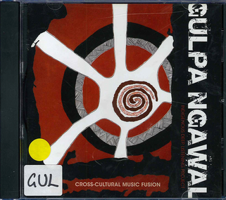
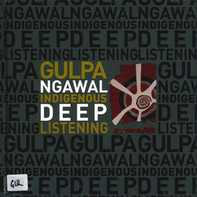
Audio CD, Laura Brearley et al, Gulpa ngawal : Indigenous deep listening, 2009
Introduction: In the Ngungikurungkurr language of the Daly River in the Northern Territory, the word for "Deep Listening" is 'Dadirri' (Ungunmurr, 2009) and in the Yorta Yorta language of the Murray River in Victoria, it is 'Gulpa Ngawal'. The closest we can get to describing it in English is deep and respectful listening which builds community. Deep listening draws on many senses beyond what is simply heard. It can take place in silence. Deep listening can be applied as a way of being together, as a research methodology and as a way of making a difference.CDsilcar, rmit, monash, koorie heritage trust, yorta yorta, taungurung, gunnai, gippsland, gunditjmara, richard frankland, deep listening, woolum bellum, education, art, music, indigenous research, sista girl productions -
 Victorian Aboriginal Corporation for Languages
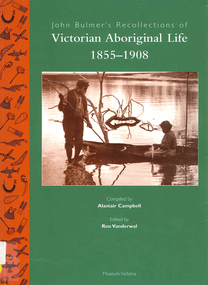
Book, Ron Vanderwal, John Bulmer's recollections of Victorian Aboriginal life, 1855-1908
John Bulmer spent forty years of his life as missionary to Aboriginal people in Victoria, in 1855 devoting his activities to communities on the Murray, but most of his life was spent at Lake Tyers where he established a Church of England mission in 1862, In his later years he wrote a series of thirteen papers in which he recorded his observations on the life and times of the people to whom he ministered. Over a period of several years Alistair Campbell transliterated the manuscripts, altering a little but retaining the flavour of the original text.maps, b&w photograph, word lists, tablesgunai kurnai, gippsland, lake tyers, lakes entrance, king charley, snowy river, ellen hood, sarah moffat, lance mcdougall, kassie mcdougall, tom foster, alec mccrae, nellie blair, john bulmer, victorian history, indigenous social life, kinship, religion and mythology, bush foods -
 Victorian Aboriginal Corporation for Languages
Book, Laura Brearley et al, Gulpa ngawal : Indigenous deep listening, 2010
Introduction: In the Ngungikurungkurr language of the Daly River in the Northern Territory, the word for "Deep Listening" is 'Dadirri' (Ungunmurr, 2009) and in the Yorta Yorta language of the Murray River in Victoria, it is 'Gulpa Ngawal'. The closest we can get to describing it in English is deep and respectful listening which builds community. Deep listening draws on many senses beyond what is simply heard. It can take place in silence. Deep listening can be applied as a way of being together, as a research methodology and as a way of making a difference.colour illustrations, colour photographsyorta yorta, taungurung, gunnai, gippsland, gunditjmara, richard frankland, deep listening, woolum bellum, education, art, music, indigenous research, sista girl productions