Showing 1315 items
matching growth
-
 Bendigo Historical Society Inc.
Document - PAPER ON: ''THE GROWTH OF METHODISM DURING 1850'S - 1890'S' ON THE (BENDIGO) GOLDFIELDS''
Fourteen paged Paper on ''The Growth of Methodism during 1850's - 1890's' on the (Bendigo) Goldfields'' by Lyn Barnes, Bendigo Tech College student 1980. While the Specific Interest Area is highlighted on page 1 as ''Mackenzie Street Church'' the paper covers a variety of topics - General comments about Methodism during the Gold Era (approx 2 pages); The Cornish Contribution (approx, 1 page); A Cornish man of particular note - James (Jimmy) Jeffrey (approx. 1 page); The Sandhurst Circuit (approx. 3 pages); Sandhurst Chinese Mission (approx. 1/2 page); Mackenzie Street Church (approx. 2 pages); Extract from letter from Rev William Butters to Rev W B Boyce, London (approx. 1 page); portraits of four Methodist Pioneers (1 page); ''Statistical Pages (1 page); Reference List (1 page).church, history, methodist, george eisfelder. rev john orchard, golden square wesleyan church, bible christian church long gully, rev w h hoskens, miss beryle buley. mr graydon grey. rev. william butters. mr walter powell. "california" taylor. -
 NMIT (Northern Melbourne Institute of TAFE)
Book: Melbourne’s North – the new knowledge economy Melbourne’s North – the new knowledge economy 2009
Melbourne’s North – the new knowledge economy is a study commissioned by NORTH Link and the Northern Metropolitan Melbourne Area Consultative Sub-Committee with seed funding from the Victorian Government Department of Innovation, Industry and Regional Development and matching funding from industry, education and local government in Melbourne’s North. It was prepared by National Institute of Economic and Industry Research. The report provides a detailed analysis of the Melbourne’s North regional economy and builds on the previous report, Growing Melbourne’s North – developing an integrated economy. It concludes that the region can achieve significant economic and social benefits if stakeholders share resources and cooperate across local government boundaries to form a discrete economic zone. The report includes recommendations and benchmarks that will support growth and quality employment outcomes for the region into the future as it undergoes the transition into a knowledge economy. Consultants National Institute of Economic and Industry Research (NIEIR), Carmine Consulting ISBN 978-0-9803994-4-3 northern melbourne region, nmit -
 Vision Australia
Administrative record - Text, Braille and Talking Book Library 90th Annual Report 1894-1984, 1984
Annual report of the Braille & Talking Book Library including Minutes of the AGM, Board of Director's Report, President's report and financial statements. Items also included are: the 8% decrease in salaries until December saved $28K, first issue of Brailletter magazine, 6 month delay for new borrowers to receive service, growth in loans and books from Maxene Hewitt Children's Collection, End of Year Party not held due to financial constraints but Children's Christmas party did proceed, Jan Smark invited to overseas workshops, Employment Initiatives funding used for cassette cataloguing and talking book maintenance, resignation of E. Haynes and Hector Bathurst, and appointment of Michael Zifcak and Don Schauder.1 volume of text and illustrationsbraille and talking book library, annual report -
 International House, The University of Melbourne
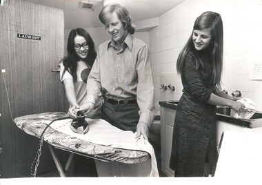
Photograph (Item), Students Felicity Ho and John Howie ironing, and Megan Edwards washing clothes in a Scheps Building laundry, 1972
This image brings together two major events in International House history in 1972, the opening of the Scheps Wing, and the admittance of women. Female students were initially accommodated on separate floors, and the Council has since attempted to maintain between 25% and 50% female students. The Scheps Wing was opened in May that year, named in honour of donors Theodor and Ida Scheps, its 92 rooms accomodating the growth of IH's diverse student body. John Howie was IH Student Club President from 1971-1972, the first permitted to regularly attend IH Council Meetings after years of petitioning for Council representation by the Student Club. Felicity Ho and John Howie, pictured ironing together here, later married."Photographed for publicity" inscribed in pen on reverse with names of subjects and datelaundry, scheps wing, students -
 Bendigo Historical Society Inc.
Book - AILEEN AND JOHN ELLISON COLLECTION: THREE DECADES
Book titled "Three Decades" Blue cover with gold lettering. On the front the emblem of the State Electricity Commission of Victoria 1921. The book has 192 pages. Three Decades - the story of the State Electricity commission of Victoria from its inception to December 1948. With a Foreword by The Hon. T. T. Hollway, Premier of Victoria. with 150 illustrations published by Hutchinson & Co. Ltd. First published March, 1949. Contents: Foreword - Chapter 1: The stage is set. Chapter 2: The commission is born - Chapter 3: Electricity from Yallourn coal - Chapter 4: Water power and growth to 1939 - Chapter 5: The war years and Kiewa - Chapter 6: Post war problems and rationing - Chapter 7: the spirit of Yallourn - Chapter 8: looking ahead organisation and finance - Chapter 9: Briquettes from Yallourn coal - Chapter 10: Transport, workshops, stores, purchasing - Chapter 11: The human side - Chapter 12: From power system to consumer - Chapter 13: Research, communications, regulations - Epiloguebooks, technical, electrical -
 Eltham District Historical Society Inc
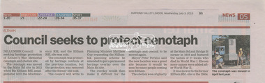
Folder, Eltham Cenotaph upgrade and heritage protection, 2013-2014, 2013-2014
Contents: Council seeks to protect cenotaph, Diamond Valley Leader, Wednesday, July 3, 2013, p5 Council defers RSL war memorial upgrade to seek consultation, Diamond Valley Leader, September 14, 2014 Future safe for war memorial, Diamond Valley Leader, Wednesday, November 13, 2013, p5 Plan to expand memorial; growth in ANZAC Day services inspires RSL proposal by Megan Bailey, Diamond Valley Leader, Wednesday, September 10, 2014 Residents say no to memorial upgrade; Mayor says feedback will be considerd at next meeting by Megan Bailey, Diamond Valley Leader, Wednesday, October 1, 2014 Memorial to be extended; expected to be finished before ANZAC Day ceremony by Megan Bailey, Diamond Valley Leader, December 17, 2014Six newspaper clippingseltham cenotaph, eltham war memorial, montmorency-eltham rsl sub-branch, war memorial garden -
 Federation University Historical Collection
Article - Article - Women, University of Ballarat: Women of Note; Heather Durant, Librarian at SMB, 1951-2005. (1933-2009)
Heather Durant (nee Walton) began as an Assistant Librarian at the SMB Campus in 1951. In December 1961 she resigned from the position due to her approaching marriage. No replacement was found so she returned in a "part-time position". She progressed to head librarian. Heather resigned again in 1962 and took a break for eight years. She then returned to the school. Combining the two periods of work she was employed for almost 50 years. During her time with the University of Ballarat she made an important contribution to the operation of the SMB Library. At times she was put in charge and worked to maintain library standards and collections through her work in library acquisitions and cataloguing. Over the years she witnessed the changes that occurred when technology was introduced and the growth of the University and TAFE divisions.women of note, teacher, ballarat school of mines, heather walton, heather durant, smb campus, librarian, resigned to marry, part-time work, library standards, and collections, acquisitions and cataloging, technology, 50 years service, 1951-2005 -
 Eltham District Historical Society Inc
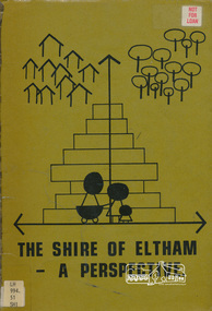
Book, Shire of Eltham, The Shire of Eltham - A Perspective, July 1981
This report was produced by the Shire of Eltham (Planning Department) following a population study of the Shire. It also includes other areas of general interest. The Document contents includes Present and Future - Population - Housing - Residential Lands - Social Characteristics - Development and History. Includes maps, tables and diagrams. Part 1: The Existing situation - introduction, the Shire of Eltham, physical characteristics, historical development, population growth. Characteristics of the population - size and distribution, age / sex, natural increase, migration. Socio-Economic Factors: socio-economic status, employment/workforce, education, other social factors. Housing/ building statistics: characteristics of Housing stock, current residential trends, other types of building activity. Residential Land: existing vacant lots, estimated additional lots. Part 2: The Future. Land availability, the future population.The Shire of Eltham Council resolved on publication of this report "to commend it to the ratepayers as a most valuable resource document". It provides a comprehensive statistical review of the Shire of Eltham, Victoria in 1981 with some population and development predictions for the future.Spiral bound, soft cover, includes indexBarcode and identification markings including stamped "WITHDRAWN" from Heidelberg Regional Library Serviceshire of eltham, planning, population -
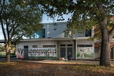 Yarra City Council
Artwork, other - Mural, Fiona McMonagle, The Park, 2022
'The first panel celebrates the long history of runners that use the park. Richmond Harriers Athletics Club was established in 1913 and is the oldest athletics club in Victoria. The central panel depicts young female footballers and recognises female athletes and the popularity of women and girls' teams in contemporary sports. The final panel depicts a children’s cricket match. The young players are represented through the depiction of a game that is part of our national psyche and firmly entrenched in Australian culture.'Inner-city parks like Citizens Park have many diverse uses. They provide places to play, to exercise and to relax. They are spaces for community and are often subject to competing values and interests. The re-development of the Jack Dyer Pavilion at Citizens Park allows for the growth of the local community’s diverse interests and values and enables participation and interaction. 'The Park' focuses on the recreational uses of Citizens Park and its role as a community space in an area that is changing rapidly. The mural consists of three panels that address inclusivity and access to sport. Three core sporting groups who each utilize the pavilion and park as a public recreational space are represented: children, sport teams and runners. In fostering the representation of these groups, the panels also attest to the past, present, and future of this important space.Three sporting groups are represented: athletics/runners, women footballers in line formation and young cricketers in action/play. Accompanying plaquesport, women, community, richmond, parks -
 Kew Historical Society Inc
Plan - Subdivision Plan, Camberwell Mountain View Estate, 1923
The Kew Historical Society collection includes almost 100 subdivision plans pertaining to suburbs of the City of Melbourne. Most of these are of Kew, Kew East or Studley Park, although a smaller number are plans of Camberwell, Deepdene, Balwyn and Hawthorn. It is believed that the majority of the plans were gifted to the Society by persons connected with the real estate firm - J. R. Mathers and McMillan, 136 Cotham Road, Kew. The Plans in the collection are rarely in pristine form, being working plans on which the agent would write notes and record lots sold and the prices of these. The subdivision plans are historically significant examples of the growth of urban Melbourne from the beginning of the 20th Century up until the 1980s. A number of the plans are double-sided and often include a photograph on the reverse. A number of the latter are by noted photographers such as J.E. Barnes.The so-called Camberwell Mountain View Estate was a subdivision on ‘the corner [of] Burke Road, Eyre and Wills Streets, Deepdene’. The Estate was not the first attempt to subdivide this land holding. In 1884, 1888 and 1894 the Belmore Park subdivision proposed 18 allotments for this parcel of land. The final stages of the Belmore Park subdivision occurred during the Depression of the 1890s. Apart from perhaps one block facing Burke Road, which is unnumbered in the Mountain View Estate subdivision, the rest must have remained unsold. The later subdivision would redraw the original 18 allotments, creating 22 new lots. In the Locality Plan on the left side of the subdivision plan, Deepdene Station, which formed part of the Outer Circle Railway is represented, as is the location of Deepdene Primary School. A selling point was the proposed extension of the Burke Road tram beyond its terminus at Cotham Road. The extension did not eventuate.subdivision plans - camberwell, mountain view estate -
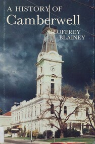 Surrey Hills Historical Society Collection
Book, A history of Camberwell, 1980
In 1964 Camberwell City Council commissioned Professor Geoffrey Blainey to first write this history. Since that time, many changes have taken place and therefore the Council asked Professor Blainey to bring the book up to date. Bibliography, includes index. The author presents a century of pioneering development and endeavours. He has traced the coming of the wood-cutters and the farmers, the transition from rectangular paddocks to a grid of roads and streets, the growth from shire to borough, town and city, the filling up of thirteen squares miles into residential suburbia - in successive waves of invasion, along new transport routes - including the Outer Circle Railway. Substantial chapters cover the War Years and the progress of Camberwell since the 1960s have also been included in this edition. 134p; ill;camberwell, victoria, market gardens, tolls, railways, mayors, boroondara road board, borondara shire, councillors, (mr) (prof) geoffrey blainey -
 Wooragee Landcare Group
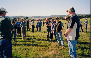
Photograph, 27 August 2004
This photograph was taken on Friday the 27th of August 2004 as part of an event called 'Direct Seeding Expo'. This event was one of many held by the Wooragee Landcare Group in the early 2000s which aimed to educate the local community on certain agricultural and biodiversity conservative techniques. This particular photograph shows attendees at the property of Neil and Anne Nankervis, inspecting sites where direct seeding had been used ten months earlier. Three different direct seeding techniques were demonstrated during the day by several experts in the field. Direct seeding involves the sowing of seeds directly into the soil to achieve germination and establishment. It is an alternative to planting seedlings in a contained nursery plot. This direct method is intended to mimic a more natural process of growth, revegetating larger areas in a more efficient manner.This photograph is significant as it provides evidence of a project undertaken by the Wooragee Landcare Group in the early 2000s to educate members of the public on alternative and potentially more efficient methods of planting seedlings. The Wooragee Landcare Group has been instrumental in the co-ordination of programs relating to biodiversity protection in the local area, providing great assistance to landholders.Landscape coloured photograph printed on gloss paperReverse: WAN NA EONA2N2. ANN+ 1 4240 / neil and anne nankervis, wooragee, wooragee landcare group, wooragee landcare, direct seeding expo, direct seeding, seeding, seedlings, direct seeding sites, alternative seeding, alternative seeding method -
 Federation University Historical Collection
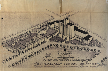
Plan, Ballarat School of Mines Future Development: A Southern Terminal to Lydiard Street, 1947, 09/12/1947
In 1947 Percy Everett, Chief Architect for the Victorian Government, drew up plans to accomodate the growth in student numbers on the Ballarat School of Mines site. It was an era of government buildings surrounding the Ballarat School of Mines campus either being transfered to the school or foreshadowed for transfer. In 1947 two Red Cross huts were transferred from Victoria Park to the western side of the former Ballarat Supreme Court (later Courthouse Theatre) for use by Wool Classing and Motor Mechanics. In the same year additional facilities were provided for Pottery due to the increase in enrolments and a large brick classroom was built at the rear of the Ballarat Junior Technical School Building. In the annual report of 1947 the President said: "These transfers are, however, only temporary expedients and indicate the pressing need for more buildings of a permanent nature". By the end of the year the School Council decided to request the Education Department of Victoria to proceed with the implementation of the School's long-range plan whch had received approval earlier and to treat it as an urgent post-war requirement. After much communication a plan for a six-storied building, flanked by two three storied buildings was planned to be built on the site of the Ballarat Gaol was developed. The plan was sent to the Education Department for the Minister's Approval. It is not know if approval was granted, but the building did not proceed, possibly becausse the Ballarat Gaol was still very miuch in use. When a tertiary division of the Ballarat School of Mines was being developed in 1967 it corresponded with the closure of the Ballarat Gaol. It was determined that the Lydiard Street South site had no room for future growth so a new campus was sought. The new campus was purchased at Mt Helen, and was initially known as the Ballarat Insittute of Advanced Education. In 1976, when the Ballarat Teachers' College merged into the structure, the campus became known as the Ballarat College of Advanced Education and it was no longer a part of the Ballarat School of Mines. Plans for a proposed building to replace the Ballarat Gaol buildings. The proposed building was never built, the concept being replaced by a new teritary facility at Mt Helen. buildings, percy everett, ballarat school of mines battery, ballarat technical art school, engineering workshops, machine shop, ballarat junior technical school, architectural plans, ballarat school of mines, smb campus -
 Bendigo Historical Society Inc.
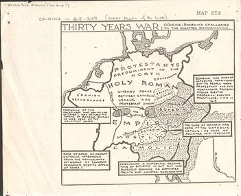
Document - GERMAN HERITAGE SOCIETY COLLECTION: MAPS OF GERMANY (PERIODS OF CHANGE)
Item 21. Maps of Germany (Periods of Change) held in two buff coloured commerce folders. Name written on the front in purple. Three loose copies of the Thirty Years War Map 21a, 21c and 21d. Maps of the Thirty Years War,Europe at the End of the 15th Century, The Reformation in Europe (16th Century), /Europe in the Time of Charles II & James II, The Domination of France 1660 - 85, Europe in the Time of Henry VIII, Germany in 1807 after reconstruction by Napoleon, German Federation 1815, The German Federation 1815, The German Empire of 1871, The Growth of the German Zollverein, Boundaries Before 1918 showing Kingdoms, Duchies, Provinces, etc., of the Former German Empire, the German Empire (1871 - 1918), and Boundaries before 1918 showing Kingdoms, Duchies, Provinces, etc., of the Former German Empire. The last page has a small map of Europe, a small map showing East and West Berlin, German Coats of Arms, Comparative International Figures of Population and a short article titled 'Do You Know Germany'.document, certificate, maps of germany, german heritage society collection - maps of germany (periods of change) -
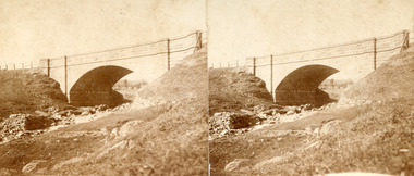 The Beechworth Burke Museum
Photograph - Stereoscopic Photograph, Unknown c1875
Depicted in the photograph is Newtown Bridge or the Newtown Falls Bridge, in Beechworth, Victoria. Noted for its location, detailed craftsmanship and stonemasonry by Scottish stonemasons the Newtown Bridge was built in the 19th century provincial town of Beechworth (completed in 1875). The bridge was built over Spring Creek, spanning 6.3 meters wide and 24.8 meters tall. Beechworth held a distinct role in the administrative and commercial management of Victoria's north-eastern goldfields, with many objects and structures still well preserved from the towns establishment. The bridge indicates the growth of the town, replacing a previous timber structure as well as its association to the mining activity in the area and the rapid increase in Australia's economy that led to investment and development of roads and railways. The local granite used in the construction of the single arch Newtown Bridge makes the bridge and other buildings made with the granite unique to the area, the honey-toned material distinct to Beechworth. This photograph is historically significant as it provides insight into the industrial development of Beechworth and the surrounding area, contributed to by the goldfields. The photograph further captures the representation of vernacular engineering traditions and Scottish stonemasonry.Two sepia-toned rectangular photographs featuring a bridge in the background printed on matte photographic paper mounted on card.Reverse: 97.2324/ Newtown Bridge/ Beechworthbridge, newtown beechworth, newtown bridge, newtown, beechworth, beechworth falls bridge, beechworth mining district, spring creek, -
 Kiewa Valley Historical Society
Photographs – Set of 10 black and white photographs and photocopies of original photographs documenting early residents of Bogong Village
Bogong Village, which was known as “The Junction”, is well recorded. The first tent camp was at the junction of Pretty Valley and Rocky Valley streams in the early 40’s. Further downstream were the sawmill, stables and blacksmith’s forge. Horses were the main mode of transport in the early days. The road to Bogong had reached the lookout spur just beyond Roper’s Spur track just before the 1939 fires. The early forties saw rapid growth of the village, with single and married men’s quarters, workshops, mess huts and administrative offices. The facilities necessary for communal living were quickly in place- a post office, police station, co-op store, medical centre, community hall/theatre, tennis courts and school. Much of the temporary accommodation that housed groups such as the Albion Quarrying Company were in the area now under water.This group of photographs are a pictorial record of the early history of the Kiewa Hydro Scheme, the people who worked in the background supplying administrative support and the workers and their families. It also shows a glimpse into how a large group of people from very diverse backgrounds came together to enjoy social activities and share each others companyGroup of 10 black and white photographs and photocopies of original photographs of varying sizes (some official SECV photos) Some Photos are labelled with the date and the names of SECV staff members. Depicting early life at Bogong Village 1. Group photo – Kiewa House Residents 1.8.41 (SECV official photo) 2. Female staff residents 3. Female office staff 4. Kitchen staff – Junction Mess (SECV official photo) 5. Male administration staff Bogong 6. Bogong Social Club fancy dress ball, 1940 7. Wives and children of SECV workers 8. Children in fancy dress 9. Opening of Volunteer Air Observers post 1943 10. Flag raising at opening of Volunteer Air Observers post 1. Printed under photo: STATE ELECTRICITY COMMISSION OF VICTORIA Date: 1.8.41 Time: 12.30pm No:K 435 Kiewa Hydro-Electric Works. Kiewa House Residents Back Row L to R: S.A. Salmon, W. Strachn, T.A Connors, W.J Norman, R.C Grealey, R.D Hegarty, Mrs Hegarty, W.R Morgan, S.A Clarke, P. Morgan, P.J. Harnetty, G.W Crouch. Front Row L to R: W.L Godfrey, R.S Hollands, Pte. R Charlesworth, R.L Dunn, N Caldwell, L.T Davies, I Webber, H.L Kendall, P Tiller, Ricky Hegarty, L.T Guy, M.C Cox, K.F Calder, D.S Gibson 2. Printed on bottom: Staff who lived at Kiewa House and worked in the Administration Office c 1943 Handwritten at bottom Priscilla Johnson (nee Reid) At top of page A GOOD LIFE: WOMEN’S RECOLLECTIONS OF LIFE IN THE UPPER KIEWA VALLEY 3. Printed under photo- Office Staff – Bogong 4. Printed under photo: STATE ELECTRICITY COMMISSION OF VICTORIA Date: 18.5.40 Time: 11.05am No:K 103. Kiewa Hydro-Electric Works. Kitchen Staff- Junction Mess. Opening night of the new staff mess Bogong. 5. Printed under photo -Administration staff Bogong 6. Printed under photo- The social club raised money for patriotic fund from fancy dress nights. (1st Fancy Dress Ball, Bogong 1940) 7. Printed above photo: ---- and family life begins (1942 Bogong) 8. Printed under photo: A favourite photograph 9. Printed under photo: STATE ELECTRICITY COMMISSION OF VICTORIA Date: 24.5.43 Time: 2.8pm No:K 1151 Kiewa Hydro-Electric Works. Bogong- Squadron Leader Leggett speaking at opening of Air Observer’s Post 10. Printed under photo: Raising the flag at the opening of the Volunteer Air Observer’s Post at Bogong - 1943 bogong village; kiewa hydro electric scheme; social activities; community clubs -
 Kiewa Valley Historical Society
Photographs – Set of 9 black and white photographs and photocopies of original photographs depicting the early days of Bogong Village during the 1940’s, circa 1940's
Bogong Village, which was known as “The Junction”, is well recorded. The first tent camp was at the junction of Pretty Valley and Rocky Valley streams in the early 40’s. Further downstream were the sawmill, stables and blacksmith’s forge. Horses were the main mode of transport in the early days. The road to Bogong had reached the lookout spur just beyond Roper’s Spur track just before the 1939 fires. The early forties saw rapid growth of the village, with single and married men’s quarters, workshops, mess huts and administrative offices. The facilities necessary for communal living were quickly in place- a post office, police station, co-op store, medical centre, community hall/theatre, tennis courts and school. Much of the temporary accommodation that housed groups such as the Albion Quarrying Company were in the area now under water.Pictorial history of the early years of Bogong Village including one photo taken following the devastating fires of 1939. Photos show the terrain in which Bogong Village was built, the early construction used for the temporary buildings and the housing and the amount of infrastructure required to accommodate the needs of the residents of the area including workers, their families and other support staff. Set of 9 black and white photographs and photocopies of photographs depicting early buildings at Bogong Village . Photos show very early construction buildings as well as the village in various weather conditions, including snowing and after bush fires. (some official SECV photographs) 1. Bogong Village in heavy snow 2. Bogong Township during heavy snow (SECV Official Photo) 3. VIP Lodge at Bogong in the snow 4. Bogong Village - circa 1940’s 5. Bogong Village under street lights 6. Lewis Construction Camp (SECV Official Photo) 7. Albion Quarrying Co. Camp (SECV Official Photo) 8. Tent camp and early buildings following 1939 fires 9. Typical house – Bogong Village 1. Handwritten under photo – August 1948 2. Printed under photo: STATE ELECTRICITY COMMISSION OF VICTORIA Date: 25.8.48 Time: 9am No:K 4680 Kiewa Hydro-Electric Works. Bogong Township 3. Handwritten on back of photo- V.I.P. Lodge, Bogong 4 – 5. No markings 6. Printed under photo: STATE ELECTRICITY COMMISSION OF VICTORIA Date: 28.11.40 Time: 1.40pm No:K284 Kiewa Hydro-Electric Works. Lewis Construction Camp 7. Printed under photo: STATE ELECTRICITY COMMISSION OF VICTORIA Date: 11.1.41 Time: 10.40am No:K294 Kiewa Hydro-Electric Works. Albion Quarrying Co. Camp – Bogong. Handwritten on back of photo: On the floor of the present dam 8. No markings 9. Printed under photo: STATE ELECTRICITY COMMISSION OF VICTORIA Date: 11.1.46 Time: 1.23pm No:K2181 Kiewa Hydro-Electric Works. Bogong – Typical House bogong village; 1939 fires; kiewa hydro electric scheme; -
 Warrnambool and District Historical Society Inc.
Medal, German Mothers Cross, Late 1930s
This item is a bronze German MotherCross. The MotherCross was given to German mothers of pure Aryan heritage before and during World War Two. Adolf Hitler wanted to encourage population growth and keep the German mother at home. Mothers were awarded these crosses according to the number of children they had – gold crosses for eight or more children, silver for six or seven children and bronze for four or five children. The crosses were presented to mothers on 4th August, the birthday of Hitler’s mother and also on Mother’s Day. They could only be worn on special occasions around the neck on a blue cord with two white stripes. This German MotherCross is a bronze one and has on one side ‘Der Deutschen Mutter’ and on the other side ‘16 Dezember 1938’ and Adolf Hitler’s signature. The date indicates when the award was first instituted. There were at least 8 million recipients of the medal.The recipient and donor of this medal are not known but it is a very interesting and unusual memento of World War Two.This is a metal medal in the shape of a cross with a bronze ridged background in the shape of a rectangle. The cross is enamelled in blue and white and has a round bronze disc in the centre and lettering with a blue swastika on a white background. There is lettering on the back of the cross. A metal catch is attached to the top of the cross and remnants of a blue and white cloth cord are looped over the catch. One small fragment of the cord is detached. The medal is in a box which is not the original container. ‘Der Deutschen Mutter’ ‘16 Dezember 1938’ plus Adolf Hitler’s signature world war two, german mothercross -
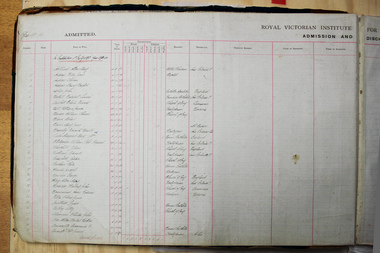 Vision Australia
Administrative record - Text, RVIB Admissions and Discharges register 1893-1967, 1893-1967
With the growth of the Institution, demographic details needed to be recorded along with basic client information This register contains the handwritten entries of registration number, date, name in full, year of birth date classification of gender and age range (5-10 years, 10-15, 15-25, 25-35 or 35 and over), religion, birthplace, previous address, cause of blindness, terms of admission, name and address of parent or guardian. Discharges were also recorded with the registration number, date of discharge, name in full, classification (same as above) and remarks. All entries are recorded according to the date of entry and at each financial year the number of indoor pupils, outdoor pupils and journeymen would be tallied. This register covers the period 1/7/1893 to 30/6/1967. Extremely limited name searching is available for this register, due to its poor condition.1 volume of handwritten entries into columnsroyal victorian institute for the blind, rvib burwood school -
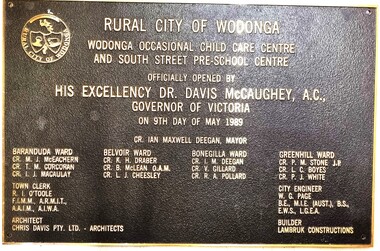 Wodonga & District Historical Society Inc
Plaque - Official Opening of the Child Care Centre & South Street Pre-School, Wodonga
This plaque commemorates the official opening of an occasional child care centre and pre-school in South St, Wodonga in 1989 by the Governor of Victoria Dr. Davis McCaughey. With strong population growth in Wodonga community services had expanded rapidly throughout the 1980s. The first child minding centre had opened in 1975. BY 1987 Upper Murray Family Care provided full-day family day care and occasional care and there were also 2 private child care centres. By 1986 there were 350 full-time places and 75 part-time places, but pre-schools were unable to fill the demand for another 511 applicants. This new facility helped to ease a little of the problem. As well as the inscription included here, the name of the Mayor, all members of the Wodonga Council, City Engineer, Architect and Builder are listed on the plaque.This item illustrates an important development in the provision of pre-school and child care services in Wodonga.A bronze rectangular plaque with detailed inscription, designed to be attached to the wall of a building. There is a hole in each corner for bolts to be inserted. The text is raised above the surface of the plaque. It features the symbol of the shield of the Rural City of Wodonga in the top left corner.fiction"RURAL CITY OF WODONGA WODONGA OCCASIONAL CHILD CARE CENTRE AND SOUTH STREET PRE-SCHOOL CENTRE OFFICIALLY OPENED BY HIS EXCELLENCY DR. DAVIS MCCAUGHEY, A.C., GOVERNOR OF VICTORIA ON 9TH DAY OF MAY 1989child care facilities wodonga, children's services wodonga, pre-schools wodonga -
 Wooragee Landcare Group
Photograph, 27 August 2004
This photograph was taken on Friday the 27th of August 2004 as part of an event called 'Direct Seeding Expo'. This event was one of many held by the Wooragee Landcare Group in the early 2000s which aimed to educate the local community on certain agricultural and biodiversity conservative techniques. This particular event took place across three different locations - Wooragee Hall, and direct seeded sites at the properties of Marcus and Lisa O'Connor, and Neil and Anne Nankervis - and, therefore, the exact location where this photograph was taken is unknown. Three different direct seeding techniques were demonstrated during the day by several experts in the field. Direct seeding involves the sowing of seeds directly into the soil to achieve germination and establishment. It is an alternative to planting seedlings in a contained nursery plot. This direct method is intended to mimic a more natural process of growth, revegetating larger areas in a more efficient manner. This photograph is significant as it provides evidence of a project undertaken by the Wooragee Landcare Group in the early 2000s to educate members of the public on alternative and potentially more efficient methods of planting seedlings. The Wooragee Landcare Group has been instrumental in the co-ordination of programs relating to biodiversity protection in the local area, providing great assistance to landholders.Landscape coloured photograph printed on gloss paperReverse: WAN NA EOWA2N2 ANN- 1 4240 / neil and anne nankervis, marcus and lisa o'connor, wooragee hall, wooragee landcare, wooragee landcare group, direct seeding expo, direct seeding, seeds, revegetation, alternative planting -
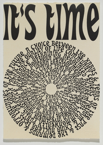 Merri-bek City Council
Relief etching printed in 1 colour from 1 copper plate over lithograph printed in 1 colour from 1 aluminium plate, Emily Floyd, It’s Time (Again), 2007
Emily Floyd is a Melbourne-based artist who works across sculpture, printmaking and public installation. In It’s Time (Again), Floyd graphically presents Gough Whitlam’s election speech, delivered before he became Prime Minster in 1972. Floyd’s training as a graphic designer is evident in the way in which the text’s presentation ties form to meaning. For example, the circular arrangement of the words resembles a vinyl record to be played again and again, implying the speech is worth revisiting. The circular arrangement also references other forms of timekeeping, such as the growth rings of a tree; the face of a clock; the cyclical nature of time, with its diurnal, lunar, seasonal and annual cycles. Floyd's work implies that social and political issues are cyclical in nature. It emphasises the necessity, once again, for proactive measures to ensure a quality, human-centered existence for everyone. -
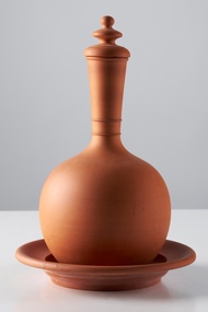 City of Greater Bendigo - Civic Collection
Domestic object - Water Monkey, Bendigo Pottery, 1880 - 1910
Vessels for storing water such as these are common throughout the ages and evident in the pottery of the middle east, Mediterranean and Africa. Between 1880 and 1910 Bendigo Pottery produced these as part of their terracotta ware range. Established by George Guthrie in 1857 (about 5km north of its current site) and then again seven years later in 1864 after it initially closed, Bendigo Pottery remains one of the most influential and longest running Pottery’s in Australia. Over the years the Pottery has contributed to the growth and development of the district through both its products including building products, table ware and decorative and commemorative war as well as artistically, being responsible for training and supporting many potters locally. The City of Greater Bendigo has had a long history of partnering with Bendigo Pottery to produce tourism tableware and art pieces and the Civic Collection holds a number of important items within its collection.Polished terracotta water holder with saucer and stopper. Globular body with rounded base. The shoulders taper into long cylindrical neck, no handle or pouring spout. Surface is undecorated expect for two rings at base of neck. This is the smaller of the two. 0430a stopper; 0430b vessel; 0430c saucerNone foundbendigo pottery, george gutherie, city of greater bendigo tourism -
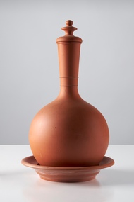 City of Greater Bendigo - Civic Collection
Domestic object - Water Monkey
Vessels for storing water such as these are common throughout the ages and evident in the pottery of the middle east, Mediterranean and Africa. Between 1880 and 1910 Bendigo Pottery produced these as part of their terracotta ware range. Established by George Guthrie in 1857 (about 5km north of its current site) and then again seven years later in 1864 after it initially closed, Bendigo Pottery remains one of the most influential and longest running pottery’s in Australia. Over the years the Pottery has contributed to the growth and development of the district through both its products including building products, table ware and decorative and commemorative ware, as well as artistically, being responsible for training and supporting many local potters. The City of Greater Bendigo has had a long history of partnering with Bendigo Pottery to produce tourism tableware and art pieces and the Civic Collection holds a number of important items within its collection.Polished terracotta water holder with saucer and stopper. Globular body with rounded base. The shoulders taper into long cylindrical neck, no handle or pouring spout. Surface is undecorated except for two rings at base of neck. This is the larger of the two. 0431a stopper; 0431b vessel; 0431c saucerNone foundbendigo pottery, city of greater bendigo tourism, george guthrie -
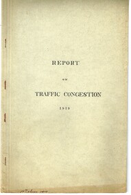 Melbourne Tram Museum
Document - Report, Road Board, "Report on Traffic Congestion", 1919
Report - 26 pages, printed, contained and stapled within a grey "Roneo Numeralpha System" folder, titled "Report on Traffic Congestion", containing a Victorian Parliamentary Report, dated 1919 with titled "Report of Board appointed to investigate the problem of relieving congestion of traffic in Melbourne." Full title "Report of Board Appointed to Investigate the problem of Relieving Congestion of Traffic in Melbourne" The Board or "Traffic Board" comprised 5 representatives of Councils, MMTB, Railways and the Public Works Department includes comments on growth of Melbourne, railways, tramways, new arterial roads, subways, new bridge at Spencer St, regulation of street traffic, looks at new tramway routes, hours works and provides a summary of recommendations including drawings for new arterial roads, graphs and roads / tramway layouts in two chain wide roads. Note: This document is available as a pdf on the Parliament of Victoria website. Second copy - unbound as printed, stapled on the left hand side, from McComb collection, box 10 - added 5/1/2017. added a 2nd copy from Russell Jones (28/05/22). Poor quality copy.Has in ink on the bottom edge "17th June 1919", Copy 2 - "H. Lormer"? in ink in the top right hand corner.trams, tramways, mmtb, general scheme, tramways, development, parliament, spencer st, railways, finances, construction, traffic control -
Glenelg Shire Council Cultural Collection
Tool - Anvil, Bradford and Kendall, n.d
Port of Portland Collection Bradken, originally Bradford and Kendall, began as a steel foundry in Sydney in 1920 and produced BK anvils at its factories in Alexandria and Mascot NSW. Leslie Bradford (General Manager) and Jim Kendall (Chief Mechanical Engineer), two BHP steelworks employees, got lucky at the races one day in 1920 and pledged their £15,000 winnings to start a steel foundry business. The horse they backed, ‘Jack Findlay’ completed a remarkable sequence of five wins during 1919 and 1920. With each win Leslie Bradford, Jim Kendall and a group of friends rolled-over their bets. By January 24, 1920 they had won a small fortune. On April 28 1920, the group used their winnings to establish the Alloy Steel Syndicate and build a steel foundry in Alexandria, Sydney to take advantage of what they saw as an untapped potential for industrial growth. Bradford Kendall Ltd was incorporated on 20th March 1922.Metal blacksmiths anvil. An anvil is used by blacksmiths to forge and shape his work pieces. The conical horn is used for hammering curved work pieces. The anvil is a common tool of the blacksmiths (‘smithies’) and other metalworkers. There has been very little change in the basic design of the anvil since Greek and Roman times. Blacksmith anvil, 5CWT, iron BK Sydney Australia.Front: 'BK SYDNEY AUST. 5CWT' Back: -port of portland, anvil, blacksmith, industry, bk anvil, bradken, brandford and kendall -
 Ararat Gallery TAMA
Mixed media, Inga Hunter, The Forest People Robe of the Keeper of the Pathwa, 1986-1989
“The Keeper of Pathways is a simple, secular office. Her job involves the maintaining of routes through and within the forests, and the lighting of night paths. She keeps a team of designers, workers and artificers, who must constantly strive to keep the wayrights free from invading undergrowth, so that they may admit safe and well-lit passage for all travellers. Not an exciting job, but one which is vital to communication between groups, and to the general safety of Forest dwellers. The forest paths (wayrights) are lit by strings of small lights made from a species of glowing fungus, which is specially cultivated in the mountain caves. A whole team of workers is responsible for the growth of the light fungus, taking shifts as a public duty. No Forest Dweller like caves, so the shift-work is shared out as a public service, one which each person must carry out at regular times, dictated by the clerks of the Keeper of the Pathways.”-Inga Hunter -
 Kew Historical Society Inc
Plan - Subdivision Plan, Balwyn Theatre and Shop Sites, circa 1927-28, c.1927-28
The Kew Historical Society's map collection includes a substantial number of real estate subdivision plans, mainly of Kew but also of surrounding suburbs in Melbourne. Most of the subdivision plans date from the 1920s and 1930s when the districts old homes and local farmland were being split up to accommodate residential growth in the postwar period. These early plans were assembled by a local firm, Jas R Mather & McMillan, which had an office in Cotham Road. Many of the plans, and sometimes photos, were annotated by the agents. The ‘new’ Balwyn Picture Theatre was built and owned by Balwyn Theatres Pty Ltd in ca. 1928. By 1930, this first Balwyn Theatre was destroyed by fire after a break-in. Following the fire, a new cinema was constructed. This plan for a Cinema and eleven shops presumably dates from 1927/28 when the Company announced that this location in Whitehorse Road ‘was the most central and best suited [area] for their Theatre and shops’.Subdivision plans are historically important documents used as evidence for the growth of suburbs in Australia. They frequently provide information about when the land was sold as well as evidence relating to surveyors and real estate and financial agents. The numerous subdivision plans in the Kew Historical Society's collection represent working documents, ranging from the initial sketches made in planning a subdivision to printed plans on which auctioneers or agents listed the prices for which individual lots were sold. In a number of cases, the reverse of a subdivision plan in the collection includes a photograph of a house that was also for sale by the agent. These photographs provide significant heritage information relating house design and decoration, fencing and household gardens.The photograph may also be aesthetically significant depending on the importance of the photographic atelier.Subdivision plan showing the Balwyn Theatre and its adjoining shop sites in Whitehorse Road Balwyn. The 11 shop sites were noted for their depth (133 ft - 145 ft. [Map.0041]balwyn theatre -- balwyn (vic.), subdivisions -- balwyn (vic), subdivision plans -
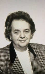
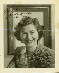 Kew Historical Society Inc
Photograph - Geraldine Ward, 1960
The East Kew Women’s Club was formed on 20 July 1945 as an experiment amongst local women, who felt that there was a need for some organised group to give full scope to their various interests and hobbies. In the beginning, they met at the house of their founder, Mrs Eric Thake, 48 Harp Road, East Kew, but the growth and interest was so rapid that it was soon necessary to find a larger meeting place, so the group moved to the Harrier’s Pavilion in Victoria Park, Kew. At the fifth meeting of the group, a committee was formed, and a constitution adopted on 4 December 1945.The Club was aimed to be non-political, non-sectarian and open to women from any locality. The Club’s motto was “To Help others, Improve Ourselves, and Foster the Community Spirit”. The first twenty years of the Club was recorded in a small, nine-page publication “East Kew Women’s Club : Twenty Years 20-7-1945 - 30-7-1965”.Portrait photograph of Geraldine Ward, signed, dated and addressed to the Ladies of the East Kew Women's Club.Obverse: [Signed in ink] For the ladies of the East Kew Women's Club with warm wishes, Geraldine Ward 1960." [Reverse annotated] Presented to Society with Minute Books from East Kew Women's Club. / Signed Geraldine Ward across photo / KH-217 / {Stamped] Hand Hasenpflug Illustrative Photography, 62 Swanston Street, Melbourne, Phone CENT 2187.clubs -- kew east (vic.), east kew women's club, glenda ward -
![East Kew Women’s Club: Twenty Years: 20/7/1945 [to] 30/7/1965](/media/collectors/550653872162f11fb04854aa/items/582d1076d0cdd12558de8ee9/item-media/58356ff7d0cdd10cccdd1152/item-fit-380x285.jpg) Kew Historical Society Inc
Kew Historical Society IncBooklet, East Kew Women’s Club: Twenty Years
The East Kew Women’s Club was formed on 20 July 1945 as an experiment amongst local women, who felt that there was a need for some organised group to give full scope to their various interests and hobbies. In the beginning, they met at the house of their founder, Mrs Eric Thake, 48 Harp Road, East Kew, but the growth and interest was so rapid that it was soon necessary to find a larger meeting place, so the group moved to the Harrier’s Pavilion in Victoria Park, Kew. At the fifth meeting of the group, a committee was formed, and a constitution adopted on 4 December 1945.The Club was aimed to be non-political, non-sectarian and open to women from any locality. The Club’s motto was “To Help others, Improve Ourselves, and Foster the Community Spirit”. The first twenty years of the Club was recorded in a small, nine-page publication “East Kew Women’s Club : Twenty Years 20-7-1945 - 30-7-1965”.Following the closure of the Club in 1973, after twenty-eight years, its records were deposited with the Kew Historical Society and are thus available for research into the history of women’s groups in the post war period in Australia. The Society holds the Club’s Minute Books of Meetings (1953-73), Attendance Registers (1959-73), Visitors Book, and sundry items of print ephemera published by the Club.Stapled self-published history of the East Kew Women’s Club, entitled - "Twenty Years 20/7/1945 - 30/7/1965". 9pp & covers.east kew women's club, community clubs -- kew (vic.) -- histories