Showing 504 items matching "gum tree"
-
 Phillip Island and District Historical Society Inc.
Photograph Album, Kodak, Phillip Island Cemetery, c 1889
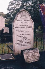
The Album was compiled by Nancy McHaffie late 1990's, with the assistance of Edith Jeffery's, with her book "Garden of Memories" and extensive knowledge of Phillip Island. The Cemetery lies back from the road and is surrounded by Manna Gums, rare Peppermint Gums, Blackwoods and other native trees. In all 25 acres of land were set aside as Crown Land in the land settlement of 1868. There are 6.2 acres of wetlands near the cemetery entrance.Captain McLeod: Captain McLeod and family kept the Post Office at Newhaven. He also built a boat called old "Trusty" and launched it almost opposite Churchill Island. Unfortunately, at a later date, the "Trusty" was the cause of a tragedy. The bottom of the boat had become so encrusted with marine growth that the owner decided to beach her between the jetties at Griffiths point, now San Remo. Before the job was completed the soring gave way and allowed the boat to tip over on her side, causing Captain McLeod to be crushed to death. Died March 3rd 1880 aged 64 years. Also buried in this grave is his wife Susan - died May 24th 1882 aged 62 years. Their son Andrew McLeod died February 21st 1916 aged 60 - loved husband of Elizabeth E McLeod. Alexander was Captain of the "Genista" for 12 years.phillip island cemetery, captain alexander mcleod, susan mcleod, andrew mcleod, nancy mchaffie, edith jeffery -
 Phillip Island and District Historical Society Inc.
Photograph Album, Kodak, Phillip Island Cemetery, c 1990
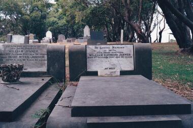
The Album was compiled by Nancy McHaffie late 1990's, with the assistance of Edith Jeffery's, with her book "Garden of Memories" and extensive knowledge of Phillip Island. The Cemetery lies back from the road and is surrounded by Manna Gums, rare Peppermint Gums, Blackwoods and other native trees. In all 25 acres of land were set aside as Crown Land in the land settlement of 1868. There are 6.2 acres of wetlands near the cemetery entrance.Two photos: a) Two graves - William Jenner & Elsie Myra Jenner. William died Oct 1957 aged 73 and Elsie died April 1968 aged 82. - William Raymond Jenner - son of William & Elsie - died Oct 1951 aged 42 years. b) Close up of William & Elsie grave. William had a farm at Ventnor, grew onions and chicory and was always willing to help out or lend any farming machinery. William was a member of the Ventnor School committee and Ventnor Hall committee. He was married to Elsie Churchill of Kilcunda and they had five children.phillip island cemetery, william jenner, elsie jenner, nancy mchaffie, edith jeffery -
 Phillip Island and District Historical Society Inc.
Photograph Album, Kodak, Phillip Island Cemetery, c 1990
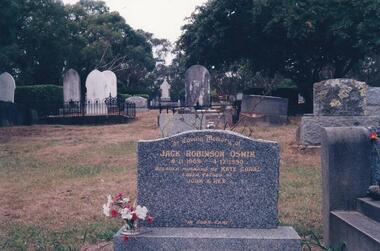
The Album was compiled by Nancy McHaffie late 1990's, with the assistance of Edith Jeffery's, with her book "Garden of Memories" and extensive knowledge of Phillip Island. The Cemetery lies back from the road and is surrounded by Manna Gums, rare Peppermint Gums, Blackwoods and other native trees. In all 25 acres of land were set aside as Crown Land in the land settlement of 1868. There are 6.2 acres of wetlands near the cemetery entrance.Jack Robinson Oswin: Many of the trees now flourishing in the cemetery grounds were planted by Jack Oswin and his wife Coral. Born in Mildura in 1909, his association with Phillip Island started when he attended the Cowes Primary School during the war years. He was foundation member of the Phillip Island Conservation Society and played a key role in the purchases of the area of land known as Conservation Hill. In the early 1980s he was awarded the British Empire Medal in recognition for his services to conservation. Jack died on December 4th 1990, aged 81 years.phillip island cemetery, jack robinson oswin, coral oswin, nancy mchaffie, edith jeffery -
 Phillip Island and District Historical Society Inc.
Photograph Album, Kodak, Phillip Island Cemetery, c 1990
The Album was compiled by Nancy McHaffie late 1990's, with the assistance of Edith Jeffery's, with her book "Garden of Memories" and extensive knowledge of Phillip Island. The Cemetery lies back from the road and is surrounded by Manna Gums, rare Peppermint Gums, Blackwoods and other native trees. In all 25 acres of land were set aside as Crown Land in the land settlement of 1868. There are 6.2 acres of wetlands near the cemetery entrance.The McKenzie Children: Late one night in 1934, Mr Bryant West and Mr Loton heard cries for help from the vicinity of the Cowes Jetty. Attempts were made to save a woman and the children. Sadly only the adult could be rescued. The three young bodies were later recovered and buried in the cemetery. Parents: Ronald & Ena McKenzie - Children: Ronald aged 5 years, Ena Roma aged 4 years and Douglas Forbes aged 1 year. phillip island cemetery, the mckenzie children, nancy mchaffie, edith jeffery -
 Phillip Island and District Historical Society Inc.
Photograph Album, Kodak, Phillip Island Cemetery, c 1990
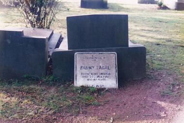
The Album was compiled by Nancy McHaffie late 1990's, with the assistance of Edith Jeffery's, with her book "Garden of Memories" and extensive knowledge of Phillip Island. The Cemetery lies back from the road and is surrounded by Manna Gums, rare Peppermint Gums, Blackwoods and other native trees. In all 25 acres of land were set aside as Crown Land in the land settlement of 1868. There are 6.2 acres of wetlands near the cemetery entrance.FANNY LAGAL (nee THOMPSON): Fanny arrived in Australia in the early 1920s. After her husband died she arrived on Phillip Island. She worked at "Summerland House" and later at the "Isle of Wight Hotel". She took great pride in keeping the altar linen and generally looking after the Anglican Church. Those who knew her said she was a gracious lady with a great sense of humour. Fanny went to a nursing home at Frankston where she resided until she died in February 1980, aged 90. Friends arranged for her to be buried at the Cemetery.phillip island cemetery, fanny lagal nee thompson, nancy mchaffie, edith jeffery -
 Phillip Island and District Historical Society Inc.
Photograph Album, Kodak, Phillip Island Cemetery, c 1990
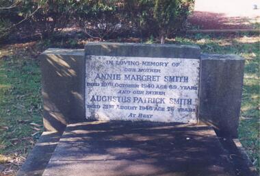
The Album was compiled by Nancy McHaffie late 1990's, with the assistance of Edith Jeffery's, with her book "Garden of Memories" and extensive knowledge of Phillip Island. The Cemetery lies back from the road and is surrounded by Manna Gums, rare Peppermint Gums, Blackwoods and other native trees. In all 25 acres of land were set aside as Crown Land in the land settlement of 1868. There are 6.2 acres of wetlands near the cemetery entrance.466-54: Annie Margaret Smith (nee Kearns) and Augustus Patrick Smith. Annie died in 1940 aged 69 years and was the wife of Augustus who died 1946 aged 76 years. He was the son of George Smith who arrived on Phillip Island about 1869. He paid 20 shillings per acre for 175 acres. 466-55: Margaret Jean Mallory. Margaret arrived on the Island in 1929 to teach at the Ventnor School. She became interested in community affairs and was the first to start the Girl Guides. She was President of the CWA and foundation member of the Golf Club. Margaret with her husband William (Bill), were tireless workers for the Children's Hospital along with many other worthy causes. Margaret died on November 25th, 1982 aged 75. William died February 1989 aged 87.phillip island cemetery, annie margaret smith nee kearns, augustus patrick smith, george smith, margaret jean mallory, william alfred mallory, nancy mchaffie, edith jeffery -
 Phillip Island and District Historical Society Inc.
Photograph Album, Kodak, Phillip Island Cemetery, c 1990
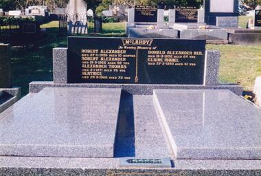
The Album was compiled by Nancy McHaffie late 1990's, with the assistance of Edith Jeffery's, with her book "Garden of Memories" and extensive knowledge of Phillip Island. The Cemetery lies back from the road and is surrounded by Manna Gums, rare Peppermint Gums, Blackwoods and other native trees. In all 25 acres of land were set aside as Crown Land in the land settlement of 1868. There are 6.2 acres of wetlands near the cemetery entrance.466-56: Alexander McLardy Sr. The descendants of Alex McLardy came to Phillip Island in the year 1886. A builder by trade, he built a great number of houses and buildings on the Island. He was also the founder of the Guesthouse "Glencoe". At 90 years of age he could still read well without the aid of glasses. He died in 1956 aged 95. Others buried in the double graves are: Robert Alexander died 1926 aged 10 months, Alexander Thomas died 1971 aged 76, Beatrice died 1966 aged 73, Donald Alexander died 1992 aged 64 and Claire Isobel died 1993 aged 61. 466-57: Walter Findlay. Walter's parents George and Mary, came to Australia in 1852. Walter was born in Sale circa 1883. He married Henrieta Kennon and they lived and farmed in Settlement Road, Cowes prior to their shop and residence being built in Warley Avenue, Cowes. The shop carried general merchandise and confectionery. The property was absorbed by Bass Coast Family Medicine on the west side of Warley Avenue. Henrieta died September 1965 aged 84. Walter died July 1965 aged 82.phillip island cemetery, alexander mclardy, walter findlay, nancy mchaffie, edith jeffery -
 Phillip Island and District Historical Society Inc.
Book, BEVERIDGE, Mitchell Kilgour, Gatherings among the gum-trees, 1863
... , Cleeland Bequest'. Gatherings among the gum-trees Book BEVERIDGE ...Labelled 'Cowes Free Public Library', 'Phillip Island Historical Society, Cleeland Bequest'.australia poetry, 19th century -
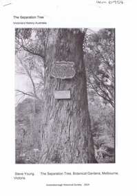
 Greensborough Historical Society
Photograph - Digital Image, Marilyn Smith, The Separation Tree Greensborough 2019, 02/07/2019
The original Separation Tree was one of two red river gums that pre-dated European occupation, and was the site where colonists congregated to celebrate the announcement of Victoria's separation from New South Wales on 15 November 1850. It died as the result of vandalism in 2010 and 2013. Saplings of the original were planted around Melbourne in 2014, including this one along the Plenty River Trail in Greensborough. The old aqueduct bridge can be seen in background.2 colour digital photographsseparation tree, plenty river trail, aqueduct pipe bridge greensborough -
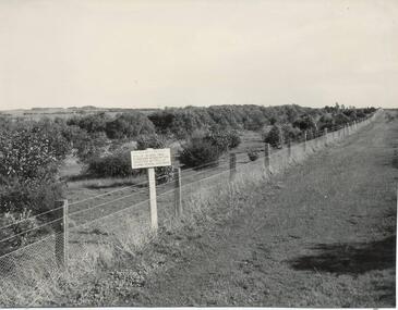 Phillip Island and District Historical Society Inc.
Photograph, Bryant West, 1959
... netting fence fronting Ventnor Road and showing ornamental trees... and showing ornamental trees with young Manna Gums behind. Photograph ...One of a collection of over 400 photographs in an album commenced in 1960 and presented to the Phillip Island & Westernport Historical Society by the Shire of Phillip IslandPhotograph of Ventnor Reserve looking north along the wire netting fence fronting Ventnor Road and showing ornamental trees with young Manna Gums behind.Notice in foreground...Planted by Phillip Island Tree Planters Association assisted by Phillip Island School Children.local history, photography, photographs, ventnor reserve, manna gums, john jenner, bryant west -
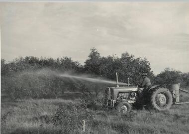 Phillip Island and District Historical Society Inc.
Photograph, Bryant West
One of a collection of over 400 photographs in an album commenced in 1960 and presented to the Phillip Island & Westernport Historical Society by the Shire of Phillip IslandPhotograph of F. Pickersgill on tractor with equipment spraying trees on the Ventnor Reserve.local history, photography, photographs, ventnor reserve - tree spraying, ventnor reserve, manna gums, tractor, spraying, f pickersgill, john jenner, bryant west -
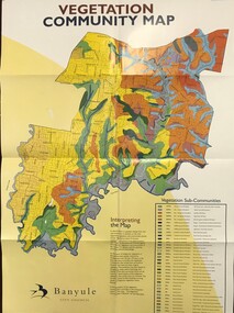 Greensborough Historical Society
Maps, Vegetation Community Map, 2000c
... vegetation gum trees Map & table, printed in colour both sides ...Map and table of indigenous vegetation 'communities' in Banyule. Map & table, printed in colour both sides, folded to A4banyule city council, flora, vegetation, gum trees -
 Greensborough Historical Society
Article, The Separation tree, 2019_
The tree was one of two original red river gums that pre-dated European occupation, and was the site where colonists congregated to celebrate the announcement of Victoria's separation from New South Wales on 15 November 1850. It died as the result of vandalism in 2010 and 2013. Saplings of the original are planted around Melbourne, including along the Plenty River Trail in Greensborough3 p. Wikipedia article; photograph of the tree in the Botanical Gardens, Melbourne (before it was vandalised), and copy of the document of separation of the province of Victoria from the Colony of New South Wales, owned by Colin Boucher..separation tree -
Glenelg Shire Council Cultural Collection
Photograph - Photograph - Rural scene with gums and water, horse standing near tree, n.d
Black and white photo mounted on heavy card. Rural scene with gums and water, horse standing near tree.Back: 'View near Portland' - black pen -
 Halls Gap & Grampians Historical Society
Photograph - B/W, C ?
This is the ford over the Stoney Creek and shelter shed.The photo shows a track leading down to a large pergola type structure, surrounded by thick bush. There is a tall gum on the right of the picture, beside the track. A large branch of a tree can be seen in the top left foreground.access routes, roads -
 Eltham District Historical Society Inc
Photograph, Monash Bridge, Arthurs Creek Road, Hurstbridge, Eltham Heritage Tour, 24 May 1992, 24/05/1992
ELTHAM HERITAGE TOUR The Society excursion on 24th May 1992 was arranged by David Bick, leader of the team carrying out the Shire's heritage study. David selected a number of sites or buildings identified in the study, some of them lesser known components of the Shire's heritage. The tour commenced at the Eltham Shire Office at 10.00 am. Travel was by private car and mini-bus with stops at about twelve locations for commentary by David.It included a short walk in Hurstbridge and lunch at Kinglake. Highlights of the tour included: - 10 am Leave from Shire Offices - 3 Important Trees - A Physical Link to Eltham's First Settlers - Toorak Mansion Gates - A Surviving Farm House - An Intact Circa 1900 Main Street - First Settlers - Gold Miners, and Timber-getters - An Early Hotel - A Pioneering Homestead - Changing Eltham Shire - 20th Century - 4 pm Afternoon Tea and Finish Tour Extract from ELTHAM CULTURAL HERITAGE TOUR (Newsletter No. 85, July 1992, by Bettina Woodburn) "On the Arthurs Creek Road is a bridge designed by Monash, which we admired before walking across the little park with a mud-brick and timber shelter, to the Hurst family graveyard. There are two marked graves, one, Henry who was shot by Burke the bushranger and a cairn has a plaque listing others buried here from 1866 onwards. Burke was captured and tied to the wheel of a dray under the eucalypt near the waterhose/standpipe. Close by the kindergarten, at this place are three trees on the National Trust Register, a Canary Island pine, a Canadian cedar and probably a spruce. Radiata pines and a thick bolled peppercorn surround the little cemetery. Continuing along Main Street we notice elm trees planted as a war memorial, then on the left a 1930 timber house, a 1910 store and residence, resplendent with wrought iron trim, a double fronted Hardware Store and cypresses on the back alignment of a new vacant block. On the right side of the street is a less interesting attempt at an 'in character' shop. Further on are more early homes, one tucked away at the rear with two tall palms by the front steps. Another curiosity is a rounded veranda corner and there are more galvanised iron sheds or garages, before a mud-brick Dentist's Surgery. Beyond the round-a-about is St Peters Church, of mud-brick construction shared by Catholic and Anglican parishioners, overlooking the river flood plain. Leaving Hurstbridge on the Kinglake Road, we ate our picnic lunch beside the communication tower and enjoyed views of Melbourne, Yan Yean Reservoir and the distant Dandenongs beyond the spreading suburbs. Next we drove to the North West boundary of the Shire at Masons Falls Road towards Whittlesea. On the way to the North East Boundary we passed St Peters, a yellow wooden Church with a Tudor Archway; built in the early 1920's in the style of the 1860's. From the Healesville-Kinglake road the rolling hills had European aspects, the hedged fields and chestnut trees. Then it was back down the Hurstbridge Road through 'Aussie' bush of towering gums, with bracken and scrubby understorey, the Kinglake National Park, before more open country with deciduous trees planted in line, and a creek lined with willows."Record of the Society's history and activities and highlighting various aspects of the Heritage Study undertaken by David Bick used to create the future heritage overlay for the Shire of Eltham and later Nillumbik Shire.Roll of 35mm colour negative film, 4 stripsKodak Gold 100 5095shire of eltham historical society, activities, heritage tour, hurstbridge, monash bridge, arthurs creek road -
 Kiewa Valley Historical Society
Photograph of Pretty Valley Workers Camp*, Pretty Valley Camp, circa 1949
Erection of staff quarters at Pretty Valley was completed in April, 1947 and accommodation for construction workers commenced in 1948 but suspended on 11th May for winter and resumed on 9th November. Construction of this camp was completed in 1949. A large dam was proposed at this site but was never constructed. Instead a small diversion dam was built which diverts water either to Rocky Valley Dam or to McKay Creek Power Station.An historical record of the type of accommodation provided for workmen during the construction of the Kiewa Hydro Scheme during the 1940's/50's.A black and white photograph of Pretty Valley Camp, c 1949. Dead trees are in the foreground, on both the left and right side of the photograph and a small snow gum is evident. There are camp huts and a much larger building behind these, possibly a workshop, and power poles are evident bringing electricity to the site.Handwritten in blue ink on back of photograph "Pretty Valley Camp. 5600 ft. above sea level".pretty valley, dam, water, workmen, camp -
 Eltham District Historical Society Inc
Photograph - Black and White Print, George W. Bell, Dead Red Gum, Eltham Templestowe Area
Black and white print on photo paper 35mm Black and white slide copy Mount - white 7 dots (Technodia Italy)george w bell collection, significant tree -
 Eltham District Historical Society Inc
Photograph, George W. Bell, Red Gum, Eltham-Templestowe area
Black and white photograph of dead redgum treetrunk near Fitzsimons Lane Elthamtrees, eltham, fitzsimons lane, george w bell collection -
 Cheese World Museum
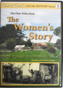
DVD, On our selection: the women's story
... is in the foreground, background has large cypress tree to left and gum... tree to left and gum to right. At the bottom is a series ...This is the story of the women of the bush, women who performed more than the traditional duties of wife and mother. They worked alongside their men, through good/times and bad and they were rare to complain. Six former country women of the Portland/Heywood district provide us with a snapshot of life as it was from the 1920's through to the 1960's. They speak about their own and their mother's lives, lives which have experienced the greatest material and personal changes in history. The story of the 'Remarkable Mary Stuchbery' details the struggles of a wife and family whose husband/father contracted polio shortly after returning from WWII service. Garry Kerr has produced a series of local history stories, initially for the Heywood [history group] and more recent items privately.The material contained in these interviews provides a first-hand insight into the experiences of women who were involved in carving farms from virgin bush. Their recollections of work, social activities and opportunities for their children are an invaluable primary source.Full colour DVD cover featuring image of old hip-roof weatherboard house with front verandah and skillion roof to rear with stone chimney attached to outside. Corrugated iron roof is rusty. To the left is an outbuilding. Picket and wire fencing is in the foreground, background has large cypress tree to left and gum to right. At the bottom is a series of three black and white images showing (L-R) three women in working clothes and a woman holding a baby; woman chopping wood; woman milking cow with young boy standing beside her. The back cover is yellow with images of the seven women featured showing coloured images of the interviewees beside black and white images of the interviewees when young. DVD features the same images as the front cover.Garry Kerr's LOCAL HISTORY Series 5/On Our Selection/The/Women's/Story/Produced by Garry Kerr (front) WOMEN WERE THE UNSUNG HEROES OF THE BUSH/This is the story of the women of the bush [see historical information] ... Running time 74 minutes/Plus an additional 30 minutes of/'The Remarkable Mary Stuchbery' -
 Marysville & District Historical Society
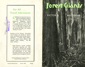
Ephemera (Item) - Information brochure, Victorian Government Tourist Bureau, Forest Giants Victoria Australia, 01-1938
An information brochure on where to see tall trees, Forest Giants, in Victoria, including Marysville, that was published in January, 1938.An information brochure on where to see tall trees, Forest Giants, in Victoria, including Marysville, that was published in January, 1938.Victorian Railways Print January, 1938 469-38 Stamp of Victorian/ Government Tourist Bureau/ 272 Collins Street/ Melbourne C.1victoria, australia, victorian government tourist bureau, betterment and publicity board, victorian railways, white mountain ash, red mountain ash, messmate, blue gum, mountain ash, cumberland valley, marysville, mount monda, healesville, acheron way, alpine highway, omeo, baw baws, strzelecki ranges, otway ranges, warburton, yarra junction, noojee, bulga and tarra valley park, yarram, turton's pass, otway forest, beech forest, apollo bay, information brochure, brochure -
 Eltham District Historical Society Inc
Photograph, Allwood, Hurstbridge, 1885
Allwood at Hurstbridge was named and first settled in 1837 by the Haley family. A house was built of one round of vertical slabs (red gum). Later it was the Hurst family home where Henry Hurst was shot by Burke the Bushranger on 4 October 1886. George Gray took over the property and the original home was eventually demolished. Gray, a fruit grower established an orchard and Allwood Nurseries which became a very successful business growing and exporting. This is probably around the time when this photo was taken where rows of fruit trees can be seen in the foreground. A house and associated buildings, possibly part of the nursery are behind. This photo forms part of a collection of photographs gathered by the Shire of Eltham for their centenary project book, "Pioneers and Painters: 100 years of the Shire of Eltham" by Alan Marshall (1971). The collection of over 500 images is held in partnership between Eltham District Historical Society and Yarra Plenty Regional Library (Eltham Library) and is now formally known as 'The Shire of Eltham Pioneers Photograph Collection.' It is significant in being the first community sourced collection representing the places and people of the Shire's first one hundred years.Digital imagesepp, shire of eltham pioneers photograph collection, diamond creek, hurstbridge, allwood, orchard -
 Eltham District Historical Society Inc
Photograph, Large River Red Gum, Stawell Road, Lower Plenty; Autumn Excursion to Lower Plenty area, 18 April 1998, 18/04/1998
... melbourne activities lower plenty stawell road trees river red gum ...Roll of 35mm colour negative film, 2 stripsKodak Gold 200-6activities, lower plenty, stawell road, trees, river red gum -
Glen Eira Historical Society
Article - Vegetation
Four items pertaining to vegetation within Caulfield: 1/2 copies of a booklet produced by the Caulfield City Council (undated) offering residents advice on the planting and care of trees within the district. Contains seven black-and-white photographs portraying various spots of vegetation within the district, plus nine black-and-white cartoons portraying the steps involved in correctly planting a tree. 2/An article from the Caulfield Contact, dated 04/1992, pertaining to Caulfield’s indigenous vegetation. Contains three black-and-white photographs of portraying three species of said vegetation – the swamp gum, the Kangaroo Apple and Poa grass. 3/An article from the Southern Cross, dated 13/05/1992, pertaining to Caulfield’s indigenous vegetation, and the efforts of groups and individuals such as the Caulfield Environment Group (CEG) to preserve it. Contains a black-and-white photograph of CEG member Paul Cain with a Red River Gum and large tussock grass, part of a re-vegetation program in a Murrumbeena linear park. 4/ A clipping from the Southern Cross, dated 20/05/1992, pertaining to the presence of Murray River red gum at Elsternwick primary school. Contains a black-and-white photograph of two pupils of the school, Craig and Emelia (surnames unmentioned), planting saplings.caulfield, plants, trees, caulfield city council, gardening, horticulture, landscape planning, caulfield contact, outer circle parklands, caulfield environment group, cain paul, smith colin, joint effort community house, outer circle railway, conservation of natural resources, murrumbeena, parks, minister for conservation, pullen barry, glenhuntly neighbourhood house, primary schools, elsternwick primary school, murphy street, mcinerney peter, elster canal -
 Federation University Historical Collection
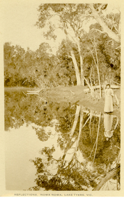
Postcard, Howard D. Bulmer, Reflections, Nowa Nowa, Lake Tyers, Victoria
Nowa Nowa is located in Victoria on the Princes Highway between Lakes Entrance & Orbost. Tall eucalypts stand guard as you drive into this small village.The fresh waters of Boggy Creek and the tidal waters of Lake Tyers meet here. In the past its history was of logging. Black and white post card showing a lady in long skirt standing on the banks of a river with Australian eucalypts (gum tress) in the background and reflected in the water. nowa nowa, lake tyers, trees, river -
 Federation University Historical Collection
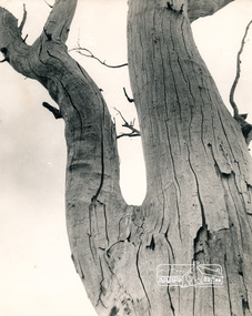
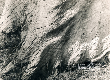
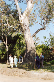
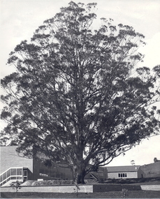
Photograph - Photograph - Black and White, The Tree of Knowledge, c1979, c1979
... tree blue gum Mount Helen Campus Photograph of the 'Tree ...The 'Tree of Knowledge' was planted on Arbor Day 1896 by Mrs Elizabeth Downing who lived on the farm that was originally the Mount Helen Site. When the site was purchased in 1966 the architects and planners inspected the site and decided 'The Big Tree' must remain as a central landmark in preparing the layout of the campus.Photograph of the 'Tree of Knowledge', a Tasmanian Blue Gum (Eucalyptus glubulus labillo), located at the Mount Helen Campus of Federation University. The tree is registered by the National Trust,federation university, federation university australia, feduni, university of ballarat, mount helen, tree of knowledge, big tree, blue gum, mount helen campus -
Federation University Historical Collection
Booklet, Charles Barrett, The Sun Tree Book - Sun Nature Book No. 8, 1936
Paperback booklet with trees printed on front cover and advertisement for Rimington's Nurseries on the backcover. 44 pages. The book included a foreword from A.V. Galbraith, Chairman of the Forests Commission of Victoria.trees, botany, plants, grey box, gum nuts, elms, conifers, currajong, atlantic cedar, western yello pince, stone pine, deodar, bunya bunya pine, sequoia, wattle, black wattle, blackwood, cumberlad valley, banyan, jungle fig, lombardy polar, honysuckles -
 Bendigo Historical Society Inc.
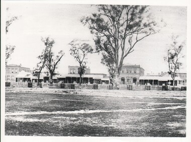
Photograph - WES HARRY COLLECTION: PALL MALL, SANDHURST, Early 1860's
Photograph of a section of Pall Mall, Eastwards from the corner of Bull Street. Some of the businesses visible are : Freemasons (hotel?), outfitters, Monster sale of Drapery, C. Huxtable, Saddlers, In The foreground there are numerous tree guards as well as several large Red Gumsplace, streetscape, pall mall, pall mall, freemasons, c, huxtable, bianchi -
 Buninyong & District Historical Society
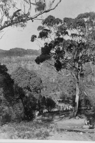
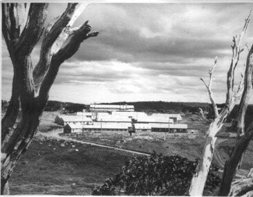
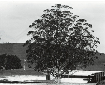
Photograph - B/W photograph, 1970
... Education Green Hill Mount Helen University Trees Tasmanian Blue Gum ...Early photograph 1970 showing first buildings of Mount Helen Campus of Ballarat University built on early estate near Green Hill. The Tasmanian Blue Gum featured dates from 1896Significant tertiary institution established in the historical pastoral area of Green HillBlack and white photo of early buildings of Mount Helen Campus of University of Ballarat featuring significant Tasmanian Blue GumTasmanian Blue Gum with Civil Engineering building and Green Hill in the background 1970education, green hill, mount helen, university, trees -
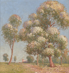 Benalla Art Gallery
Painting, W. LISTER LISTER, Flowering gums, Not dated
Born: Manly, New South Wales, Australia 1859; Lived and worked: England 1884-1888; Died: Sydney, New South Wales, Australia 1943ImpressionismGift of Wooleen Pty. Ltd., 1980Treed path leading up to top of hill and building. Bronze brushed timber frame.Recto: Signed "W LISTER LISTER" in brown oil in l.r.c of composition; Not dated; Not titledpainting, trees, building, landscape, path