Showing 1133 items matching "kew east"
-
 Kew Historical Society Inc
Photograph, City of Kew, City of Kew, Cecil Street Drain, 1936
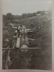
... of the photographs are of Studley Park, Kew or East Kew, each photo provides... are of Studley Park, Kew or East Kew, each photo provides a fine snapshot ...An original photograph donated to the Kew Historical Society by the City's Engineering Department following the amalgamation of Kew into the City of Boroondara. While not all of the photographs are of Studley Park, Kew or East Kew, each photo provides a fine snapshot of the work of local government engineering departments of the period. They reveal they types of labour conducted, the techniques used and the equipment and machinery in the possession of the local government authority. Historic and rare photograph of major public works in Kew in the 1930s.Public works. Men at work in the creek bed of Connor's Creek in Kew, while constructing the underground drain. Connor's Creek was one of the two main tributaries of the Yarra River in Kew. It originated somewhere near the grounds of Genazzano FCJ College. The barrel drain was finally completed in 1941 at a cost of £14,000. Inscription on reverse: "City of Kew / Cecil st drain / November 1936". city of kew, city of kew (engineering department), engineering, connor's creek (kew) -
 Kew Historical Society Inc
Photograph - Flood at Fairfield Park, 1934
... of the Yarra bordering Kew and Kew East in the north and west... bordering Kew and Kew East in the north and west of the municipality ...Flooding of the Yarra Valley, including that section of the Yarra bordering Kew and Kew East in the north and west of the municipality, was a regular occurrence. Extreme flood events of the Yarra River are recorded to have occurred in 1891, 1901, 1916, 1923 and 1934. The Municipality of Kew's response to these floods was to enact planning decisions restricting residential development in flood prone areas following the floods of 1916, 1921 and 1934. While floods continued after the development of the Upper Yarra Reservoir (construction 1948-57), the regularity and extent of these inundations diminished.Black and white print positive. Yarra River at Fairfield in 1934. Major flood resulting in submerged buildings in middle ground and onlookers on far bankReverse: "Flood of Yarra at Fairfield Park 1934"fairfield park, yarra valley, river yarra, floods -- 1934 -
 Kew Historical Society Inc
Photograph - Yarra in Flood, 1934
... of the Yarra bordering Kew and Kew East in the north and west... bordering Kew and Kew East in the north and west of the municipality ...Flooding of the Yarra Valley, including that section of the Yarra bordering Kew and Kew East in the north and west of the municipality, was a regular occurrence. Extreme flood events of the Yarra River are recorded to have occurred in 1891, 1901, 1916, 1923 and 1934. The Municipality of Kew's response to these floods was to enact planning decisions restricting residential development in flood prone areas following the floods of 1916, 1921 and 1934. While floods continued after the development of the Upper Yarra Reservoir (construction 1948-57), the regularity and extent of these inundations diminished.Black and white print positive. 1934 floods of the Yarra Valley. Location Fairfield looking towards wooded hillside. Houses floating in river.Reverse: "From Fairfield Park (11936?) back towards hill (Wurundjeri Spur?)"floods -- 1934, yarra valley, yarra river, fairfield park -
 Kew Historical Society Inc
Photograph - River Yarra in Flood from Kilby Road
... of the Yarra bordering Kew and Kew East in the north and west... bordering Kew and Kew East in the north and west of the municipality ...Flooding of the Yarra Valley, including that section of the Yarra bordering Kew and Kew East in the north and west of the municipality, was a regular occurrence. Extreme flood events of the Yarra River are recorded to have occurred in 1891, 1901, 1916, 1923 and 1934. The Municipality of Kew's response to these floods was to enact planning decisions restricting residential development in flood prone areas following the floods of 1916, 1921 and 1934. While floods continued after the development of the Upper Yarra Reservoir (construction 1948-57), the regularity and extent of these inundations diminished.Print copy of an original photo of the River Yarra in Flood, taken from Kilby Road.VIEW ACROSS YARRA IN FLOOD / FROM KILBY RD KEWkilby road, floods -- kew (vic.), kilby farm -
 Kew Historical Society Inc
Collection, Floods in North Kew (Series), 1929–1934
... of the Yarra bordering Kew and Kew East in the north and west... bordering Kew and Kew East in the north and west of the municipality ...Flooding of the Yarra Valley, including that section of the Yarra bordering Kew and Kew East in the north and west of the municipality, was a regular occurrence. Extreme flood events of the Yarra River are recorded to have occurred in 1891, 1901, 1916, 1923 and 1934. The Municipality of Kew's response to these floods was to enact planning decisions restricting residential development in flood prone areas following the floods of 1916, 1921 and 1934. While floods continued after the development of the Upper Yarra Reservoir (construction 1948-57), the regularity and extent of these inundations diminished. Natural disasters had an impact on the development and settlement of Melbourne and its suburbs. Flooding in the Melbourne region was a regular event in the nineteenth and for most of the twentieth centuries. Changes in the impact of natural disasters could occur due to a number of factors. This collection of small snapshots, mostly taken from Kellett Grove in North Kew, provide provenanced evidence of flooding in the area before the development of the unnatural flood barrier that is the Eastern Freeway.Collection of 16 monochrome photographs, annotated on verso by different hands, of the flooding of the River Yarra in North Kew in the third and fourth decades of the twentieth century [1920s & 1930s]. Individual photos include the dates of different floods. Many of the photos were taken from the rear of 8 Kellett Grove; a house still extant in 2023yarra river -- north kew, floods -- yarra valley, floods -- north kew, floods -- 1929, floods -- 1934, natural disasters -- kew -
 Kew Historical Society Inc
Plan - Subdivision Plan, Riversdale Estate, 1939
... of these are of Kew, Kew East or Studley Park, although a smaller number... of these are of Kew, Kew East or Studley Park, although a smaller number ...The Kew Historical Society collection includes almost 100 subdivision plans pertaining to suburbs of the City of Melbourne. Most of these are of Kew, Kew East or Studley Park, although a smaller number are plans of Camberwell, Deepdene, Balwyn and Hawthorn. It is believed that the majority of the plans were gifted to the Society by persons connected with the real estate firm - J. R. Mathers and McMillan, 136 Cotham Road, Kew. The Plans in the collection are rarely in pristine form, being working plans on which the agent would write notes and record lots sold and the prices of these. The subdivision plans are historically significant examples of the growth of urban Melbourne from the beginning of the 20th Century up until the 1980s. A number of the plans are double-sided and often include a photograph on the reverse. A number of the latter are by noted photographers such as J.E. Barnes.The Riversdale Estate in Hawthorn created a subdivision of 20 allotments bordering on Riversdale Road and Riversdale Court (which was created by the subdivision). The Locality Plan at right lists the major public buildings in the area: Burnely Horticultural Gardens, Hawthorn Tram Depot and Railway Station, Scotch College and the River Yarra and The Boulevard.subdivision plans - hawthorn, riversdale estate -
 Kew Historical Society Inc
Plan - Subdivision Plan, Corsewall Estate, Hawthorn, 1938
... of these are of Kew, Kew East or Studley Park, although a smaller number... of these are of Kew, Kew East or Studley Park, although a smaller number ...The Kew Historical Society collection includes almost 100 subdivision plans pertaining to suburbs of the City of Melbourne. Most of these are of Kew, Kew East or Studley Park, although a smaller number are plans of Camberwell, Deepdene, Balwyn and Hawthorn. It is believed that the majority of the plans were gifted to the Society by persons connected with the real estate firm - J. R. Mathers and McMillan, 136 Cotham Road, Kew. The Plans in the collection are rarely in pristine form, being working plans on which the agent would write notes and record lots sold and the prices of these. The subdivision plans are historically significant examples of the growth of urban Melbourne from the beginning of the 20th Century up until the 1980s. A number of the plans are double-sided and often include a photograph on the reverse. A number of the latter are by noted photographers such as J.E. Barnes.This is a second, more complete version of the Corsewall Estate subdivision that is held by the Society. The Coreswall Estate was a subdivision, bordering on Barkers Road and Auburn Road, which created Corsewall Close. This relatively late subdivision included 29 allotments. The subdivision plan includes the dimensions of each lot as well as the width of the existing and projected roads and turning circles. The Corsewall Close Precinct is now listed on the Victorian Heritage Database (HO147) and is noted for its ‘consistent flat-type development over the entire street, which has been cleverly designed to make multi-unit dwellings appear as single buildings’. In this second version of the plan, the rarity of this late subdivision is emphasised by the auctioneers. The original plan must have contained a photograph, which is unfortunately truncated here.subdivision plans - hawthorn, corsewall estate -
 Kew Historical Society Inc
Plan - Subdivision Plan, Mount Ida Estate, 1925
... of these are of Kew, Kew East or Studley Park, although a smaller number... of these are of Kew, Kew East or Studley Park, although a smaller number ...The Kew Historical Society collection includes almost 100 subdivision plans pertaining to suburbs of the City of Melbourne. Most of these are of Kew, Kew East or Studley Park, although a smaller number are plans of Camberwell, Deepdene, Balwyn and Hawthorn. It is believed that the majority of the plans were gifted to the Society by persons connected with the real estate firm - J. R. Mathers and McMillan, 136 Cotham Road, Kew. The Plans in the collection are rarely in pristine form, being working plans on which the agent would write notes and record lots sold and the prices of these. The subdivision plans are historically significant examples of the growth of urban Melbourne from the beginning of the 20th Century up until the 1980s. A number of the plans are double-sided and often include a photograph on the reverse. A number of the latter are by noted photographers such as J.E. Barnes.The Mount Ida Estate was a subdivision of fifty-two residential allotments bordering Tooronga Road, Leura Grove, Constance Street, and Mount Ida Avenue in Hawthorn East. The report of the sale of the Estate in The Argus (21 September) claimed that over 1,000 people attended the auction and that all allotments were sold on the day. On the other side of Constance Street, the plan identifies the ‘Eastern Recreation Reserve’ (now Anderson Park).subdivision plans - hawthorn -
 Kew Historical Society Inc
Plan - Subdivision Plan, Jaques Estate, 1927
... of these are of Kew, Kew East or Studley Park, although a smaller number... of these are of Kew, Kew East or Studley Park, although a smaller number ...The Kew Historical Society collection includes almost 100 subdivision plans pertaining to suburbs of the City of Melbourne. Most of these are of Kew, Kew East or Studley Park, although a smaller number are plans of Camberwell, Deepdene, Balwyn and Hawthorn. It is believed that the majority of the plans were gifted to the Society by persons connected with the real estate firm - J. R. Mathers and McMillan, 136 Cotham Road, Kew. The Plans in the collection are rarely in pristine form, being working plans on which the agent would write notes and record lots sold and the prices of these. The subdivision plans are historically significant examples of the growth of urban Melbourne from the beginning of the 20th Century up until the 1980s. A number of the plans are double-sided and often include a photograph on the reverse. A number of the latter are by noted photographers such as J.E. Barnes.The Jaques Estate was a small subdivision of eight residential allotments bordering Jaques Street and Barkers Road in what is now Hawthorn East. Advertised in The Argus as being in ‘Upper Hawthorn’ the subdivision was claimed to include: ‘charming villa sites in excellent situations, with every convenience available, and with superior homes surrounding’.subdivision plans - hawthorn, jaques estate -
 Kew Historical Society Inc
Plan - Subdivision Plan, Houghton Street & Buchanan Avenue, Balwyn North, ca. 1906
... of these are of Kew, Kew East or Studley Park, although a smaller number... of these are of Kew, Kew East or Studley Park, although a smaller number ...The Kew Historical Society collection includes almost 100 subdivision plans pertaining to suburbs of the City of Melbourne. Most of these are of Kew, Kew East or Studley Park, although a smaller number are plans of Camberwell, Deepdene, Balwyn and Hawthorn. It is believed that the majority of the plans were gifted to the Society by persons connected with the real estate firm - J. R. Mathers and McMillan, 136 Cotham Road, Kew. The Plans in the collection are rarely in pristine form, being working plans on which the agent would write notes and record lots sold and the prices of these. The subdivision plans are historically significant examples of the growth of urban Melbourne from the beginning of the 20th Century up until the 1980s. A number of the plans are double-sided and often include a photograph on the reverse. A number of the latter are by noted photographers such as J.E. Barnes.A hand-drawn subdivision plan listing six blocks bounded by Houghton Street, Doncaster Road, Buchanan Avenue and Maud Street, North Balwyn. Written on the plan of subdivision are the lot numbers, the dimensions of the blocks and the price at which two lots were for sale or had been sold for.subdivision plans - balwyn -
 Kew Historical Society Inc
Plan - Subdivision Plan, Doona Estate, Toorak, 1929
... of these are of Kew, Kew East or Studley Park, although a smaller number... of these are of Kew, Kew East or Studley Park, although a smaller number ...The Kew Historical Society collection includes almost 100 subdivision plans pertaining to suburbs of the City of Melbourne. Most of these are of Kew, Kew East or Studley Park, although a smaller number are plans of Camberwell, Deepdene, Balwyn and Hawthorn. It is believed that the majority of the plans were gifted to the Society by persons connected with the real estate firm - J. R. Mathers and McMillan, 136 Cotham Road, Kew. The Plans in the collection are rarely in pristine form, being working plans on which the agent would write notes and record lots sold and the prices of these. The subdivision plans are historically significant examples of the growth of urban Melbourne from the beginning of the 20th Century up until the 1980s. A number of the plans are double-sided and often include a photograph on the reverse. A number of the latter are by noted photographers such as J.E. Barnes.The Doona Estate subdivision of 1929 created 11 new allotments bordered by Glenferrie Road, Stonnington Place, Cross and Church Streets. On the right of the plan, the location of ‘State Govt. House’ is noted. Stonnington was to be maintained as Victoria’s Government House until 1931, two years after the Doona Estate subdivision was released.subdivision plans - toorak, doona estate -
 Kew Historical Society Inc
Plan - Subdivision Plan, Auburn Heights Estate, 1921
... of these are of Kew, Kew East or Studley Park, although a smaller number... of these are of Kew, Kew East or Studley Park, although a smaller number ...The Kew Historical Society collection includes almost 100 subdivision plans pertaining to suburbs of the City of Melbourne. Most of these are of Kew, Kew East or Studley Park, although a smaller number are plans of Camberwell, Deepdene, Balwyn and Hawthorn. It is believed that the majority of the plans were gifted to the Society by persons connected with the real estate firm - J. R. Mathers and McMillan, 136 Cotham Road, Kew. The Plans in the collection are rarely in pristine form, being working plans on which the agent would write notes and record lots sold and the prices of these. The subdivision plans are historically significant examples of the growth of urban Melbourne from the beginning of the 20th Century up until the 1980s. A number of the plans are double-sided and often include a photograph on the reverse. A number of the latter are by noted photographers such as J.E. Barnes.The name ‘Auburn Heights Estate’, was handwritten on the subdivision plan, and included 23 lots in Auburn Road and Wright and View Streets, Hawthorn. Most of the houses built on the lots that were sold still exist. The house built on number 8 View Street is a contemporary exception. The subdivision included an existing home at number 17 View Street.subdivision plans - hawthorn, auburn heights estate -
 Kew Historical Society Inc
Plan - Subdivision Plan, Corsewall Estate, 1938
... of these are of Kew, Kew East or Studley Park, although a smaller number... of these are of Kew, Kew East or Studley Park, although a smaller number ...The Kew Historical Society collection includes almost 100 subdivision plans pertaining to suburbs of the City of Melbourne. Most of these are of Kew, Kew East or Studley Park, although a smaller number are plans of Camberwell, Deepdene, Balwyn and Hawthorn. It is believed that the majority of the plans were gifted to the Society by persons connected with the real estate firm - J. R. Mathers and McMillan, 136 Cotham Road, Kew. The Plans in the collection are rarely in pristine form, being working plans on which the agent would write notes and record lots sold and the prices of these. The subdivision plans are historically significant examples of the growth of urban Melbourne from the beginning of the 20th Century up until the 1980s. A number of the plans are double-sided and often include a photograph on the reverse. A number of the latter are by noted photographers such as J.E. Barnes.The Corsewall Estate was a subdivision, bordering on Barkers Road and Auburn Road, which created Corsewall Close. This relatively late subdivision included 29 allotments. The subdivision plan includes the dimensions of each lot as well as the width of the existing and projected roads and turning circles. The Corsewall Close Precinct is now listed on the Victorian Heritage Database (HO147) and is noted for its ‘consistent flat-type development over the entire street, which has been cleverly designed to make multi-unit dwellings appear as single buildings’.subdivision plans - hawthorn, corsewall estate -- hawthorn (vic.) -
 Kew Historical Society Inc
Plan - Subdivision Plan, Pointed Firs Estate, 1936
... of these are of Kew, Kew East or Studley Park, although a smaller number... of these are of Kew, Kew East or Studley Park, although a smaller number ...The Kew Historical Society collection includes almost 100 subdivision plans pertaining to suburbs of the City of Melbourne. Most of these are of Kew, Kew East or Studley Park, although a smaller number are plans of Camberwell, Deepdene, Balwyn and Hawthorn. It is believed that the majority of the plans were gifted to the Society by persons connected with the real estate firm - J. R. Mathers and McMillan, 136 Cotham Road, Kew. The Plans in the collection are rarely in pristine form, being working plans on which the agent would write notes and record lots sold and the prices of these. The subdivision plans are historically significant examples of the growth of urban Melbourne from the beginning of the 20th Century up until the 1980s. A number of the plans are double-sided and often include a photograph on the reverse. A number of the latter are by noted photographers such as J.E. Barnes.An almost identical plan of the ‘Pointed Firs Estate’ is in the State Library of Victoria. The plan unusually uses a photograph to show the panoramic views from the Estate. A prospective purchaser could expect to look across the Yarra Valley to Eaglemont and Heidelberg. The 36 lots advertised for sale faced Doncaster Road, Houghton Street, Maud Street and Thackray Street in Balwyn North.subdivision plans - balwyn, pointed firs estate -
 Kew Historical Society Inc
Plan - Subdivision Plan, Lodged Plan No.6518, 1920-1940
... of these are of Kew, Kew East or Studley Park, although a smaller number... of these are of Kew, Kew East or Studley Park, although a smaller number ...The Kew Historical Society collection includes almost 100 subdivision plans pertaining to suburbs of the City of Melbourne. Most of these are of Kew, Kew East or Studley Park, although a smaller number are plans of Camberwell, Deepdene, Balwyn and Hawthorn. It is believed that the majority of the plans were gifted to the Society by persons connected with the real estate firm - J. R. Mathers and McMillan, 136 Cotham Road, Kew. The Plans in the collection are rarely in pristine form, being working plans on which the agent would write notes and record lots sold and the prices of these. The subdivision plans are historically significant examples of the growth of urban Melbourne from the beginning of the 20th Century up until the 1980s. A number of the plans are double-sided and often include a photograph on the reverse. Reconciling this hand-drawn subdivision plan with a modern map of the area is initially a challenge due to a change of street names. Argyle Road in the centre of the subdivision was to be renamed Deepdene Road, and the street named Deepdene Road on the plan was to become Deepdene Place. Of interest is the nursery on the corner of Argyle and Whitehorse Roads. During this period there were a number of nurseries servicing the Kew and Balwyn areas. The subdivision was essentially of the land formerly occupied by the house 'Deepdene'.subdivision plans - balwyn, deepdene, whitehorse road -- deepdene (vic.), deepdene road -- deepdene (vic.), burke road -- deepdene (vic.) -
 Kew Historical Society Inc
Photograph - Kew City Council Rubbish Cart, 1940-1950
... driven garbage cart in East Kew owned by the City of Kew... positive of a horse driven garbage cart in East Kew owned ...The photo was taken in a period before motorised Council vehicles became commonplace. The 'wagon' predates the metal garbage trucks emblazoned with KCC, copies of which are in our collection.Small black and white photographic positive of a horse driven garbage cart in East Kew owned by the City of Kew. A council worker stands in front of the cart"Kew City Council Rubbish Cart / from E. Bentley"garbage collection -- kew (vic.), city of kew workers -
 Kew Historical Society Inc
Photograph - Yarra in Flood - Belford & Kilby Farms, 1903
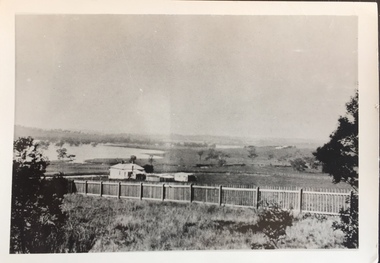
... , but is now East Kew, was frequently subjected to flooding. Apart from... East Kew, was frequently subjected to flooding. Apart from some ...The Yarra Valley in what was previously called North Kew, but is now East Kew, was frequently subjected to flooding. Apart from some development on higher ground, the City of Kew regularly introduced restrictions on development and the building of housing in the area because of flood levels. Panoramic photographic positive of North Kew where the Belford and Kilby Farms were located on the south side of the Yarra River. This photo is a copy of the original photo in the collection.floods -- yarra -- 1903, kew golf course, greenacres golf course -
![Construction of the electric tram line in Cotham Road [Kew]](/media/collectors/550653872162f11fb04854aa/items/66288f7f6214a76cee3ea3d8/item-media/66288fe96214a76cee3ead36/item-fit-380x285.jpg) Kew Historical Society Inc
Kew Historical Society IncPhotograph - Construction of the electric tram line in Cotham Road [Kew], E.J. Dower, 1913
... Annotation verso: "Preparing tram line Cotham Road Kew... Kew looking east for electric trams / 1913 / The metal ...One of a small album of six photographs of the construction of the Cotham Road tramline in Kew, taken by Edgar James Dower in the second decade of the twentieth century. The reverse of each photo contains notes, written over time by the photographer, which are contained in the 'Inscriptions' field. Born and raised in Olinda, Dower's family later moved to Surrey Hills. He worked as an adult as a clerk in the city office of the Metropolitan Gas Company, and in his role as a 'collector', he was able to photograph scenes including the construction of tram and train lines and associated buildings in Kew, Hawthorn, Camberwell and Surrey Hills. Later he established a real estate agency with his brother - the E.J. Dower Real Estate Agency, Dandenong Office. The album as a whole can be viewed separately as the parent file.The image is an historically significant record of the development of transport infrastructure which was used to connect Victorians in the first two decades of the twentieth century. This development resulted from increases in population and the consequent extension of Melbourne's suburbs. The photographs in the album, as well as Dower's single photos mounted on card, individually and collectively richly detail the labour of workers and the tools and machinery used to create and extend Melbourne's tram and train networks in the years preceding and during World War 1.The fourth of six annotated photos in an album of photographs of the construction of the St Kilda to Kew electric tram line, taken in Cotham Road, Kew, by the amateur photographer, Edgar James Dower, in 1913. The album contains images detailing the preparation for the laying of the tracks plus work laying the line. The photographer notes on a number of the photos that the metal tracks were collected from the Hawthorn railway siding. The album, together with other phots by E.J. Dower has been made available by the owners for the Kew Historical Society to digitise and publish online and in print.Annotation verso: "Preparing tram line Cotham Road Kew looking east for electric trams / 1913 / The metal was brought by horses and drays, from Hawthorn railway siding / 1913".keywords, theme -- connecting victorians by transport and communications, theme -- travelling by tram, photographers -- edgar james dower, cotham road -- kew (vic.) -
 Kew Historical Society Inc
Photograph, Burke Road Bridge, 1930s
... East Kew and Ivanhoe. The previous bridge, constructed in 1926... Bridge linking East Kew and Ivanhoe. The previous bridge ...Without bridges, Kew remained cut off from the City of Melbourne, only being accessible by Punt. Private and public bridges were constructed from the 1850s, beginning with the Hawthorn Bridge linking Bridge and Burwood Roads. A bridge across the Yarra at Burke Road was created as early as 1873. Since that first wooden bridge, a number of later bridges, typically on concrete pylons have been built, in 1926 and again during the 1970s.Sepia, faded photograph of the Burke Road Bridge linking East Kew and Ivanhoe. The previous bridge, constructed in 1926 was submerged beneath the flood waters in the 1934 mega-flood of the Yarra.burke road bridge (kew), bridges -- river yarra -
 Kew Historical Society Inc
Postcard, Yarra Falls, The Yarra at Studley Park, 1920-1950
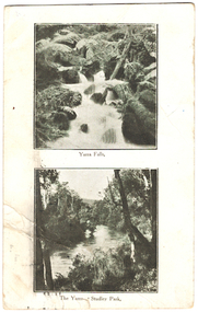
... "Mrs Clark, Harp Road, East Kew / Wishing Mother a very... postcards "Mrs Clark, Harp Road, East Kew / Wishing Mother a very ...The Yarra River was a major subject for the producers of postcards in Melbourne. This dual image postcard shows images of the Yarra in two locations. Studley Park in Kew was a major location for recreation activities by the people of Melbourne.Image of the Yarra at Sudley Park shows remnant vegetation preserved on the banks of the Yarra in this part of Kew.Monochrome postcard with two images of the Yarra River, the lower image showing the Yarra at Studley Park. The reverse has a handwritten birthday greeting from Eileen to her mother Mrs Clark. Original postage stamp has been removed and slight tearing in top right corner. Two ink stamps KEW HISTORICAL SOCIETY have been added."Mrs Clark, Harp Road, East Kew / Wishing Mother a very happy Birthday and many returns / from Eileen"yarra falls, dual image postcards, yarra river -- studley park -- melbourne (vic.), monochrome postcards -
 Melbourne Legacy
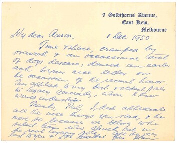
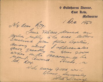
Letter, Legatee Savige to Legatee Aaron Beattie, 1950
... gothic font '9 Goldthorns Avenue, East Kew, Melbourne.... '9 Goldthorns Avenue, East Kew, Melbourne. Cream note dated 1 ...A letter from Legatee Savige to Legatee Aaron Beattie. It appears to be a reply to a letter congratulating him on his knighthood in 1950.A record of a note between Legatees.Cream note dated 1 December 1950 from Stan Savige to Aaron Beattie.Note card is printed with Stan Savige's address in blue gothic font '9 Goldthorns Avenue, East Kew, Melbourne.stan savige, aaron beattie -
 Melbourne Legacy
Letter, Legatee Savige to Legatee Roy, 1950
... gothic font '9 Goldthorns Avenue, East Kew, Melbourne.... in blue gothic font '9 Goldthorns Avenue, East Kew, Melbourne ...A note from Legatee Savige to Roy, presumably a Legatee. It appears to be a reply to a letter congratulating him on his knighthood in 1950. Part of the note says: "an earlier reply to the nice letters received from fellow legatees, among which I appreciated yours greatly in your good wishes on the occasion of the recent award. Thanks a lot, Roy. With every good wish, Yours sincerely, Stan Savige."A record of a note between Legatees.Cream note dated 1 December 1950 from Stan Savige to Roy - presumably a Legatee.Note card is printed with Stan Savige's address in blue gothic font '9 Goldthorns Avenue, East Kew, Melbourne.stan savige, knighthood -
 Kew Historical Society Inc
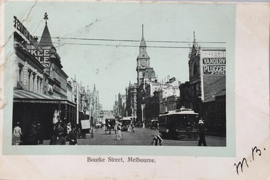
Postcard, Bourke Street, Melbourne, 1920-1920
... Mrs L. Clark, Ecclesbourne, Harp Road, East Kew / Wishing...) photographic postcards Mrs L. Clark, Ecclesbourne, Harp Road, East Kew ...The Kew Historical Society's postcard collection includes views of Kew, Melbourne and Greater Melbourne as well as those including overseas scenes sent or received from Europe or the Middle East. They date from the 1890s to the 2000s. These postcards may or may not include the name of the publisher or printer. A number of the cards were published as parts of popular series. A way of dating early postcards is to identify whether the reverse was divided by a central line which became the norm after 1902 in the United Kingdom. However, other postcards produced after this date do not always conform to this print layout.Monochrome postcard of Bourke Street, Melbourne, looking west from Swanston Street. The costumes of the women in the photograph would indicate the use of an earlier photograph dating from the 1885-1895.Mrs L. Clark, Ecclesbourne, Harp Road, East Kew / Wishing you many happy returns of the Day, M. Boylebourke street - melbourne, postcards -- melbourne (vic), photographic postcards -
 Kew Historical Society Inc
Plan - Subdivision Plan, Camberwell Mountain View Estate, 1923
... of these are of Kew, Kew East or Studley Park, although a smaller number... of these are of Kew, Kew East or Studley Park, although a smaller number ...The Kew Historical Society collection includes almost 100 subdivision plans pertaining to suburbs of the City of Melbourne. Most of these are of Kew, Kew East or Studley Park, although a smaller number are plans of Camberwell, Deepdene, Balwyn and Hawthorn. It is believed that the majority of the plans were gifted to the Society by persons connected with the real estate firm - J. R. Mathers and McMillan, 136 Cotham Road, Kew. The Plans in the collection are rarely in pristine form, being working plans on which the agent would write notes and record lots sold and the prices of these. The subdivision plans are historically significant examples of the growth of urban Melbourne from the beginning of the 20th Century up until the 1980s. A number of the plans are double-sided and often include a photograph on the reverse. A number of the latter are by noted photographers such as J.E. Barnes.The so-called Camberwell Mountain View Estate was a subdivision on ‘the corner [of] Burke Road, Eyre and Wills Streets, Deepdene’. The Estate was not the first attempt to subdivide this land holding. In 1884, 1888 and 1894 the Belmore Park subdivision proposed 18 allotments for this parcel of land. The final stages of the Belmore Park subdivision occurred during the Depression of the 1890s. Apart from perhaps one block facing Burke Road, which is unnumbered in the Mountain View Estate subdivision, the rest must have remained unsold. The later subdivision would redraw the original 18 allotments, creating 22 new lots. In the Locality Plan on the left side of the subdivision plan, Deepdene Station, which formed part of the Outer Circle Railway is represented, as is the location of Deepdene Primary School. A selling point was the proposed extension of the Burke Road tram beyond its terminus at Cotham Road. The extension did not eventuate.subdivision plans - camberwell, mountain view estate -
 Ballarat Heritage Services
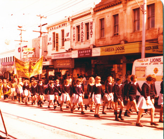
digital copy, K.P. Gervasoni, Kew Festival Parade St Anne's c1979, 1979
... School East Kew marching in High Street during the Kew Festival... photograph of students of St Anne's Primary School East Kew marching ...Copy of colour photograph of students of St Anne's Primary School East Kew marching in High Street during the Kew Festival. Lisa Gervasoni is in the centre left of shot, wearing a blazer and caught in mid march.kew, gervasoni, festival, parade, school, st anne's, primary, march, lisa, kew festival, lisa gervasoni -
 Kew Historical Society Inc
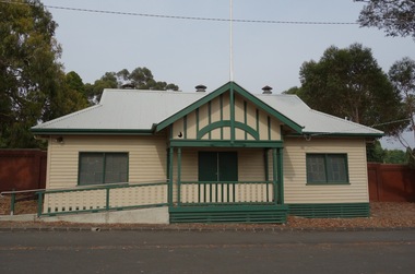
Photograph - Digital Photograph, Robert Baker, Harriers' Pavilion, Victoria Park (Kew), 2014, 2014
... of community groups, including the East Kew Women's Club.... of community groups, including the East Kew Women's Club. kew - sport ...While initially a pavilion at Victoria Park used by the Kew Harriers Club, the building was subsequently used by a range of community groups, including the East Kew Women's Club.Born digital image of the exterior of the renovated Harriers' Pavilion at Victoria Park (Kew)kew - sport pavilions, victoria park - kew (vic), kew harriers club -
 Kew Historical Society Inc
Photograph - Brick and Stucco Bungalow, J E Barnes, c.1920
... or East Kew. Unfortunately the handwritten information... locate din Kew or East Kew. Unfortunately the handwritten ...The Kew Historical Society's map collection includes a substantial number of real estate subdivision plans, mainly of Kew but also of surrounding suburbs in Melbourne. Most of the subdivision plans date from the 1920s and 1930s when the districts old homes and local farmland were being split up to accommodate residential growth in the postwar period. These early plans were assembled by a local firm, Jas R Mather & McMillan, which had an office in Cotham Road. Many of the plans, and sometimes photos, were annotated by the agents.Subdivision plans are historically important documents used as evidence for the growth of suburbs in Australia. They frequently provide information about when the land was sold as well as evidence relating to surveyors and real estate and financial agents. The numerous subdivision plans in the Kew Historical Society's collection represent working documents, ranging from the initial sketches made in planning a subdivision to printed plans on which auctioneers or agents listed the prices for which individual lots were sold. In a number of cases, the reverse of a subdivision plan in the collection includes a photograph of a house that was also for sale by the agent. These photographs provide significant heritage information relating house design and decoration, fencing and household gardens.The photograph may also be aesthetically significant depending o the importance of the photographic atelier.Real estate photograph for a local agent by the Kew photographer, Josiah Earl Barnes. The photo is of a weatherboard or brick rendered bungalow with a twisted wire fence. Given Barnes' status a a Kew photographer, the house is probably locate din Kew or East Kew. Unfortunately the handwritten information on the mount bordering the photo is damaged and cannot be read. The bungalow has a gabled, tiled roof with terra cotta finials at the front of both gables. The house has a central doorway, framed by a pseudo portico supported by four wooden columns. On each side of the doorway, at the front, there are paired sash windows, which, like the half-timbered gable, are picked out in a darker colour.Handwritten, mostly illegible description by selling agent on mount surround: " .... in Diningroom, Drawing Rooms, ... Photographers details printed on mount: "J. E. Barnes / Photo / Phone 1966 Haw KEW"houses - kew, bungalows - kew, real estate photographs, j.e. barnes -- photographer -
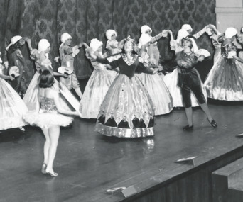 Melbourne Legacy
Photograph, Annual Demonstration
... Stamped "Leslie Thomspon / 8 Keystone Cres / East Kew WL... demonstration Stamped "Leslie Thomspon / 8 Keystone Cres / East Kew WL ...A photo of a junior legatees in elaborate ballgowns and old fashioned outfits, and wigs dancing on stage at the Annual Demonstration. Central characters appear to be a queen and a girl in a tutu as part of a dramatic dance routine. Legacy clubs ran classes for junior legatees for many years such as gymnastics, swimming or dancing classes. It was part of providing for the children of their deceased comrades. The skills they learned were show cased in an annual demonstration usually at the Melbourne Town Hall. It appears to be photo taken professionally of the Annual Demonstration. Year unknown.A record of a way Legacy provided classes for junior legatees and the skills learned were displayed in the Annual Demonstration.Black and white photo of junior legatees in ball gowns dancing on stage at Melbourne Town Hall.Stamped "Leslie Thomspon / 8 Keystone Cres / East Kew WL 3078" in purple ink. Handwritten 'Legacy P2' in blue pen.junior legatee, annual demonstration -
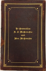 Kew Historical Society Inc
Document - Invitation, To Councillor A.J. McConchie and Mrs McConchie, 1928
... of the East Kew church, of which he was a trustee for 29 years. He... of the East Kew church, of which he was a trustee for 29 years. He ...Alan J. McConchie, a manufacturer’s agent, was elected to Kew Council in 1924, serving as a councillor for 21 years. He was elected Mayor of Kew in 1927-28, and again in 1945-46. During his second term as Mayor, he gained the support of Council for a pre-school plan which was the first of its kind in Victoria. The scheme established nursery schools and kindergartens as an extension of the existing baby health centres. Alan McConchie was active in Methodist Church work, and was one of the founders of the East Kew church, of which he was a trustee for 29 years. He was well known in the district as a cricketer and was a founder and past president of the East Kew Bowling Club. A Resident of Strathalbyn Street, he died in 1945 aged 60, while attending morning service at the East Kew Methodist Church. He is buried in the Burwood Cemetery. Handmade illuminated invitation to a notable Kew Mayor and MayoressAn illuminated invitation sent to the Mayor and Mayoress of Kew, Cr. and Mrs. McConchie, by a Citizens Committee to a Ball in the Kew Recreation Hall on 26 July 1928. The double page invitation is encased in an embossed maroon leather cover. The invitation was donated to the Society by a descendant of the McConchies in 2014.Inscription Cover: "To Councillor A.J. McConchie and Mrs McConchie". Inside cover in watercolour: "The Chairman Councillor George Ramsay and Members of the Citizens Committee desire the honor of the Company of HIS WORSHIP THE MAYOR OF KEW AND MRS. McCONCHIE at a BALL to be held in the Kew Recreation Hall Tuesday 26th July 1928 at 8 P.M. Tendered to them as a mark of recognition of the services rendered to the City during their Mayoral Year 1927".cr. a. j. mcconchie, mayor of kew (1927-28, 1945-46) -
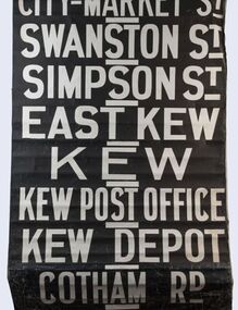 Kew Historical Society Inc
Functional object - Destination Roll, Melbourne & Metropolitan Tramways Board, 1960s
... East Kew, Kew, Kew Post Office, Kew Depot, and Cotham Road.... / Swanston St / Simpson St / East Kew / Kew / Kew Post Office / Kew... / East Kew / Kew / Kew Post Office / Kew Depot / Cotham Rd / Malv ...In an era predating the computerisation of equipment on public transport, where trams in Melbourne were driven by drivers and conductors sold fares, destinations were shown at the front and rear of the tram within a glazed box. A driver adjusted the roll to select each new trip destination. Given the length of rolls, in this case approximately nine metres, this could be a time consuming process. In addition to the named destination roll, each tram included a separate roll listing the route numbers.The roll was purchased at a Leski Auction in Armadale as part of a large group of tramways memorabilia including tram 'rolls' from New South Wales, Victoria, South Australia and Tasmania. The auction house described the collection as "The collection of destination blinds or rolls that forms the core of the Railways Trams & Buses Section (Lots 655 – 732) is the best we have ever offered and represents a life-time of collecting by an Adelaide enthusiast, now deceased." Melbourne & Metropolitan Tramways Board Tramways Destination Roll. Black and white paint on linen roll. Forty-eight named destinations including four depots - Camberwell, Hanna Street, Hawthorn, Kew. Multiple destinations in what is now the City of Boroondara (Kew, Hawthorn and Camberwell); including East Kew, Kew, Kew Post Office, Kew Depot, and Cotham Road.Named destinations beginning to end: “Olympic Park / Special / Football / Racecourse / Richmond / Burnley / Riversdale / Wattle Park - Warragul Rd / Wattle Park - Elgar Rd / City / Burwood / Hartwell / Bowen St / Camberwell Depot / Camberwell Jucn / Leura Grove / Gardener / Glenferrie Rd / Chapel St / St Kilda Rd / Camberwell / City / Lonsdale St / University / City via William St / Domain Rd / Hanna St Depot / South Melb & St Kilda Beach / Prahran / North Richmond / Windsor / Hawthorn Depot / Hawthorn / Spencer St / Toorak Rd / Swan & Church St Cnr / North Balwyn / City Flinders & Spencer Sts Corner / City - Market St / Swanston St / Simpson St / East Kew / Kew / Kew Post Office / Kew Depot / Cotham Rd / Malv Tn Hall"melbourne & metropolitan tramways board