Showing 10633 items
matching lander
-
 Whitehorse Historical Society Inc.
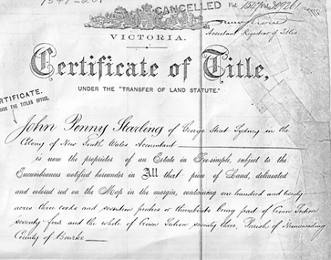
Land Title, Certificate of Title, 4/04/1884
Certificate of Title dated 4 April 1884 in the name of John Penny Starling. The land is between Whitehorse Road and 'Clarkes Road'. The land was leased to Edward Alexander and passed to Elizabeth Jane Starling in 1886.starling, john penny, alexander, edward, parish of nunawading, elizabeth jane, land sales, john penney -
 Phillip Island and District Historical Society Inc.
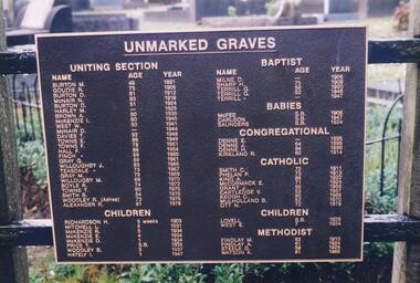
Photograph Album, Kodak, Phillip Island Cemetery, c 1990
The Album was compiled by Nancy McHaffie late 1990's, with the assistance of Edith Jeffery's, with her book "Garden of Memories" and extensive knowledge of Phillip Island. The Cemetery lies back from the road and is surrounded by Manna Gums, rare Peppermint Gums, Blackwoods and other native trees. In all 25 acres of land were set aside as Crown Land in the land settlement of 1868. There are 6.2 acres of wetlands near the cemetery entrance.2 Photographs: 466-08 Notice of the Unmarked Graves. Although the land for the cemetery was granted in 1870, a survey was not made until 1903 hence the existence of unmarked graves. 466-09 A disastrous fire swept through the cemetery in 1943, destroying many structures around the graves - hence the rule "no wooden structures". the Hitching Posts were used for tying up hrses during a funeral service. They were erected in 1912 and now only two remain.phillip island cemetery, nancy mchaffie, edith jeffrey -
 Kiewa Valley Historical Society
Photograph Farm Land, Mount Beauty Acreage before Golf Course, Circa 1950
This photograph is a "snap shot" in time circa 1950s detailing the rural environment before the effects of the Kiewa Valley Hydro Scheme altered the basic rural setting of the valley. The golfing fairway was being mapped out on previous grazing land, before the laying of a golf course, for use by the construction workers and auxiliary administration employees of the Victorian State Electricity Commission. This photograph details a dramatic period in time which saw an enormous change to the exclusively rural area of the Kiewa Valley region in the mid 1900s. This change presented both physical and mental challenges to the existing quiet rural inhabitants of the valley. The State of Victoria had to make adjustments to the changing demands imposed by population and industrial expansions. The development of cleaner energy supplies to a growing population has its downside ,which ever way the intrusion into the "natural" landscape is made.Black and white photograph detailing surveyor posts for construction of golf course. Land used, before establishment of the Mount Beauty Village, as farming/grazing cattle and viewed towards Mount Bogong and its Alpine ranges. The photo is on 200gms paper and not on photographic paper.nilmount beauty in the 1940s - 1950s, grazing in the kiewa valley, sec victoria -
 Bendigo Historical Society Inc.
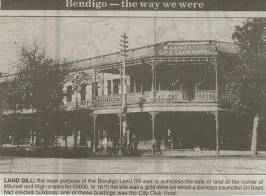
Newspaper - JENNY FOLEY COLLECTION: LAND BILL
Bendigo Advertiser ''The way we were'' from 2000. Land Bill - The main purpose of the Bendigo Land Bill was to authorise the sale of land at the corner of Mitchell and High streets for 9000 Pounds. In 1870 the site was a gold mine on which a Bendigo councillor, Dr Boyd, had erected buildings, one of these buildings was the City Club Hotel. The clip is in a folder.newspaper, bendigo advertiser, the way we were -
 Whitehorse Historical Society Inc.
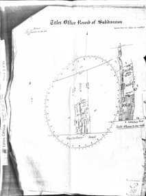
Document - Land Title, Titles Office Record of Subdivision, 25/11/1885
Photocopies of record of subdivision of David Boyle's land in Canterbury Road, Forest Hill covering the period from November 1885 to February 1898 including a scale drawing of the land and the creation of an easement for Mount Pleasant Road.boyle, david, walter, william james, joseph nash, alexander, janet kennedy, furborough, henry, canterbury road, forest hill, mount pleasant road, land subdivision -
 Whitehorse Historical Society Inc.
Legal record - Land Title, Crown grant, 1858
Commercial Bank of Australia record of Crown Grants of land to Nelson Polak and Louis Laurence Smith in 1858.Commercial Bank of Australia record of Crown Grants of land to Nelson Polak and Louis Laurence Smith in 1858. The land is between Canterbury Road, Heatherdale Road, 'Scoresby Road' (now Boronia Road) and the Dandenong Creek.Commercial Bank of Australia record of Crown Grants of land to Nelson Polak and Louis Laurence Smith in 1858. polak, nelson, smith, l l dr, canterbury road, vermont, boronia road, dandenong creek, heatherdale road, land sales -
 Whitehorse Historical Society Inc.
Article, Carving up the Eastern Suburbs
Newspaper article about Tommy Bent and Sir Benjamin Benjamin and their land buys in the Eastern SuburbsNewspaper article about Tommy Bent and Sir Benjamin Benjamin and their land buys in the Eastern Suburbs, and the 'Queens Park Tenner' issued as a deposit for a land sale, cnr Station Street and Canterbury Roads (copy shown)Newspaper article about Tommy Bent and Sir Benjamin Benjamin and their land buys in the Eastern Suburbsland subdivision, station street, box hill, canterbury road, bent, thomas, benjamin, benjamin (sir), queens park estate, queens park tenner, freehold investment and banking company of australia ltd -
 Southern Sherbrooke Historical Society Inc.
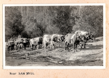
Photograph, Near Saw Mill
Ten or more cattle pulling logs to a sawmill (possibly McLaren's sawmill in Belgrave). The land around the track is cleared and it is heavily treed in the background. There is dead timber lying around and the land looks dry. c.1920. -
 Kew Historical Society Inc
Photograph - Flooding of the Yarra Valley at Kew East, 1974
Flooding of the Yarra Valley, including that section of the Yarra bordering Kew and Kew East in the north and west of the municipality, was a regular occurrence. Extreme flood events of the Yarra River are recorded to have occurred in 1891, 1901, 1916, 1923 and 1934. The Municipality of Kew's response to these floods was to enact planning decisions restricting residential development in flood prone areas following the floods of 1916, 1921 and 1934. While floods continued after the development of the Upper Yarra Reservoir (construction 1948-57), the regularity and extent of these inundations diminished. During the nineteenth century, the land abutting the south side of the Yarra in Kew was devoted to dairy farming. In the twentieth century, before and after the construction of the Eastern Freeway, much of this low-lying area was used as golf courses and public parks.Late example of the capacity of the Yarra Valley at Kew to flood, even though drainage works and the Upper Yarra Reservoir had reduced their regularity.Original black and white print photograph of the low-lying land at East Kew under floodwater on 16 May 1974. The vantage point of the photographer is at Willsmere Road. The road itself is underwater.Annotation verso: "Willsmere Rd / Same as No.7 / 16 May 1974 11.15am"floods, yarra river, willsmere road -
Whitehorse Historical Society Inc.
Document, 'Willowbank', 1985
Notes by Jean Uhl on interview, 1985, about 'Willowbank'Notes by Jean Uhl on interview, 1985, about 'Willowbank', used to be called 'Willowbridge' (named 'Willowbridge' by Mrs B. Rawson). Home was built 1880, land originally subdivided by Gerard Letts, German family thought to be original builders. Situated at 3 Moore Road, Vermont. 1978 purchased by R.B. Evans,Notes by Jean Uhl on interview, 1985, about 'Willowbank'willowbank', uhl, jean, letts, gerard, rawson, b. (mrs), evans, r.b. (mr), moore street, vermont, no. 3 -
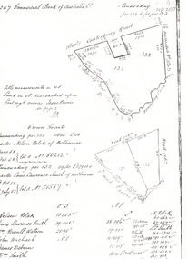
 Phillip Island and District Historical Society Inc.
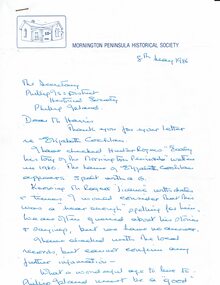
Letter, Eliza Cochlan, information on spelling of her name, 1986
The spelling of Eliza's surname varies between Coghlan and Cochlan in various sources.The letter does not provide proof of either. List of applicants for land at Schnapper Point [Mornington, including Phillip Island], early settlers and their date of arrival. An extract from "Early History of Mornington" showing residents of Schnapper Point in 1858.HistoricalHand written letter from the secretary of the Mornington Peninsula Historical Society re the spelling of Eliza Cochlan's name . Dated 8/5/1986 Also 3 typed pages containing a list of applicants for Phillip Island land grants and extract from The Early history of Mornington.Letter addressed to Mr Harris, secretary PIDHSeliza cochlan, land grant, early phillip island settlers, land ballot -
 Charlton Golden Grains Museum Inc
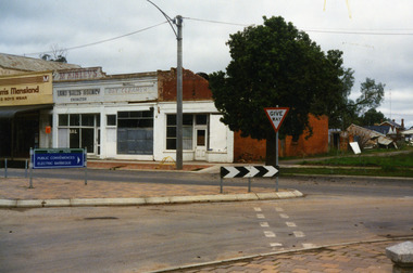
Photograph, West end Charlton High St c. 1987
Shops at the west end and on the south side of High St. Eddie Harris Mensland, and three small shops; Charles McKinley's Land Sales Agency, Hillier's Dr Cleaners and Manchester Unity. The three small shops were damaged by fire and demolished in the 1990s. Series of photos taken for use by the Charlton Shire.Colour photo of shops at the west end and on the south side of High St.Eddie Harris Mensland, Mickinley's Land Sales Agency, Hillier's Dr Cleaners and Manchester Unity. Sign on median strip pointing to Rotary Park, Public Conveniences, Electric Barbeque. Also a Give Way sign.eddie harris mensland, charles mckinley, hilliers -
 Bendigo Historical Society Inc.
Photograph - Kangaroo Flat Gold Mine Collection: photos of Woodvale site, Daly property, pre dam construction, 1986
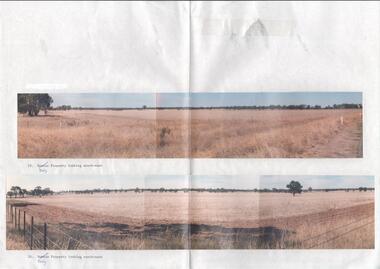
Photographs taken at the time of the purchase by Western Mining Corporation of the property owned by G.P. Daly of Raywood Road, Woodvale, in 1986. The intent of the purchase was to provide land for the Woodvale ponds. Land size was 16 acres, known as Allotment 13, Section 3, Parish of Nerring. Paper with two colour photographs attached, each of three photos joined to show landscape view, of the property purchased from G.P Daly by Western Mining Corporation. Photographs show rural land, grassy paddocks with tree line in background. Barb wire fence visible in foreground of bottom photo. Top photograph is titled 23. Daly property looking south-east. Bottom photograph is titled 24. Daly property looking north east. woodvale, g.p. daly, western mining corporation, purchase -
 City of Greater Bendigo - Civic Collection
Administrative record - Land Sales, A. J. Mullet Government Printer et al, 1927
This type of album was made by agents auctioning and selling land.Large portfolio style album with dark green / black cloth cover bound with three large metal pins. Forty eight pages with twenty seven Department of Lands and Survey maps and newspaper clippings about land sales and auction details pasted in. Index page. Maps have handwritten notes and markings throughout in pencil and pen. Covers the County's of Gunbower and Tatchera. Includes a receipt slip with hand written notes on reverse on William Wallace & Co letterhead. city of bendigo commerce -
 Kew Historical Society Inc
Plan, Studley Park Estate, 1910
Prue Sanderson, in her groundbreaking ‘City of Kew Urban Conservation Study : Volume 2 - Development History’ (1988), summarised the periods of urban development and subdivisions of land in Kew. The periods that she identified included 1845-1880, 1880-1893, 1893-1921, 1921-1933, 1933-1943, and Post-War Development. These periods were selected as they represented periods of rapid growth or decline in urban development. An obvious starting point for Sanderson’s groupings involved population growth and the associated economic cycles. These cycles also highlighted urban expansion onto land that was predominantly rural, although in other cases it represented the decline and breakup of large estates. A number of the plans in the Kew Historical Society’s collection can also be found in other collections, such as those of the State Library of Victoria and the Boroondara Library Service. A number are however unique to the collection.The Kew Historical Society collection includes almost 100 subdivision plans pertaining to suburbs of the City of Melbourne. Most of these are of Kew, Kew East or Studley Park, although a smaller number are plans of Camberwell, Deepdene, Balwyn and Hawthorn. It is believed that the majority of the plans were gifted to the Society by persons connected with the real estate firm - J. R. Mathers and McMillan, 136 Cotham Road, Kew. The Plans in the collection are rarely in pristine form, being working plans on which the agent would write notes and record lots sold and the prices of these. The subdivision plans are historically significant examples of the growth of urban Melbourne from the beginning of the 20th Century up until the 1980s. A number of the plans are double-sided and often include a photograph on the reverse. A number of the latter are by noted photographers such as J.E. Barnes.Coloured lithograph of a subdivision plan of the Studley Park Estate, bordered by Yarra, Willsmere Road and the Outer Circle Railway line. The estate was listed in 1910 and was the subject of a planning dispute between the developer and the Town of Kew in relation to flood levels and the suitability of the land for housing. In many cases the names of streets were subsequently changed. The layout was also affected by the creation of the Eastern Freeway. A newspaper report of the day described the subdivision as a: "GOLDEN OPPORTUNITY. We are pleased to submit for PRIVATE SALE that magnificent ESTATE, situated only 4 1/2 miles from the Melbourne General Post Office, STUDLEY PARK ESTATE. KF/NV. Doubtless the CHEAPEST LAND EVER OFFERED having extensive frontages to the prettiest spot on the River Yarra and the National Park, commanding lovely river and landscape views, and acknowledged to be the finest land available so close to the city. The PRICES ARE EXTREMELY MODERATE; The TERMS ARE SIMPLY MARVELLOUS. NO DEPOSIT. NO DEPOSIT. NO DEPOSIT. Allotments and prices to suit everyone."subdivision plans - kew, studley park estate -
 Falls Creek Historical Society
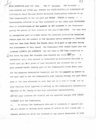
Document - Report - Proposed Falls Creek Tourist Hotel Project, 27.3.1963
Bob (Herman) Hymans (a former member of the Royal Netherlands Navy) was born in Bloemendaal, Holland on 30th September 1922. During World War II he fought against the Japanese in the Dutch East Indies (now Indonesia) and was imprisoned in Changi and on the Burma Railway. After gaining qualifications as a Ski Instructor, Bob arrived in Falls Creek in July 1950. Working as an Instructor and Supervisor at Bogong Lodge, Bob decided his future was in accommodation. He was successful in negotiating an indenture for land from the State Electricity Commission (SEC). It took Bob two years to build his Grand Coeur Chalet but, tragically, it was burned down in August 1961. Bob also built the first Chairlift in Australia. This was a single chairlift and the structure was built from wooden electricity poles. He was constantly full of new ideas and proposals for the village. Bob Hymans die on 7th July 2007. This Collection of documents and letters tells the story of Bob's endeavours to develop Falls Creek into the ski village it is today.This item is significant because it documents proposals put forward by Bob Hymans to develop facilities in the Falls Creek Tourist Area.A typed report of aspects of Bob Hymans' application for a lease of land to establish a new hotel at Falls Creek. The document has some works underlined and handwritten notes added.falls creek tourist area management committee, hymans' hotel plans, falls creek development -
 Falls Creek Historical Society
Document - Indenture Between State Electricity Commission & Herman Hymans, 28.11.1956
Bob Hymans Collection Bob (Herman) Hymans (a former member of the Royal Netherlands Navy was born in Bloemendaal, Holland on 30th September 1922. During World War II he fought against the Japanese in the Dutch East Indies (now Indonesia) and was imprisoned in Changi and on the Burma Railway. After gaining qualifications as a Ski Instructor, Bob arrived in Falls Creek in May 1950. Working as an Instructor and Supervisor at Bogong Lodge, Bob decided his future was in accommodation. He was successful in negotiating an indenture for land from the State Electricity Commission (SEC). It took Bob two years to build his Grande Coeur Chalet but, tragically, it was burned down in August 1961. Bob also built the first Chairlift in Australia. This was a single chairlift and the structure was built from wooden electricity poles. He was constantly full of new ideas and proposals for the village. Bob Hymans died on 7th July 2007. This Collection of documents and letters tells the story of Bob’s endeavours to develop Falls Creek into the ski village it is today.This document is significant because it documents the story of an important pioneer of Falls Creek.A 5 page indenture or contract typed on paper. This document sets out the terms and conditions set down for the lease of land in Falls Creek at the cost of £1 per week.legal contract, bob hymans -
 Surrey Hills Historical Society Collection
Book, Medlow and the Bismark Estate by Prof. Miles Lewis, 1990
The Medlow Estate is a remarkable testimony to the unfulfilled expectations of the land boom of the 1880s to early 1890s. The areas of the former lot 14 or the lines of Varzin Avenue and Friedrichsruh Street where they pass through the present grounds will be conserved as may seem appropriate to exhibit the development of the garden in the Cairncross and Bull periods.The Medlow Estate is a remarkable testimony to the unfulfilled expectations of the land boom of the 1880s to early 1890s. The areas of the former lot 14 or the lines of Varzin Avenue and Friedrichsruh Street where they pass through the present grounds will be conserved as may seem appropriate to exhibit the development of the garden in the Cairncross and Bull periods.bismark estate, rosalie estate, conservation of natural resources, (mr) rex swanson, landform australia, cairncross family, medlow, varzin avenue, warrigal road, surrey hills, friedrichsruh street, (mr) (dr) r j bull, (miss) mary jane cairncross, g n taylor -
 City of Moorabbin Historical Society (Operating the Box Cottage Museum)
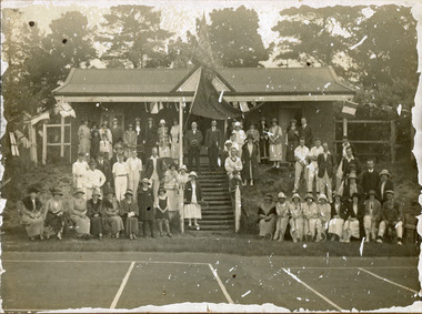
Photograph, black & white Cheltenham Tennis Club 1920, and 2 Documents, 1920
Cheltenham Tennis Club was established 1883 when Shire of Moorabbin released land in Cheltenham Park for recreational use. 1924 The Shire of Moorabbin gave permission for the development of extra Courts.Cheltenham Tennis Club 1883 was one of the first Tennis Clubs established in Melbourne.A black and white photograph of men and women seated and standing in and around the Cheltenham Tennis Clubhouse in Cheltenham Park, Cheltenham in 1920. Letter Handwritten 1883 Shire of Moorabbin, South Brighton , release of land in Cheltenham Park for the development of Tennis Courts. Letter Typed 1924 Shire of Moorabbin, permission for extra Courts, signed by the shire secretary, Alexander Chalmers Smith.PHOTO ; written on back : Cheltenham Tennis Club 1920 / Cheltenham Park Letter ; signed John Keys Shire of Moorabbin South Brighton Logo 1871 Letter ; Shire of Moorabbin Logo 1924charman road, cheltenham, 1920, tennis club. charman stephen, gettens mary, spring grove, charman road, balcombe road, nepean road, dairy farmers, market agrdeners, poultry farmers, methodist church, keys john, shire of moorabbin, colsamix, cheltenham park melbourne, sabbath victorian law article 26, cheltenham golf club -
 Phillip Island and District Historical Society Inc.
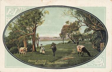
Photograph - Post Card, 1900's
Donated by Jean ParleColoured Postcard of cowes grazing with figures of a woman and child. Sea and land in background."Phillip Island - Milking Time, Newhaven." "F & J"cowes grazing at newhaven, pasture land, phillip island, jean parle -
 Halls Gap & Grampians Historical Society
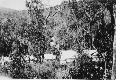
Photograph - Sepia, C 1920s
Photo is said to be that of roadmakers camp for workers on the construction of the Mt Victory RoadPhoto shows a number of tents in bush land, said to be road makers campRoad makers camp Mt Victory Rd during the dat 1920sstructures, tents, access routes, road building -
Eltham District Historical Society Inc
Folder, Benjamin Baxter, 1840
Folder of information on Captain Benjamin Baxter, land purchaser, Lower Plenty, 1840benjamin baxter -
Eltham District Historical Society Inc
Folder, Stuart Alexander Donaldson, 1840
Folder of information on Sir Stuart Alexander Donaldson, land purchaser, Montmorency, 1840stuart alexander donaldson -
Ringwood and District Historical Society
Book, Borough of Ringwood Land Purchase Fund Cash Book and Ledger
Bound book "Borough of Ringwood Land Purchase Fund Cash Book and Ledger" -
Glenelg Shire Council Cultural Collection
Photograph - Photograph - Lee B'water / Tanker Berth, n.d
Port of Portland Authority Archivesport of portland archives -
 Bendigo Historical Society Inc.
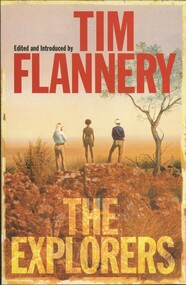
Book - TIM FLANNERY THE EXPLORERS, 1998
Tim Flannery, The Explorers. 385 pages. Major explorers of Australia, sea and land.Tim Flanneryaustralia, history, explorers, exploration of australia, explorers, tim flannery -
 National Vietnam Veterans Museum (NVVM)
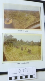
Photograph
Two coloured Photograph in a black frame with titles: "About to land' & "Our passengers".helicopters, photograph -
Port Melbourne Historical & Preservation Society
Letter - Lands & Survey Office re land for football ground, 19 Apr 1880
Letter from Lands & Survey Office regarding land for football ground, 1880sport - australian rules football, sport - recreational grounds, peter gallienne grut, port melbourne football club, pmfc -
Port Melbourne Historical & Preservation Society
Plan - Football Ground, Department of Survey & Lands, 13 May 1880
Plan for Football Ground on land being granted by Department of Survey & Lands, 1880sport - australian rules football, sport - recreational grounds, j kitchen & sons pty ltd, port melbourne football club, pmfc -
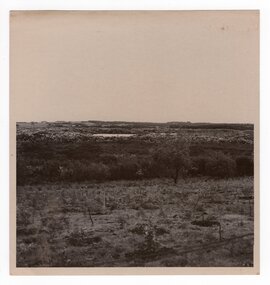 Churchill Island Heritage Farm
Photograph of cleared land, Unknown
Churchill Island Heritage Farm has a large photograph collection dating from the mid-nineteenth century to the last decade. This series of photographs show events and people from the Churchill Island precinct and the enormous amount of collaboration and work that went into the development of the heritage area and making it accessible and interactive for visitors of all ages. Black and white photograph showing cleared land and young trees. White border.Catalogue number in pencil on reverse. "SG667/10" on reverse in pencilchurchill island, estuary, aerial photograph