Showing 114813 items
matching orbost-brodribb-road
-
 Marysville & District Historical Society
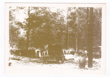
Postcard (item) - Black and white postcard, Marysville & District Historical Society Inc, Bullock Teams at the Dump, Woods Point Road, 1993
A black and white photograph of bullock teams at the Log Dump at on the Wood's Point Road.A black and white photograph of bullock teams at the Dump at on the Wood's Point Road. The Marysville-Woods Point Road was originally part of the Yarra Track, constructed in the early 1860s to provide access between Healesville and the Woods Point Goldfields. Despite the steep terrain and engineering difficulties, the Yarra Track soon became a busy route used by pack horses, horse-drawn drays, and wagons. Today this sealed mountain road is a popular scenic drive between Marysville and Warburton. This postcard was produced by the Marysville Historical Society as a souvenir of Marysville.YESTERYEAR POSTCARDS AFFIX/ STAMP/ HERE BULLOCK TEAMS AT THE DUMP,/ WOODS POINT ROAD. C Marysville Historical Society, 1993marysville, bullock teams, woods point road, victoria, marysville historical society, postcard, souvenir, yesteryear postcards, marysville-wood's point road, yarra track, healesville, mining, timber mills, warburton -
 Orbost & District Historical Society
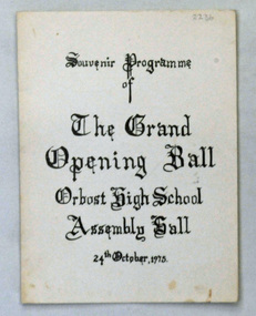
program, Snowy River Mail as "Mail" Print, 1975
This item was produced as a souvenir for the opening of the Orbost High School Assembly hall. The ball was held on October 24, 1975. The school was established in 1912.Orbost High School / Orbost Secondary College has played a significant part in the education of senior students in the Orbost district . It is the sole senior educational institution. This item is representative of its history. Balls werefor many years a common community event in the Orbost district.A rectangular cardboard program for the "Grand Opening Ball Orbost High School Assembly Hall". It is a single card folded in half with black print on a white background.orbost-high-school dance-ball entertainment recreation -
 City of Ballarat
Artwork, other - Public Artwork, Travis Price, Main Road Mural by Travis Price, May 2018
Whilst my main focus for the artwork design was on the Hotels on Main Road, I felt there was an opportunity to tell a broader story of Main Rd and combine/include some interesting pieces of information from many stages of the history of Main Road. Considering that at one point in time there would have been at more than six hotels in this very short section of street….there’s no doubt Main Rd was an epicentre of communication and festivities for the Goldfields of Ballarat. “No matter what luck he had, every miner needed supplies, food and something to entertain him when he was not searching for gold.” Described as being an overcrowded jumble of muddy streets loosely arranged around mining camps...and loud, muddy, colourful and sometimes illicit. I wanted the artwork composition to consist of overlapping images and text to reflect this sense of hustle and bustle. Main Road Mural tells the broader story of the history of Main Road in Ballarat. In 2018, the City of Ballarat commissioned local Ballarat artist Travis Price to create an artwork to align with the Main Road Revitalisation Project and deliver a key component of the storytelling (heritage interpretation) project that spans the length of the shopping precinct. The artwork is featured on a prominent site in the shopping precinct of main road and tells the story of Main Road through depicting key timeline events. Main Road, as its name suggests, was one of the main entries to the mining areas of East Ballarat. It had several names: Main Street before 1858, Plank Road between 1858 and 1868 and Main Road from 1868 onwards. The centre of mining life, it was crowded, prosperous, raucous and dirty. Painted mural on shop wall in Main Road, BallaratBallaarat, Gold Fever, The Royal Standard Hotel, Flood, Boxing Saloon, Plank Road, Kulin Nation, 3350, Election, East, Grog House, The Scandinavian Hotel. Images; Chinese lantern, Pick & Shovel, Miners Licence burning.main road history, ballarat hotels, gold fever, wadawurrung, kulin nation -
 Orbost & District Historical Society
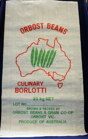
seed bag, mid 20th century
Orbost Beans & Grains Co-Op was an extension of Snowy River Sweet Corn Co-Op which also sold fresh produce such as corn, squash, zucchini and cucumbers. This bag is unused and would have been packed with borlotti beans.Snowy River Seeds started life as a farmers' co-operative (Snowy River Co-op) in 1967. This item is significant because it was specially made for the seed bean industry which was a major industry in the Orbost district for over a century. A white woven synthetic bag used for packing borlotti beans. Inside a red outline of Australia are seven green beans. Victoria is outlined and Orbost is indicated with a red d t. Print is red and green. On front : Grown & Packed By Orbost Beans & Grain Co-Op 25 kg Orbost Victoria Produce of Australia seed-bag snowy-river-co-op agriculture farming orbost-beans -
 Orbost & District Historical Society
black and white photograph, 1915 ?
This is a photograph of a group of students of the Orbost Higher Elementary School dressed in costume performing "The Poppy Song:" on a stage. In the photograph are: Dolly Broome; Mary Reynolds; Lily Perry; Hilda Guy; Rene Parker; Madge Grose; Audrey Cameron; Annie Gibbs, Zenie Irvine and Violet Gibbs. This is probably the song connected with a poem called “In Flanders Fields” written by Major John McCrae, a Canadian surgeon attached to the 1st Field Artillery Brigade and stationed at Ypres salient, Belgium, in the spring of 1915. During 1910-11 the first approaches were made to the Department for the establishment of a HES in Orbost and this became a reality in 1912. Orbost HES supplied post-primary education in the district until a high school was built in 1948. Orbost High School / Orbost Secondary College has played a significant part in the education of senior students in the Orbost district . It is the sole senior educational institution. This item is representative of its history.A black / white photograph with a label attached. It is of a group of students in costume on a stage. Each figure has been numbered 1 - 13.on label attached to bottom - "POPPY SONG ORBOST HES ?1915" with a list of names.education-orbost orbost-higher-elementary-school poppy-song -
 Orbost & District Historical Society
hesssian, mid 19th century
George Temple, born in Yorkshire on 26/2/1832 was one of the earliest Orbost storekeepers. Temple's Store was on the corner of Ruskin and Nicholson Streets opposite the post office. He packed stores to the Bendoc area goldfields. The store building eventually became part of Herbert's store when he died in 1917.George Temple was one of Orbost's earliest storekeepers.A large piece of hessian - probably an opened bag which was used for sending goods. The material is pinned around cardboard. It has black lettering stencilled on it."1850 G. Temple Orbost via Cunninghame carpenter"temple-george -
 Orbost & District Historical Society
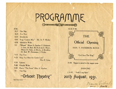
program, 1931
The official opening of the Obost Theatre was held on 20th August, 1931, opened by Hon. T. Paterson M.H.R. Thomas Paterson was Minister for Markets and Migration from June 1926 to January 1928. He was elected as the Country Party Member for Gippsland in 1922 and held the seat until he retired in 1943. In January 1928 his portfolio was changed to Minister for Markets and in December of that year it was again changed to Minister for Markets and Transport. Nance Gilbert was the sister of Mary Gilbert, Orbost teacher and historian. Nance Jenning was a professional golfer, daughter of Jonathon Gilbert and Annie Cameron.This item is reflective of local community events in the first half of the 20th century.A white, rectangular paper program with blak ink. It is for the official opening of the "Orbost Theatre".On front - "Nance Gilbert - Aged 6 years"orbost-theatre-program paterson-thomas -
 City of Kingston
Pamphlet - Colour, Farrow Falcon Press, Printers, Ozone Estate, Bluff Road, Hampton, c.1940
Sales plan for land in the suburb of Hampton (Highett), bounded by Bluff Road, Wickham Road, Peterson Street and June Street. Includes Morley Street, Follett Avenue, and Parrett StreetThe developing urban area of Highett within the City of Kingston. This land sale pamphlet illustrates the subdivision of land within the municipality and the changing demographic of the district as new houses are constructed close to infrastructure.Colour pamphlet advertising for private sale the Ozone Estate, Bluff Road Hampton. Incorporates a map of the estate bordered by Bluff Road, Wickham Road, June Street and Peterson Street including Morley Street, Follett Avenue and Parrett Street.Handwritten in grey pencil on reverse: Ozone Printed in purple ink on front top right-hand corner: Vendors are - Leslie Harcourt MacGowan, Esq / Neerim Road, Caulfield / & / Arthur Alfred Parrett, Esq / 311 Flinders Lane / Melbourneland sales, estate, hampton, highett -
 Orbost & District Historical Society
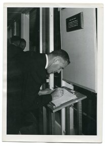
black and white photograph, 1962
This is a photograph of Bruce Evans, Member of the Victorian Legislative Assembly, signing the visitors' book at the Orbost High School Golden Jubilee in 1962. In 2012, Orbost Secondary College and the wider community celebrated 100 years of secondary education in Orbost. With earlier levels of schooling available at the Orbost State School or nearby schools of Newmerella and Jarrahmond School, it was not until April 1912, and after much campaigning from parents and other notable community members, that the Orbost Higher Elementary School was opened. Mr Richard Trembath was appointed the new Head teacher of Orbost Higher Elementary School and was assisted by Miss Olga Hirst. The senior class consisted of 26 pupils, and the junior class, 16 pupils. A limited curriculum was available which included lessons in Latin, Arithmetic, Algebra, Geometry, Geography, History, Drawing and advanced English. (inf0. from O.S.C. website)Orbost High School / Orbost Secondary College has played a significant part in the education of senior students in the Orbost district . It is the sole senior educational institution. A black / white photograph of a man in a suit signing a book.on back - hand-written -" Orbost H. S. Golden Jubilee 1962. Bruce Evans M.L.A. signing Visitors' Book>" -
 Mt Dandenong & District Historical Society Inc.
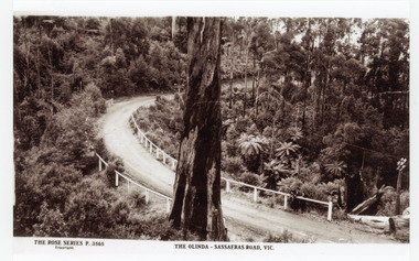
Photograph, The Olinda-Sassafras Road, Vic
Rose Series post card # P. 3565 showing the Sassafras - Olinda Road taken outside Rostrevor Guest House. Photograph taken pre 1920 prior to the pine plantation planted by Melbourne High School.Black and white copy of Rose Series post card P. 3565 showing a section of the Olinda - Sassafras Road with a large tree in the foreground.On Front: THE ROSE SERIES P. 3565 THE OLINDA - SASSAFRAS ROAD. VIC.sassafras-olinda road, sassafras, olinda, rostrevor, post card, the rose series, rose series -
 Orbost & District Historical Society
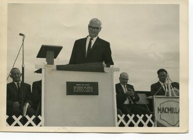
black and white photograph, 13 March 1962
This photograph shows Mr Alex McDonald, the head of the Education Department, opening the new extensions at the 1962 Golden Jubilee of the Orbost High School.Orbost High School / Orbost Secondary College has played a significant part in the education of senior students in the Orbost district . It is the sole senior educational institution. This item is representative of its historyA black / white photograph of a man standing behind a lectern on a stage delivering a speech. There are other seated behind him.on back - " Mr Alex McDonald, head of Education Depet. Orbost H.S. Jubilee, 1962" -
 Ringwood and District Historical Society
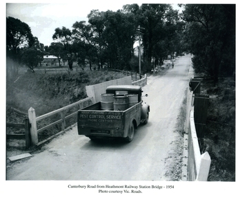
Photographs / Album Pages, Canterbury Road from Heathmont Railway Station Bridge 1954, 1954
Houghton & Byrne Pest Service Truck on Canterbury Road crossing Heathmont Railway Station Bridge 1954. Photo courtesy Vic. RoadsCanterbury Road from Heathmont Railway Station Bridge - 1954. Photo courtesy Vic. Roads -
 Kew Historical Society Inc
Photograph, Wade's Farm, Kilby Road, Nineteenth Century
""The public trial of reaping machines, under the auspices of the Port Phillip Farmers' Society, advertised to take place on Friday, last, but postponed on account of the weather, came off December 27. The place selected (Mr. Wade's farm, Belford, near Kew) is undulating ground, with a remarkably heavy crop of wheat upon it. This, taken in connection with, the state of the ground, still soft from the recent rains, made the trial an uncommonly severe one. ..."(South Australian Advertiser, 15 January 1859) Some bricks used in Kew buildings came from the brickworks on Wade's Farm at the end of Belford Road near the Yarra River (now part of the Kew Golf Club). (History of RSL by John Torpey)Wade's Farm, Kilby Road, Kew.wade's farm, farming (kew), kilby road, north kew, belford road, kew, kew golf club -
 Orbost & District Historical Society
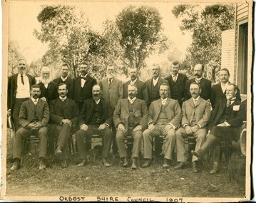
black and white photograph, Howard D. Bulmer, 1907
This photograph shows the Orbost Shire Council in 1907. In the back row are : A. Hillyard; John Draffin (sec.); David Jonson; Archie Rodwell; Hugh Cameron; Geotge Nixon; J. Hassett; Percy Watt; Wm Anderson (engineer); Wm Ross (S.R. Mail) Seated in front on chairs are : Sam Lynn; R. Pearse; John Johnston; Henry Luke (pres.); Donald Munro; Bill Cumming; Charles Grove The shire covered an area of 9,347 square kilometres and existed from 1892 until 1994 when it became part of the East Gippsland Shire Council. Orbost was at first included in the Bairnsdale Shire from 1882 and was later part of the Tambo Shire. Because of travelling distances the Croajingalong Shire was created in 1892 (name changed to Orbost Shire 17.2.1893 with James Cameron as the first Shire President. In 1994 it amalgamated to become part of East Gippsland Shire Council.This item is associated with the Orbost Shire Council. The shire covered an area of 9,347 square kilometres and existed from 1892 until 1994 when it became part of the East Gippsland Shire Council. A large black / white photograph of a group of men in two rows - front row seated; back row standing. The photograph has been taken outdoors with trees in the background and to the right a wooden building and tank. There is a copy.on front - "Orbost Shire Council - 1907" on back - "March, 1907, Shire Council"orbost-shire-council-1907 local-government -
 Orbost & District Historical Society
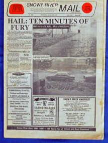
newspaper, Snowy River Mail, 30.1.1991
On 24 January 1991 a severe hailstorm occurred in Orbost. The Insurance Council of Australia estimated the 1991 damage at $12 million. This newspaper records contemporary accounts of significant local events.A Snowy River Mail newspaper, dated 30.1.1991. the main article relates to the severe hail storm in Orbost on January 24, 1991. The newspaper contains news articles, photographs and advertisements.hail-storm-orbost-1991 snowy river mail -
 Orbost & District Historical Society
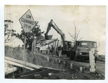
black and white photographs, 1976 - 1977
These photographs are of the demolition of the road bridge across the Snowy River at Orbost. This bridge over the Snowy River was opened on July 4 1922. It was constructed in 1922 alongside the previous suspension bridge. Its building was a combined effort of the Victorian Railways and the Country Roads Board at a cost of 35,000 pounds. It was replaced in 1976 by the present bridge after several major floods.This bridge was replaced in 1976 after several major floods. These photographs are pictorial records of its demolition.Four black / white photographs of the demolition of a road bridge across a river. In them can be seen trucks, excavators and workmen. In 3246.1 there is a triangular road sign - "LOW CLEARANCE 3.9m"bridge-demolition orbost-snwoy-river-bridge -
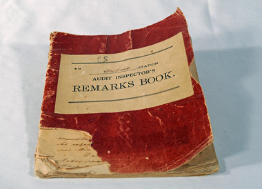 Orbost & District Historical Society
Victorian Railways remarks book, Victorian Railways, c. 1940s
Used at Orbost Railway Station, possibly by the Station Master, between 1944 and 1984. The Bairnsdale-Orbost railway was opened in 1916 to serve the agricultural and timber industry. Because of the decline in traffic and heavy operating costs, the line was finally closed in August, 1987. Orbost Railway Station was opened on Monday 10 April 1916 as the terminus of the Orbost railway line, and closed in 1987. The station was located on the west side of the Snowy River despite the town of Orbost being on the east side of the river, in order to save on the costs of a bridge over the river, which at the time had highly variable levels. This item is associated with the history of the Orbost-Bairnsdale railway line and therefore reflects the role that the rail line played in the social and economic history of Orbost.Book with a red cover. On the front cover VICTORIAN RAILWAYS Audit Inspectors Remarks Book, Orbost. Inside are numbered and lined pages with hand written information dating from 28/3/1944-13/8/1984, dated and signed by various station masters. Cover has a section missing from the bottom left.VICTORIAN RAILWAYS Audit Inspectors Remarks Book, Orbost.railway-history orbost-bairnsdale-railway -
 Orbost & District Historical Society
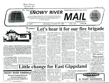
document, Snowy River Mail, Wednesday November 9 1994 (original)
The Orbost Fire brigade was formed in 1919. With the help of some large donated funds a fire station was built in 1920. the foundation leader of ther Brigade was Captain George Hudson with Mr Jack Healey as secretary. A street procession was held on Saturday November 12 as part of the celebrations.This item is associated with the Orbost Fire Brigade an integral part of community support in Orbost. The article is a useful research tool.A copy of a newspaper article from the Snowy River Mail. It is the history of the Orbost Fire Brigade which was celebrating 75 years of service.orbost-fire-brigade -
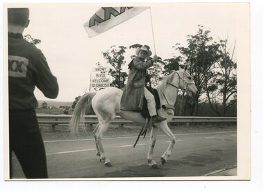 Orbost & District Historical Society
black and white photographs, November 1976
All of these photographs were taken prior to 25th November, 1876, the official opening and crossing of the current Snowy River Bridge. Gary Downey, an Orbost Apeian, did a "De Groot" and crossed the bridge on horseback prior to the official cars crossing the bridge to signal the opening of the new structure. There was a closing ceremony for the old bridge with a group arriving in a 1927 Chrysler, owned by Apexian, Peter Dreverman. This was watched by groups of school students. Some of the Apex members, including Jim Duggan, Noel Smart and Pat Hall, dressed in formal attire to speak to the audience.This event was organised by the Apex Club of Orbost.The Apex Club of Orbost was a volunteer service club which contributed to the Orbost community. A declining population has led to the demise of many social groups in the area.Ten black / white photographs related to the unofficial opening of the Snowy River Bridge at Orbost. snowy-river-bridge-1976 apex-club-orbost ceremony -
 Glen Eira Historical Society
Album - Album page, Glen Huntly Road, Circa 1972
This photograph is part of the Caulfield Historical Album 1972. This album was created in approximately 1972 as part of a project by the Caulfield Historical Society to assist in identifying buildings worthy of preservation. The album is related to a Survey the Caulfield Historical Society developed in collaboration with the National Trust of Australia (Victoria) and Caulfield City Council to identify historic buildings within the City of Caulfield that warranted the protection of a National Trust Classification. Principal photographer thought to be Trevor Hart, member of Caulfield Historical Society. Most photographs were taken between 1966-1972 with a small number of photographs being older and from unknown sources. All photographs are black and white except where stated, with 386 photographs over 198 pages. From: Glen Eira Heritage Management Plan (1996) by Andrew Ward and Associates Moore's Buildings", were built in 1891 and comprising 5 shops. In 1888, Hugh Moore, a gentleman, subdivided his land in Glen Huntly Road, north side between Selwyn Street and St Georges Road into 27 lots, with a right of way separating them from his property "Glenmoore". The subdivision was known as the "Glenmoore Estate". Purchases of land included local builders Corkill, French and Pugh. Moore retained five lots and W.W. Jamieson bought lots 11 to 14. "Moore' s Buildings are locally important for their association with the early Elsternwick land owner, Hugh Moore, whose home, "Glenmoore", at 1 St.Georges Road (qv) survives. They recall Elsternwick's role in the Land Boom and survive as a most prominent row in the Glen Huntly Road shops, enhanced by the survival of the unpainted stuccoed surfaces to nos. 307-311. 287-289 Glen Huntly Road: contributory to HO72, Elsternwick Estate and Environs, City of Glen Eira.Page 63 of Photograph Album with one landscape photograph of retail shops (Moore's Buildings).Hand written: 287-289 Glen Huntly Road [under photo] / 63 [bottom left] trevor hart, shop, grocer, stuccoed, terrace, victorian terrace, protruding parapet, ornate render, hugh moore, 1890's, moore's buildings, glenmoore, glenmoore estate, shopping centres, milk bars, cars, victorian style, glen huntly road, glenhuntly road, elsternwick -
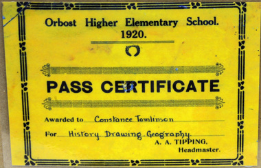 Orbost & District Historical Society
certificate, Phillips, John, 2012
This certificate for the Orbost Secondary College Centenary Celebrations on Saturday 28th April and Sunday 29th April 2012. Connie Tomlinson was the daughter of Tomlinson, John (Mr) who worked in Temple's then Herbert's store, then his own business - very keen worker for starting Orbost Hospital. Father was also seecretary of Loyal Orbost Lodge for 21 years.Miss Tomlinson owned Connort (now Moogji building) and worked as a secretary at the Orbost Shire Council.Orbost High School / Orbost Secondary College has played a significant part in the education of senior students in the Orbost district . It is the sole senior educational institution. This certificate is representative of its history.A laminated copy of Orbost Higher Elementary School 1920 Pass Certificate. It was awarded to Constance Tomlinson for History Drawing Geography and is signed by A.A. Tipping (headmaster)On back : Produced by John Phillips for the Orbost Secondary College Centenary Celebrations on Saturday 28th April and Sunday 29th April 2012certificate education orbost tomlinson-connie -
 Glen Eira Historical Society
Album - Album page, Normanby Road, Circa 1972
This photograph is part of the Caulfield Historical Album 1972. This album was created in approximately 1972 as part of a project by the Caulfield Historical Society to assist in identifying buildings worthy of preservation. The album is related to a Survey the Caulfield Historical Society developed in collaboration with the National Trust of Australia (Victoria) and Caulfield City Council to identify historic buildings within the City of Caulfield that warranted the protection of a National Trust Classification. Principal photographer thought to be Trevor Hart, member of Caulfield Historical Society. Most photographs were taken between 1966-1972 with a small number of photographs being older and from unknown sources. All photographs are black and white except where stated, with 386 photographs over 198 pages. From: Glen Eira Heritage Management Plan (1996) - Vol 2 by Andrew Ward and Associates The widening of Dandenong Road during the late 1980's has resulted in the destruction of the houses in the path of the roadworks and the construction of a high fence serving as a visual barrier between that thoroughfare and the remaining houses. Where comparatively large villas once stood on spacious allotments, only "Wisteria" survives at No. 135 Normanby Road. Adopting forms and timber enrichment characteristic of the American Queen Anne style, it has this in common with the largely reconstructed timber villa at no. 11 Normanby Avenue and to a lesser extent, 746 Inkerman Road. Normanby Road retains its comparatively opulent Edwardian character in a mature landscaped setting with spacious gardens and mature planes parallel with the railway reserve which, on account of the low lying ground in its vicinity has a high embankment commencing on the alignment of Malvern Grove and continuing to Caulfield Station. The earliest villas are Edwardian. Page 148 of Photograph Album with one landscape photograph of a house on Normanby Road (not Street).Handwritten: Normanby St [top right] / 148 [bottom right]trevor hart, verandah, porch, bull nosed verandah, tower house, tower, stone fence, normanby road, wisteria, american queen anne style, queen anne style, 1890's, mayfield grove, normanby street, timber houses, caulfield north, house names, edwardian, edwardian style, gardens -
 Orbost & District Historical Society
black and white photograph, Warren, Mrs H, first half 20th century
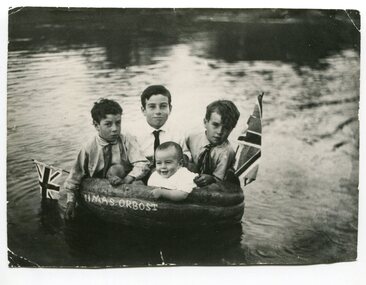
This is a photograph of Alan, Keith, Preston and Jim Nixon. George Nixon (1862-1941) selected land in Bete Bolong in the 1890's. He married Emily Warren in 1889 in Orbost. He was a shire councillor. He was a prominent breeder of Clydesdales and after a serious fall off a horse walked with a walking stick and special boot for the rest of his life. He was well-known for his interest in cars, horse-racing and politics.He was married to Emily Warren in 1889 in Orbost. Mrs Nixon (Emily)was the first Red Cross president during WW1. They had ten children.both George and Emily are buried in the Orbost Cemetery. (ref:From White Knowle to Pumpkin Point by Hon Peter Nixon A.O.) The photographer was Warren, Helena (1871-1962) who was a self-taught photographer who became both the local press correspondent and a producer of humorous trompe l'oeil postcard images. Helena Warren was a thirty-two year old settler living on a small mixed farm with her husband, William, at Newmerella, near Orbost in Gippsland, Victoria, when she bought her first camera, an Austral Box quarter-plate. Her family says she was entirely self-taught, like many women photographers who started out with nothing but the instructions on the packets of film and chemicals. In over fifty years practice she graduated from the total novice, who opened all her first mail order plates in bright sunlight and ruined them, to a competent photographer who became both the local press correspondent and an inveterate producer of humorous trompe l’oeil postcard images.This photograph has significance in its association with Helen Frances Warren, a popular Orbost identity who was well known as an accomplished photographer and needleworker, This item is also associated with a prominent Orbost family. George Nixon was the son of James and Alice Nixon. The Nixon families were among the earliest settlers on the Snowy River. It is an example of the early book-keeping of an Orbost business in the early 20th century.A black / white photograph of three boys and a baby in a carved out pumpkin with a flag at each end and "HMAS ORBOST" carved in the front.warren-helena pumpkins nixon -
 Orbost & District Historical Society
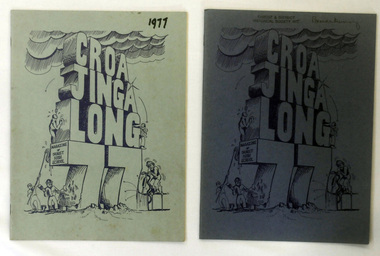
magzines, Croajingolong 1977, 1977
This is the thirtieth issue of the annual Orbost High School magazine. The name Croajingolong derives from the Australian Aboriginal Krauatungalung words galung, meaning "belonging to" and kraua, meaning "east. 2225.1 belonged to Mary Gilbert, a former teacher at the school. 2225.2 belonged to Brenda Murray, a former mayor of East Gippsland Shire and prominent Orbost resident.This magazine is a useful reference tool.Two copies of the magazine, Croajingolong 1977. 2225.1 has a torquoise cover and 2225.2 has a mid blue cover. Both have a large graphic design on the front cover of CROAJINGOLONG 1977 created in stone with 5 workers chizeling and polishing the structure. There are heavy clouds above. Contents are type-written.2225.2 has Brenda Murray handwritten in pen on the front cover as well as the stamp of the Orbost Historical Society.croajingolong orbost-high-school -
 Orbost & District Historical Society
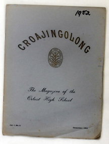
magazine, Croajingolong 1952, 1952
This is the fifth issue of the Orbost High School annual magazine. The name Croajingolong derives from the Australian Aboriginal Krauatungalung words galung, meaning "belonging to" and kraua, meaning "east". This magazine belonged to Mary Gilbert, a former teacher at the school.This fifth issue of the annual Orbost High School magazine is a useful reference tool.A grey covered magazine of 32 pp. On the front cover is the text Orbost High school Croajingolong 1952 Dec. 1952 Vol.1 No.5croajingolong orbost-high-school -
 Orbost & District Historical Society
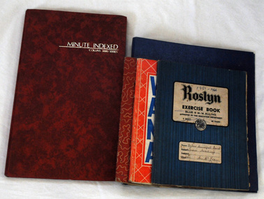
books, 1963-1979
These books were used by the Ladies' Auxiliary of the Orbost Municipal Band.The various Orbost bands over the years played a major role in community activities providing entertainment and musical experiences for the many members. One blue-covered folder containing inward correspondence. Three exercise books ( one blue and two red) and one red covered ledger book which contain minute of the Ladies' Auxiliary of the Orbost Municipal Band.orbost-municipal-band correspondence documents -
 Orbost & District Historical Society
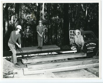
VR Printing Works, 1975
The three men in this photograph, one of a set of six), are all from the Donchi family who have been involved in sleeper - cutting since the 1890s. From left to right they are Brian, Ken and Alan Donchi. The photograph was taken for an article in the Victorian Railways Magazine in 1975, a pamphlet produced for Victorian Railways. It contains photographs and an article about Orbost as "Timber Country" and a detailed article titled, " Cutting Sleepers is a Family Business" which tells about the Donchi family.This photograph is associated with the timber and sleeper-cutting industry in the Orbost Region. Timber sleepers were superceded by concrete sleepers in c. 1970s. Orbost has historically been based on the timber industry, but that industry has declined considerably over the last 20 years..The number of locals involved in the timber industry has declined and many of the mills have closed. This item reflects a time when that industry was a significant contributor to the economy of the district.A black / white photograph of three members of the Donchi family working at sleeper - cuttingin a timber coupe in Orbost.on back - Pr 8764timber-industry-orbost sleeper - cutting donchi-family-orbost -
 Marysville & District Historical Society
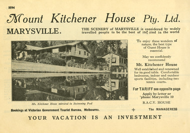
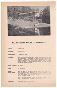
Ephemera (item) - Information booklet advertisement, Broadbent's Official Road Guides Company, MT. KITCHENER HOUSE - MARYSVILLE, Unknown
An advertisement for Mount Kitchener House in Marysville taken from a Broadbent's accommodation guide.An advertisement for Mount Kitchener House in Marysville taken from a Broadbent's accommodation guide.marysville, victoria, australia, mount kitchener house, mt kitchener house, kitchener house, accommodation, broadbent's accommodation guide -
 Marysville & District Historical Society
Ephemera (item) - Information booklet advertisement, Broadbent's Official Road Guides Company, MT. KITCHENER HOUSE - MARYSVILLE, Unknown
A digital copy of an advertisement for Mount Kitchener House in Marysville that was taken from a Broadbent's accommodation guide.A digital copy of an advertisement for Mount Kitchener House in Marysville that was taken from a Broadbent's accommodation guide.marysville, victoria, australia, mount kitchener house, mt kitchener house, kitchener house, accommodation, broadbent's accommodation guide -
 Marysville & District Historical Society
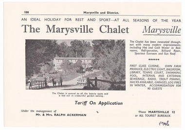
Ephemera (Item) - Information booklet advertisement, Broadbent's Official Road Guides Company, The Marysville Chalet, 1948
An advertisement for The Marysville Chalet guest house in Marysville taken from a Broadbent's accommodation guide.An advertisement for The Marysville Chalet guest house in Marysville taken from a Broadbent's accommodation guide.marysville, victoria, australia, the marysville chalet, guest house, poontawan, steavenson hotel, albert harrison, margaret harrison, elise ackerman, ralph ackerman, john van ranglerooy, joe keithard, kathy keithard, louisa goding, accommodation, broadbent's accommodation guide