Showing 569 items matching "project planning"
-
 Kew Historical Society Inc
Plan - Subdivision Plan, Raheen Estate Subdivision, 1960
... was being sold to finance school building projects. Raheen Estate ...Subdivision plans are historically important documents used as evidence of the growth of suburbs in Australia. They frequently provide information about when the land was sold on which a built structure was subsequently constructed as well as evidence relating to surveyors and real estate and financial agents. The numerous subdivision plans in the Kew Historical Society's collection represent working documents, ranging from the initial sketches made in planning a subdivision to printed plans on which auctioneers or agents listed the prices for which individual lots were sold. In a number of cases, the reverse of a subdivision plan in the collection includes a photograph of a house that was also for sale by the agent. These photographs provide significant heritage information relating house design and decoration, fencing and household gardens.The Raheen Estate Subdivision of 1960 involved the creation of 36 residential allotments and the sale of 34 of these. The land on which the subdivision was created had until 1960 formed part of the grounds of the mansion Raheen in Studley Park Road. In 1917, the Catholic Church had purchased Raheen and its lands. It was to become the home of Archbishop of Melbourne, Daniel Mannix, for 46 years. The sale of the subdivision took place three years before the Archbishop’s death. Subsequent archbishops were to reside at Raheen until its sale to the Pratt family in 1981. When the sale of the Estate was reported in the newspapers in 1960, it was described as the last big subdivision near Melbourne. At the auction, 33 of the 36 allotments were sold. The auction realised £315,750. Purchasers were advised that the vendor intended to keep lots 22 and 23. The alllotments in the subdivision required the construction of new roads. These included Eamon Court and Raheen Drive. The justification provided by the Church for the sale was that the estate was being sold to finance school building projects.subdivision plans - kew, studley park, raheen estate, eamon court, studley park road, coombes avenue, raheen drive -
 Kew Historical Society Inc
Plan - Subdivision Plan, High Street, Kew, 1920-1935
Pru Sanderson, in her groundbreaking ‘City of Kew Urban Conservation Study : Volume 2 - Development History’ (1988), summarised the periods of urban development and subdivisions of land in Kew. The periods that she identified included 1845-1880, 1880-1893, 1893-1921, 1921-1933, 1933-1943, and Post-War Development. These periods were selected as they represented periods of rapid growth or decline in urban development. An obvious starting point for Sanderson’s groupings involved population growth and the associated economic cycles. These cycles also highlighted urban expansion onto land that was predominantly rural, although in other cases it represented the decline and breakup of large estates. A number of the plans in the Kew Historical Society’s collection can also be found in other collections, such as those of the State Library of Victoria and the Boroondara Library Service. A number are however unique to the collection.The Kew Historical Society collection includes almost 100 subdivision plans pertaining to suburbs of the City of Melbourne. Most of these are of Kew, Kew East or Studley Park, although a smaller number are plans of Camberwell, Deepdene, Balwyn and Hawthorn. It is believed that the majority of the plans were gifted to the Society by persons connected with the real estate firm - J. R. Mathers and McMillan, 136 Cotham Road, Kew. The Plans in the collection are rarely in pristine form, being working plans on which the agent would write notes and record lots sold and the prices of these. The subdivision plans are historically significant examples of the growth of urban Melbourne from the beginning of the 20th Century up until the 1980s. A number of the plans are double-sided and often include a photograph on the reverse. A number of the latter are by noted photographers such as J.E. Barnes.A roughly drawn and faded actual or projected subdivision of a parcel of land bordering on High and Mary Streets. The plan shows five allotments facing High Street and at their rear, another allotment facing Mary Street. In 1906, when the Board of Works surveyors completed Detail Plan 1589, the allotment in Mary Street is shown to include a building. The section of land attached to this building is shown to be undeveloped, thus making a further subdivision possible.subdivision plans - kew, high street -- kew (vic.), mary street -- kew (vic.) -
 Kew Historical Society Inc
Plan - Subdivision Plan, Corsewall Estate, Hawthorn, 1938
The Kew Historical Society collection includes almost 100 subdivision plans pertaining to suburbs of the City of Melbourne. Most of these are of Kew, Kew East or Studley Park, although a smaller number are plans of Camberwell, Deepdene, Balwyn and Hawthorn. It is believed that the majority of the plans were gifted to the Society by persons connected with the real estate firm - J. R. Mathers and McMillan, 136 Cotham Road, Kew. The Plans in the collection are rarely in pristine form, being working plans on which the agent would write notes and record lots sold and the prices of these. The subdivision plans are historically significant examples of the growth of urban Melbourne from the beginning of the 20th Century up until the 1980s. A number of the plans are double-sided and often include a photograph on the reverse. A number of the latter are by noted photographers such as J.E. Barnes.This is a second, more complete version of the Corsewall Estate subdivision that is held by the Society. The Coreswall Estate was a subdivision, bordering on Barkers Road and Auburn Road, which created Corsewall Close. This relatively late subdivision included 29 allotments. The subdivision plan includes the dimensions of each lot as well as the width of the existing and projected roads and turning circles. The Corsewall Close Precinct is now listed on the Victorian Heritage Database (HO147) and is noted for its ‘consistent flat-type development over the entire street, which has been cleverly designed to make multi-unit dwellings appear as single buildings’. In this second version of the plan, the rarity of this late subdivision is emphasised by the auctioneers. The original plan must have contained a photograph, which is unfortunately truncated here.subdivision plans - hawthorn, corsewall estate -
 Kew Historical Society Inc
Plan - Subdivision Plan, Corsewall Estate, 1938
The Kew Historical Society collection includes almost 100 subdivision plans pertaining to suburbs of the City of Melbourne. Most of these are of Kew, Kew East or Studley Park, although a smaller number are plans of Camberwell, Deepdene, Balwyn and Hawthorn. It is believed that the majority of the plans were gifted to the Society by persons connected with the real estate firm - J. R. Mathers and McMillan, 136 Cotham Road, Kew. The Plans in the collection are rarely in pristine form, being working plans on which the agent would write notes and record lots sold and the prices of these. The subdivision plans are historically significant examples of the growth of urban Melbourne from the beginning of the 20th Century up until the 1980s. A number of the plans are double-sided and often include a photograph on the reverse. A number of the latter are by noted photographers such as J.E. Barnes.The Corsewall Estate was a subdivision, bordering on Barkers Road and Auburn Road, which created Corsewall Close. This relatively late subdivision included 29 allotments. The subdivision plan includes the dimensions of each lot as well as the width of the existing and projected roads and turning circles. The Corsewall Close Precinct is now listed on the Victorian Heritage Database (HO147) and is noted for its ‘consistent flat-type development over the entire street, which has been cleverly designed to make multi-unit dwellings appear as single buildings’.subdivision plans - hawthorn, corsewall estate -- hawthorn (vic.) -
 Kew Historical Society Inc
Book, McPhee Gribble, Living Places: twenty houses, 1987
Photographic project commissioned by The State Library of Victoria. "Two hundred of the four hundred photographs taken for the project are to be found at the State Library of Victoria ..."--Introd., p. 6.Fitzroy, Vic. : McPhee Gribble/Penguin, 1987 218 p. : ill., plans ; 21 x 25 cm. non-fictionPhotographic project commissioned by The State Library of Victoria. "Two hundred of the four hundred photographs taken for the project are to be found at the State Library of Victoria ..."--Introd., p. 6.housing -- australia, dwellings -- australia -- social aspects -
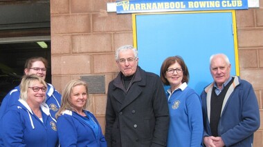 City of Warrnambool Rowing Club
Development Plaque, 16 july 2017
The people are L to R: Kathy McMeel (secretary), Annie Blanch (Boat Captain), Joanne Bone (president), James Tait (director of Gwen and Edna Jones and Ray and Joyce Uebergang Foundations, Susan Finnigan (Grants Officer) and Clive Wooster (treasurer). • In February 2017 the club filled the base of the boathouse and poured a new concrete floor. • They had an opening to thank the donors, especially the Gwen and Edna Jones and Ray and Joyce Uebergang Foundations and to celebrate with the community and rowers, past and present • Since 1996 rowers had to wade in foul, ankle to thigh high water to access the boat shed- this was for 3-5 months of every year- our facilities are now accessible and Warrnambool has a sporting venue for rowers that is safe and one the public can be proud of. • The Club thanked Barry Wilson for generously donating the plans and acknowledged the ‘term deposit’ raised over the last 10 years, by past and present members, which allowed the Club to contribute the additional funding required. • In particular The Foundations assistance made the project possible. The two philanthropic Foundations are a treasure for the community as they can step in and fill the gap where other funding sources cannot. In our case they were the major donors and we could not have contemplated this project without their assistance. We are truly grateful for the assistance of The Gwen and Edna Jones and Ray and Joyce Uebergang Foundation. • Mr James Tait, a director of both Foundations to unveiled the commemorative plaque. Color photograph taken at the opening of the Redeveloped City of Warrnambool Rowing Club. Includes a brass plaque. The people are L to R: Kathy McMeel (secretary), Annie Blanch (Boat Captain), Joanne Bone (president), James Tait (director of Gwen and Edna Jones and Ray and Joyce Uebergang Foundations, Susan Finnigan (Grants Officer) and Clive Wooster (treasurer).james tait, warrnambool, city of warrnambool rowing club, warrnambool rowing club, boathouse, boathouse redevelopment, gwen and edna jones foundation, ray and joyce uebergang foundation -
 Glen Eira City Council History and Heritage Collection
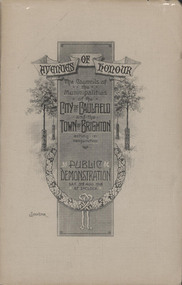
Booklet, "AVENUES OF HONOUR The Councils of the Municipalities of the CITY OF CAULFIELD TOWN OF BRIGHTON acting in conjunction PUBLIC DEMONSTRATION SAT 3rd AUG. 1918 AT 3oCLOCK"
Souvenir Programme from the Councils of the Municipalities of the City of Caulfield and the Town of Brighton for a Public Demonstration to be held on Sat 3rd August 1918 at 3 o'clock for the proposed Avenues of Honour to be planted in memory of fallen WWI soldiers. From Honour Roll Display 2019 interpretation panel - Brighton-Caulfield Avenue of Honour It is hard to imagine but a grand arboreal Avenue of Honour once lined parts of North Road, McMillan Street and Point Nepean Road (now Nepean Highway). The Avenue of Honour was a distinctly Australian phenomenon with hundreds being constructed throughout Australia during and following World War One, most of these in Victoria. Consisting of tree lined streets with each tree representing a solider, the Avenue of Honour signalled a more egalitarian approach to commemoration where rank was not a consideration. Arguably the most famous Avenue of Honour in Victoria still exists at Ballarat. Stretching for nearly 22 kilometres, the entrance to the Avenue is marked by the imposing Arch of Victory. Smaller in scale, the Brighton-Caulfield Avenue of Honour was dedicated to the ‘memory of (Brighton and Caulfield’s) kith and kin who came from (the) district and who died in the Great War’. A joint project between the neighbouring Councils, the idea was first reported in The Argus on 1 July 1918. Plans moved along quickly and on 3 August 1918 the Governor of Victoria Arthur Stanley planted the first Australian flowering gum. The next of kin were then invited to plant trees for lost sons, brothers, uncles, nephews and husbands. In all, over 400 trees were planted. Intensely personal, the Avenue also acted as a focus of grief and remembrance for the wider community. For many years, the annual civic Anzac Day service was held at the Avenue on Point Nepean Road, near Glen Huntly Road, Elsternwick. The service was moved to Caulfield Park upon the completion of the Cenotaph in 1930. Due to road widening and disease the last original tree was replaced in the 1980s, however a plaque in Caulfield Park records the Avenue’s plantation. Commemorative booklet, grey cover with text printed on the grey textured paper cover and an image of four trees and a wreath. Image of a kookaburra on the back. Inside, 28 numbered pages with b/w text and photographic images including a transparent paper representation of the proposed Avenues of Honour on Brighton Road and Point Nepean Road. Souvenir programme for a Public Demonstration for the Avenues of Honour as detailed on the front.city of caufield, world war one, first world war, anzac, remembrance, town of brighton, brighton, caulfield, avenue of honour -
 Glen Eira City Council History and Heritage Collection
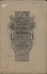
Booklet, D. W. Paterson Co. Pty. Ltd, "AVENUES OF HONOUR The Councils of the Municipalities of the CITY OF CAULFIELD TOWN OF BRIGHTON acting in conjunction PUBLIC DEMONSTRATION SAT 3rd AUG. 1918 AT 3oCLOCK SOUVENIR"
Souvenir Programme from the Councils of the Municipalities of the City of Caulfield and the Town of Brighton for a Public Demonstration to be held on Sat 3rd August 1918 at 3 o'clock for the proposed Avenues of Honour to be planted in memory of fallen WWI soldiers. One of two known copies, this copy has "Town Clerk" stamped in the upper corner, rhs.Commemorative booklet, grey cover with text printed on the grey textured paper and an image of four trees and a wreath. Image of a kookaburra on the back. Inside, 28 numbered pages with b/w text and photographic images including a transparent paper representation of the proposed Avenues of Honour on Brighton Road and Point Nepean Road. Souvenir programme for a Public Demonstration for the Avenues of Honour as detailed on the front. From Honour Roll Display 2019 interpretation panel - Brighton-Caulfield Avenue of Honour It is hard to imagine but a grand arboreal Avenue of Honour once lined parts of North Road, McMillan Street and Point Nepean Road (now Nepean Highway). The Avenue of Honour was a distinctly Australian phenomenon with hundreds being constructed throughout Australia during and following World War One, most of these in Victoria. Consisting of tree lined streets with each tree representing a solider, the Avenue of Honour signalled a more egalitarian approach to commemoration where rank was not a consideration. Arguably the most famous Avenue of Honour in Victoria still exists at Ballarat. Stretching for nearly 22 kilometres, the entrance to the Avenue is marked by the imposing Arch of Victory. Smaller in scale, the Brighton-Caulfield Avenue of Honour was dedicated to the ‘memory of (Brighton and Caulfield’s) kith and kin who came from (the) district and who died in the Great War’. A joint project between the neighbouring Councils, the idea was first reported in The Argus on 1 July 1918. Plans moved along quickly and on 3 August 1918 the Governor of Victoria Arthur Stanley planted the first Australian flowering gum. The next of kin were then invited to plant trees for lost sons, brothers, uncles, nephews and husbands. In all, over 400 trees were planted. Intensely personal, the Avenue also acted as a focus of grief and remembrance for the wider community. For many years, the annual civic Anzac Day service was held at the Avenue on Point Nepean Road, near Glen Huntly Road, Elsternwick. The service was moved to Caulfield Park upon the completion of the Cenotaph in 1930. Due to road widening and disease the last original tree was replaced in the 1980s, however a plaque in Caulfield Park records the Avenue’s plantation. Inkstamp upper corner rhs: "TOWN CLERK" -
Glen Eira City Council History and Heritage Collection
Document (Item) - Newspaper (digital), Caulfield Contact
The Caulfield Contact was the official newspaper of the City of Caulfield from 1976-1994. The City of Caulfield was the Municipal Council for an area of the South Eastern suburbs of Melbourne, including Brighton East, Carnegie, Caulfield, Elsternwick, Gardenvale, Glen Huntly, McKinnon, Murrumbeena, Ormond and St Kilda East. Following Amalgamation of City of Caulfield and parts of the City of Moorabbin in 1994, the Caulfield Contact was followed by the Glen Eira News. Contains References to the following Freedom of Entry to 3rd ordinance of the RAAOC, visit by Sir Zelman Cowen, Return to Rosstown, A 'spacy new home' (nursery at Caulfield Park), Profile on Gus Theobold, Meals on Wheels Aviary completed Caulfield Park. Profile resident Gus Theobold. Cr Irene Capek win Herald Australia Day essay prize. Caulfields Meals on Wheels set Victorian record. Historical feature Return to Rosstown. New ambulance station Glenhuntly and Clarinda roads opens. Volume 4 Number 5 Date 03 August 1978 Features Where and How to Vote in council election. Cr Irene Capek retires from council. Profiles election candidates. Image: Image Cr Irene Capek. Images of election candidates. Volume 5 Number 1 Date 14 September 1978 Freedom of Entry to 3rd ordinance of the RAAOC, visit by Sir Zelman Cowen, Subjects from Carol: GG Sir Zelman Cowen and Lady Cowen offical visit. Off street carpark project underway Pyne St and Hawthorn Rd. City Manager Graeme Caldwell submits plans for Townhall renovations. Action plan for development of Elsternwich Shopping precint to be developed. Freedom of Entry ceremony. Profile Rosemary Keppel. Booran Motors Glenhuntly donate dual control Holden Gemini to Caulfield Tech school pre-driver education program. council election results. Comments from elected Crs Jack Campell, Bob Baxter, Dorothy Ford, Brian Rudzki. Promotion of Caulfield Institute of Technology and TAFE. Image: Image Sir Zelman Cowen, Lady Cowen. Images Freedom of Entry ceremony and citizens attending. Image Rosemary Keppel. Cartoon pre-driver education program. Image Mayor Cr Geoff Patience in robes. Volume 5 Number 2 Date 26 October 1978 Rate rise 5.73% announced. Readership of Caulfield Contact surveyed. Caulfield ranger Reg Dixon and members of works dept rescue duck family from drain and reinstate them to Caulfield Racecourse dam. Profile resident and teacher Claire Manning. Image: Image of Reg Dixon and the rescued ducks. Image Claire Manning and students at Waverley Private school. city of caulfield, caulfield, glen eira, city of glen eira, caulfield contact, freedom of entry to 3rd ordinance of the raaoc, visit by sir zelman cowen, return to rosstown, a 'spacy new home' (nursery at caulfield park), profile on gus theobold, meals on wheels -
Stawell Historical Society Inc
Instrument - Realia, Engineering Instruments from Northern Grampians Shire
1: Small cardboard box with lid containing Silver distance Measurer. This was used for Measuring distances on plans.(Planimeter) 2: Cardboard Box without lid containing three plumbobs: One large turned brass: one small turned metal. One circular silver coloured metal complete with string and winding board. These were used to locate survey equipment above a fixed point. 3: Timber ( Vic Ash?) dovetailed box with brass hinged lid and brass swing catches containing plywood templates called railway curves, used for drawing curves on plans. 4: Cardboard box with lid containing Allbrit panimeter in Bakelite/plastic box with silver metal hinges and catches "Shire of Kara Kara" inscribed on the box. The box contains the original Instructions. The Planimeter was used for calculating areas of Irregular shapes and used for estimating quantities from plans of cut and fill projects, as one example. 5: Timber Box with brass hinges and swing catches wand leather carry Strap containing one set of self adjusting level made by E.R. Watts and Son, London England. Paper label on the inside "Shire of Stawell". Also had paper instructions pasted to the inner lid. The level was used for taking Ground Levels. The first 3 have been in use up until the 1990's, when computer drafting took over the role of these instruments with greater speed and accuracy. The dumpy level would have been superseded in the 1980's when automatic levels became cheaper, and were more accurate. stawell -
 Surrey Hills Historical Society Collection
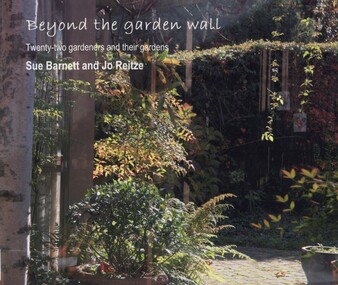
book, Beyond the garden wall: twenty-two gardeners and their gardens, 2008
This book was compiled by Sue Barnett at the request of the project participants from material gathered as part of the project "Beyond the Garden Wall". This project was devised and managed by a team at Surrey Hills Neighbourhood Centre Inc. with funding from the Victorian Department of Planning and Community Development (VDPCD) under the "Images of Age' grant 2007. It involved conducting oral histories, reflection on the part of the participants through visual diaries, photography and painting. A short video of some of the gardens was also commissioned. All the elements came together during Seniors Festival in an exhibition held at the Augustine Centre, and opened by Jane Edmanson. At the request of the VDPCD, a modified exhibition was held in 2008 at 'Australia on Collins' during the 2008 Seniors Festival. Sue Barnett and Jo Reitze (Mrs de Carteret) are Surrey Hills residents. This provides a snapshot of 20 gardens and the 22 passionate gardeners who created them. The prose provides a potted history of the gardeners and their philosophical approach, accompanied by portraits of them and cameo photos of their gardens, as well as a photo of the painting of the garden as seen by artist Jo Reitze. All the gardens were situated within the City of Boroondara and all the gardeners were over 60 years of age. Prose written by Sue Barnett; photography by Sue Barnett and Jo Reitze.gardening, anecdotes, (ms) jo reitze, (ms) susan barnett, sue barnett, paintings, gardeners -
 Surrey Hills Historical Society Collection
Compact disc, Susan Jane Mercy Barnett et al, Beyond the garden wall: twenty-two gardeners and their gardens, 2008
This film documents part of the project "Beyond the Garden Wall". It was devised and managed by a team at Surrey Hills Neighbourhood Centre Inc. with funding from the Victorian Department of Planning and Community Development under the "Images of Age' grant 2007.This video presentation focuses on gardening and its place in the lives of 22 seniors from across the City of Boroondara. The owners of the gardens speak about their earliest recollections of gardens and gardening, influences and inspiration, benefits and frustrations and above all its pleasures.gardening, boroondara, anecdotes, (ms) jo reitze, (ms) susan barnett, taxidermist, gardens, glenburn bend park, birds, (ms) julie morrison, (ms) ann scally, (mr) gary hegedus, (ms) nola sharp, (ms) carol blackett-smith, (ms) sheryl pascoe -
 Surrey Hills Historical Society Collection
Compact disc, Beyond the Garden Wall Project Powerpoint presentation, Dec 2008
Date Made :Dec 2008 Region/State Made: Surrey Hills Selected photographic record as a powerpoint presentation. Part of the acquitted reporting back to DPCD (Dept of Planning and Community Development)Selected photographic record as a powerpoint presentation. Part of the acquitted reporting back to DPCD (Dept of Planning and Community Development)gardening, gardeners, gardens-boroondara -
Round the Bend Conservation Co-operative
The Co-op was fortunate to have members with the professional skills to design, plan, cost, negotiate and organize this project effectively resulting in minimal impact on the land
-
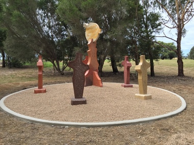 Federation University Art Collection
Sculpture, 'Mungo Moon' by Don Barrett, 2015
'Mungo Moon' by Don Barrett is the first sculpture erected on the Churchill Art and Culture Pathway. It was officially unveiled by Professor David Battersby on 15 April 2015 From Churchill & District News 16 October 2014 The Churchill Art and Culture Walking Pathway will have its official public opening on Saturday October 18, with a walk finishing at Federation University Australia’s Switchback Gallery at the Federation University Gippsland Campus. ... An important link on the newly developed pathway was recently completed with a path south of the FedUni Student West Residences. The path now allows walkers to turn off the Eel Hole Creek path before reaching Glendonald Estate and to follow a picturesque, tree lined walkway to join up with the footpath on the Eastern side of Northways Road. From there the footpath joins into Federation University’s network of walking paths that proceeds past the Switchback Art Gallery, down through the pine plantation and along Lake Kretlow and the Churchill Golf Course. Project Manager Mike Answerth, said the opening of the West Residences section of the path means there is now only one short link to complete. “We’re now very close to realising the project’s objective to join up all these walking paths to provide a continuous pathway that encompasses town, campus and parkland. The next stage of the project will be the completion of Latrobe City’s East West Link and the enhancement of the walking path with artistic and cultural features.” said Mr. Answerth. Head of Federation University Australia Gippsland Campus, Dr Harry Ballis, said the project had been made possible through the contributions of the five former Gippsland Education Precinct (GEP) partners. “The Art and Culture Pathway represents another important step in joining the Churchill township and the university campus as a physical and social entity,” Dr Ballis said. “This was an initiative of the GEP and it is pleasing to see it coming to fruition.” The path now reaches as far as the golf driving range but plans are already under way to connect with the Mathison Park board walk and pathway, which surrounds Lake Hyland in Churchill. When the loop is completed, residents and visitors will have an approximately 5km circular walking path which links up the Churchill town centre, Federation University Australia and Mathison Park. There are already art features along this route, including primary schools’ Bug Blitz totems near the Kurnai College school crossing, native vegetation and history panels near the Hare Homestead in Mathison Park, and outdoor sculptures in the pine trees near the Federation University Switchback Gallery. contemporaryA large sculpture in five pieces set in an external location. It is part of the Churchill Art and Culture Walking Pathway. Don Barrett’s work is mainly in concrete with added coloured oxides to portray the feeling of the Australian landscape. Barrett focuses on concepts of Australia’s short history and indigenous history. churchill art and culture pathway, barrett, don barrett, gippsland campus, federation university, churchill, sculpture -
 University of Melbourne, Burnley Campus Archives
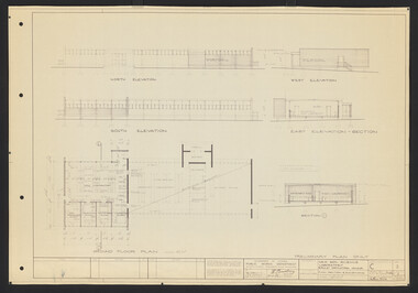
Plan, L.R.B. Simmons, New Soil Science Laboratory, 1973
Plans by Govt. Of Victoria Public Works Dept.: L.R.B. Simmons (Senior Project Architect), D.C. Bradbury (Chief Architect), Drawn by Aldo Bellarmo. A. Proposed addition to existing laboratory. B. Plan of Section and Elevation of proposed new Soil Science laboratory.laboratory, glasshouse, l.r.b. simmons, d.c. bradbury, aldo bellarmo -
 University of Melbourne, Burnley Campus Archives
Plan, Rainforest Garden Development VCAH Burnley, 1990-1992
Some of these plans were held in P. Tulk's office, used by Honours Student, Linda Hipwell in 1999. (1a) Rough sketch on tracing paper. (1) Rainforest Project drawn by G. Olive, rough sketch pen and pencil on paper. (2) 1 tracing paper and 2 paper copies, Rainforest Garden Development Plant Schedule Key by type of plant. (3) Blueprint of Rainforest Garden Development, plant names beside plants, note to P. Tulk from J. Kellow. (4) Native Garden Burnley VCAH Hort Eng. II. Surveying by Gail, John, Rebecca, Sean, Tim (Students). g. olive, phil tulk, linda hipwell, vcah, students, rainforest, gardens -
University of Melbourne, Burnley Campus Archives
Plan, Royal Children's Hospital, 1989-1991
(1) Landscape Concept Royal Children's Hospital by Bates Smart and McCutcheon. (2) Tracing paper Sketch Plan. Scale 1:250 dated 29.3.90 by Jill Kellow. (3) Garden Project, The Foundation Royal Children's Hospital by Denise L. Stephens, DLS Design. Sheet 6 of 7, May 1990. Scale 1:100. (4) Photocopy of Surfaces and Playground Equipment, Royal Children's Hospital, August 1991. No 9046/01. Scale 1:100. (5) Photocopy of Surfaces and Playground Equipment, Royal Children's Hospital, August 1991. No 9046/02. Drawn By R.K. Scale 1:100.royal children's hospital, bates smart, jill kellow -
University of Melbourne, Burnley Campus Archives
Plan, S. Soerono, Project Xerophytic Garden, 1989
... . Soerono, dated 10.11.1989 Project Xerophytic Garden Plan S ...Planting Plan and Coloured Elevation from Pt A to A₁ by S. Soerono, dated 10.11.1989s. soerono, landscape design, xerophytic gardens -
 Federation University Art Collection
Artwork, other - Artwork, 'Reconciliation' by Shanaya Sheridan and Josh Muir, 2018
This artwork was created in collaboration by Shanaya Sheridan and Josh Muir in 2018. Josh Muir was a proud Yorta Yorta, Gunditjmara and Barkinji man, who holds his culture close to his heart as it gives him a voice and great sense of identity. Josh is a Ballarat-based multimedia artist. In 2015 Josh was the recipient of the Telstra National Indigenous and Torres Strait Islander Art Award – Youth Award and the Hutchinson Scholarship, through which he undertook a 12-month residency at the Victorian College of the Arts in Melbourne. Muir's work has been acquired by the Koorie Heritage Trust, The National Gallery of Australia, the Museum and Art Gallery of the Northern Territory, the National Gallery of Victoria and was commissioned as a major project artist by White Night. Shanaya Sheridan, is a proud Yorta Yorta, Dja Dja Wurrung and Boon Wurrung woman who has resided in Ballarat for 20 years, after living in Horsham, Shepparton and Melbourne. Growing up and watching her Elders, and their style of artworks, Shanaya is influenced by a traditional style of Aboriginal art, mixing it up with contemporary colours. This reconciliation piece is Shanaya’s first commission. Artists' Statement: '“This painting represents reconciliation across all lands, from the skies down to the waters including the mountains, grass and sand. The hands represent people of all cultures reaching for a brighter future, and the men and women in talks of how reconciliation can be achieved. Last but not least, the footprints represent our Aboriginal and Torres Strait Islander ancestors that have fought for reconciliation before us and their steps/progress towards reconciliation.' Digital prints of this artwork on aluminum are displayed at Federation University Australia campuses at Mt Helen, Gippsland (Churchill), Berwick, Brisbane and Horsham.reconciliation, josh muir, shanaya sheridan, aboriginal, reconciliation action plan -
 Federation University Art Collection
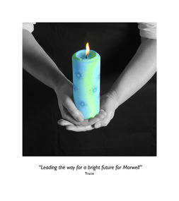
Photograph, Clive Hutchison, 'Our Hopes and Future of Morwell' Photographic Collection, 2017
This photographic exhibition was developed by the Federation University-led Community Wellbeing research stream of the Hazelwood Health Study in collaboration with Morwell Neighbourhood House and Gippsland Centre for Art and Design at Federation University Australia. It highlights people's hopes for the future of Morwell has its roots in two unexpected places: the Hazelwood mine fire in 2014 and an academic study into community recovery from that fire. In late summer of 2014 a bushfire spread to the coal mine near the town of Morwell in the LaTrobe Valley, in south-eastern Victoria. The Hazelwood mine fire burned for 45 days, shrouding communities - especially Morwell - in smoke and ash. Strong calls by the community for an investigation into the health impacts of the Hazelwood Mine Fire led to the Department of Health's (Know the Department of Health and Human Services) decision to fund a ten year study of the potential health effects of this smoke event (Known as the Hazelwood Health Study). This exhibition came out of work undertaken by the Community Wellbeing Stream of the Hazelwood Health Study during 2016 and 2017. Based at Federation University Australia's Gippsland Campus, just a few kilometres from where the fire took place, one of our Study's main aims has been to find out from the community how the smoke event impacted on community wellbeing. We also planned to talk to community members about the effectiveness of community rebuilding activities, and find our how these have aided recovery following the smoke event. In 2017 we began working with community organisations on a project to foster community recovery and wellbeing. What emerged from these discussions was the idea for a photographic exhibition, on the theme of 'Our hopes for the future of Morwell'. Invitations to participate were extended to up to 50 members of various community groups. The groups were asked to think of some object that symbolizes their hopes for the future of Morwell. Individuals were then invited to attend a photographic session kindly hosted by the Morwell Neighbourhood House. Each individual was to hold this object while it was photographed, as well as explain what the object represented in terms of Morwell's future. Out of this process twenty nine photographs with their captions were produced, enlarged and framed for exhibiting. The photographs were taken by Clive Hutchison of the Gippsland Centre for Art and Design at Federation University Australia.Twenty nine framed original photographs.morwell, our hopes for the future of morwell, clive hutchison, photography, morwell neighbourhood house, hazelwood health service, gippsland centre for art and design, hazelwood mine fire, haxelwood health study, morwell neighbourhood mine fire, neale stratford, tracie lund, ian brown, susan yell, sue whyte, ainsley ja, ainsley james, michelle duffy, shaun mallia, valerie prokopiv, morwell art and framing -
University of Melbourne, Burnley Campus Archives
Work on paper (item) - Student Work, Anton Bialylew, Kneebone Project Landscape Design, Uncertain, probably 2017-2018
Made as an assignment for HORT90035, a subject at Burnley Horticultural College coordinated by Andrew Laidlaw. -
University of Melbourne, Burnley Campus Archives
Work on paper (item) - Student Work, Annabel Dungey, Birch Tree Residence Project, 2018
... , a planting plan and a master plan. Birch Tree Residence Project Work ...assignment, burnley horticultural college -
University of Melbourne, Burnley Campus Archives
Work on paper (item) - Student Work, Tim Johns, Blackney Residence Landscape Design, Uncertain, probably 2017-2018
Submitted as an assignment for HORT90035, 'Landscape Construction and Graphics,' a subject at Burnley Horticultural College coordinated by Andrew Laidlaw. assignment, landscape construction and graphics, landscaping, burnley horticultural college, hort90035, andrew laidlaw -
University of Melbourne, Burnley Campus Archives
Work on paper (item) - Student Work, Perry Lane, Glenlyon RD Landscape Design, Uncertain, probably 2017-2018
Submitted as an assignment for HORT90035, 'Landscape Construction and Graphics,' a subject at Burnley Horticultural College coordinated by Andrew Laidlaw. It seems a third sheet of paper is missing, though one of the folders does contain a rubric showing the mark received for this project. assignment, landscaping, burnley horticultural college, landscape construction and graphics, hort90035 -
University of Melbourne, Burnley Campus Archives
Work on paper (item) - Student Work, Jane McKenzie-Smith, Ironbark Designs Landscape Design, 2015
The sheets were submitted as part of a landscape design project, most likely for HORT90035, 'Landscape Construction and Graphics,' a subject at Burnley Horticultural College coordinated by Andrew Laidlaw. It seems there is a third sheet missing that would have been the site analysis component of this project. assignment, landscaping, burnley horticultural college, landscape construction and graphics -
University of Melbourne, Burnley Campus Archives
Work on paper (item) - Student Work, Xueli Ruan, Sunbury Crescent Landscape Design, 2016
Created as an assignment for HORT90035 'Landscape Construction and Graphics,' a subject at Burnley Horticultural College coordinated by Andrew Laidlaw. There may be a sheet missing because usually these assignments would have three sheets. There was however a marking rubric found with the project. assignment, landscaping, burnley, 'landscape construction and graphics' -
University of Melbourne, Burnley Campus Archives
Administrative record - Garden Management and Maintenance, Victorian College of Agriculture and Horticulture, Miscellaneous Planning Documents, C.1997
master plan, burnley gardens, garden maintenance, garden management, vcah, herb garden -
University of Melbourne, Burnley Campus Archives
Photograph, Ministry for Planning and Environment April 1966. Photographic Archive Project, Museum of Victoria, Display of Early Victorian Gardens, 1996
display, early victorian gardens, garden design, linton district, geelong, stockyard hill, amherst -
Friends of Ballarat Botanical Gardens History Group
Work on paper - Ballarat Botanical Gardens by Lake Wendouree, The Fernery (Palm House), C 2002
The article was produced by the Ballarat City Council entitled "The Fernery". It deals with developments, purpose and plans for the Fernery from 1955.This page testifies to the importance Ballarat City Council attached to the Fernery around the turn of the century and the plan to make it "the next landmark project", after the Australian Ex-POW Monument was finished in 2004.One page of 6 paragraphs in font 12.Logo, central top of page, "Ballarat Botanical Gardens by Lake Wendouree" in black and white.john garner, doctor, john garner collection, ballarat botanical gardens, the fernery, friends of ballarat botanical gardens, ballarat botanical gardens masterplan and management strategy, ballarat city council, gardens, ballarat