Showing 1579 items matching "shopping centres"
-
 Melbourne Tram Museum
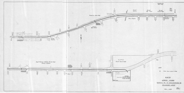
Drawing, Melbourne & Metropolitan Tramways Board (MMTB), "Burwood Highway Warragul Rd to Middleborough Rd - Preliminary Layout", c1975
... , and a track into a proposed shopping centre complex where a bus..., and a track into a proposed shopping centre complex where a bus ...Drawing, folded sheet to A4, titled "Burwood Highway Warragul Rd to Middleborough Rd - Preliminary Layout" showing the proposed layout of the tramway that was later built by the MMTB. Shows track alignment, cross streets, schools, the RSPCA, and a track into a proposed shopping centre complex where a bus interchange was noted. Part of a larger report.trams, tramways, burwood, burwood highway, new tramway, middleborough rd, buses -
 Melbourne Tram Museum
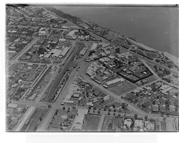
Photograph - Digital Image, Kevin O'Reilly, Sandringham" looking south over the Sandringham Railway station, mid 1920's
... , shopping centre, Tait train in the platform and the beach front..., Sandringham tram depot, shopping centre, Tait train in the platform ...Image from CD (Compact Diskette for use in computers) - see Reg Item 135. Image titled "Sandringham" on CD, of looking south over the Sandringham Railway station, shows the interlocked gates at the level crossing, Sandringham tram depot, shopping centre, Tait train in the platform and the beach front. Mid 1920's?trams, tramways, sandringham, vr trams -
 Greensborough Historical Society
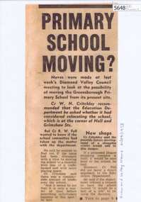
Newspaper Clipping, Primary school moving?, 21/08/1973
... shopping centre close to Greensborough Primary School led to some... occasioned by a new shopping centre close to Greensborough Primary ...Concern about increased traffic occasioned by a new shopping centre close to Greensborough Primary School led to some Councillors suggesting that the Education Department should be asked whether it was considering relocation of the school. [1973]Photocopy of newspaper clipping, black text, laminated.greensborough primary school, greensborough plaza -
 Robin Boyd Foundation
Document, Plan
... ) with home units, housing commission, shopping centre and public...) with home units, housing commission, shopping centre and public ...Plan of Eastlakes development NSW (north of Botany) with home units, housing commission, shopping centre and public reserve between Gardeners RD, Universal Street, Grafton Street, Florence Street and Maloney Street.Photocopy, double page taped on reverse. Handwritten and typewritten. -
 City of Kingston
Photograph - Black and white, c. 1965
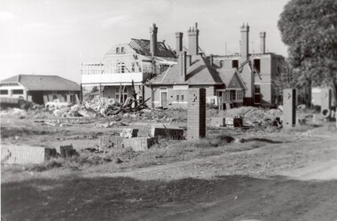
... and was later demolished to make way for Southland Shopping Centre. ... and was later demolished to make way for Southland Shopping Centre ...The St John of God Home for Disadvantaged Boys was located on Nepean Highway Chletenham, and was previously known as the Methodist Children's Home. It opened in approximately 1953 and was later demolished to make way for Southland Shopping Centre. The Brothers of St John of God were a Catholic order that first arrived in Australia in 1947, establishing their first school for boys with learning difficulties. They soon acquired 20 acres in Cheltenham in 1953, which became home to 100 boys and young men who could no longer live with their familiesBlack and white image of a demolition site where the St John of God Home for Disadvantaged Boys once stood. Buildings are visible behind the boys' home site, although also slated for demolition.Black printed text on white round sticker on reverse: 231 Handwritten in red ink on reverse: 95%religion, cheltenham, orphanage, boys home -
 Ballarat Tramway Museum
Negative, Wal Jack, mid to late 1940's
... hall - this area (2020) is now a car park and major shopping... and major shopping centre area. Photo mid to late 1940's ...Negative and Digital images of the Wal Jack Geelong Negative file of the Geelong 33 in bound to the City and then North at the intersection of Regent and High St Belmont. Tram is picking up passengers. In the background is a school or church hall - this area (2020) is now a car park and major shopping centre area. Photo mid to late 1940's. trams, tramways, geelong, high st, belmont, north, tram 33 -
 Ringwood and District Historical Society
Photograph, Outside the Ringwood Market in Maroondah Hwy. 1925
... in Maroondah Hwy. 1925. Shop in centre (is) at corner of Ringwood... the Ringwood Market in Maroondah Hwy. 1925. Shop in centre ...Black and white photograph of street scene showing unmade road with horses and carts at roadsides and wooden buildings to left of photograph. (2 copies)Typed below photograph, "Outside the Ringwood Market in Maroondah Hwy. 1925. Shop in centre (is) at corner of Ringwood Street. ... ". -
 Vision Australia
Photograph - Image, Richard Carbone and Mal Fraser, October 2007
... navigate the escalators at Maribyrnong shopping centre (Highpoint... navigate the escalators at Maribyrnong shopping centre (Highpoint ...Images taken of schoolboy Richard Carbone, who worked with Orientation and Mobility Instructor Malcolm Fraser to successfully navigate the escalators at Maribyrnong shopping centre (Highpoint?) One image reproduced in 2007-8 Annual Report.16 digital images of Richard Carbone and Mal Fraservision australia, richard carbone, malcolm fraser, orientation and mobility -
 City of Kingston
Photograph - Black and white, 20 December 1945
... of the Southland shopping centre in the 1960s and expansion in the 1990s.... of the Southland shopping centre in the 1960s and expansion in the 1990s ...This aerial photograph depicts the changing landscape of Cheltenham and Highett since WWII. Photographed in 1945, there is a mix of urban dwellings and industrial development and precedes the major transformation of Cheltenham with the development of the Southland shopping centre in the 1960s and expansion in the 1990s.A large part of Cheltenham was originally established as a rural market gardening community. The railway line and station brought urban development to the area and in the north, the Highett area was dominated by the Highett Gas Works. Cheltenham became a major destination for shopping in the 1960s with the opening of Southland.Aerial photograph taken in 1945 of Cheltenham and Highett within the City of Kingston. The image includes the Highett Reserve, (top right), the Methodist Children Homes (now Southland), Nepean Highway and Jamieson Street. Highett Gas Works is visible in the top left and the land now named William Fry Reserve at the intersection of Bay Road and Nepean Highway. A visible large parcel of land on the corner of Bay Road and Nepean Highway was developed in the 1990s as the west side addition to Southland. The densely vegetated area in the upper right sector of the image is now dense with housing. Tulip Grove, Heather Grove and Gilford Street are visible bottom left. This image is possibly from the collection of aerial photographs commissioned by the Department of Crown Lands and Survey and taken by Adastra Airways.Black ink: 57252 White lettering: VIC-10 57252 20.12.45 [lens information indecipherable] PROJ. No.5 MELB. METROP AREA Black pencil: 80highett, cheltenham, highett gas works, urbanisation -
 City of Kingston
Photograph - Black and white, 20 December 1945
... of the Southland shopping centre in the 1960s and expansion in the 1990s.... of the Southland shopping centre in the 1960s and expansion in the 1990s ...This aerial photograph depicts the changing landscape of Cheltenham and Highett since WWII. Photographed in 1945, there is a mix of urban dwellings and industrial development and precedes the major transformation of Cheltenham with the development of the Southland shopping centre in the 1960s and expansion in the 1990s.A large part of Cheltenham was originally established as a rural market gardening community. The railway line and station brought urban development to the area and in the north, the Highett area was dominated by the Highett Gas Works. Cheltenham became a major destination for shopping in the 1960s with the opening of Southland.Aerial photograph taken in 1945 of Cheltenham and Highett within the City of Kingston. The image includes the Highett Reserve, (top right), the Methodist Children Homes (now Southland), Nepean Highway and Jamieson Street. Highett Gas Works is visible in the top left and the land now named William Fry Reserve at the intersection of Bay Road and Nepean Highway. A visible large parcel of land on the corner of Bay Road and Nepean Highway was developed in the 1990s as the west side addition to Southland. The densely vegetated area in the upper right sector of the image is now dense with housing. Tulip Grove, Heather Grove and Gilford Street are visible bottom left. This image is possibly from the collection of aerial photographs commissioned by the Department of Crown Lands and Survey and taken by Adastra Airways.Black type: Reverse lettering VIC-10 57252 20.12.45 [lens information indecipherable] PROJ. No.5 MELB. METROP AREA White lettering: Reverse writing 57252cheltenham, highett, highett gas works, urbanisation -
 Ringwood and District Historical Society
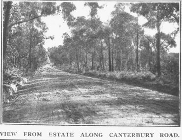
Photograph, Coleman's Heathmont Estate Sale, 15/12/1923. Looking west along Canterbury Road Heathmont. Railway bridge is situated at foot of hill
... . Area in foreground now shopping centre both sides of road."... bridge at foot of hill 1923. Area in foreground now shopping ...Printing below photograph reads, "View from estate along Canterbury Road." Typed on backing sheet below, "Canterbury Rd. Heathmont looking towards city. Railway bridge at foot of hill 1923. Area in foreground now shopping centre both sides of road." -
 Whitehorse Historical Society Inc.
Article, Gas attack finishes siege, 1996
... Hoey, at Wainwright Ryan's office in Mitcham Shopping Centre... Mitcham melbourne shops mitcham shopping centre wainwright ryan ...A twelve hour siege ended with police using Capsicum spray and tear gas to apprehend a gun man who held up a solicitor, John Hoey, at Wainwright Ryan's office in Mitcham Shopping Centre.A twelve hour siege ended with police using Capsicum spray and tear gas to apprehend a gun man who held up a solicitor, John Hoey, at Wainwright Ryan's office in Mitcham Shopping Centre. The Gun man, Peter Morris, was furious about losing a family court battle with his wife, which ordered he surrender a property.A twelve hour siege ended with police using Capsicum spray and tear gas to apprehend a gun man who held up a solicitor, John Hoey, at Wainwright Ryan's office in Mitcham Shopping Centre.shops, mitcham shopping centre, wainwright ryan solicitors, hoey, john, morris, peter evan john, graham, margaret -
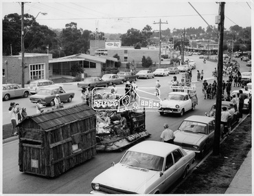 Eltham District Historical Society Inc
Photograph, Procession of Floats in Main Road Eltham, 10 Apr 1971
... The Procession of floats travelled from the Eltham Shopping... Shopping Centre to Eltham Lower Park on Saturday 10th April as part ...The Procession of floats travelled from the Eltham Shopping Centre to Eltham Lower Park on Saturday 10th April as part of the Shire of Eltham centenary celebrations program. The Infant Welfare Centre and BP service station can be seen in the background. This photo forms part of a collection of photographs gathered by the Shire of Eltham for their centenary project book," Pioneers and Painters: 100 years of the Shire of Eltham" by Alan Marshall (1971). The collection of over 500 images is held in partnership between Eltham District Historical Society and Yarra Plenty Regional Library (Eltham Library) and is now formally known as 'The Shire of Eltham Pioneers Photograph Collection.' It is significant in being the first community sourced collection representing the places and people of the Shire's first one hundred years.Digital imagesepp, shire of eltham pioneers photograph collection, shire of eltham, shire of eltham centenary, centenary celebrations, parade floats, parade, main road, eltham, infant welfare centre, bp service station -
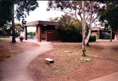 Hume City Civic Collection
Photograph, Late 1980's
... shopping centre in Sunbury.... shopping centre in Sunbury. vandalism public toilet blocks evans ...The series of seven photographs highlight examples of vandalism within the town centre precinct. Most of the vandalism occurred on public buildings. The toilet block was demolished in the late 1990's to make way for further expansion of the retail shopping centre in Sunbury.A coloured photograph of the Sunbury Comfort Station which was erected on a section of public land in Evans Street between the post office and Sunbury Shopping Square. The brown brick building has an open porch on one side and a curved concrete path leads from the street to the building. A smaller block is in the background and a grassed ared with trees is in the foreground with rubbish thrown across the grass.vandalism, public toilet blocks, evans street, sunbury comfort station, shire of bulla, george evans collection -
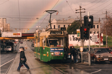 Melbourne Tram Museum
Photograph - Colour Print - Racecourse Road - Z3 203 with a rainbow
... shopping centre, stop in Racecourse Road. The tram is in The Met... Colour print of Z3 203 (Route 57) at the Newmarket Plaza shopping ...Colour print of Z3 203 (Route 57) at the Newmarket Plaza shopping centre, stop in Racecourse Road. The tram is in The Met/PTC colour scheme. In the background are the Douta Galla Hotel, the Newmarket Station railway overbridge and a rainbow. Photo c2000.Yields information about the use of the use of Z3 trams on route 57.Colour print - printed on Kodak Professional paper.trams, tramways, z3 class, tram 203, racecourse road, newmarket, route 57 -
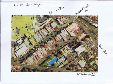 Greensborough Historical Society
Folder, Banyule City Council, Main Street Greensborough, 2007-2011
... Henry and Main Streets. Greensborough Shopping Centre prior.... Greensborough Shopping Centre prior to the construction of Watermarc ...Folder of coloured photographs of Main Street Greensborough, plus one aerial photograph of the area bounded by Grimshaw, Flintoff, Para and Main Streets and one of Grimshaw Street between Henry and Main Streets. Greensborough Shopping Centre prior to the construction of WatermarcGreen plastic folder of coloured photographic prints of Main Street Greensborough.main street greensborough, banyule city council, watermarc -
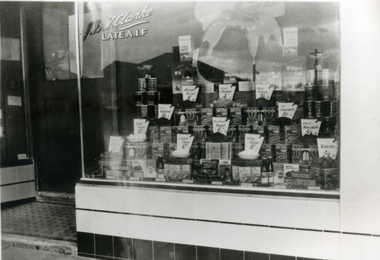 Whitehorse Historical Society Inc.
Photograph, Clarke's Grocer Shop
... in Rangeview Shopping Centre. Owned by J.B. Clarke and run by he, his... shop in Rangeview Shopping Centre. Owned by J.B. Clarke and run ...Black and white photo of Clarke's Grocer Shop in Mitcham Road, Mitcham. Double fronted shop. Second shop in Rangeview Shopping Centre. Owned by J.B. Clarke and run by he, his wife and his son , Fraser, for a long time. He was still advertising in 'Local Advertiser', Page 1, 1963. 'Late AIF' on window indicates after World War One.clarke, j.b. -
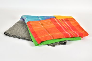 National Wool Museum
Textile - Wagga Blanket, May Shortte, 1940s
... Market Square Shopping Centre). May Shortte is the grandmother... (now Market Square Shopping Centre). May Shortte ...This wagga style blanket was made by May Shortte using blanket samples from Solomons department store, Geelong (now Market Square Shopping Centre). May Shortte is the grandmother of Emily McNeight. Part of a collection of three blankets donated by Emily McNeight.Blue, orange, green, yellow, purple and grey wagga style blanket made with off cuts of blankets.wool, blankets, wagga, solomons, geelong, may shortte, samples -
 Ringwood and District Historical Society
Newspaper, Scrapbook Clipping, Library Collection, Ringwood, Victoria, `
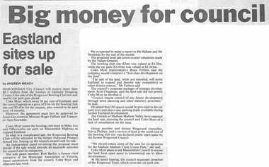
... from the trustees of Eastland Shopping Centre if the sale... Shopping Centre if the sale of the Ringwood Bowling Club and nearby ...``Newspaper clipping from The "Mail" , 24-10-95 P3. Big Money for Council. Eastland sites up for sale.By Andrew MeathMaroondah City Council will receiove more than $8.5 million from the trustees of Eastland Shopping Centre if the sale of the Ringwood Bowling Club and nearby car park goes ahead. However, the agreement must first be approved by Local Government Minister Roger Hallam and Treasurer Alan Stockdale.` -
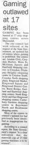 Ringwood and District Historical Society
Newspaper, Scrapbook Clipping, Library Collection, Ringwood, Victoria, `
... Gaming has been banned at 17 strip shopping centres across... at 17 strip shopping centres across Maroondah. Most ...``Newspaper clipping from "The Post", 17/2/98, P 11. Gaming outlawed at 17 sites Gaming has been banned at 17 strip shopping centres across Maroondah. Most of the centres of council's updated list had previously been identified as inappropriate for gaming. According to a council report, the State Government's request "is a clear indication that the statewide cap of 27,500 gaming machines is to be retained.` -
 Ringwood and District Historical Society
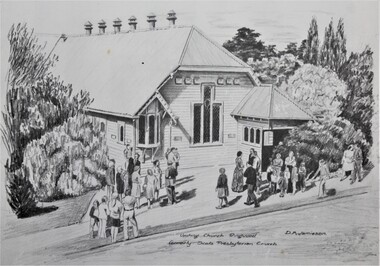
Work on paper - Pencil sketches, Two views of the Uniting Church Ringwood formerly Scots Presbyterian Church Ringwood c1960s
... for the development of Eastlands Shopping centre in the 1960s. The Pulpit... was knocked down to make way for the development of Eastlands Shopping ...The two etchings of Scots Presbyterian Church formerly in Adelaide Street Ringwood which was knocked down to make way for the development of Eastlands Shopping centre in the 1960s. The Pulpit and Window were moved to the Uniting Church in Station Street, Ringwood. The etchings were done by D.M. Jamieson .1.Copy of Hand drawn image of the Scots Presbyterian Church in Adelaide Street, Ringwood, Victoria, with congregation standing outside. 2. Copy of Hand drawn image of Church interior showing the pulpit, stain glass window, hymn board and seating for the Elders taken after the Church was knocked down and placed in the Uniting Church, Station Street, Ringwood. -
Glen Eira Historical Society
Document - Elsternwick
... in the area. Correspondence from Elsternwick Shopping Centre... in the area. Correspondence from Elsternwick Shopping Centre ...This file contains two items. A twenty seven page roneod document produced by Caulfield Council c.1970s, for a neighbourhood study on shop types, plazas and general attractiveness in the area. Correspondence from Elsternwick Shopping Centre Management re 1997 Elsternwick Festival of Fables.neighbourhood study, elsternwick, festival of fables, festivals, jones sara, danzig steve, glenhuntly road, elsternwick shopping centre -
 City of Kingston
Photograph - Black and white, 20 December 1945
... into housing and industrial estates. The Southland shopping centre... into housing and industrial estates. The Southland shopping centre ...Cheltenham is a suburb in the City of Kingston that was originally established as a rural market gardening community. The area is bordered by Highett, Mentone and Heatherton. The market gardens, farms and paddocks have gradually been sub-divided into housing and industrial estates. The Southland shopping centre is a major feature of the area.Cheltenham was established as a rural market gardening community. The Le Page family lived in Cheltenham since 1854 when Nicholas Le Page, a tailor from the Channel Island of Guernsey, bought two acres of land on Chesterville Road near Bernard Street to establish a market garden. Over the years the Le Pages purchased more land in the area. In 1875-76 Nicholas' son Frank and his wife Mary built 'Daphne Cottage' near the corner of Bernard and Wilson Streets. n the 1940s Frank's son, Everest Le Page, bought five more lots of land in Chesterville Road from the Tuck family. The Le Pages grazed horses, ponies and cows on this land, and grew pumpkins, carrots, parsnips, onions, potatoes and cabbages. Many buildings and locations within in Cheltenham commemorate the Le Page family's contribution to the Cheltenham community.Aerial photograph taken in 1945 of the Cheltenham district within the City of Kingston. The image includes Chesterville Road, the future site of Turner Road pool (now Waves) and Highett Reserve, (top left), Jellicoe Street, Argus Street, Bernard Street, Wilson Street, the Methodist Children Homes (now Southland), McIvor Street, Goulburn Street, Nepean Highway, Jamieson Street and Barker Street (bottom left), market gardens and paddocks. In the top centre of the image, "Daphne Cottage", the home of Frank T. Le Page is visible on the corner of Bernard and Wilson Streets. Much of the land depicted in this image was owned by the Le Page family. This image is possibly from the collection of aerial photographs commissioned by the Department of Crown Lands and Survey and taken by Adastra Airways.Black and white ink: 57250 White print: VIC-170 57250 20.12.45 Run 6 PROJ. No. 5 MELB. METROP AREA Black type 10200 FTS 30' LENS 20.12.45cheltenham, market gardens, industry, le page family -
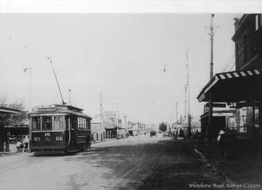 Ballarat Tramway Museum
Photograph - Black & White Photograph/s, c1920
... . In the background is the Balwyn shopping centre. The tram became Geelong... shopping centre. The tram became Geelong No. 25 and then Geelong 28 ...Yields information about MMTB No. 66 which later became Geelong No. 28.Black and white photograph - copy photograph from a postcard of MMTB or PMTT 66 outbound in Whitehorse Road Balwyn. Tram has the destination of Mont Albert, route 15. In the background is the Balwyn shopping centre. The tram became Geelong No. 25 and then Geelong 28 in 1951. See April 1981 issue of Trolley Wire. In the bottom right hand corner titled "Whitehorse Road, Balwyn C1920s"trams, tramways, whitehorse road, balwyn, pmtt, mmtb, j class, geelong, tram 66 -
 Melbourne Tram Museum
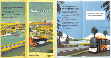
Map, Transport for Victoria, "Manningham Transport Map", c2018
... for the City of Manningham, cantered around the Doncaster Shopping... of Manningham, cantered around the Doncaster Shopping centre. Covers ...Pamphlet - 12 fold DL - colour titled "Manningham by Bus" or "Manningham Transport Map", giving a detailed bus and tram map for the City of Manningham, cantered around the Doncaster Shopping centre. Covers route 109 and 48. Published by "Transport for Victoria" c2018 - no publication date. The tram portion of the map has been imaged. At the time of entry, the given website "melbournebybus.com.au" went to the PTV website.trams, tramways, maps, manningham, route 48, route 109 -
 Hume City Civic Collection
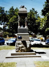
Photograph, Starkie fountain
... was at the intersection of O'Shanassy and Brook Streets. As the shopping centre... was at the intersection of O'Shanassy and Brook Streets. As the shopping centre ...The Starkie drinking fountain was erected to commemorate the work done by Joseph Starkie to formation of the Sunbury Waterworks Trust in 1905. This later led to the establishment of a water supply system in Sunbury. Originally the fountain was at the intersection of O'Shanassy and Brook Streets. As the shopping centre expanded, the fountain was moved to a reserve in the Village Green. The establishment of a town water supply system in Sunbury in the early years of the nineteenth century was quite an achievement.A coloured photograph of a drinking fountain set in a grassed area. Parked cars can be seen in the background.sunbury waterworks trust, joseph starkie -
Whitehorse Historical Society Inc.
Article, Seige 'shuts down' Mitcham, 1996
... on Maroondah Highway, Mitcham Shopping Centre, with a gun and took John... Mitcham melbourne shops mitcham shopping centre hoey john morris ...A man entered Wainwright Ryan, barristers and Solicitors on Maroondah Highway, Mitcham Shopping Centre, with a gun and took John Hoey hostage.A man entered Wainwright Ryan, barristers and Solicitors on Maroondah Highway, Mitcham Shopping Centre, with a gun and took John Hoey hostage. Six women working upstairs barricaded themselves in a back room. The man held off police for 12 hours. police finally overcame the man with capsicum spray after luring him out to the balcony. Peter Morris appeared in Ringwood court under several charges.A man entered Wainwright Ryan, barristers and Solicitors on Maroondah Highway, Mitcham Shopping Centre, with a gun and took John Hoey hostage. shops, mitcham shopping centre, hoey, john, morris, peter evan john, wainwright ryan, solicitors -
 Whitehorse Historical Society Inc.
Photograph, Our Lady of Fatima Parade, C.1950's
... through Mitcham Shopping Centre, Whitehorse Road, Mitcham, on its... of Our Lady of Fatima Parade passing through Mitcham Shopping ...Black and white photo of Our Lady of Fatima Parade passing through Mitcham Shopping Centre, Whitehorse Road, Mitcham, on its way to Whitefriars Monastery, Park Road, Park Orchards C.1950's.H.S. Beckwith Authorised Newsagent (located at far right of photo) is number 503 Whitehorse Road, Mitcham. Note Mitcham Primary School (Junior School) at rear of Whitehorse Road shops.our lady of fatima parade -
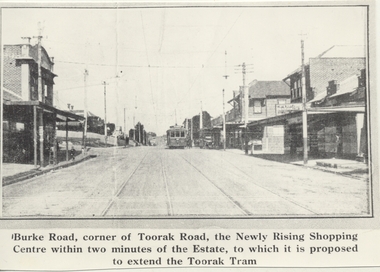 Melbourne Tram Museum
Photograph - Black & White Photograph/s, 1970's
... , the Newly Rising Shopping Centre within two minutes of the Estate... "Burke Road, corner of Toorak Road, the Newly Rising Shopping ...Black and white copy photograph from a Real Estate Poster of a tram in Burke Road, Camberwell, at corner of Toorak Road. Has title on photograph "Burke Road, corner of Toorak Road, the Newly Rising Shopping Centre within two minutes of the Estate, to which it is proposed to extend the Toorak Tram" Street lighting suspended off the tramway overhead. Tram is a single trucker in the PMTT numbering livery.trams, tramways, mmtb, pmtt, burke rd, toorak rd -
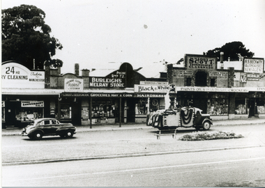
 Melbourne Tram Museum
Magazine, Glen Eira Historical Society, "Glen Eira Historical Society Newsletter", Sep. 2014
... " for September 2014 with items on the McKinnon Road shopping centre... with items on the McKinnon Road shopping centre, a report on a talk ...Parts OF the Glen Eira Historical Society Newsletter" for September 2014 with items on the McKinnon Road shopping centre, a report on a talk by Ian Jenkin of the ARHS Vic Div about the Caulfield horse tramway and the PMTT and a report of a walk along the horse tram route conducted by Peter Carwardine of the ARHS in July 2014. Includes a donation note from Member Keith Stodden, dated 25-9-2014trams, tramways, caulfield, horse trams, glen eira, mckinnon rd