Showing 1235 items matching "the gap"
-
 Kiewa Valley Historical Society
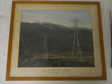
Framed photo - Mt Beauty Township & Main Transmission Line, 1954
This is a photo of Mount Beauty taken from a high vantage point near the hair-pin bend on the Tawonga Gap Road (half way up) in 1954. Mount Beauty was built by the State Electricity Commission of Victoria during the construction of the Kiewa Hydro Electric Scheme.This photo belonged to Mr & Mrs Gordon White SECV employee and long time residents of Mt Beauty.This is a framed coloured photo of the Mount Beauty Township and main Transmission Line from Mt Beauty to Kiewa. The photo has two transmission lines in the foreground with the Mt Beauty township in the background, but at the foot of Mount Bogong.Approx 1954 / Conroy-Moffatt Pty Ltd / Picture Framer / ..McKillop Street / Tel Mu .. 78 ....mt beauty; transmission line; tawonga gap road; kiewa hydro electric scheme -
 Halls Gap & Grampians Historical Society
Photograph - B/W
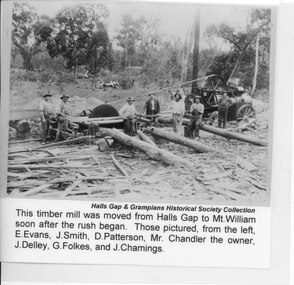
This timber mill was moved from Halls Gap to Mt William soon after the rush began. Those pictured (from left to right) are: E Evans, J Smith, D Patterson, Mr Chandler (the owner), J Delley, G Folkes and J Chamings.The photo shows seven men grouped around a large saw, which is driven by a traction engine. There arethree large logs and wood scraps in the foreground and a pile of sawdust can be seen behind the saw.timber industries, logging, sawmilling -
 Halls Gap & Grampians Historical Society
Photograph - B/W, C 1952
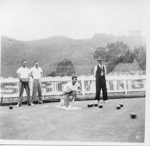
Halls Gap once boasted a fine Bowling Green, ideally situated next door to the Kookaburra Cafe. These days lawn bowling has been replaced by another bowling game, Petanque, with regular meets taking place at the club's "piste" beside the recreation centre.Three men dressed in casual clothes, two men in slacks and white shirts,another man standing to the side is dressed in dark pants and vest with a hat on. One man is kneeling after bowling. A number of bowls are on the green, behind the men is a white picket fence. The Mt.William Range is in the background.On reverse M.Mair about 1952recreation, lawn bowling -
 Sunbury Family History and Heritage Society Inc.
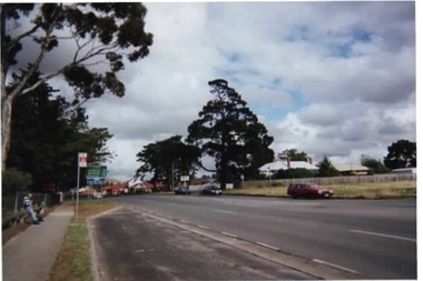
Photograph, Rosa McCall, Gap Road, Sunbury, 2000
The photograph is of Gap Road just west of Horne Street in Sunbury. The open ground on the RHS is on the corner of Pasley Street and was taken before the adjoining blue stone cottage was demolished. In 2020 the cottage was demolished and a large medical centre, complete with car parking was built on the property.Gap Road is one of Sunbury's main roads and is the quickset route to take from the town to the Calder Highway and on to Bendigo.A coloured photograph of a main road with a bus stop in the foreground and some open ground on the RHS of the image. gap road, pasley street, medical centre, sunbury -
 Kiewa Valley Historical Society
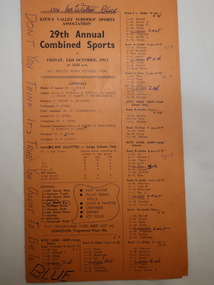
Programme - 29th Annual Combined Sports 1971, Kiewa Valley Schools' Sports Association
Combined school athletic sports were held annually. This one was between 11 teams: Mt. Beauty Black, Tawonga Purple, Mt Beauty Gold, Dederang, Mt Beauty Blue, Tawonga South, Mt Beauty Green, Bogong, Kancoona and Kergunyah South. Events included High Jump, Long Jump for Boys and Girls and Triple Jump for Boys. Also, Potato Race, Zig Zag team of 6, and Bounce Ball. Flat Races boys and girls. Championship for Boys and Girls Under and Over 10 years.Relay Team Open, Skip Ball Open. Tunnel Ball Open,.Circle Gap Open and a Boys and Girls Circle Gap 220 yards.Primary Schools from the Kiewa Valley held athletic sports each year. The schools consisted of small and big schools in the Kiewa Valley. The events included running and jumping as well as team 'fun/novelty' events.Events were run according to age and differed between boys and girls.Orange cardboard athletic sports programme folded in half with 69 events listed with "Officials" named and children's names or teams listed. "Don't you Think It's True You Ought To Be in Blue" penned on the front. "Good Old Blue. Blue Forever. We stick to First Place." "Blue is the Best" "No Sweat to Blue" penned on the fold in the middle. "Good Old Blue" and "Blue" penned on the back.athletics., athletics sports day, school sports, kiewa valley sports -
 Mt Dandenong & District Historical Society Inc.
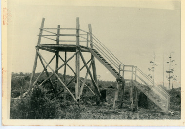
Photograph, Lookout On Top of Mount Olinda 1910, c1910
c1910 Lookout tower on the hill behind tthe school at Olinda.This shows the first one built. It was followed by a covered lookout. This position lost its value when the trees grew high. The descriptive text on the reverse of this photograph was hand written by John Lundy-Clarke.The lookout on the top of Mt Olinda 1910. This one was the first one it was followed by a covered one but the position lost its value with the growth of trees in the area. It is looking towards what is now Kalorama and the Jeeves clearing in the gap can be seen at the extreme left. lookout, tower, mt olinda, mount olinda -
 Mt Dandenong & District Historical Society Inc.
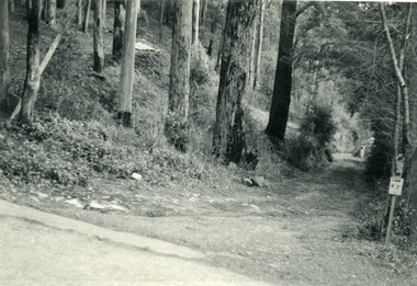
Photograph, The Wagon Road, c1970s
The old Wagon Road built 1876-1878. This photograph has a detailed inscription on the back handwritten by John Lundy-Clarke in 1974.The Wagon Road. Built 1876 – 8. The first settler’s road in the Ranges as apart from Dray Tracks. Was built through Jeeves Selection, Crown Allotment “C” named “Jeeves saddle” and removed the monopoly held over travel through the Gap. jeeves saddle, kalorama, road, wagon road, john lundy-clarke -
 Halls Gap & Grampians Historical Society
Newspaper - B/W, 29/12/2000
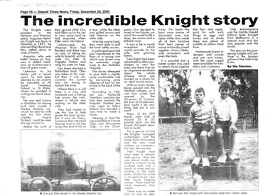
This is a newspaper article about the Knight family. It was written by Ida Stanton for the Stawell Times-News "Halls Gap Extra" and was published on Friday, 29 December 2000, p.16. The photos included in the article are C 1881. For more information see "Victoria's Wonderland", "Water between the hills".A newspaper article headed "The Incredible Knight story", containing two photos. The photos are of a couple (Gus and Ellen Knight) in a Stanley Steamer car; and two boys (Bert and Ken Knight) sitting on a pile of boxes with a small dog in the foreground. They are wearing shoes made from rubber tubes.people, knight -
 Whitehorse Historical Society Inc.
Functional object - Letter Opener
From the Betty McPhee writing equipment collectionA bone coloured letter called a 'letter scale' with an embossed imperial scale to 7 inches on one edge. Handle has five red dots marking 1/4 oz, 1/2 oz, 1oz, 1 1/2 oz & 2oz. On reverse is inscription 'insert letter' to mark gap to weigh letter and an additional inscription 'grasp rotary button and balance'. Embossed in blue with compliments ALLEN & HANBURYSWith compliments ALLEN & HANBURYScommerce, office equipment / stationery, domestic items, writing equipment -
 Stawell Historical Society Inc
Photograph, Stawell Times News, Stawell Boomerang Club, 23/4/1965
Copy of photo from Stawell Times News. B/W 16 students in background watching Ralph Sinclair in foreground about to catch his returning Boomerang. Students: Denis White, Graham Cahill, Ron Kewish, Chris Peters?, Ronald Mudra?, Donald Hutchinson?,Ron Watman (Halls Gap), Donald Hutchins?, Geoff Bonney?, Shane Friend, Dot McGonical (Teacher?), Chris Hateley, Owen Martin?. -
 Halls Gap & Grampians Historical Society
Map - Coloured
Background on Bridle Path up Stony Creek Gorge Pre 1840 C. B. Hall, squatter on Mokepilly Run 1841-1842, first European to discover the Fyans Creek valley, the entrance of which became known as Hall's Gap. He later recorded that he followed a number of tracks which he assumed had been made by the Aboriginies and described one as "leading up a wild romantic glen and over on to the source of the Glenelg River". This could well have been the route taken up Stony Creek gorge by the first timber-cutters in this part of the Grampians to the saddle between the Wonderland and Mt. Difficult ranges known as Valley Gap 1850s/60s Timber cutters and shingle splitters were reported to be moving into the eastern side of the Grampians and by the mid 1860s there were a number of families connected to the supplying of timber to Pleasant Creek living in the "Hall's Gap ranges". John Wakeham, the first store owner in Pleasant Creek in 1854, established a timer-mill in upper Stony Creek Gorge in the late 1850s. Wakeham is credited for the clearing and levelling of the first bridle-path up the gorge. 1870s By the mid 1870s the track had been extended over Valley Gap to the Victoria Forest (the upper region of the Victoria Valley). McKeon's bullock team was known to have hauled red gum from the Valley to Stawell in the late 1870s and the 1880s. 1880s In 1887 an article in the Pleasant Creek news describes the Stony Creek Gorge track as "being a ledge alongside the mountain range, formed in the early days with the aid of earth and timber, along which the bullock teams used to travel to Horsham and plains of the Wimmera beyond." 1890s Gold was discovered in the catchment area of Stony Creek and by the end of the 1890s a new track was built from "near the junction of Fyan's and Stony Creeks, up the gorge to the diggings settlement. The mining Department had paid L300 for its construction and, when completed, the track was "three miles and 30 chains in length, the side cuttings at the narrowest part being 10 feet between" and "the watercourses which cross the track at various points" having been "filled up with rocks rolled down the sides of the hills, and consequently there can be no damage caused by bushfires which destroyed the former wooden bridges erected on the old track to Wakeham's saw-mill, the remains of which are still to be seen at the side of the diggings" The article goes on to further describe the track as one which "can with ease travel with a two horse conveyance either up or down" and that the workmen engaged in the construction of the track would be attending "a ball that night at McKeon's farm near the mouth of the gap to celebrate the successful completion of the undertaking". 1900s At what time the bridle path was extended beyond Valley Gap to the Wartook basin on the Mt. Difficult Range has not yet been determined. However, it is known that, by the turn of the century, people were travelling between Halls Gap and the caretakers' residence at Wartook Reservoir along what was now known as the "Bluff Road. Wartook's embankment had been constructed in 1887 and at that time there was already a track from Rosebrook Station homestead (near the present day Wartook Pottery) to the reservoir. Philip Rose owned both Rosebrook and Wartook Stations from the mid 1840s to the late 1850s and had regularly leased the Wartook basin to Cobb & Co. to rest horses there. 1920s Following the war of 1914-1918, tourism really took off in the Grampians, and Halls Gap rapidly grew. People would travel as far as they could on the many tracks then hike to the many lookouts being discovered by local tour guides. This led to the need for access across the range so that horse riders and the increasing number of vehicles could travel between Horsham and Halls Gap. To this end, the Bluff Road was improved and extended on 1929 and at its opening in March, 1930, by Lady Somers it was renamed the Mt. Victory Road.Map of Mt Victory Road and othersaccess routes, mt victory rd, bridle path, roads -
 Halls Gap & Grampians Historical Society
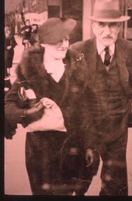
Photograph - Transparency, 1920-1930s
Thomas Morgan and his daughter Nina(Mangel). The Morgan Family purchased Killarney/Grampian House in 1927. Thomas,his wife Sylvia and four children- John,Thomas,Dorothy and Nina ran Grampian House. It was the first guest house in Halls Gap to offer hot and cold running water.A street photographer's photo showing a lady dressed in a fur stole and a suit, she is also wearing a hat, and a man dressed in a three piece suit wearing a hatpeople, morgan -
 Ballarat Heritage Services
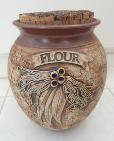
Ceramic - Ceramics, Ceramic Canister by Wartook Pottery, c1990
Graham WOOD Wartook Pottery was set up in the early 70s by Graham Wood, and was sucessful for nearly 25 years. It then moved to Halls Gap (The Grampians, Victoria), and the name was changed to Jimmy's Creek Pottery in 1998. The pottery conitnued under that name until 2003. when cheap imports hurt the business. Hand thrown ceramic canister with 'Gum Leaf' design. According to decorator Wendy McGuiness all decoration was made and applied by hand - an extremely time consuming activity. Texture to the body of each piece was created by using a piece of coral. Tenmoku glaze was applied to the top of the pieces, with iron oxide to the main body. This was the first of the Wartook range that sold commercially from around 1987 all over Australia. At the height of production Wartook Pottery had 5 employees, including a new wheel potter (who was adept at creating the pieces as Graham had done before). Additional ranges were still hand thrown, but with a floral wreath (slip cast) applied to the top of each pot, as well as a range that used decals for decoration. australian landscape pottery, les macleman, ceramics, landscape, graham wood -
 Sunbury Family History and Heritage Society Inc.
Photograph
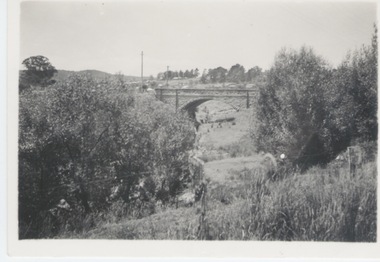
The single span bluestone bridge is on the Calder Highway at the base of Corkscrew Hill between Gap Road and the town of Gisborne. In the early 1990s the highway was widened and dual carriageways constructed, as a result the traffic no longer travelled along the winding Corkscrew Hill road. The bridge still stands between the two carriageways. A black and white photograph with a cream border of a single arched stone bridge spanning a watercourse. Small bushes are growing in the foreground and there are some buildings dotted across the hill in the middle distance.bridges, corkscrew hill, calder highway -
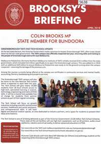 Greensborough Historical Society
Leaflet, Brooksy's briefing April 2018, 2018_04
Colin Brooks MP, the State Member of Parliament for the Bundoora district, publishes this monthly update on local matters for distribution in his electorate. This collection commences April 2018 and is ongoing. The GHS collection has a gap during 'Covid' years (2020-21) and recommences in February 2022, renumbered as Edition 1. Local history focusing on developments in the Bundoora electorate funded by the State government.One page, printed both sides in red and black, colour photosgreensborough, watsonia, macleod, bundoora, colin brooks -
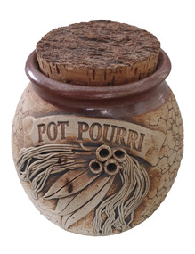 Ballarat Heritage Services
Ceramic - Ceramics, Ceramic Pot Pouri Canister by Wartook Pottery, c1990
Graham WOOD Wartook Pottery was set up in the early 70s by Graham Wood, and was sucessful for nearly 25 years. It then moved to Halls Gap (The Grampians, Victoria), and the name was changed to Jimmy's Creek Pottery in 1998. The pottery conitnued under that name until 2003. when cheap imports hurt the business. Hand thrown ceramic bowl with 'Gum Leaf' design and the words 'pot pouri'. According to decorator Wendy McGuiness all decoration was made and applied by hand - an extremely time consuming activity. Texture to the body of each piece was created by using a piece of coral. Tenmoku glaze was applied to the top of the pieces, with iron oxide to the main body. This was the first of the Wartook range that sold commercially from around 1987 all over Australia. At the height of production Wartook Pottery had 5 employees, including a new wheel potter (who was adept at creating the pieces as Graham had done before). Additional ranges were still hand thrown, but with a floral wreath (slip cast) applied to the top of each pot, as well as a range that used decals for decoration. australian landscape pottery, les macleman, ceramics, landscape, graham wood -
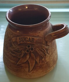 Ballarat Heritage Services
Ceramic - Ceramics, Ceramic Sugar bowl by Wartook Pottery, c1990
Graham WOOD Wartook Pottery was set up in the early 70s by Graham Wood, and was sucessful for nearly 25 years. It then moved to Halls Gap (The Grampians, Victoria), and the name was changed to Jimmy's Creek Pottery in 1998. The pottery conitnued under that name until 2003. when cheap imports hurt the business. Hand thrown ceramic bowl with 'Gum Leaf' design and the word 'sugar'. According to decorator Wendy McGuiness all decoration was made and applied by hand - an extremely time consuming activity. Texture to the body of each piece was created by using a piece of coral. Tenmoku glaze was applied to the top of the pieces, with iron oxide to the main body. This was the first of the Wartook range that sold commercially from around 1987 all over Australia. At the height of production Wartook Pottery had 5 employees, including a new wheel potter (who was adept at creating the pieces as Graham had done before). Additional ranges were still hand thrown, but with a floral wreath (slip cast) applied to the top of each pot, as well as a range that used decals for decoration. australian landscape pottery, les macleman, ceramics, landscape, graham wood -
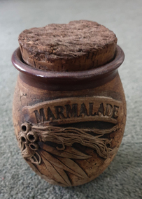 Ballarat Heritage Services
Ceramic - Ceramics, Ceramic Marmelade Canister by Wartook Pottery, c1990
Graham WOOD Wartook Pottery was set up in the early 70s by Graham Wood, and was sucessful for nearly 25 years. It then moved to Halls Gap (The Grampians, Victoria), and the name was changed to Jimmy's Creek Pottery in 1998. The pottery conitnued under that name until 2003. when cheap imports hurt the business. Hand thrown ceramic bowl with 'Gum Leaf' design and the words 'pot pouri'. According to decorator Wendy McGuiness all decoration was made and applied by hand - an extremely time consuming activity. Texture to the body of each piece was created by using a piece of coral. Tenmoku glaze was applied to the top of the pieces, with iron oxide to the main body. This was the first of the Wartook range that sold commercially from around 1987 all over Australia. At the height of production Wartook Pottery had 5 employees, including a new wheel potter (who was adept at creating the pieces as Graham had done before). Additional ranges were still hand thrown, but with a floral wreath (slip cast) applied to the top of each pot, as well as a range that used decals for decoration. australian landscape pottery, les macleman, ceramics, landscape, graham wood -
 Ballarat Heritage Services
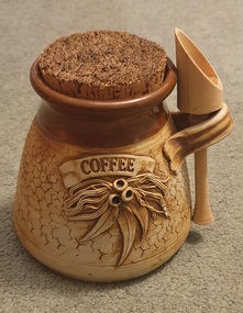
Ceramic - Ceramics, Ceramic Coffee Canister by Wartook Pottery, c1990
Graham WOOD Wartook Pottery was set up in the early 70s by Graham Wood, and was sucessful for nearly 25 years. It then moved to Halls Gap (The Grampians, Victoria), and the name was changed to Jimmy's Creek Pottery in 1998. The pottery conitnued under that name until 2003. when cheap imports hurt the business. Hand thrown ceramic bowl with 'Gum Leaf' design and the words 'coffee'. According to decorator Wendy McGuiness all decoration was made and applied by hand - an extremely time consuming activity. Texture to the body of each piece was created by using a piece of coral. Tenmoku glaze was applied to the top of the pieces, with iron oxide to the main body. This was the first of the Wartook range that sold commercially from around 1987 all over Australia. At the height of production Wartook Pottery had 5 employees, including a new wheel potter (who was adept at creating the pieces as Graham had done before). Additional ranges were still hand thrown, but with a floral wreath (slip cast) applied to the top of each pot, as well as a range that used decals for decoration. australian landscape pottery, les macleman, ceramics, landscape, graham wood -
 Kiewa Valley Historical Society
Newspaper Article - Thomas Briggs, 5th March 1988
Thomas Briggs was a pioneer of the Tawonga District. He worked on his parent's farm, selling goods, droving pigs and travelling to Yackandandah and Bright. He worked with pick and shovel on the Tawonga to Bright Road in 1902. He took up 320 acres of wild forest in Tawonga at 10 cents per acre per year for 20 years. He built a slab and shingle hut and a boundary fence. In 1886 he married Annie Maria Platt parenting 5 sons and 2 daughters until Annie died in 1953, aged 86 years.Thomas Briggs was a pioneer living in the Kiewa Valley with his parents and then with wife and family. This article is a history of his life from 1862 until 1887. See KVHS 0850 for information on the dray used to make the Tawonga Gap road - owned by John Briggs.Newspaper article Page 34 Border Morning Mail, Saturday, March 5, 1988 - Thomas Briggs Born 3rd Nov. 1862 who lived with his family at Upper Gundowring. His travels in the area including the Tawonga Gap and its construction in 1902 and his taking up of land in Tawonga in 1880. The article finishes in 1887 when he married Annie Maria Platt. The Thos Briggs story continues next week.thomas briggs; tawonga; kiewa valley; annie platt -
 Bendigo Historical Society Inc.
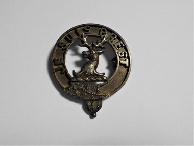
Accessory - BADGE COLLECTION: JE SUIS PREST BROOCH, UK
Object. Copper coloured ring shaped badge, 3D head and shoulders of a horned stag attached atop and bottom of rim across the centre gap. Around the top edge''JE SUIS PREST''(Translated ''I AM READY''). U shaped extension on lower edge of ring. Hinge and bracket from brooch clip on the back. He suis prest with a stag's head is the crest of Clan Fraser of Lovat - a Highland Scottish Clan.On back ''MEDLOCK INV''numismatics, badges-civil, je suis prest brooch badge -
 Anglesea and District Historical Society
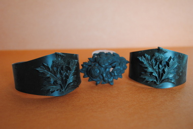
Mourning jewellery, Estimated 1850
Three pieces of Black Jet Mourning Jewellery - one small and one larger bracelet and one brooch. 1. Small bracelet narrower and overlapping at back, with ornately carved thistle centrefront in same black jet material. 2. Larger bracelet with gap at centre back, same ornate thistle on front as on smaller piece. 3. Carved black jet brooch, oval in shape depicting spray of flowers with metal clasp on back.bangle, brooch, black jet, lignite, mourning jewellery -
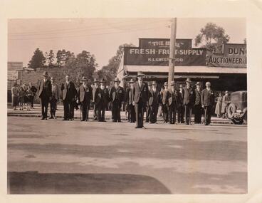 Southern Sherbrooke Historical Society Inc.
Photograph, Group of returned servicemen in Belgrave's main street, c. 1930s
Black and white photo showing a group of approximately 20+ returned soldiers wearing civilians clothing and standing at attention on the roadway of Belgrave's main street. Groups of civilians are watching them from the footpath. Shops on the low side of the street are visible behind them. '”The Ideal”/ Fresh Fruit Supply/K. L. Greenwood' and 'Dun../Auctioneer & …' also visible. There is a gap to the left of the fruiterer's shop, and Heathermont guest house is visible at the top of the hill in the background. -
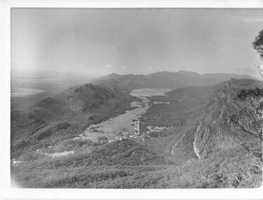 Halls Gap & Grampians Historical Society
Photograph - B/W
Photo has been taken from Boroka Peak/lookout, of the Fyans Valley and the township of Halls Gap. The Grampians/Dunkeld Road can be seen running North/South along the right edge of the valley and Lake Bellfield is the water at the end of the valley. Photo is typical of those taken by Forrests Commission at the timea photo of a valley, mostly cleared, flanked by two mountain ranges. A large body of water can be seen at the far end of the valley (middle of photo). Buildings and roads visible in the valley. Plains can be seen beyond the far mountain range on the left side of the scene.no.42scenery, fyans valley -
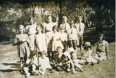 Stawell Historical Society Inc
Photograph, Deep Lead School Picnic at Halls Gap 1939
Deep Lead School Picnic 1939 at Halls Gap L to R: Pat Willis, Miss Afflick Head Teacher, ??, Brian McFeat Middle Row: Phyllis Repper, Rhonda McFeat, ?? , Doug McFeat Front Row: George Richards, Eunice Martin, Mick Martin, Frank Cray, Bill Grey, ???B/W Photo of a Group of 15 Children and Teacher outside.Names on Reverse Deep Lead School Picnic 1939deep lead school -
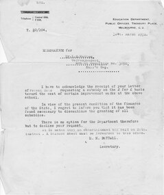 Halls Gap & Grampians Historical Society
Letter - Correspondence, 31/03/1931
Memo sent to school committee declining a subsidy on a pound for pound basis, for improvement works at the Halls Gap school. The reason given being that it had been necessary to discontinue the granting of all subsidies due to the condition of the finances of the State. The letter also requests a balance sheet for an entertainment held on 20 March 1931.Memo to Mr. L.S. Watten School Committee No. 3058 from M.H. Bottoms, Secretary of education Dept, Public Offices, Treasury Place, Melbourne.education, schools, halls gap -
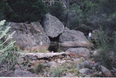 Halls Gap & Grampians Historical Society
Photograph - Coloured, 24/04/2005
The photo shows a small weir on the Stoney Creek which used to supply water to a number of early businesses in Halls Gap, such as the general store and Grampians House. Each business ran a pipe from the weir to their premises and three outlets can still be seen embedded in the wall. Record 248 was taken at the same time.Photograph of a woman approaching a small weir with three large boulders behind it. The original level of the weir can be seen on the boulders. The additional image is a description of how to get to the weir.scenery, stoney creek -
 Whitehorse Historical Society Inc.
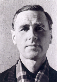
Photograph, Lionel Jones, c1944
Lionel was captured and became a prisoner of war in Italy. When Italy withdrew from the war they opened the gates of the P.O.W. camps. Lionel and a friend were working for Padroni who helped them with food and civilian clothing. They walked to the Switzerland border and with the help of Partisan who got them to Smugglers gap in the alps and then to Switzerland.Black & white photo of Lionel Jones in civvies after his escape as a P.O.W. See also ND4877 and Historyjones lionel, prisoners of war, world war 1939- 1945 -
 Kew Historical Society Inc
Plan - Subdivision Plan, J R Mathers & McMillan, Heart of Richmond Estate : Richmond, 1928
"In 1928 the land on the east side of Johnson Street was subdivided in 60 lots for the ‘Heart of Richmond Estate’. The houses in the subdivision, along the east side of Johnson Street, and in the newly created Hollick, Cole and Kennedy streets were constructed from 1928 to 1937." (Source: City of Yarra Heritage Gaps Review One 2013)Portion of subdivision plan pasted on to cardboard. Area includes Johnson Street, Victoria Street, Kennedy Street, Cole Street, Hollick Street, Bennett StreetTitle Certificate Vol.2381, Folio 476130 Phillips, Fox & Masel, 440 Little Collins Street, Melbourne (Local estate agent: Jas. R. Mathers & McMIllan, 136 Cotham Road, Kew)subdivision plans - richmond (vic.), heart of richmond estate -
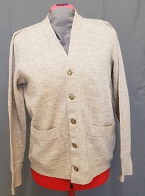 Bendigo Historical Society Inc.
Clothing - FAY BRYANT COLLECTION: HANRO MEN’S CARDIGAN, 1970s
Pure wool, fawn in colour, men’s cardigan. Five button, V neck front. One pocket on either side of front. Front band is 3.5cms wide and lined with cotton fabric, from the V opening to the hem to support buttons and button holes. Overlocked seams. A fine rib pattern, one cm wide is separated by a narrow one stitch gap. A finer rib, two stitches wide forms the cuffs, and lower band. Set-in sleeves.QUALITY KNITWEAR BY HANRO PURE WOOL 38costume, male, cardigan