Showing 601 items matching "victoria. department of planning "
-
 St Kilda Historical Society
Photograph - Photo map, 14/12/1963
One of a series of photo-maps produced for the Department of Crown Lands and Survey (1857-1983). For correlation with a current map, and access to other historical photo maps of Victoria, see the Historic Photo-Maps Index published by the Department of Environment, Land, Water and Planning at https://services.land.vic.gov.au/DELWPmaps/historical-photomaps/Black and white aerial photographVic 1807 Melbourne 1963 Project Run 16 14.12.1963 Lens 205 152.70 M/M 5.150 177st kilda, st kilda pier, catani gardens, middle park, albert park, st kilda west, st kilda beach, 1963 -
 St Kilda Historical Society
Photograph - Photo map, Department of Crown Lands and Survey, 22/01/1970
One of a series of photo-maps produced for the Department of Crown Lands and Survey (1857-1983). For correlation with a current map, and access to other historical photo maps of Victoria, see the Historic Photo-Maps Index published by the Department of Environment, Land, Water and Planning at https://services.land.vic.gov.au/DELWPmaps/historical-photomaps/Black and white aerial photographVic 2358 Department of Crown Lands and Survey Victoria,.© Melbourne 1970 Project Run 41E 22.1.70 5,100 ASL 64st kilda, st kilda cemetery, balaclava, st kilda east, windsor, caulfield north, alma park, 1970 -
 St Kilda Historical Society
Photograph - Photo map, Department of Crown Lands and Survey, 08/01/1970
One of a series of photo-maps produced for the Department of Crown Lands and Survey (1857-1983). For correlation with a current map, and access to other historical photo maps of Victoria, see the Historic Photo-Maps Index published by the Department of Environment, Land, Water and Planning at https://services.land.vic.gov.au/DELWPmaps/historical-photomaps/Black and white arial photographVic 2345 Department of Crown Lands and Survey Victoria,.© Melbourne 1970 Project Run 40 8.1.70 5,100 ASL 77albert park, fawkner park, south yarra, middle park, prahran, windsor, st kilda, st kilda west, 1970 -
 St Kilda Historical Society
Photograph - Photo map, 22/01/1970
One of a series of photo-maps produced for the Department of Crown Lands and Survey (1857-1983). For correlation with a current map, and access to other historical photo maps of Victoria, see the Historic Photo-Maps Index published by the Department of Environment, Land, Water and Planning at https://services.land.vic.gov.au/DELWPmaps/historical-photomaps/Black and white aerial photographVic 2358 Department of Crown Lands and Survey Victoria,.© Melbourne 1970 Project Run 43E 22.1.70 5,100 ASL 206elwood, elsternwick, elsternwick park, 1970 -
 Tatura Irrigation & Wartime Camps Museum
Book, Department of Agriculture Victoria, Institute for Sustainable Agriculture, 1993
Investigation of salinity problems by staff at Tatura, Kyabram, Shepparton, and Cobram Institutes.Department of Agriculture photos on front. Saline waterlogged land near Shepparton. Measuring white clover growth. Salinity management plans for research. Farm planning blueprint. Satellite image of plains and Lodden river.salinity, department of agriculture, kyabram, tatura, shepparton, cobram -
University of Melbourne, Burnley Campus Archives
Article - Photocopy, Horticultural Society of Victoria, 1860
Photocopy of Newspaper Article, Thursday 2 August, 1860 p 7 Report of the monthly meeting of the HSV Municipal Council of Richmond and commissioner of Public Works had granted funds for fencing the gardens and plans for a special meeting as soon as the Department of Lands had granted them land in the Surrey Paddock.Newspaper article from The Argusthe argus, surrey paddock, burnley gardens, horticultural society of victoria, hsv -
 University of Melbourne, Burnley Campus Archives
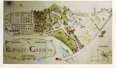
Slide - Colour slide, Milton Gellert, Department of Agriculture Burnley Gardens Victoria, 1955-1990
Copied for use as a postcard for the Centennial Year in 1990. Note by T.H. Kneen 18 March 1992, "The original drawing was done by Milton Gellert and for a considerable time was displayed in the Fruit Preserving Branch's display window. This was Milton's own concept and was probably done in late 50's. Milton was on Burnley Staff 1955-57 & then employed at Plant Research Institute, Burnley Gardens." The picture was later hung in the Staff Room in the Administration Building but has disappeared.2 copies, large colour negative. Coloured hand drawn plan of of the whole site in a frame. Photographed in 1965.centennial year, milton gellert, fruit preserving branch, staff, plant research institute, burnley gardens, hand drawn plan of site, 1991, plan -
Stawell Historical Society Inc
Archive, Plans from the Dept. Works Ararat
Archive 4262 Plans For Pleasent Creek 4262 - Existing Plans for Pleasent Creek 4262A - 2A Bellfield Unit 4262B - 2B Fyans Unit 4262C - 2C Nurses Unit 4262D - Biala Unit 4262E - Hostel Unit 4262F - Residence 3 & 4 (X2) 4262G - Residence 5 & 6 4262H - Nara Unit 4262I - Syme Unit 4262J - Lonsdale Unit 4262K - School Buildings 4262L - Recreation Building 4262M - Administration Building 4262N - Alexandra Building 42620 - L.T.O. building 4262P - Engineers Workshop & Laundry 4262Q - Sewing Room & Stores 4262R - Carpenters, Painters & Gardener's Workshops 4262S - 3 Existing Plans for Pleasent Creek Centre Stawell & Emergency Water Legend 4262T - 7 Existing Plans for Plesent Creek Stawell Centre Stawell Inc: Grid Squares 4262-1 73.5 X 56 CM Sheet No.1 New Dining Room Special School Amended Setout of Windows 4262-1A - 73.5 X 56 CM Sheet No. 2 Special School Stawell Joiners details 4262-1B - 73.5 X 56 CM Sheet No. 3 Pleasant Creek School: New Dining Room 4262-1C -73.5 X 56 CM Sheet No. 4 Pleasant Creek School Joinery details 4262-1D - 73.5 X 56 CM Sheet No. 5 Pleasant Creek School Joinery Details 4262-1E - 48 X 39 CM Section AA Pleasant Creek School Dining Room Stainless Steel Sinks & Drains 4262 -1F 50 X 69X5 CM School for Subnormal Children - Stawell Mental Hospital Elvation and Accordion 4262-1G 56 X 40 CM Sheet 6 Stawell Pleasant Creek School - Joinery Detail 4262-1H 75 X 54 CM Stawell Pleasant Creek School - Detail of Serving Window 4262 -1I 75 X 54 CM Stawell Hospital for the Insane - Cills to Windows, Store and soon to be Male Division 4262 -1J 50.5 X 24 CM Stawell Pleasant Creek School - deatils of Serving Window 4262 -2 39 X 34 CM Concongella School 1136 Sundry Works etc. 4262-2A 20 X 35 CM State School 1702 Joel Joel - Remodeling & Repairs Painting etc. 4262-2B 36 X 44.5 CM Mokepilly School Remodelling 4262-2C 21 X 34 CM 2951 Marnoo East - Sketch of Proposed Cloak Room 4262-2D 21 X 34 CM SS 2951 Marnoo East Elevation Showing New Cloak Room 4262-2E 40 X 39 CM Additions & Alterations to Concongella School 1136 4262-2F 21.3 X 33.5 CM School 2951 Marnoo East Elvation and Ground Plan 4262-2G 38 X 33.5 CM School 1554 Marnoo & Residence 4262-2H 21.5 33.5 CM Marnoo SS No 1554 Repairs and Painting 4262-2I 205 X 32 CM Marnoo School 1554 Alternative Drawingsfor building In Brick 4262-2J 50 X 43.5 CM New Concrete School 1554 Marnoo 4262-2K 62 X 56 CM Removal & Alterations to Marnoo's School No. 1554 4262-2L 49.5 X 33.5 CM Great Western School 860 - Teacher's Residence 4262-2M 20.5 X 33.5 CM Great western School 860 - Elevation & Ground Plan 4262-2N 20.5 X 33.5 CM Great Western School 860 - Shelter Sheds & Tank Stand 4262-2O 25.5 X 30 CM Great Western School 860 - Floor Plan 4262-2P 20 X 34 CM Residence to Great Western Schhool - Plastering & Painting etc,. 4262-2Q 59 X 50.5 CM Great Western School860 - Additions 4262-2R 21 X 33 CM Plan school 263 Glenorchy 4262-2S 21 X 33 CM Plan School 263 Glenorchy 4262-2T 35 X 38 CM Glenorchy School 263 Remodelling etc,. to Teacher's Residence 4262-2U 33.5 X 22 CM Repairs & Repainting School & Residence Glenorchy SS 263 4262-2V 53 X 34 CM Proposed Sleepout for Teachers Residence Glenorchy School 4262-2W 53.5 38 CM Glenorchy School No. 263 and Residence Raising School buildings etc,. 4262-2X 29 x 56 CM Glenorchy School 263 New Cloak Room etc. 4262-3 22 X 31 CM Drawing of Part of Builing 4262-3A 35 X 46 CM Stawell Roof Plan & Side Elevation 4262-3B 48 X 65 CM State School Drawing No 1 4262-3C 32 X 27 CM Renewal of Existing water Supply 4262-3E 61 X 40 CM Stawell Infant State School 503 - External Repairs & Renovations 4262-3F 48.5 X 53 CM Education Department Stawell State School Drawig No 2 Contract 181 4262-3G 73 X 55 CM Alterations & Additions S.S. 502 Stawell Drawing No.1 4262-3H 73 X 55 CM Alterations & Additions S.S. 502 Stawell Drawing No.2 4242-3I 73 X 55 CM Alterations & Additions S.S. 502 Stawell Drawing No.3 4262-3J 56 X 34 CM State School 502 Plan Clarifying & Chlorinating Chamber 4262-3K 33 X 21 CM Part Ground Plan StawellSchool 502 - Accordion Doors etc. 4262-3L 60 X 54 CM Accordion Door details for School at Stawell 502 4262-3M 69 X 52 CM Stawell State School No 502 External repairs - Renovations 4262-3N 72 X 55 CM Altereed & Additions State School 502 Drawing No 1 4262-30 35 X 21 CM Stawell School 502 New Wood Shed etc 4262-3P 68 X 34 CM Main School - New Gutters shown thus. State School 502 Stawell Renewals Eaves Guttering 4262-3Q 58 X 34 CM State School No 502. Stawell Block Plan 4262-3R 73 X 55 CM State School 502 Drawing No.2 4262-4 99 X 79 CM State of Victoria Public Works Department - Layout of heating System Administration Block and Toddlers Playroom. Pleasant Creek special School (2 Copies) 42624A 86 X 89.5 CM Existing Layout of Peasnt Creek Centre Fire Service Water Mains 4262-4B 87X 59.5 CM Department of Human Services Victoria Emergancy Schematic Palns Pleasant Creek Centre ( Plans also in 4262 & 4262-1?) Cover Sheet. Former Pleasant Creek Hospital site. Sometimes referred to as Pleasant Creek Special School and sometimes Pleasant Creet Training Centre.Plans of Schools and other Buildings -
Stawell Historical Society Inc
Book - Report, Grampians National Park Draft Management Plan, 1985
For Public comment to National Park Service, Victoria. A Division of the department of Conservation, Forest and LandsSoft Cover with B/W Photo of aerial view of ranges of Grampians. Black taped Spine binding.$5 Barry Clugston -
National Wool Museum
Calendar, Planned Flock Management: 1984 Calendar
"Planned Flock Management: 1984 Calendar". Produced to assist wool growers in working out when to vaccinate their flock, when to allow lambing, etc.wool growing sheep breeding, victoria; department of agriculture, wool growing, sheep breeding -
Whitehorse Historical Society Inc.
Article, City council a victim of circumstances|Bureaucracy bogs down conference|Talks soon on council plan, 1972
Photocopy of three articles concerning Nunawading Council:Photocopy of three articles concerning Nunawading Council:|An unreported move by the Local Government Department has led to appeals against flats in McGhee Avenue not being delivered to the Department.|The Municipal Association of Victoria has said it cannot discuss Nunawading's motion for a tripartite conference between federal, state and local government.|Discussions will be held on a regional council including Box Hill, Camberwell, Knox, Waverley and Nunawading councils.Photocopy of three articles concerning Nunawading Council:city of nunawading, victoria. local government department, municipal association of victoria, city of box hill, city of camberwell, city of ringwood, city of knox, city of waverley, mcghee avenue, mitcham -
Whitehorse Historical Society Inc.
Newspaper, Blackburn P-12 College To Proceed, 18/12/1991 12:00:00 AM
Minister for Education & Planning, Hon. Barry Pullen, approves proposal for Prep-Year 12 Government College in Blackburn.Minister for Education & Planning, Hon. Barry Pullen, approves proposal for Prep-Year 12 Government College in Blackburn. Proposal from Blackburn Secondary College, Blackburn High School, Blackburn North Primary School & Middlefield Primary School.Minister for Education & Planning, Hon. Barry Pullen, approves proposal for Prep-Year 12 Government College in Blackburn. pullen, barry, victoria. education department, blackburn secondary college, blackburn high school, blackburn north primary school, middlefield primary school, colleges, schools -
Whitehorse Historical Society Inc.
Document, Eastern Freeway Extension, 2000 - 2002
Eastern Freeway ExtensionEastern Freeway Extension- Cost estimates for community consultation option Public consultation process : report on analysis submissions Deep Creek Road - Landscape concept Media Release from Premier of Victoria VicRoads - Works update newsletters Whitehorse City Council minutes VicRoads Correspondence Schwerkolt Cottage Precinct - Concept Plan VicRoads maps.Eastern Freeway Extensioneastern freeway extension, vicroads, victoria. department of infrastructure, city of whitehorse, schwerkolt cottage, landscape planning, maps -
Whitehorse Historical Society Inc.
Map, Shire of Blackburn and Mitcham, 1938
Plan of Shire of Blackburn and Mitcham showing sections and lot numbers. Scale 8 chains to 1 inch.Plan of Shire of Blackburn and Mitcham showing sections and lot numbers. Scale 8 chains to 1 inch.Plan of Shire of Blackburn and Mitcham showing sections and lot numbers. Scale 8 chains to 1 inch.shire of blackburn and mitcham, blackburn, blackburn north, blackburn south, burwood east, forest hill, mitcham, nunawading, vermont, vermont south -
Whitehorse Historical Society Inc.
Document, Nunawading South State School
Documents relating to purchase of land to build Nunawading South State School. Land purchased from K.E. & L.A. Jones. Photocopies of photos of the land before and during building. Road Plan. Notice from Native Plants Preservation Society.nunawading south state school no. 4808, k.e. & l.a. jones, victoria. education department, native plants preservation society of victoria -
Whitehorse Historical Society Inc.
Document, Suggestions for Light Protection of Victoria's Heritage, 1/07/1993
Sixteen suggestions for local government for the protection of Victoria's heritage drafted by the Heritage Branch of the Department of Planning and Development in July 1993local government, heritage branch, department of planning and development -
Whitehorse Historical Society Inc.
Document, Crown Grant Register, 10/05/1999
Crown Grant Register - General Law - Parish of Nunawading, 1854 - 1858. Lands Department plan of Parish, 1864.land settlement, victoria. lands department, blood, robert, blood, thomas, burrell, charles, clisby, william, cook, charles, cousens, james, dickensen, william, harding, william, hedding, william, holland, john, jones, william, kefford, richard, lobb, john, morgan, robert rowland, morton, william, o'conner, patrick, orr, joseph, polak, nelson, riley, patrick, smith, l l dr, tranter, william, whitman, francis, williams, william, wilks, joseph, wilson, william, wilton, edward -
Whitehorse Historical Society Inc.
Book - Report, Koonung - Mullum Forestway, c1975
The Koonung-Mullum Freeway : a plan for action. A Report prepared for the Mullum Valley Freeway Action Group and Koonung Valley Action Group, under a grant from the Department of Environment by Ronald Champion Conservation Planning Environment Consultants and Paul Thompson, Rob Paul Landscapes ca1975mullum valley freeway action group, koonung valley action group, champion, randall, thompson, paul, rob paul landscapes, victoria. department of the environment, mullum mullum creek, koonung creek, eastern freeway, forest conservation, parks and reserves -
 Whitehorse Historical Society Inc.
Document - Planning Scheme Amendment, Former Town Hall, 1/11/1998
Whitehorse Planning Scheme amendment L21, Part 2 with explanatory report and covering latter from Department of Infrastructure to City of Whitehorse regarding changed requirements affecting former town hall building, 360 - 362 Whitehorse Road, Nunawading.city of whitehorse, victoria. department of infrastructure, whitehorse road, nunawading, no 360, municipal chambers, city of nunawading, whitehorse planning scheme, shire of blackburn and mitcham -
 Whitehorse Historical Society Inc.
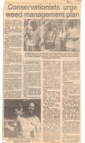
Article, Conservationists to urge weed management plan, 5/04/1989 12:00:00 AM
Article from Nunawading Gazette dated 5 April 1989 about a weed management plan in the City of Nunawading.environment, weeds, victoria. department of conservation, forests and lands., native plants, edwards, margaret, meagher, dorothy, witherspoon, cameron, david -
 Rutherglen Historical Society
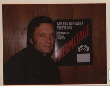
Image, 1970s
Photo of Harry Tinson who was winemaker at Baileys in Glenrowan from 1968 until 1982. An ageing Alan Bailey (greatgrandson of founder Richard Bailey) sold the winery to Davis Consolidated Industries (mainly a gelatine producer). At the time Harry Tinson, with a Master’s degree in physical engineering, was in the corporate planning department of Davis. The board had decided it wished to diversify into wine production and Tinson was charged with the responsibility of finding a suitable target. He came up with Baileys, and was instructed to negotiate the purchase of a 50 per cent share in the business. Bailey said “all or nothing” ! (James Halliday – news article 22/01/2011)Colour transparency photograph of a man standing in front of a timber panelled wall, featuring an advertising poster for Baileys Bundarra Vineyardswineries, north east victoria, wine industry, baileys, winemaker -
 Bendigo Historical Society Inc.
Document - LIST OF MAPS, PLANS, REPORTS PUBLISHED BY MINES DEPARTMENT VICTORIA 1938
... and other publications of the Mines Department of Victoria. Issued ...Blue booklet, on front ' List of Maps, Plans, Reports and other publications of the Mines Department of Victoria. Issued by Geo Brown Secretary for Mines under the authority of The Hon. E.J. Hogan, MLA, Minister of Mines. Booklet contains list of publications of geological reports, maps etc for Ararat, Ballarat, Beechworth, Bendigo, Castlemaine, Gippsland, Maryborough.Geo Brown, Secretary for Mines under the authority of The Hon.E.J. Hogan, M.L.A. Minister of Mines.organisation, government, geological maps list -
 Bendigo Historical Society Inc.
Document - PETER ELLIS COLLECTION: CONTRACT OF SALE
Copy of Contract of Sale of Real Estate and associated papers for property located in Flora Lane, Flora Hill which was purchased by Peter Ellis on 26 May 1993. Contract is in booklet with other loose papers. Contract includes General Conditions, Particulars of Sale, Special Conditions, Guarantee, Vendors Statement to the Purchaser, Shire of Strathfieldsaye Land Information Certificate, Planning Certificate Request for Building Approval Particulars, Coliban Region Water Authority Information Statement, Property Inquiry Application Form, Request for Property Information from Vic roads, Advice on Mine Subsidence Hazard (Department of Energy & Minerals), Map, Copy of Certificate of Title and Folder Numbers. Loose pages include Building Control Act 1981 Inspection Notice, two plans of building, Three plans (Coliban Water Asset Location) of Flora Lane where property is situated, 2 dated 13/11/2007 (have New Carport drawn beside house) and 1 dated 22/11/2007. Last page has specifications for car port.bendigo, house, peter ellis oam, peter ellis collection, reiv, law institute of victoria, real estate institute of victoria ltd, e j gannaway, peter n ellis, ray white bendigo pty ltd, e m monotti & son, rogers and every, craig watts, shire of strathfieldsaye, coliban region water authority, sec, g & fc of vic, telecom, vicroads, bruce l phillips, k deps?, department of energy and minerals, robert james sanderson, t flanagan, land titles office victoria, harston partridge & co pty ltd -
 Bendigo Historical Society Inc.
Document - BERT GRAHAM COLLECTION: BENDIGO EAST SWIMMING CLUB, 20/11/1962
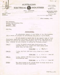
Documents, Bert Graham Collection, Bendigo East Swimming Club, from Australian Electrical Industries P/L Melbourne, 20th November 1962 on pricing for Floodlighting of the pool. State Electricity Commission of Victoria, Electricity Supply Department Melbourne, recommended lighting for the Pool in a letter and with a plan of such lighting.bendigo, clubs, floodlighting for bendigo east swim -
 Bayside Gallery - Bayside City Council Art & Heritage Collection
Map, Department of Crown Lands and Survey et al, Moorabbin, County of Bourke, Government Roads, 1920
The cadastral map of the Parish of Moorabbin in Victoria (L.6104) shows parish boundaries and land ownership 1920 when Sandringham was a Town. The government roads have been coloured in red pencil.moorabbin, county of bourke, map, plan, land subdivision, land titles, foreshores, hampton, beaumaris, highett, cheltenham, department of lands and survey, land owners, cartographic material, brighton, sandringham, town of sandringham, government roads -
 Bayside Gallery - Bayside City Council Art & Heritage Collection
Map, Department of Crown Lands and Survey, Moorabbin, County of Bourke, c. 1918
The cadastral map of the Parish of Moorabbin in Victoria (L.6104) shows parish boundaries and land ownership c. 1918 when Sandringham was a Borough.moorabbin, county of bourke, map, plan, land subdivision, land titles, foreshores, sndringham, hampton, beaumaris, highett, cheltenham, department of lands and survey, land owners, cartographic material, borough of sandringham, brighton -
 Kew Historical Society Inc
Plan, Melbourne & Metropolitan Board of Works : Borough of Kew : Detail Plan No.1576, 1904
The Melbourne and Metropolitan Board of Works (MMBW) plans were produced from the 1890s to the 1950s. They were crucial to the design and development of Melbourne's sewerage and drainage system. The plans, at a scale of 40 feet to 1 inch (1:480), provide a detailed historical record of Melbourne streetscapes and environmental features. Each plan covers one or two street blocks (roughly six streets), showing details of buildings, including garden layouts and ownership boundaries, and features such as laneways, drains, bridges, parks, municipal boundaries and other prominent landmarks as they existed at the time each plan was produced. (Source: State Library of Victoria)This plan forms part of a large group of MMBW plans and maps that was donated to the Society by the Mr Poulter, City Engineer of the City of Kew in 1989. Within this collection, thirty-five hand-coloured plans, backed with linen, are of statewide significance as they include annotations that provide details of construction materials used in buildings in the first decade of the 20th century as well as additional information about land ownership and usage. The copies in the Public Record Office Victoria and the State Library of Victoria are monochrome versions which do not denote building materials so that the maps in this collection are invaluable and unique tools for researchers and heritage consultants. A number of the plans are not held in the collection of the State Library of Victoria so they have the additional attribute of rarity.Original survey plan, issued by the MMBW to a contractor with responsibility for constructing sewers in the area identified on the plan within the Borough of Kew. The plan was at some stage hand-coloured, possibly by the contractor, but more likely by officers working in the Engineering Department of the Borough and later Town, then City of Kew. The hand-coloured sections of buildings on the plan were used to denote masonry or brick constructions (pink), weatherboard constructions (yellow), and public buildings (grey). Development in the 20th century has irreparably altered that part of Kew represented in this plan. In the block bounded by Cotham Road, Charles Street, Wellington Street and Gellibrand; just one house standing in 1903 remains. This block included two of the most historic houses in Kew: ‘Ordsall’ (later ‘Southesk’) and ‘Madford’ (previously ‘Elm Lodge’). Ordsall was the home of the second chairman of Kew, John Halfey. It contained some of the most significant interior murals in Kew, created for Halfey by artists working for Cullen & Co. It was demolished in 1960 to make way for the Kew Civic Centre. Elm Lodge had been built for William Siddeley in ca. 1864. Arthur Septimus King purchased it in 1874. The lower paddocks of Madford were sold in 1905 by his wife to the Borough of Kew and, after landscaping by George and Thomas Pockett, opened as the Alexandra Gardens in 1908. Elm Lodge/Madford was in 1922 to become St. Anthony’s Home for Little Children before its subsequent demolition in the 1980s.melbourne and metropolitan board of works, detail plans, maps - borough of kew, mmbw 1576, cartography -
 Kew Historical Society Inc
Plan, Borough of Kew Detail Plan No.1577, 1904
The Melbourne and Metropolitan Board of Works (MMBW) plans were produced from the 1890s to the 1950s. They were crucial to the design and development of Melbourne's sewerage and drainage system. The plans, at a scale of 40 feet to 1 inch (1:480), provide a detailed historical record of Melbourne streetscapes and environmental features. Each plan covers one or two street blocks (roughly six streets), showing details of buildings, including garden layouts and ownership boundaries, and features such as laneways, drains, bridges, parks, municipal boundaries and other prominent landmarks as they existed at the time each plan was produced. (Source: State Library of Victoria)This plan forms part of a large group of MMBW plans and maps that was donated to the Society by the Mr Poulter, City Engineer of the City of Kew in 1989. Within this collection, thirty-five hand-coloured plans, backed with linen, are of statewide significance as they include annotations that provide details of construction materials used in buildings in the first decade of the 20th century as well as additional information about land ownership and usage. The copies in the Public Record Office Victoria and the State Library of Victoria are monochrome versions which do not denote building materials so that the maps in this collection are invaluable and unique tools for researchers and heritage consultants. A number of the plans are not held in the collection of the State Library of Victoria so they have the additional attribute of rarity.Original survey plan, issued by the MMBW to a contractor with responsibility for constructing sewers in the area identified on the plan within the Borough of Kew. The plan was at some stage hand-coloured, possibly by the contractor, but more likely by officers working in the Engineering Department of the Borough and later Town, then City of Kew. The hand-coloured sections of buildings on the plan were used to denote masonry or brick constructions (pink), weatherboard constructions (yellow), and public buildings (grey). MMBW Plan No.1577 includes some of the most significant houses in Kew: Herbert Henty’s ‘Roxeth’ (now part of Trinity Grammar), ‘Butleigh Wooton’, ‘Bokara’ and ‘Harrow’. It also includes the streets that have since changed their names. That part of College Parade linked to Glenferrie Road is now named College Place, College Parade now extends further north, and Charles Street did not yet reach Barkers Road. Roxeth is one of a number of Henty houses in Kew. Herbert Henty made his home here and was elected a member of Kew Municipal Council in 1864 and mayor in 1868-69. Walter Henry Serle, of Harrow served in the First World War. He was awarded the Military Medal ‘’For conspicuous bravery and devotion to duty. On 29th September near BELLICOURT he showed the greatest bravery and determination when his platoon was attacked by enemy bombing parties. It was due largely to his personal efforts that all the attacks were repulsed. Until wounded, his utter disregard of personal safety and boldness in dealing with the attacks were the means of saving the situation and were an inspiring example to his men.’melbourne and metropolitan board of works, detail plans, maps - borough of kew, mmbw 1577, cartography -
 Kew Historical Society Inc
Plan, Melbourne & Metropolitan Board of Works : Borough of Kew : Detail Plan No.1578, 1904
The Melbourne and Metropolitan Board of Works (MMBW) plans were produced from the 1890s to the 1950s. They were crucial to the design and development of Melbourne's sewerage and drainage system. The plans, at a scale of 40 feet to 1 inch (1:480), provide a detailed historical record of Melbourne streetscapes and environmental features. Each plan covers one or two street blocks (roughly six streets), showing details of buildings, including garden layouts and ownership boundaries, and features such as laneways, drains, bridges, parks, municipal boundaries and other prominent landmarks as they existed at the time each plan was produced. (Source: State Library of Victoria). This plan forms part of a large group of MMBW plans and maps that was donated to the Society by the Mr Poulter, City Engineer of the City of Kew in 1989. Within this collection, thirty-five hand-coloured plans, backed with linen, are of statewide significance as they include annotations that provide details of construction materials used in buildings in the first decade of the 20th century as well as additional information about land ownership and usage. The copies in the Public Record Office Victoria and the State Library of Victoria are monochrome versions which do not denote building materials so that the maps in this collection are invaluable and unique tools for researchers and heritage consultants. A number of the plans are not held in the collection of the State Library of Victoria so they have the additional attribute of rarity.Original survey plan, issued by the MMBW to a contractor with responsibility for constructing sewers in the area identified on the plan within the Borough of Kew. The plan was at some stage hand-coloured, possibly by the contractor, but more likely by officers working in the Engineering Department of the Borough and later Town, then City of Kew. The hand-coloured sections of buildings on the plan were used to denote masonry or brick constructions (pink), weatherboard constructions (yellow), and public buildings (grey). MMBW Plan No.1578 is significant in that it defines the extent of two private schools: Xavier College and Kew High School (now part of Trinity Grammar) by 1904. In relation to the latter, the plan clarifies which buildings the High School operated from behind the mansion ‘Molina’. Established in 1902, Trinity Grammar was to later lease and subsequently buy Molina (now ‘Merritt House’) and ‘Elsinore’ (now ‘Roberts House’). Xavier College had been established in 1872. This 1904 plan delineates the West Wing and the Great Hall (built in 1890).melbourne and metropolitan board of works, detail plans, maps - borough of kew, mmbw 1578, cartography -
 Kew Historical Society Inc
Plan, Melbourne & Metropolitan Board of Works. Borough of Kew Detail Plan No.1579, 1904
The Melbourne and Metropolitan Board of Works (MMBW) plans were produced from the 1890s to the 1950s. They were crucial to the design and development of Melbourne's sewerage and drainage system. The plans, at a scale of 40 feet to 1 inch (1:480), provide a detailed historical record of Melbourne streetscapes and environmental features. Each plan covers one or two street blocks (roughly six streets), showing details of buildings, including garden layouts and ownership boundaries, and features such as laneways, drains, bridges, parks, municipal boundaries and other prominent landmarks as they existed at the time each plan was produced. (Source: State Library of Victoria). This plan forms part of a large group of MMBW plans and maps that was donated to the Society by the Mr Poulter, City Engineer of the City of Kew in 1989. Within this collection, thirty-five hand-coloured plans, backed with linen, are of statewide significance as they include annotations that provide details of construction materials used in buildings in the first decade of the 20th century as well as additional information about land ownership and usage. The copies in the Public Record Office Victoria and the State Library of Victoria are monochrome versions which do not denote building materials so that the maps in this collection are invaluable and unique tools for researchers and heritage consultants. A number of the plans are not held in the collection of the State Library of Victoria so they have the additional attribute of rarity.Original survey plan, issued by the MMBW to a contractor with responsibility for constructing sewers in the area identified on the plan within the Borough of Kew. The plan was at some stage hand-coloured, possibly by the contractor, but more likely by officers working in the Engineering Department of the Borough and later Town, then City of Kew. The hand-coloured sections of buildings on the plan were used to denote masonry or brick constructions (pink), weatherboard constructions (yellow), and public buildings (grey). While MMBW Plan No.1579 does not include many buildings, those that it does show are significant to Kew’s history. These include the ‘Kew [Railway] Station’ in Denmark Street and the ‘Recreation Hall’ and rear courts off Wellington Street. The plan shows the outline of the Recreation Hall, constructed in 1880, at the rear of which is listed a bowling green, two tennis courts, a ‘skittle alley’ and a pavilion. When the Hall was first built, the Kew Cricket Club occupied an adjacent ground, however in 1885 this was acquired by the State Government as the future location of the Kew Railway Station. The Plan also shows a single oval at Xavier College. This oval was completed in 1883. One of the current ovals conforms to this oval’s original shape and position in the school grounds.melbourne and metropolitan board of works, detail plans, maps - borough of kew, mmbw 1579, cartography