Showing 950 items
matching victorian historical buildings
-
 Unions Ballarat
Rally Ballarat Save TAFE Group - Lydiard Street, Ballarat, 2012
The Ballarat Save TAFE campaign ran from 2012 to 2014. It was a Trades Hall and community campaign in partnership with the Australian Education Union and National Tertiary Education Union. The campaign was in response to significant financial cuts and closure of many courses by the Baillieu/Napthine governments. Availability of TAFE in Ballarat is particularly important in training future tradespersons and future provision of many services. Campaign President: Athan McCaw Campaign Vice-President: Brigid O'Carroll Walsh Campaign Secretary and Treasurer: Brett Edgington During the campaign, Premier Ted Baillieu visited Ballarat on several occasions only to be met by angry groups of citizens who were opposed to his government's decimation of Victorian TAFE. The picture shows one of the early rallies convened by the Ballarat Save TAFE Group and features Ted Baillieu entering a building in Lydiard Street, television reporters and a very noisy large group of protesters. As above (see historical information).jpeg filebtlc, ballarat trades and labour council, ballarat trades hall, tafe, union campaigns, baillieu, edward (ted), napthine, denis, education and training, nteu - national tertiary education union, aeu - australian education union -
 Lakes Entrance Regional Historical Society (operating as Lakes Entrance History Centre & Museum)
Photograph, Fish Marie, 1982
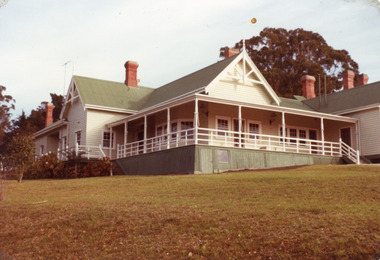
Also two other photographs of derelict farm buildings at Nyerimilang Park, Kalimna West, Victoria.Colour photograph of homestead taken at Nyerimilang Park soon after purchase by Victorian State Government. Kalimna West Victoriahouses -
 Lakes Entrance Regional Historical Society (operating as Lakes Entrance History Centre & Museum)
Postcard, 1940 c
Black and white postcard showing a sedan driving by the Victorian Border sign East Gippsland Victoriabuildings, fire brigade -
 Numurkah & District Historical Society
Victorian art print - fairy
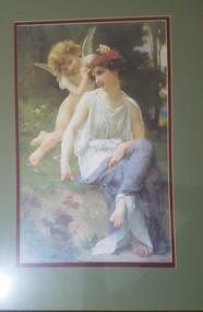
Gold embossed wooden frame with a Victorian Arts print (fairy)fairy, print, gold frame -
 Numurkah & District Historical Society
Walata Tyamateetj - Aboringal people in Victoria Book
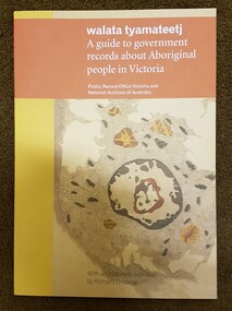
Donated to Museum via GV Library4 x books: Walata Tyamateetj - A guide to government records about Aboriginal people in Victoria PROV &NAAbook, aboriginal, gv library, records, guides, victorian government -
 Numurkah & District Historical Society
Books - Victorian Municipal Directories / Court Ledger
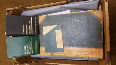
2 x Victorian Municipal Directories 1974/1992 Bank Insolvency estates - Numurkah District Old photo from court house Court case ledgercourt ledger, municipal directories, bank insolvency forms, photo -
 Numurkah & District Historical Society
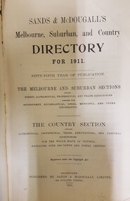
Victorian Directory
Bought at Lancefield Antiques Shop in19961 x book - 1911 Directory for City & Suburban Streets, Trades, Country Towns, Holiday Resorts, Vic parliament, Jp's, etc victorian directory, 1911, book, municipalities, towns, businesses -
 Numurkah & District Historical Society
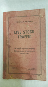
Victorian Railways Livestock Traffic Instruction Book, 1967
Booklet with heading "Livestock Traffic" produced by Victorian Railways, 1967 Contains information about transport vans, dimensions, weight, etc See photo victorian railways, livestock, transport, cattle wagons -
 Numurkah & District Historical Society
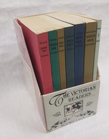
Set of "Victorian Readers"
This set of readers was a reprint,by the Victorian Ministry of Education, of the original readers first published in 1926 This set was presented to Marian Houghton (teacher) by a parent as a memento of her own school days "But they are not the quality of the ones we used as kids. The original had hard covers"Set of 8 "Victorian Readers" reprinted in 1986. Presented in a cardboard box (brochure box style)The Victorian Readers Books 1-8 -
 Numurkah & District Historical Society
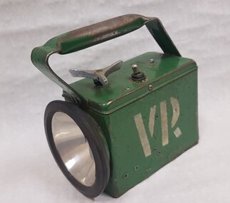
Equipment - Victorian Railway Torch
Victorian Railway equipment belonging to the Numurkah Railway Station (now closed)Green rectangle box with handle, circular light in the front with black rubber ring around light. Top of box has a tri handle turner and a flick switchAppleton Brisbane. White VR printed on both length sides -
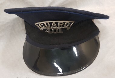 Numurkah & District Historical Society
Textile - Victorian Railway Guard Hat
Victorian Railway Guard Hat, Navy cloth with black face brim. Has black band around the base of the hat. Red interior lined Metal Badge Guard 401 -
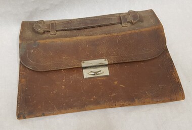 Numurkah & District Historical Society
Equipment - Leather Satchel
Leather satchel with leather handle held by leather bindings and metal clasp. No longer has stitching on sides (possibly Victorian Railways) -
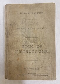 Numurkah & District Historical Society
Book, Victorian Railways Rolling Stock Branch Book of Instructions
Cloth covered book dated October 1921.By Authority Albert J Mullett, Government Printers Melbourne 13911-R1123/21. Has Diagrams, contains 257 pagesO Baker -
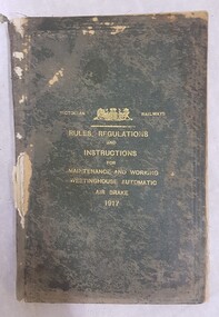 Numurkah & District Historical Society
Book - Victorian Railways Book, Rules, Regulations & Instructions for maintenance and working Westinghouse Automatic Air Brake 1917
Part of a collection of old railway items from closed Numurkah Railway StationGreen covered hardcover bookTitle (as above) / Victorian Railways heading and coat of arms -
 Numurkah & District Historical Society
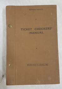
Book, Victorian Railways Ticket Checkers' Manual
Brown hard cover, loose pages secured by 1 metal screw (1 is missing). Note inside cover Obsolite 30.3.82. Also contains Manual of ticketsEffective from 1st January 1961 -
 Numurkah & District Historical Society
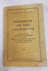
Book, Victorian Railways Handbook on the Locomotive
Part of a collection from the closed Numurkah Railway StationCream cloth/woven covered book Title as above / Issued for the guidance of enginemen in the description, maintenance and economical operation of the locomotive 1952 -
 Numurkah & District Historical Society
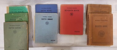
Book - Victorian Readers x 9, Victorian Readers Fifth Book (4) / Victorian Readers Sixth Book (2) / Victorian Readers Seventh Book ( 1) / Victorian Readers Eighth Book (2)
9 x Victorian Readers books, Cardboard covers, various colours depending on year level (see photo)Victorian Readers with Education Department logoeducation, school, reading, readers, english -
 Queen Victoria Women's Centre
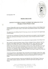
Media Release, Eminent Victorian Women Support the Shilling Fund, 23 September 1996
A4 sized paper. 4 pages. charitable organisations, women social services, women historic sites, historical building -
 Otway Districts Historical Society
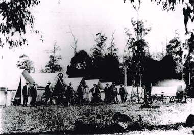
Photograph, Knox Collection, Survey camp for Colac-Beech Forest railway, 1901, 1901
Plans for a rail connection between Colac and Beech Forest had been drawn up in 1884 and 1889 but proofed inconclusive because of the enormous cost involved in building a railway in such difficult terrain. Because of the financial depression in the early 1890s such expenditure went of hold. Towards the end of the decade planners recognised that a narrow gauge could be a viable alternative and it was taken up by the community, Parliamentary representatives and the government, although Victorian Railways administration was against the idea. This was overridden. The 1898 Parliament approved a 2 foot 6 inch gauge from Colac to Beech Forest although strict financial limits were set. The route was to be the most direct and the infrastructure the most basic. Construction began in 1900 entailing very steep grades and myriad curves until it finished in 1902. Surveyors and their assistants came before and during the track laying for the whole distance.B/W. Survey camp for the Colac-Beech Forest railway in 1901, showing nine tents, ten men including a cook, survey instruments, and three bicycles. Note the cooking fire on the right.colac: beech forest; railways; survey; -
 Bendigo Historical Society Inc.
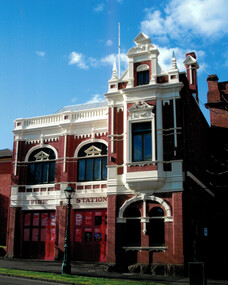
Document - Bendigo Fire Station View Street, 1960-1980s
In 1889 the three central fire brigades of Bendigo were amalgamated and a new fire station was erected in View Street (the third to be built on this site). This two storied brick building designed by Wm. Beebe forms an integral past of the View Street landscape. The red brick, white plaster relief trimmings and window frames with greenish lead-light decoration, all reflect the late Victorian style of the building. The ground floor contained an engine station and call room with stalls to accomodate three horses immediately behind. Upstairs in the main building is a handsome drill hall.Series of letters between Miss Starke and Miss Mathison re classification of the building by the National Trust; Letter to the Country Fire Authority (CFA) re classification; Media Release; National Trust data survey form; two photos of the fire stationhistory, national trust bendigo collection, bendigo, bendigo fire station -
Bendigo Historical Society Inc.
Document - Heritage Bid For Central Victorian Goldfields, 1981
Invitation to Public Launch, Programme for the launch, Burra Charter - International Charter for the Conservation and Restoration of Monuments and sites, Building included in the initial Register.history, national trust bendigo collection, bendigo, central goldfields, nell gwynne mine, north virginia mine -
Bendigo Historical Society Inc.
Audio - Making Tracks, c1980s
Bendigo Workshops is a railway workshop in Bendigo, Victoria, Australia. It is located in the north of the city beside the junction of the Swan Hill and Deniliquin railway lines. The site covers 10.3 hectares of land and has 31 separate buildings, including a 10,000 sqm main workshop building and six kms of railway track. The workshops were opened in November 1917 by the Victorian Railways. It opened in response to political pressures from provincial groups for decentralization, with the Victorian Railways preferring the cheaper option of expanding the existing Newport Workshops in suburban Melbourne. The 1980s were a time of restructuring, and on the breakup of the Victorian Railways the workshops passed to the State Transport Authority and then the Public Transport Corporation.Three Audio Files - by David Bennet, Davis Moon and Kevin Whelan who worked at the Bendigo Railway Workshops. The three share their working life memories history, bendigo, bendigo railway workshops -
 Bendigo Historical Society Inc.
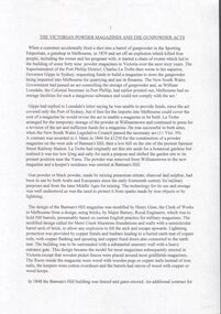
Document - Victorian powder magazines
Gunpowder is very volatile and can be ignited by the smallest spark. Several horrific accidents resulted in NSW passing legislation to cover the safe storage of gunpowder but initially these laws did not apply to Victoria. this was rectified and the first Melbourne magazine was erected on Batman's Hill in 1845. The Victorian Gunpowder Act (1857) made local councils responsible for the safe storage of gunpowder. The Victorian government made L.909 available for a suitable building in Sandhurst. Built on Camp Hill it was finished in April 1857 and the first keeper, Mr J. F. Kerr was appointed in October 1857. Late in 1857, tenders were called for the building of a keeper's residence at the siteEleven pages typewritten document titled "the Victorian Powder Magazines and the Gunpowder Acts". Author unknown.melbourne, gunpowder acts, victorian legislation, powder magazines -
 Bendigo Historical Society Inc.
Legal record - R.S.S.A.I.L.A Bendigo documents
10559a Letter to Mr. G.V. Lansell, Mr. R.F. Hyett and Mr. G.R. Wheeler, authorizing the Trustees of the Bendigo Sub-branch of R.S.S.A.I.L.A. Building and Patriotic Fund to complete the purchase of a property in Mackenzie Street Bendigo, and authorizing the Trustees to borrow £2000 to complete the purchase. Dated 19 June 1950. Letter from Solicitors Hyett. Willis and Hyett. 10559b Indemnity agreement for five members of the Bendigo Sub-branch of The Returned Sailors' Soldiers' and Airman's' Imperial League of Australia Victorian Branch ( R.S.S.A.I.L.A.) dated 22 December 1950, in relation to the purchase of (11) McKenzie Street, Bendigo and borrowing £2,000 from the Commonwealth Bank to complete a property purchase. The members being Mr. George Victor Lansell, Mr. Frederick Eustace Jackson, Mr. John William Swatton, Mr. George Robert Wheeler, and Mr. Augustus John Skehan. r.s.s.a.i.l.a bendigo branch, mackenzie street -
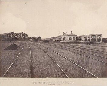 Bendigo Historical Society Inc.
Photograph - RAILWAY COLLECTION: SANDHURST (BENDIGO) RAILWAY STATION
Vistorian Railway photograph of Sandhurst (Bendigo) Railway Station and workshops buildingsVictorian Railways -
 Buninyong & District Historical Society
Photograph - B/W photograph, Dr Longden's and Sparling's former residences, Learmonth St west, Buninyong, July 1993
Dr Longden, a medical practitioner, was a significant figure in Buninyong history in the late 1800s.Brick buildings are prominent examples of Victorian era residences. Dr Longden was a prominent medical practitioner in Buninyong in the late 1800s.B/W photo of Dr Longden's (built circa 1898) and Sparling's former residences, Learmonth St west, Buninyong. Streetscape photo taken in 1993 of two brick residences.buninyong, longden, sparling, brick building, house, street scape, learmonth st -
 Buninyong & District Historical Society
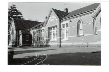
Photograph - Original B/W photograph, Buninyong State School, 18th September, 1993
Buninyong State School was built circa 1870. It is a brick building with arch-shaped windows. Used as a state school since 1874.The school is of historic and social significance as it has operated as a state/primary school since 1874. It is a good example of a Victorian era brick school building.Original B/W photo of Buninyong State School. A brick building, built circa 1870. Arch-shaped windows. Used as a state school since 1874."State School No 1270"buninyong state school, buninyong, school, buninyong primary school, brick building -
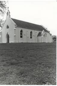 Buninyong & District Historical Society
Photograph - Original B/W Photograph, Clive Brooks, Roman Catholic Church, Fisken St. Buninyong, 19 Jul 1993
Gold rush church, subdued Victorian Gothic design, white-washed render, slate roof. B/W photo of St. Peter and St. Paul's Catholic Church, Fisken St. Buninyong, south facadebuninyong, catholic church, building, gothic revival, fisken st. -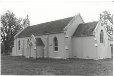
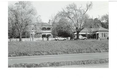
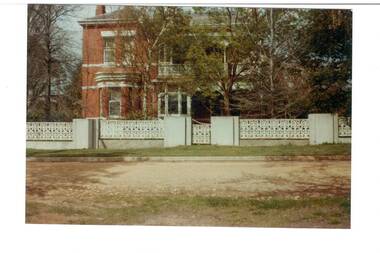 Buninyong & District Historical Society
Photograph - Original Colour Photograph, Building, Dr. Longden's home, Learmonth St. west, 1982
Record of Victorian era house in 1980's.Colour photo, Dr. Longden's house, Learmonth St. West.house, longden, surgery, doctor, learmonth st.