Showing 12852 items
matching 08/09/1945
-
 Mt Dandenong & District Historical Society Inc.
Document - Speech, Empire Day 1933
This document is a speech titled "Empire Day 1933. A message to the children at Olinda School from their member". It is signed G H Knox. It was written by Sir George Hodges Knox and read to the children at Olinda School as part of the Empire Day celebrations in 1933. Sir George Hodges Knox (1885-1960) was a veteran of WW1 and was elected to the Ferntree Gully Shire Council in 1922. He held this post until 1927.The City Of Knox is named after him. He won the Victorian Legislative Assembly seat for Upper Yarra in 1927 for the Nationalist Party. He became Speaker for the Victorian Parliament in 1942 and remained there until 1947. Between 1945 and his death in 1960 he held the seat of Scoresby. He was knighted in 1945. The celebration of Queen Victoria's birthday on May 24 was renamed Empire Day in 1903 after her death in 1901. Empire Day was observed in state schools from 1905 with a program of addresses, pageants and patriotic songs, with children swearing allegiance to King and Empire with a loyal declaration. The last celebration of Empire Day in Australia took place in 1958. Five sheets of unlined paper that appear to have been torn from a writing pad with a speech handwritten in thick, black fountain pen commemorating Empire Day.olinda school, sir george hodges knox, empire day, speech, city of knox, knox, olinda, school, celebration -
 Eltham District Historical Society Inc
Photograph - Aerial Photograph, Landata, Eltham; Crown Allotment 15, Section 5, Parish of Nillumbik (Stokes Orchard Estate), Dec. 1945
Centred on present day Diosma Rd, Stokes Pl, Nyora Rd and Eucalyptus Rd Historic Aerial Imagery Source: Landata.vic.gov.au Aerial Photo Details: Project No :5 Project : MELBOURNE AND METROPOLITAN AREA PROJECT Run : 36 Frame : 60546 Date : 12/1945 Film Type : B/W Camera : EAG4 Flying Height : 10200 Scale : 6000 Film Number : 195 GDA2020 : 37°42'47"S, 145°09'56"E MGA2020 : 338306, 5824438 (55) Melways : 22 C4 (ed. 42) A History of the Development of Crown Allotment 15, Section 5, Parish of Nillumbik – Stokes Orchard Crown Allotment 15, Section 5, Parish of Nillumbik (CA15) is a square allotment of 158 acres or approximately a quarter of a square mile. It lies just beyond the eastern end of Pitt Street, south of Nyora Road to the northern end of Eucalyptus Road and extends east from Eucalyptus Road to Reynolds Road. The topography of CA15 is generally steep, sloping up to a hill near the centre of the land, the ridgeline passing through the properties along the southern side of Diosma Road. Eucalyptus Road is a straight north-south road with its northern end at the north west corner of CA15. Until the end of the 1970s this road was an un-named Government Road and was largely not open to traffic. With residential development in the 1970s the road was constructed, and the council allocated the name obviously in recognition of the predominant species of the local bushland. CA15 was purchased from the Crown by George D’Arley Boursiquot, a prominent Melbourne printer, on 28th October 1852. On November 23, 1922, former Member for Gippsland and Melbourne Real Estate Agent, Hubert Patrick Keogh purchased the allotment then sold it March 13, 1925, to local farmer, Robert David Taylor, a former Shire of Eltham Councillor (1911-1920) and Shire President (1919). Taylor had extensive land holdings stretching west towards Bible Street and Main Road. The Taylor home was situated at the top of the hill in Bible Street at present day 82 Bible Street. At the time of Taylor’s purchase in 1925, CA15 was subdivided into 48 lots that could be described as small rural properties or large residential lots. A typical lot size was one hectare or 2.5 acres. The subdivision created two roads, Nyora Road, and Diosma Road, each following an irregular alignment between Eucalyptus and Reynolds Roads. However, the lots were not sold off separately nor were the roads constructed. The land effectively remained as one parcel for many further years. Robert David Taylor died November 30, 1934, and probate was granted to his son of the same name, Robert David Taylor of Bible Street, Salesman and William McLelland Vance Taylor of 73 Emmeline Street, Northcote, Clerk, with the transfer of the land into their names on July 8, 1935. Frank Stokes worked as a qualified accountant at Kennons leather factory in Burnley, while living at 1 Thomas Street, Mitcham. He suffered from migraines and wanted to return to working the land (he had previously worked on farms and orchards since coming to Australia from England in 1926, both in WA and Vic.). He first travelled to the district by train in July 1942 to find land with the intention to establish an orchard. By chance he met Arthur Bird of Bird Orchard (bounded by Pitt Street, Eucalyptus Road, and Wattle Grove) and they got talking over their common interest. Arthur put Frank up for the night and pointed out the land, 158 acres- part of the Taylor Estate- £900, Crown Allotment 15, Section 5, Parish of Nillumbik (CA15) somewhat diagonally opposite Bird Orchard. Stokes applied through the Riverina Agency to purchase the land who in turn applied for permission from Canberra to sell as there was a new government regulation introduced during the Second World War banning land sales except for immediate production. Stokes obtained a loan on his Mitcham house of £600 @ 5% and paid £450 deposit with quarterly payments of £15 spread over 5 years. Stokes was assisted and advised by Arthur Bird who farmed the neighbouring orchard. In early 1943 Stokes took possession and would catch the train out to Eltham on Fridays after work and began building a hut on the corner of Nyora Road and the Government Road (Eucalyptus Road) for shelter and to lock up tools. He established an orchard on the central western part of the land through the centre of which ran a natural waterway (part of the present-day linear park) and was able to pay a neighbour (Hawkins) to help with clearing and fencing 25 acres, and with a horse and single furrowed plough, planted approximately 2,500 fruit trees - cherries, peaches, plums, almonds, pears, apricots and lemons as well as a few apples and oranges; a massive task. Aerial photographs from the 1940s through to the 1990s clearly show the orchard with most of the larger CA15 site remaining as natural bushland. A huge problem was hares and rabbits eating all the new buds off the tiny trees. As well as laying poison he painted the trees with a mixture of cow manure and lime, often working by moonlight. Procurement of wire and wire netting was difficult because of the war but after much effort he obtained a permit from the Agricultural Department for supplies in March 1944. In February 1945 Stokes applied for a permit to build a “packing shed” as no house building was allowed. It was to be 33 feet x 21 feet and cost £312. It was constructed mostly from second-hand materials, which were hard to obtain, especially iron for roofing. Stokes finished work at Kennons on October 31, 1945, and in March 1946 he sold the family home at Mitcham for £1,230 plus £170 for furniture. On May 15, 1946, title to the CA15 property was issued to Frank Howard Alfred Stokes, Orchardist and Gladys Ethel Stokes, Married Woman, both of Pitt Street, Eltham. The family of five then moved into the very unfinished “packing shed” at Eltham, which was a struggle to weatherproof. Eventually rooms were divided off and lined with hessian bags and whitewashed. Their income was firewood (cut and sold), selling rockery stones and cut Sweet Bursaria. (It was discovered during the 1940s that Sweet Bursaria contained the sunscreen compound Aesculin. The RAAF utilised this compound from Sweet Bursaria during WW2 for pilots and gunners.) The orchard’s first fruit sale was a half-case of Le Vanq peaches in December 1947 for the price of 8 shillings. In 1956 plans for house were drawn and Glen Iris bricks purchased (1956 Olympic Rings variant). The building of the house commenced in 1957 - 12 feet of original packing shed was removed – and was completed in 1959. Water was connected from newly built pressure storage on the property at the end of 1959 and the electricity connection for the first time at 3pm on April 29, 1960. The house remains to present day (somewhat modified) at 1 Nyora Road, home to Nyora Studio Gallery. On occasions, spare remnants of the 1956 bricks have been known to be unearthed in gardens on the estate as they were utilised by Frank Stokes to fill in rabbit holes. On May 26, 1950, a parcel of land was compulsorily acquired by the Melbourne and Metropolitan Board of Works on the hilltop to establish an easement for a high-level service reservoir to augment Eltham’s water supply. The project also included pipe tracks for the necessary water mains. The reservoir has now been superseded by higher level water tanks east of Reynolds Road and its former site is now a public reserve. On November 27, 1964, the State Electricity Commission served notice to compulsorily acquire a further parcel through the eastern part of the land for a major electricity transmission line that augmented supply from the La Trobe Valley to Melbourne. The easement was registered February 11, 1966. The easement was widened July 18, 1969 for a second transmission line to be constructed. In 1971 Melbourne Metropolitan Planning Scheme amendments adopted Nyora Road as the boundary between a residential zone to the north and a rural zone to the south. This determined the future development of the land. In the mid-1970s the Shire of Eltham divided the orchard into numerous rate-able parcel lots, the 48 lots having been established in 1925 and the subsequent rates assessment proved unsustainable for Stokes. He commenced selling lots outside the boundary of the orchard, north of Diosma and South of Nyora. However shortly later the land between Nyora and Diosma Roads and west of the electricity easement was sold and subdivided into residential lots, a housing development by Macquarie Builders and marketed as the Stokes Orchard Estate. New streets were created, and most were named after trees, although one, Stokes Place, commemorates the former owners. The development was undertaken in two stages; Stage 1 (1975) encompassing Scarlet Ash Court, Ironbark Close and Peppermint Grove bounded by Nyora and Eucalyptus roads and Stage 2 (1978) encompassing Stokes Place, Orchard Way, The Crest and The Lookout bound by Nyora and Diosma roads. The developer, Macquarie Builders went bankrupt shortly after the release of Stage 2 leaving many purchasers to fend for themselves and arrange for their own independent builders. There were also difficulties with sewerage for the land immediately south of Diosma Road and so the conventional residential lots were abandoned in favour of larger lots. The development of Orchard Way, The Crest and The Lookout did not proceed as planned and the proposed lots were incorporated into five-acre parcels instead. These included a low-density group housing development by the Graves family and the award winning Choong House (1983) with Gordon Ford developed garden immediately next door situated on the ridge of the hill nestled amongst the original bush, Eucalypt trees and Sweet Bursaria. In 1994, Nillumbik Shire Council applied Significant Environment and Significant Landscape overlays upon the properties on the south side of Diosma Road to ensure protection of this natural bush garden environment. With the arrival of the sewer along Diosma Road in the 1990s, most of these five-acre parcels have since been subdivided multiple times. The Choong house presently sits on a 2.7-acre property, which in 2022 Nillumbik Council nominated for Cultural Significance Heritage protection and is considered potentially significant at State level. The Stokes family were also associated with the Eltham Christian Church. In the 1970s this church had met in temporary premises in Eltham. Lots of the original 1925 subdivision remained south of Nyora Road and a number of these lots were utilized for the Eltham Christian School, which was established by the Eltham Christian Church in 1981. The school operated on this site until 2000. The premises are now used by The Vine Baptist Church. By the mid-1980s the whole of CA15 had been developed for residential and school purposes, except for the sections north of Diosma Road and between the transmission lines and Reynolds Road. Sewerage issues had been resolved for the section north of Diosma Road and in 1987 it was in the process of being subdivided into residential lots. The development coincided with the discovery of colonies of the rare and endangered Eltham Copper Butterfly on the site. This resulted in a community and political campaign to save the butterfly habitat. With the co-operation of the land developer the subdivision was altered to create two bushland reserves in the critical butterfly habitat areas. In the late 1980s the State Government was investigating options for establishing a metropolitan ring road link between Diamond Creek and Ringwood. The chosen route was adjacent to Reynolds Road and so this created a freeze on development of CA15 between Reynolds Road and the electricity easement. The ring road proposal was eventually abandoned, and this part of the land was subdivided into low density residential lots. Diosma Road has been discontinued at the electricity easement and the eastern part incorporated into View Mount Court with access from Reynolds Road. The whole of CA15 has now been developed for residential or associated purposes, ranging from conventional density to quite low density south of Nyora Road. Some remnants of the orchard remain, a few cherry trees on the Graves property and a lone apple tree in Stokes Place. The butterfly reserves comprise significant areas of remnant bushland. Linear reserves through the estate link with central Eltham via the Woodridge linear reserve and with Research along the electricity easement. CA15 as it exists today has a complicated history of rural use, Government acquisition, urban development, and community action. References: • “Stokes Orchard, an incomplete history”; Russell Yeoman with Doug Orford • Correspondence, Beryl Bradbury (nee Stokes) • Aerial Photographs, 1931-1991, Landata (landata.vic.gov.au) • Certificate of Title, Vol. 4930 Fol. 985900 • Plan Number LP 10859 aerial photo, diosma road, eltham copper butterfly, eucalyptus road, ironbark close, nyora road, peppermint grove, peter & elizabeth pidgeon collection, power transmission lines, reynolds road, scarlet ash court, stokes orchard estate, stokes place, woodridge estate, frank stokes -
 Colac RSL Sub Branch
Decorative object - Baulch Brothers. Their Service - Our Heritage. Photo/Badge Collection, Baulch Family, 2008
Item donated to Colac RSL by the Baulch Family February 2008. Constructed of Otway Forest Blackwood. Made by Frank Nemec of Eden N.S.W High SignificanceBlackwood Timber Frame. Blue material cloth background, with photos and military badges. Banner - Blue material with gold writingPhoto Frame:- Upper Left. Private Frank Baulch. VX72238 + small Rising Sun Badge. Born 15/11/1911 at Glen Aire, Vic. Enlisted 15/2/1942 in Caulfield, Vic. Discharged 3/12/1945. 2nd/2nd Pioneer Battalion. Lower Left. Corporal Horace Baulch. VX869036 + Large Rising Sun Badge. Born 29/4/1942 at Colac, Vic. Enlisted 29/4/1942 at Seymour, Vic. Discharged 13/3/1946. H.Q. AMF School of Mechanization. Centre. Lance Corporal Stanley Baulch VX72233. Born 8/12/1914 at Gellibrand, Vic. Enlisted 19/1/1942 in Caulfield, Vic. Discharged 5/12/1945. 2nd/2nd Pioneer Battalion. Private Jack Baulch VX72232. Born 18/5/1917 at Colac, Vic. Enlisted 15/1/1942 in Colac, Vic. Discharged 29/1/1946. ? Battalion Lower Centre. Female Relatives Badges and Information sheet. Badges:- Sarah, Alice, Iris and Elizabeth Baulch. Photo Sarah and Fred Baulch. Upper Right. Alexander Baulch VX56771 + small Rising Sun Badge. Born 21/2/1919 at Collingwood, Vic. Enlisted 28/5/1942 at Royal Park, Vic. Discharged 20/11/1945. ? Batt. Lower Right. Norman Baulch. VX86902 + large Rising Sun Badge. Enlisted 28/5/1942 at Royal Park, Vic. Born 5/12/1921 at Colac, Vic. Enlisted 29/7/1942 in Seymour, Vic. Discharged 28/2/1945. ?Batt. -
 Bendigo Military Museum
Artwork, other - CARD AND PAMPHLET, 2) Sirichai Press, 1) est 1945, .2) post 1945
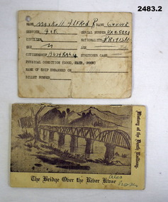
.1) Possibly a ships boarding pass on return from Japan at wars end..2) 3 Pagodas was a place on the Burma Railway. Items belonged to Alfred Robert Maskell VX25221, 4th Anti Tank Regt 2nd AIF. Refer 2485 for medals and service history also 1076, 1100.2, 2489P. .1) Card, printed in black with hand written details on one side, rear is lined. The card details name, rank, sex, civilian, physical condition, name of ship embarked on, billet No. .2) Pamphlet, "The Bridge on the River Kwai, history of the Death Railway". Front has a drawing of the bridge, rear has depiction of the "3 Pagodas", 12 pages."Maskell Alfred R, Gunner AIF VX25221 British-M-Australia"identification, burma railway, ww2 -
 Bendigo Military Museum
Badge - BADGES, MEMBERSHIP, 1939 - 1945, post 1945
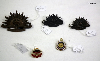
.1) Hat badge, Rising Sun, pressed blackened brass, rising sun depiction with crown centre, under in scrolls "Australian Commonwealth Military Forces". On rear two lugs, sewn onto the lugs is a piece 1914 - 1918. Star Ribbon. .2) Lapel badge, Rising Sun, pressed blackened brass, 2 lugs and pin. Same as 2234.2 .3) Same as .2) .4) Badge, Life membership 39th Battalion. Top is oval shape of badge, grey surround with brown over red with "39" centre. Under in a scroll is "Life Membership". On rear is pin and clip. .5) Badge, R S L membership metal centre is a 3 figures. In blue circle around figures is "Returned, Sailors, Soldiers and Airmen". under in red scroll is "Imperial League of Australia". Top is crown with "93" denoting membership 1993. Rear has a pin attachment. Badge number stamped on. ,5 "Badge remains property of the league V 75371”badges, memmbership, uniform, rsl, rising sun -
 Bendigo Military Museum
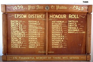
Honour Board - EPSOM DISTRICT HONOR ROLL 1939-1945, c1945-1950
This is a broad wooden Roll of Honour. At the top, there is an outwards curving section. Across the front of that are the words:- " 1939 PRO DED ET PATRIA 1945" . In the centre of the phrase is a metal Army badge of the type in use from Bendigo's 5th Battalion backwards. It is about 7 cms wide. In the centre section is varnished plywood. There are four columns of names painted in gold. The phrase - "EPSOM DISTRICT HONOR ROLL" is painted above the names. There are 45 names. One is shown as dead. One has a DFC. The left and right sides have carved wooden Doric style columns. The bottom as a box like section. On it is painted in gold:- IN THANKFUL MEMORY OF THOSE WHO SERVED".ww2, honour roll, epsom district -
 Bendigo Military Museum
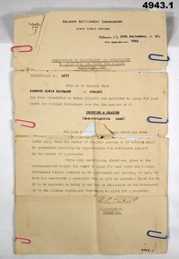
Certificate, Certificate of eligibility and suitability for soldier settlement
1. Foolscap size sheet (see condition) Letterhead is for the soldier Settlement Commission. State Public Offices. Tel F 0234. Dated Melb 16 Sep 1947. Letter No 8945. In the text is Cert No. 4677 for Kenneth Edwin Beckman of Cowangi. The purpose of the land is for cropping and grazing (non irrigation land) 2. Letter quarto size paper. Letterhead of Australian Mil Forces. Tel No. M 45966 Ext 30. Victoria Echelon and records 291 Lonsdale St Melbourne dated 2 Nov 1945. In the text is printed EX V64354 K E Beckman. Cert of Discharge 294425. RAS Badge No. A 99448. Will (AAF A.131) One..admin record, ww2 -
 City of Moorabbin Historical Society (Operating the Box Cottage Museum)
Newsletter, City of Moorabbin Historical Society Aug 2009, August 2009
The City of Moorabbin Historical Society was formed c 1960 by a group of Moorabbin residents who were concerned that the history of the area should be preserved. A good response to a call for items related to the historical area of Moorabbin Shire brought donations of a wide variety of artefacts which are now preserved by the current members of CMHS at Box Cottage Museum . Helen Stanley, Secretary of CMHS, began producing a Newsletter for members in April 2007 to provide current information and well researched items of historical interest.Helen Stanley has produced a bi-monthly Newsletter, 2007 - 2013, for the members of the City of Moorabbin Historical Society that contains well researched interesting historical items, notification of upcoming events, current advice from Royal Australian Historical Society , Museums Australia Victoria and activities of Local Historical Societies. The Newsletter is an important record of the activities of the CMHS.1 x A4 paper printed on both sides Issue 13 of the bi-monthly, City of Moorabbin Historical Society Newsletter produced by Society member and Secretary, Mrs Helen Stanley in August 2009. Notice of next meeting August 30th , and thanking Gary McInnes, CMHS , for his talk ‘The Centenary of the Bentleigh Cricket Club’ and donation of the book to our library. Gary has offered to catalogue our collection of the ‘Standard News’ 1945 – 1984. CMHS member Lesley has audited the Index of the photograph Folios. Glen Eira Council has organised maintenance on ‘Box Cottage. Item of Interest is regarding ‘New Conditions of Employment’ Sydney 1852 CITY of MOORABBIN HISTORICAL SOCIETY / AUGUST 2009 NEWSLETTERcity of moorabbin historical society, stanley helen, melbourne, moorabbin, brighton, cheltenham, ormond, bentleigh, market gardeners, pioneers, early settlers, moorabbin shire, box cottage museum, dendy’s special survey 1851, bentleigh cricket club, mcinnes gary, standard news -
 The Ed Muirhead Physics Museum
Photograph, Optical Munitions, with Optical Flat
Part of a series entitled “Optical Munitions - School of Natural Philosophy, 1942-1945”. Black and white photo showing close up of glass optical flat in case. Photographed label reads: “Glass optical flat. Made by Natural Philosophy Laboratory. Melbourne University. Certificate Number 18. Accuracy of surface, flat within .000,001 (unmarked surface). Accuracy of surface, within .000,002 inch (marked) “use other side”. A photograh in Cd red light of the interference fringes of this flat when placed on a standard glass flat is shown above. Initials: [signature]. Tests made by: [VDH signature]. Certificate issued by T.H.L. Date: Feb 19th 1941.In ink on lower left hand corner : “17”. -
 Bendigo Historical Society Inc.
Document - BASIL MILLER COLLECTION: WELCOME TO BENDIGO BROCHURE
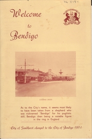
lemon coloured, bifold A4 'Welcome to Bendigo' brochure. On front ' Welcome to Bendigo' and coat-of-arms of City of Bendigo in top RH corner. Photo of Charing Cross in centre. Below photo: 'As to the City's name, it seems most likely to have been taken from a shepherd who was nicknamed 'Bendigo' for his pugilistic skill, Bendigo then being a notable figure in the ring in England' In centre 'Evolution of Bendigo tramways' 6 photos of trams: 1890 battery electric; 1903 electric traction; 1945 maximum traction; 1892 steam tram cars, 1913 open cross seat cars, 1947 Birney safety cars. On back, diagram of Bendigo Tramway routes.tramways, history, tramways brochure -
 NMIT (Northern Melbourne Institute of TAFE)
Minutes of Meetings of School Council PTS and PTC 1936-1965, Minutes of Meetings of School Council Preston Technical School and Preston Technical College 1936-1965
Bound volumes with varied coloured covers, of Minutes of Meetings of School Council. Begins with Preston Technical School then changes to Preston Technical College. 17 December 1936 - 31 December 1940 1 January 1941 – 31 December 1945 1 January 1946 – 31 December 1950 1 March 1951 – 31 December 1952 5 March 1953 – 31 December 1955 1 March 1956 – 31 December 1959 3 March 1960 - 8 March 1962 12 April 1962 - 13 March 1964 9 April 1964 - 9 December 1965. Include Lists of Staff, Annual Reports, Financial Statements. preston technical school, preston technical college, proceedings, reports, nmit -
 Ballarat Tramway Museum
Photograph - Black & White Photograph/s, State Electricity Commission of Victoria (SECV), late 1940's
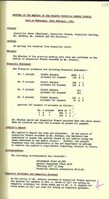
Yields information about one of the first two maximum traction bogie trams in Ballarat in October 1945 after it had been repainted for use in Ballarat by the SEC and a little photographed single truck tram No. 24. Also has pedestrians in view.Black and White photograph, No. 15 and 24 at the city stop, corner of Lydiard and Sturt Sts, with the Town Hall in the background. No 15 has the destination of Mt Pleasant. Two ladies are sitting on a seat with Reid's mens wear shop in the background. Two other ladies are walking in front of the trams. See also Reg item 3805 for a similar photograph from another angle. No. 15 2nd bogie tram to arrive, 10/1945. Renumbered to No. 36 in 1953. Presumed photo taken during 1940's. See Keith Kings, The Ballarat Tramways, page 36 and The Golden City and its tramways. Additional large prints added 21/3/2021.tramways, trams, bogie trams, town hall, city, tram 15, tram 24 -
 Ballarat Tramway Museum
Document - Photocopy, "Something Old"
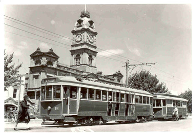
Photocopy of two photos in an unknown magazine, with the page heading of "Something Old", page 79 of: 1. - Ballarat trams No. 15 and 24 at the City terminus in Sturt St with the Town Hall in the background. No. 15 has the destination of Mt. Pleasant. (See Reg Item 3804 for a large print) 2. - Geelong trams No. 32 and two other single truck trams, at the corner of Ryie and Moorabool Streets with the T&G building in the background. No. 32 has the destination of Belmont. Photos c1950. Three copies on A4 size pager held. "The Ballarat Tramways" notes that No. 15 arrived in Ballarat October 1945 and was renumbered to No. 36 in 1953. Both photos credited to the SECtrams, tramways, ballarat, town hall -
 Bendigo Historical Society Inc.
Photograph - LA TROBE UNIVERSITY BENDIGO COLLECTION: STAFF BENDIGO TEACHERS' COLLEGE
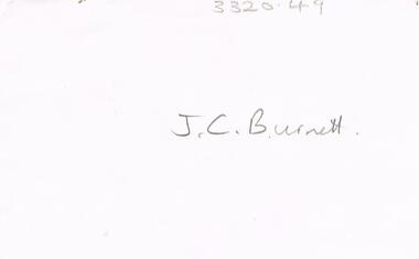
BHS CollectionA white envelope which contained four photos and on the front in grey lead is the name J.C. Burnett A black and white photograph of Ms. J.C. Burnett a staff member at Bendigo Teachers' College. A small black and white photograph of four Bendigo Teachers' College staff members - Ms. J.C. Burnett, Mr.George Mills (Principal), Mr. M. Morris and two unnamed women. Two black and white photographs of Bendigo Teachers' College staff members - 1. Ms. J. Burnett with an unknown man and 2. A small photo of Mr. M. Mills, Ms. J. Burnett and Mr. George Mills, year 1945 written on rear of photo.bendigo, education, bendigo teachers' college staff, la trobe university bendigo collection, collection, bendigo teachers' college staff, male, female, individual, person, portrait, photography, photographs, photograph, bendigo, education, photo, envelope, bendigo teachers' college staff, ms. j.c. burnett, teacher training, tertiary education -
Ringwood and District Historical Society
Envelope, Packet 3 St Paul's Anglican Church, Ringwood, Circa 1920s-1990s
Various newsletters and local church records circa 1920s-1990s as follows: 4940-01 Parish Messenger – Easter 1927 4940-02 Parish Messenger – April, No.42 4940-03 Anglican News – November, No.15 4940-04 Parish Paper – April 1937 4940-05 Parish News Supplements – June 1969, August 1969, September 1969, April 1977 4940-06 List of Memorials in St. Paul’s Ringwood - 1971 4940-07 Civic Service, 30th Anniversary City of Ringwood – June 1990 4940-08 Opening and dedication of “Glamorgan Court” - 1989 4940-09 Civic Service Commemorating Proclamation of City of Ringwood – 20th March 1960 4940-10 Institution and Induction of The Reverend Douglas G. Edmonds - 12th December 1989 4940-11 Last Service at St Paul’s in Ringwood Street – 28th May 1967 4940-12 Catalogue, Art Exhibition – March/April 1979 4940-13 (duplicate entry deleted) 4940-14 Parish News “Spiritus Gladius” Centenary Celebration - 1979 4940-15 St.Paul’s Centenary Worship – 14th October 1979 4940-16 Service/Newsletter pamphlets - January to April 1996 (incomplete collection) 4940-17 Advertisement for New Theatre "Polling Day" concert at church hall (near Post Office) - 1961 4940-18 Commissioning of Penny Charters, Janice Dear, and David Jones as students in ministry 4940-19 Funeral Service for late Floss Davidson (Ms. V. Boulter) 19 January 1979 4940-20 Service of Thanksgiving for Rev. John & Mrs. Helen Howells - 18 June 1989 4940-21 Bush Church Aid 70th Anniversary, St Paul's Ringwood - 1 October 1989 4940-22 Parish Baptism, Confirmation and Eucharist - 12 November 1989 -
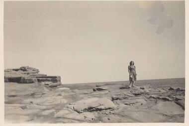 Phillip Island and District Historical Society Inc.
Photographs, 1939
A group of 26 photographs collected by Ralph Andrews, father of Michele Spencer donor. Michele sent the photographs with a covering letter explaining how her father had kept to collection for many years so she felt they should go to a good home for safe keeping. Michele's husband's uncle, Frank Spencer, was the Post Master at Cowes for many years.219-01. Photograph of lady standing on rocks at San Remo 219-02. Photograph of rocks at Back Beach San Remo 219-03. Photograph of rocks at Back Beach San Remo 219-04. Photograph of the San Remo Camping Ground 219-05. Photograph of Merv Horkings in tent at San Remo Camping Ground 219-06. Photograph of Merv Horkings in tent at San Remo Camping Ground 219-07. Photograph of three men on the beach at San Remo 219-08. Photograph of coastal scene San Remo at low tide 219-09. Photograph of rocks at San Remo 219-10. Photograph of shoreline with trees at San Remo 219-11. Photograph of Jetty at San Remo with boats moored 219-12. Photograph of the back view of a man on the beach at San Remo 219-13. Photograph of coastal scene looking towards the eastern entrance to Westernport 219-14. Photograph of Merv Horkings standing outside a tent at the San Remo Camping Ground 219-15. Photograph of people standing and sitting on rocks at San Remo 219-16. Photograph of coastal scene looking towards the eastern entrance to Westernport 219-17. Photograph of foreshore with rocks and lonely tree on land at San Remo 219-18. Photograph taken from San Remo looking towards Newhaven with breakwater. 219-19. Photograph of rock platform at San Remo 219-20. Photograph of coastal scene at San Remo 219-21. Photograph of the breakwater at San Remo 219-22. Photograph of a man sitting on the beach at San Remo with groyns on the foreshore 219-23. Photograph of coastal scene at San Remo 219-24. Photograph of coastal scene at San Remo 219-25. Photograph of the San Remo Punt 219-26. Photograph of a vehicle waiting for the Punt to travel across to Newhavensan remo coastline, san remo punt, newhaven-san remo punt, san remo camping ground, ralph andrews, frank spencer, michele spencer -
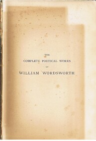 Bendigo Historical Society Inc.
Book - ALEC H CHISHOLM COLLECTION: BOOK ''THE COMPLETE POETICAL WORKS OF WILLIAM WORDSWORTH''
Book. ALEC H CHISHOLM COLLECTION. 928 page hardback book of verse by William Wordsworth with an introduction by John Morley. An engraved image of Wm. Wordsworth before the title page. Published in 1891 by MacMillan & Co. London and printed by R & R Clarke, Edinburgh. Catalogue sticker '2111 WOR' on spine. 3 newspaper cuttings inside front cover relating to Wm. Wordsworth. Sydney Morning Herald, 11/04/1970 (Bicentenary of birth), 3/06/1967 (Book review) and 3/09/1966 (Book review). Handwritten in ink inside front cover and flyleaf ''Elsa George. In loving memory of her Grandma'' ''To my ain dear Wife with loving greetings Xmas 1892 S.L.? ''. Handwritten in pencil on page 205, probably by Chisholm, ''One of Wordsworth's loveliest poems'' and also on page 248 ''Herein lies Wordsworth's charms''.William Wordsworthbooks, collections, poetry, alec h chisholm collection, william wordsworth, poetry -
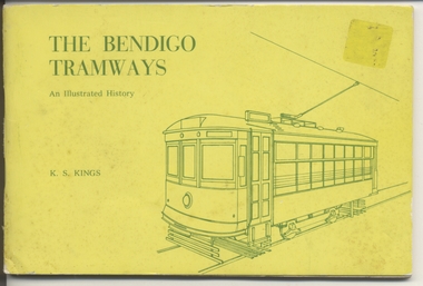 Ballarat Tramway Museum
Book, Keith Kings, "The Bendigo Tramways", Feb. 1972
Book, 80 pages, gloss art paper, in black ink with a yellow card cover in green ink, centre stapled, titled "The Bendigo Tramways" Details history of Bendigo tramways, its tramcars and the involvement of the various operators. Has maps and photographs. Written by Keith Kings and published by the Victorian Division of the Australian Railway Historical Society and others at the time of the closure of the Bendigo system. Has details of the various organisations that published the book on the rear cover. Cover, index page, maps and rollingstock lists have been scanned see jpg images i1 to i7 For book itself see pdf images i1 to i4 326.1 - ditto - purchased by W.A. Doubleday for BTM ex Scottsbluff, NE, USA 8/2003. Added 27/09/03. See Reg Item 4242 for other copies of this book which has pencil annotations.trams, tramways, bendigo, battery trams, steam trams, history -
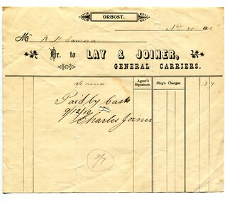 Orbost & District Historical Society
receipt docket, November 30, 1910
Mr Fred Lay, along with his father and brothers, owned the local carrier business with Mr Charlie Joiner as a business partner. They used a horse and cart to transport goods from the railway station into Orbost . In about 1907-08 Mr. Charles Joiner and Mr. Alf Lay came together and conducted a regular service — Mr. Lay at Lakes with a five horse team (because he had to travel the beach at Lake Tyers) and Mr. Joiner, at Orbost, with four horses. The two met half way and changed wagons. Asked why they did this it was said they met every boat and were at the jetty every day. This was why they cornered most of the inward loadings. (ref. River Trading on the Snowy, John Phillips) Later the business was sold to Mr David Williams. Robert Pullar Cameron was a Shire Councillor for many years. He married Penuel Hossack and had a family of James, Flora, Penuel and Alex.This item is an example of a book keeping document used by an early Orbost Business. It is a useful research item.A white receipt docket with black lines and print from Lay & Joiner, General Carriers to R. Cameron.on front - "Paid by Cash"cameron-robert-pullar lay-&-joiner-carriers transport document-receipt -
Glen Eira Historical Society
Article - ELSTER AVENUE, 18, ELSTERNWICK
This file contains 5 items about this property: 1/Handwritten notes from titles searches of 18 Elster Avenue complied by Peta Darke dated 29/07/2014 – photocopy 7 pages. 2/Handwritten list of Sands & McDougall entries for 1915 to 1970, and notes to present, compiled by Peta Darke dated 29/07/2014. 3/Photocopy of two pages of the title to the property dated 22/10/1909. Includes plan of subdivision of the area. 4/Photocopies of five advertisements from The Argus relating to the property: 28/08/1918 Land Wanted 12/07/1921 Lost Heifer 26/04/1919 Owner has House For Sale (20 Elster Avenue) 10/05/1919 same – No. 20 For Sale 29/11/1927 M. M. Taylor has Oats and Barley For Sale. 5/Photocopy of photograph of exterior taken by R. Darke circa 1998.elsternwick, gardenvale, elster avenue, robinson charles, caulfield, robinson william henry, robinson george augustus, inglis robert, davies matthew henry, ross william murray, colonial investment and agency company, victorian permanent property investment and building society, calder william anderson, watson john, rosstown junction railway and property company, kooyong road, college street, parnell (muntz) street, lempriere john thomson, thomson william hamilton, collinson william morris, elizabeth street, cumming euphemia, taylor thomas, hill caroline, evans alexander cameron, evans horace, evans gordon lemaitre, roach joyce rubena, evans mary arthur, nallo luigi, nallo joyce, north road, darke richard alexander, darke peta, peile edgar stoddart, corio, darke caroline elizabeth, darke cameron andrew, oswald street, bertram street, taylor m. m., land subdivision, architectural styles, edwardian style, brick houses, teak street, caulfield south -
Glen Eira Historical Society
Article - KOOYONG ROAD, 230, CAULFIELD NORTH, ‘SANQUHAR’
This file contains two items about this property: 1/One page of handwritten research notes, compiled by Claire Barton, about a property located at 230 Kooyong Road, Caulfield North, known as ‘Sanquhar’. Barton acquired the information therein from two sources. The first source – an article from the Argus, dated 13/06/1956, accessed via Trove on 27/08/2013, and titled ‘Old Caulfield Landmark to be Cut Up for Homes’ – notes that the property is to be subdivided into 34 individual lots. The second source – the 1923 and 1942 editions of Sands & McDougall – list the persons dwelling at the property during these years. There exists a discrepancy between these two sources. The article from the Argus implies that the property was not divided until 1956. The 1942 edition of Sands & McDougall, however, implies that it was already subdivided by this date. 2/A printout of the aforementioned article from the Argus itself, again accessed via Trove, this time on 20/06/2014.‘sanquhar’, mansions, kooyong road, glen eira road, caulfield north, barton claire, slatter kate mrs, petterson carl m., petterson e. g. miss, brown jno g., goldsack w. c., robertson j.d., cypress trees, robert harper and co. ltd., robert harper & co. ltd., abercromby & beatty pty. ltd., abercromby and beatty pty. ltd., anderson & hickling, land subdivision, bell family, bell hugh j., padey e.g., jaynes gwen, caulfield city council, anderson and hickling -
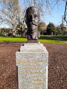 City of Ballarat
Artwork, other - Public Artwork, Wallace Anderson, Alfred Deakin (Prime Ministers' Walk) by Wallace Anderson, 1939
Alfred Deakin served three terms as Prime Minister to Australia, 1903-04,1905-08, 1909-10. The Prime Ministers Avenue is a collection of bronze bust portraits of the Prime Ministers of Australia, located at the Ballarat Botanical Gardens in Ballarat, Victoria. The Prime Ministers' portraits are commissioned after the incumbent term of each Prime Minister by the City of Ballarat. The City of Ballarat has taken responsibility for commissioning the busts after funds set aside by politician Richard Armstrong Crouch were exhausted in 2014. Crouch originally donate money to pay for six busts, the first of which was unveiled in 1940. The collection of prime ministers' busts are unique in Australia, representing the only sculptural portrait collection of all past Australian Prime Ministers. The different styles used reflect the unique artistic practices of the selected artists; textures, sizes and features and proportions are used by the artists to interpret the characteristics of each of the subjects. The artwork is of historic and aesthetic significance to the people of BallaratBronze bust cast on granite plinthAlfred Deakin Member for Ballarat Prime Minister 1903-4 1905-8 1909-10prime minister, australian pm, alfred deakin -
 Kiewa Valley Historical Society
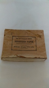
Photographs of small box originally used to contain sensitized photographic paper
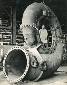
The Junction Dam and Clover Dam Power Station, stages of the Kiewa Hydro-Electric Scheme, were needed to meet the increased power demands of the wartime industry in Victoria. Clover added 26 megawatts to the grid. Junction Dam was completed and ready to hold water by September 1943, but was emptied in December 1943 and not filled again until May 1944. Construction of Clover Power Station commenced in July 1941 and both turbines were in service by May 1945.Clover Power Station and Junction Dam were part of the Kiewa Hydro Electric Scheme constructed by the State Electricity Commission of Victoria. SECV official photographers took photographs of most stages of construction of the Hydro Electric Scheme and referenced each photo with a number and dating system as an historical record and for reference for other projects. This provided a thorough history of the construction of the Hydro Electric Scheme, some of the workers involved in its construction and the infrastructure supporting its construction, such a Bogong Village.Small light brown cardboard box originally containing sensitized photographic paper, now containing a range of black and white photographs of the Kiewa Hydro Electric System taken by the official SECV photographer Box has some damage – Front panel on lid is missing. Top has a puncture in top right corner and some peeling of paper along sides and at edges. Printed on the top of the box in black ink: OPEN ONLY IN PHOTOGRAPHIC DARK ROOM SENSITIZED PAPER Manufactured by – KODAK (A/asia) PTY. LTD. Melbourne Australia Green and white sticker on right side of lid and bottom right side of box, torn at join 1. 1B1 Single Weight Soft. Available in Soft (1) Medium (2) Contrast (3) Extra Contrast (4) Single and Double Weight Stamped at bottom of sticker in grey ink G8087 CK photographic paper box; state electricity commission of victoria; official photographer; kiewa hydro electric scheme; clover power station; junction dam; bogong village -
 Kiewa Valley Historical Society
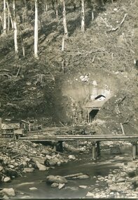
Photographs – SECV – Clover Power Station
The Junction Dam and Clover Dam Power Station, stages of the Kiewa Hydro-Electric Scheme, were needed to meet the increased power demands of the wartime industry in Victoria. Clover added 26 megawatts to the grid. Junction Dam was completed and ready to hold water by September 1943, but was emptied in December 1943 and not filled again until May 1944. Construction of Clover Power Station commenced in July 1941 and both turbines were in service by May 1945.Clover Power Station and Junction Dam were part of the Kiewa Hydro Electric Scheme constructed by the State Electricity Commission of Victoria.Set of 22 black and white photographs taken by the official SECV photographer who gave each photo a number prefixed by K (for Kiewa) K60 -no date- A bridge and entrance to tunnel K519 -no date- Welding steel lining in the tunnel K531 –no date- Construction on the Kiewa Scheme (tunnel in background K821 – no date- Bogong Village, early days K928 -15 Oct 1942- Construction Clover Power Station K947 -26 Oct 1942- Construction Clover Power Station K948 -26 Oct 1942- Construction Clover Power Station K949- 26 Oct 1942- Clover Camp in background K950 -26 Oct 1942- Construction Clover Power Station K955 -27 Oct 1942- Constructing the bridge at Clover K1102 -7 April 1943- Inlet pipe to power station K1179 –no date- Clover Power Station K1187 – no date- Clover Power Station K1189 -24 June 1943- Part of the spiral casing 1199 -7 July 1943- Clover Power Station K1201 -7 July 1943- Clover Power Station K1231 -26 July 1943- Gantry crane for Clover Power Station K1308 -6 Sept 1943- Spiral casing K1334 -6 Oct 1943- Lake Guy. Bogong Village in background K1342 -29 Oct 1943- Power station under construction K1365 -19 Nov 1943- Power station under construction K1366 -19 Nov 1943- Gantry crane for Clover Power Station On the back- each photograph has a handwritten reference number starting with K and the date stamped or written (see above)secv; kiewa hydro electric scheme; official photographer; junction dam; clover power station; bogong; -
 Kiewa Valley Historical Society
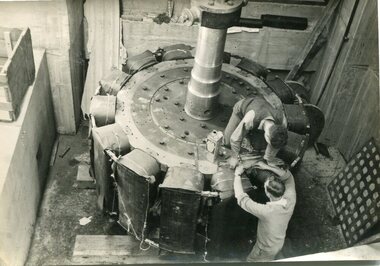
Photographs – SECV – Clover Power Station
The Junction Dam and Clover Dam Power Station, stages of the Kiewa Hydro-Electric Scheme, were needed to meet the increased power demands of the wartime industry in Victoria. Clover added 26 megawatts to the grid. Junction Dam was completed and ready to hold water by September 1943, but was emptied in December 1943 and not filled again until May 1944. Construction of Clover Power Station commenced in July 1941 and both turbines were in service by May 1945.Clover Power Station and Junction Dam were part of the Kiewa Hydro Electric Scheme constructed by the State Electricity Commission of Victoria.Set of 21 black and white photographs taken by the official SECV photographer who gave each photo a number prefixed by K (for Kiewa) K1367- 19 Nov 1943 The rotor for the generator K1368- 19 Nov 1943 Base of the generator K1377- 2 Dec 1943 Generator under construction K1380- 2 Dec 1943 Power Station under construction K1381- 2 Dec 1943 Generator being assembled K1386- 3 Dec 1943 Part of the generator K1389- 30 Dec 1943 Inlet pipe work K1391- 30 Dec 1943 Inside the power station K1392- 30 Dec 1943 Inlet pipe work K1396- 27 Jan 1944 Equipment in the power station K1410- 4 FGeb 1944 Unpacking equipment for the power station K1422- 16 Feb 1944 Generator being assembled K1425- 22 Feb 1944 Water way – power station K1433- no date Generator being assembled K1434- 3 Mar 1944 Constr5ucting the power station K1448- no date Generator inside the power station K1450- 17 Mar 1944 Clover Power station K1452- 17 Mar 1944 Looking down on the valve-water release from the power station K1456- 22 Mar 1944 ‘half Travel Opening- No 1 Relief Valve’ Overflow from the power station K1458- 22 Mar 1944 Outlet from the power station K1462- 22 Mar 1944 Inside the power station On the back- each photograph has a handwritten reference number starting with K and the date stamped or writtensecv; kiewa hydro electric scheme; clover power station; junction dam; bogong -
 Kiewa Valley Historical Society
Photographs – SECV – Clover Power Station
The Junction Dam and Clover Dam Power Station, stages of the Kiewa Hydro-Electric Scheme, were needed to meet the increased power demands of the wartime industry in Victoria. Clover added 26 megawatts to the grid. Junction Dam was completed and ready to hold water by September 1943, but was emptied in December 1943 and not filled again until May 1944. Construction of Clover Power Station commenced in July 1941 and both turbines were in service by May 1945Clover Power Station and Junction Dam were part of the Kiewa Hydro Electric Scheme constructed by the State Electricity Commission of VictoriaSet of 21 black and white photographs taken by the official SECV photographer who gave each photo a number prefixed by K (for Kiewa) K1463- 22 Mar 1944 Inside Clover Power Station K1464- 23 Mar 1944 Valve K1466- 23 Mar 1944 Fittings for the power station K1467- 23 Mar 1944 Valve K1472- 30 Mar 1944 Equipment being installed in Clover Power Station K1474- 31 Mar 1944 Equipment for the power station K1493- 19 April 1944 Transformer K1495- 28 April 1944 Part of the generator being installed K1514- 11 May 1944 Equipment in the power station K1563- 9 June 1944 Turbine under construction K1565- 22 June 1944 Shaft between turbine and generator K1567- 22 June 1944 Turbine in the power station K1568- 22 June 1944 Transformers K1570- 5 June 1944 Guide vane actuators K1574- 22 June 1944 Equipment in the power station K1567- 22 June 1944 Clover Power Station K1607- 14 Aug 1944 Equipment in the power station K1620- 27 Aug 1944 ‘Charles Tavare (?) Equipment in the power station K1626- 23 Aug 1944 Clover Power Station K1628- 23 Aug 1944 Clover Power Station K1629- 23 Aug 1944 Clover Power Station On the back- each photograph has a handwritten reference number starting with K and the date stamped or writtensecv; kiewa hydro electric scheme; clover power station; junction dam; bogong -
 Kiewa Valley Historical Society
Photographs – SECV– Clover Power Station
The Junction Dam and Clover Dam Power Station, stages of the Kiewa Hydro-Electric Scheme, were needed to meet the increased power demands of the wartime industry in Victoria. Clover added 26 megawatts to the grid. Junction Dam was completed and ready to hold water by September 1943, but was emptied in December 1943 and not filled again until May 1944. Construction of Clover Power Station commenced in July 1941 and both turbines were in service by May 1945.Clover Power Station and Junction Dam were part of the Kiewa Hydro Electric Scheme constructed by the State Electricity Commission of Victoria.Set of 2 large black and white photographs of spiral casing for a turbine being transported to a power station on the Kiewa Scheme. Gentleman in lab coat standing inside casing in photograph 1 On the back – dark grey ink stamp “Photographed by / E.B. Studios / 309 George St., / Tel. SW 7373 Sydney” clover power station, secv -
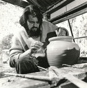 Eltham District Historical Society Inc
Photograph, Peter Laycock, 1971ca
Page 133: "..Studio potters and ceramic artists began settling in this area (Warrandyte) from about 1945.. Meanwhile a group was developing at Cottles Bridge, making their own kick-wheels and kilns and producing pots and models by what often began as a co-operative system, two or more artists co-operating in making each article... Husband and wife teams predominated.. Laycock and Alma Shanahan have been responsible for the now thriving reputation of the "Dunmoochin" pottery.."Black and white photograph reproduced on p131 of 'Pioneers & Painters: One Hundred years of Eltham and its Shire' by Alan Marshall (1971)pioneers and painters, peter laycock, dunmoochin, pottery -
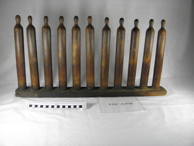 Richmond & Burnley Historical Society
Condom Mould
This wooden condom former has no defined manufacture date and was used in the production of rubber condoms in Melbourne by the rubber goods manufacturer Ansell. Wooden formers of this type were used from 1905 till 1945. The condom former would be dipped tip first into liquid rubber and the covering left to dry, and then the resulting condom packaged and sold. This object was acquired by the Richmond and Burnley Historical Society in the 1970’s on the closing of the Ansell factory located on River St, Richmond. This object has historical significance at a national level, as it is associated with the use and manufacture of sexual health devices within the broader Australian context. It also holds local historical significance as a marker of local manufacturing and industry in Victoria. Alongside these points it is also a large part of the story that surrounds the creation of Ansell Industries as we know them in a modern context. Wooden condom former/ mold. Frame consists of 11 individual upright moulds. Used by the Ansell Rubber Co. Pty Ltd in the production of condoms. Obtained in 1970's from an old factory site occupied by Ansell. None visibleansell, condom machinery, richmond industry, moulds, rubber products, sexual health, contraception, condom -
Tatura Irrigation & Wartime Camps Museum
Photograph, Decker and Stuerzenhofecker Graves, 1989 copied
This is believed to be the Stuerzenhofecker family who lived in Camp 3. This family lost 2 children whilst in the camp. The first accident occurred when their 2 year old boy, Hartmann (born 11 November 1944), was accidentally run over and killed by an Army truck on the 24 October 1946.A month later their 14 month old daughter, Heimtraut (born 19 September 1945), died of smoke inhalation in a hut fire on the 17 November 1946.Black and white photo of grave sites. Two grave stone crosses with the words "J. Decker" on one and "H. Stuerzenhofecker" on the other. 3 children, 2 girls and a boy are standing in front of a man and woman. All are standing at the head of the graves.J. Decker H. Stuerzenhofeckerdecker, stuerzenhofecker, internment camp 3, internment camp graves