Showing 5386 items
matching a field
-
 Ringwood and District Historical Society
Booklet - Newsletter, Warrandyte Historical Society Inc. - The First Gold Field in Victoria - How l discovered it, by Louis John Michel, 1896
Personal recollections of Louis John Michel after the events which he described in The Argus on Saturday 28 December 1895 -
 Orbost & District Historical Society
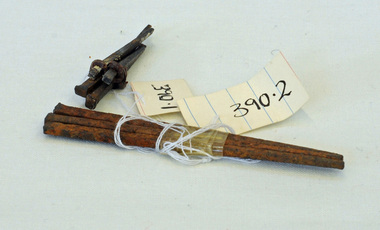
nails, 1890's
These hand-made nails were used in what was Temple's Store built in 1889. It later became Herbert's - now demolished and is the present site of the Foodworks Supermarket.Temple's store was on the corner of Ruskin Street and Nicholson Street. George Temple (1832-1918) established the store in about 1888. He packed stores to the Bendoc area gold fields.Two lots of hand-made nails. .1 is a set of five small nails tied together with string. .2 is a set of three longer nails which are very rusty.nails metal-working temples-store -
 Australian Commando Association - Victoria
Equipment - Field dressing
-
 Ringwood and District Historical Society
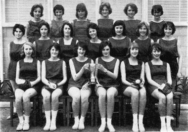
Photograph - Group, Ringwood Technical School 1962 Girls Softball Field Day Team, c 1962
Black and White Photographrts, ringwood tech -
 Orbost & District Historical Society
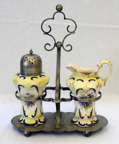
cruet set, 1913-1917
This cruet set reflects the style of tableware produced in Staffordshire, England, in the early 20th century. Staffordshire became the centre of pottery manufacture in England by 1730, and a century later it was established as an international centre, exporting its products around the world. Staffordshire pottery was widely used in homes and cafes throughout Australia.A cruet set on a silver plated stand. The jug and shaker are ceramic - violets on a cream background.The shaker has a silver-plated topBase of jug- S.F. & G. Stoke on Trent England ; a crown ; Crown Division Shaker - on lid -E.P.N.S. and on the base - S.F. & G. Stoke on Trent England ; a crown ; Crown Divisionporcelain pottery cruet-set fielding -
 Flagstaff Hill Maritime Museum and Village
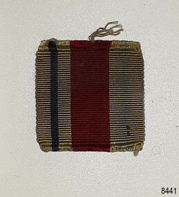
Badge - Insignia Ribbon, 1939-1945
The cloth insignia patch is one of a collection of military badges that date to the World War II period. This ribbon has not yet been identified. The badges are now part of Flagstaff Hill’s comprehensive W.R. Angus Collection, donated by the family of Dr W R Angus (1901-1970), surgeon and oculist. Dr W R Angus was a Surgeon Captain for the Australian Defence Forces, Army Medical Corps, stationed in Ballarat, Victoria, and in Bonegilla, N.S.W. He completed his service just before the end of the war due to suffering from a heart attack. The W.R. Angus Collection: - The W.R. Angus Collection includes historical medical equipment, surgical instruments and material belonging to Dr Edward Ryan and Dr Thomas Francis Ryan, (both of Nhill, Victoria) and Dr Angus’ own belongings. The Collection’s history spans the medical practices of the two Doctors Ryan, from 1885-1926 plus that of Dr Angus, up until 1969. It includes historical medical and surgical equipment and instruments from the doctors Edward and Thomas Ryan of Nhill, Victoria. Dr Angus married Gladys in 1927 at Ballarat, the nearest big city to Nhill where he began as a Medical Assistant. He was also Acting House surgeon at the Nhill hospital where their two daughters were born. During World War II He served as a Military Doctor in the Australian Defence Forces. Dr Angus and his family moved to Warrnambool in 1939, where Dr Angus operated his own medical practice. He later added the part-time Port Medical Officer responsibility and was the last person appointed to that position. Both Dr Angus and his wife were very involved in the local community, including the planning stages of the new Flagstaff Hill and the layout of the gardens there. Dr Angus passed away in March 1970.This insignia ribbon is connected to the collection of military badges in the W.R. Angus Collection. Dr W R Angus (1901-1970), surgeon and oculist, collected a range of military objects including those he personally used during his time as Surgeon Captain in the Australian Defence Forces in World War II. The item allows insight into military life in the early-to-mid 20th century. The W.R. Angus Collection is significant for still being located at the site it is connected with, Doctor Angus being the last Port Medical Officer in Warrnambool. The Collection includes historical medical objects that date back to the late 1800s.Badge, woven ribbon insignia patch. Rectangular patch has vertical stripes, one is a narrow blue stripe and the other is a wide red or crimson stripe. The cloth patches belonged to Dr W R Angus and are now part of the W. R. Angus Collection.flagstaff hill, warrnambool, maritime village, maritime museum, shipwreck coast, great ocean road, flagstaff hill maritime museum and village, dr w r angus, w.r. angus collection, australian army, surgeon captain, ballarat, bonegilla, badge, insignia, badge collection, world war 2, second world war, australian defence forces, army medical corps, military uniform, cloth patch, insignia patch, australian army medical corp (militia), ww 2, ww ii, 1925-1940, military badge, non-divisional unit, aamc, 1940-1942, 8th field ambulance, peacetime training, insignia history, insignia ribbon, ribbon patch -
 Flagstaff Hill Maritime Museum and Village
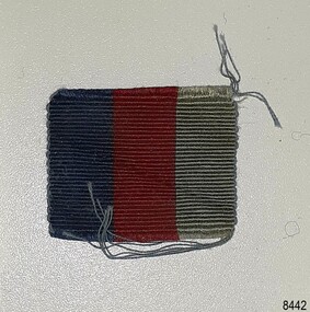
Badge - Insignia Ribbon, 1939-1945
The cloth insignia patch is one of a collection of military badges that date to the World War II period. This ribbon has not yet been identified. The badges are now part of Flagstaff Hill’s comprehensive W.R. Angus Collection, donated by the family of Dr W R Angus (1901-1970), surgeon and oculist. Dr W R Angus was a Surgeon Captain for the Australian Defence Forces, Army Medical Corps, stationed in Ballarat, Victoria, and in Bonegilla, N.S.W. He completed his service just before the end of the war due to suffering from a heart attack. The W.R. Angus Collection: - The W.R. Angus Collection includes historical medical equipment, surgical instruments and material belonging to Dr Edward Ryan and Dr Thomas Francis Ryan, (both of Nhill, Victoria) and Dr Angus’ own belongings. The Collection’s history spans the medical practices of the two Doctors Ryan, from 1885-1926 plus that of Dr Angus, up until 1969. It includes historical medical and surgical equipment and instruments from the doctors Edward and Thomas Ryan of Nhill, Victoria. Dr Angus married Gladys in 1927 at Ballarat, the nearest big city to Nhill where he began as a Medical Assistant. He was also Acting House surgeon at the Nhill hospital where their two daughters were born. During World War II He served as a Military Doctor in the Australian Defence Forces. Dr Angus and his family moved to Warrnambool in 1939, where Dr Angus operated his own medical practice. He later added the part-time Port Medical Officer responsibility and was the last person appointed to that position. Both Dr Angus and his wife were very involved in the local community, including the planning stages of the new Flagstaff Hill and the layout of the gardens there. Dr Angus passed away in March 1970.This insignia ribbon is connected to the collection of military badges in the W.R. Angus Collection. Dr W R Angus (1901-1970), surgeon and oculist, collected a range of military objects including those he personally used during his time as Surgeon Captain in the Australian Defence Forces in World War II. The item allows insight into military life in the early-to-mid 20th century. The W.R. Angus Collection is significant for still being located at the site it is connected with, Doctor Angus being the last Port Medical Officer in Warrnambool. The Collection includes historical medical objects that date back to the late 1800s.Badge, woven ribbon insignia patch. Rectangular patch has wide vertical stripes, one is a blue stripe and the other is a red or crimson stripe. The cloth patches belonged to Dr W R Angus and are now part of the W. R. Angus Collection.flagstaff hill, warrnambool, maritime village, maritime museum, shipwreck coast, great ocean road, flagstaff hill maritime museum and village, dr w r angus, w.r. angus collection, australian army, surgeon captain, ballarat, bonegilla, badge, insignia, badge collection, world war 2, second world war, australian defence forces, army medical corps, military uniform, cloth patch, insignia patch, australian army medical corp (militia), ww 2, ww ii, 1925-1940, military badge, non-divisional unit, aamc, 1940-1942, 8th field ambulance, peacetime training, insignia history, insignia ribbon, ribbon patch -
Marysville & District Historical Society
Document (item) - Report, Clement Wilks, Track to the River Jordan Gold Fields, 1864-1865
A report by Mr Road Engineer Wilks on the construction of the Yarra Track in Victoria.A report by Mr Road Engineer Wilks on the construction of the Yarra Track in Victoria. The Yarra Track is the former name of the gold fields road from Healesville to the Woods Point and Jordan Goldfields, in Victoria, Australia. By Authority: JOHN FERRES, Government Printer, Melbourneclement wilks, yarra track, marysville, victoria, wood's point, healesville, jordan gold fields -
 Marysville & District Historical Society
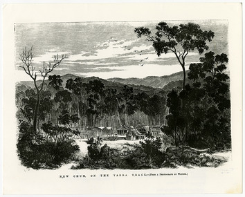
Work on paper (item) - Print of wood engraving, Frederick Grosse et al, New Chum on the Yarra Track, 27-09-1866
A copy of an early wood engraving taken from a photograph of the deserted township of New Chum, near Healesville, on the Yarra Track in Victoria.A copy of an early wood engraving taken from a photograph of the deserted township of New Chum, near Healesville, on the Yarra Track in Victoria. The Yarra Track is the former name of the gold fields road from Healesville to the Woods Point and Jordan Goldfields in Victoria.new chum, healesville, yarra track, victoria, frederick grosse, albert charles cooke, thomas waters, wood engraving -
 Marysville & District Historical Society
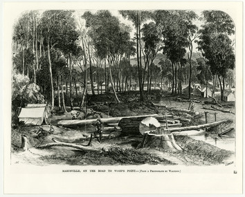
Work on paper (item) - Print of wood engraving, Frederick Grosse et al, Marysville, on the road to Wood's Point, 27-11-1866
A copy of an early wood engraving taken from a photograph of the township of Marysville in Victoria.A copy of an early wood engraving taken from a photograph of the township of Marysville in Victoria. The Yarra Track is the former name of the gold fields road from Healesville to the Woods Point and Jordan Goldfields in Victoria.victoria, frederick grosse, albert charles cooke, thomas waters, wood engraving, marysville, wood's point road -
 Marysville & District Historical Society
Photograph (Item) - Black and white photograph, Yarra Track Hotel, c1900
An early black and white photograph of a hotel along the Yarra Track.An early black and white photograph of a hotel along the Yarra Track. The Yarra Track is the former name of the gold fields road from Healesville to the Woods Point and Jordan Goldfields, in Victoria, Australia. A direct route via the Yarra River and the Great Divide was discovered by Rieck in September 1862 and became known as the Yarra Track. Early in 1863, the Victorian Government decided to construct a 193-kilometre (120 mile) road along the route. Its original width varied between 4 and 6 metres (12 and 20 feet), and was designed to accommodate horse-drawn vehicles. The Track involved the climbing of the Black Spur, descent into the Acheron Valley, and then through Marysville to the Cumberland where it followed the existing route. Unable to ascertain both the location and name of hotel.ARMSTRONG COLLECTION 42 STATION STREET/ SANDRINGHAM 3191/ TEL. (03) 9521 5442/ IAN M.L. ARMSTRONG OAMyarra track, healesville, wood's point, jordan goldfields, victoria, yarra river, great divide, reick, black spur, acheron valley, marysville, cumberland creek -
 Marysville & District Historical Society
Photograph (Item) - Black and white photograph, The "Scandinavians' - (Deserted), c1900
An early black and white photograph of The Scandinavian's Hotel and Boarding House along the Yarra Track.An early black and white photograph of The Scandinavian's Hotel and Boarding House along the Yarra Track. The Yarra Track is the former name of the gold fields road from Healesville to the Woods Point and Jordan Goldfields, in Victoria, Australia. A direct route via the Yarra River and the Great Divide was discovered by Rieck in September 1862 and became known as the Yarra Track. Early in 1863, the Victorian Government decided to construct a 193-kilometre (120 mile) road along the route. Its original width varied between 4 and 6 metres (12 and 20 feet), and was designed to accommodate horse-drawn vehicles. The Track involved the climbing of the Black Spur, descent into the Acheron Valley, and then through Marysville to the Cumberland where it followed the existing route.ARMSTRONG COLLECTION 42 STATION STREET/ SANDRINGHAM 3191/ TEL. (03) 9521 5442/ IAN M.L. ARMSTRONG OAMthe scandinavians', yarra track, healesville, wood's point, jordan goldfields, victoria, yarra river, great divide, reick, black spur, acheron valley, marysville, cumberland creek -
 Marysville & District Historical Society
Photograph (Item) - Black and white photograph, Camp Opposite The "Scandinavians', c1900
An early black and white photograph of a camp which was opposite The Scandinavian's Hotel and Boarding House along the Yarra Track.An early black and white photograph of a camp which was opposite The Scandinavian's Hotel and Boarding House along the Yarra Track. The Yarra Track is the former name of the gold fields road from Healesville to the Woods Point and Jordan Goldfields, in Victoria, Australia. A direct route via the Yarra River and the Great Divide was discovered by Rieck in September 1862 and became known as the Yarra Track. Early in 1863, the Victorian Government decided to construct a 193-kilometre (120 mile) road along the route. Its original width varied between 4 and 6 metres (12 and 20 feet), and was designed to accommodate horse-drawn vehicles. The Track involved the climbing of the Black Spur, descent into the Acheron Valley, and then through Marysville to the Cumberland where it followed the existing route.ARMSTRONG COLLECTION 42 STATION STREET/ SANDRINGHAM 3191/ TEL. (03) 9521 5442/ IAN M.L. ARMSTRONG OAMthe scandinavians', yarra track, healesville, wood's point, jordan goldfields, victoria, yarra river, great divide, reick, black spur, acheron valley, marysville, cumberland creek -
Marysville & District Historical Society
Document (Item) - Research Document, Judith Vimpani, William Cavanagh Farrell (1844-1901), 04-2020
An account of the life of William Cavanagh Farrell.An account of the life of William Cavanagh Farrell who was important to Marysville as his review in 1863 of the routes to Wood's Point led to the Yarra Track ascending the Black Spur and going on to what became the resort town of Marysville on the Steavenson River. The Yarra Track is the former name of the gold fields road from Healesville to the Woods Point and Jordan Goldfields, in Victoria, Australia. A direct route via the Yarra River and the Great Divide was discovered by Reick in September 1862 and became known as the Yarra Track. Early in 1863, the Victorian Government decided to construct a 193-kilometre (120 mile) road along the route. Its original width varied between 4 and 6 metres (12 and 20 feet), and was designed to accommodate horse-drawn vehicles. The Track involved the climbing of the Black Spur, descent into the Acheron Valley, and then through Marysville to the Cumberland where it followed the existing route.willaim cavanagh farrell, marysville, victoria, wood's point, yarra track, black spur, steavenson's creek, steavenson river, george theodore rieck -
Marysville & District Historical Society
Document (Item) - Research Document, Judith Vimpani, George Theodore Rieck (1833-pos 1884), 04-2020
An account of the life of George Theodore Rieck.An account of the life of George Theodore Rieck. The Yarra Track is the former name of the gold fields road from Healesville to the Woods Point and Jordan Goldfields, in Victoria, Australia. A direct route via the Yarra River and the Great Divide was discovered by Rieck in September 1862 and became known as the Yarra Track. Early in 1863, the Victorian Government decided to construct a 193 kilometre (120 mile) road along the route. Its original width varied between 4 and 6 metres (12 and 20 feet), and was designed to accommodate horse-drawn vehicles. The Track involved the climbing of the Black Spur, descent into the Acheron Valley, and then through Marysville to the Cumberland where it followed the existing route.george theordore rieck, marysville, victoria, james murphy, new chum creek, wood's point, gold mining, matlock, walhalla, yarra track -
Marysville & District Historical Society
Booklet (Item) - Information booklet, Artworkz Tourism, The Big Culvert, Unknown
An information booklet that was produced as a guide to The Big Culvert.An information booklet that was produced as a guide to The Big Culvert. The Big Culvert is a historic granite and bluestone arch along the Yarra Track, a major route to Melbourne through the 1800s. Built in 1870 and a major piece of infrastructure for its time, the heritage listed culvert allowed water to flow under often-flooded the road. The Yarra Track is the former name of the gold fields road from Healesville to the Woods Point and Jordan Goldfields, in Victoria, Australia. A direct route via the Yarra River and the Great Divide was discovered by Rieck in September 1862 and became known as the Yarra Track. Early in 1863, the Victorian Government decided to construct a 193-kilometre (120 mile) road along the route. Its original width varied between 4 and 6 metres (12 and 20 feet), and was designed to accommodate horse-drawn vehicles. The Track involved the climbing of the Black Spur, descent into the Acheron Valley, and then through Marysville to the Cumberland where it followed the existing route.the big culvert, yarra track, victoria, healesville, wood's point goldfields, jordan goldfields, black spur, acheron valley, cumberland valley -
Marysville & District Historical Society
Flyer (Item) - Information flyer, Artworkz Tourism, The Big Culvert, 26-03-2016
An information flyer that was produced as a guide to The Big Culvert.An information flyer that was produced as a guide to The Big Culvert. The Big Culvert is a historic granite and bluestone arch along the Yarra Track, a major route to Melbourne through the 1800s. Built in 1870 and a major piece of infrastructure for its time, the heritage listed culvert allowed water to flow under often-flooded the road. The Yarra Track is the former name of the gold fields road from Healesville to the Woods Point and Jordan Goldfields, in Victoria, Australia. A direct route via the Yarra River and the Great Divide was discovered by Rieck in September 1862 and became known as the Yarra Track. Early in 1863, the Victorian Government decided to construct a 193-kilometre (120 mile) road along the route. Its original width varied between 4 and 6 metres (12 and 20 feet), and was designed to accommodate horse-drawn vehicles. The Track involved the climbing of the Black Spur, descent into the Acheron Valley, and then through Marysville to the Cumberland where it followed the existing route.the big culvert, yarra track, victoria, healesville, wood's point goldfields, jordan goldfields, black spur, acheron valley, cumberland valley -
 Marysville & District Historical Society
Photograph (Item) - Black and white photograph, Unknown
A black and white photograph taken at the unveiling of the sign placed at The Big Culvert.A black and white photograph taken at the unveiling of the sign placed at The Big Culvert. The Big Culvert is a historic granite and bluestone arch along the Yarra Track, a major route to Melbourne through the 1800s. Built in 1870 and a major piece of infrastructure for its time, the heritage listed culvert allowed water to flow under often-flooded the road. The Yarra Track is the former name of the gold fields road from Healesville to the Woods Point and Jordan Goldfields, in Victoria, Australia. A direct route via the Yarra River and the Great Divide was discovered by Rieck in September 1862 and became known as the Yarra Track. Early in 1863, the Victorian Government decided to construct a 193-kilometre (120 mile) road along the route. Its original width varied between 4 and 6 metres (12 and 20 feet), and was designed to accommodate horse-drawn vehicles. The Track involved the climbing of the Black Spur, descent into the Acheron Valley, and then through Marysville to the Cumberland where it followed the existing route.Unveiling of sign/ at "Big Culvert" In front Max Cockerrell and - Rear: second back Geoff Pope R.H.S. rear: Nancy "/ Anne "the big culvert, yarra track, victoria, healesville, wood's point goldfields, jordan goldfields, black spur, acheron valley, cumberland valley -
 Marysville & District Historical Society
Photograph (Item) - Colour photograph, 20-09-2008
A colour photograph of the entrance to The Big Culvert.A colour photograph of the entrance to The Big Culvert. The Big Culvert is a historic granite and bluestone arch along the Yarra Track, a major route to Melbourne through the 1800s. Built in 1870 and a major piece of infrastructure for its time, the heritage listed culvert allowed water to flow under often-flooded the road. The Yarra Track is the former name of the gold fields road from Healesville to the Woods Point and Jordan Goldfields, in Victoria, Australia. A direct route via the Yarra River and the Great Divide was discovered by Rieck in September 1862 and became known as the Yarra Track. Early in 1863, the Victorian Government decided to construct a 193-kilometre (120 mile) road along the route. Its original width varied between 4 and 6 metres (12 and 20 feet), and was designed to accommodate horse-drawn vehicles. The Track involved the climbing of the Black Spur, descent into the Acheron Valley, and then through Marysville to the Cumberland where it followed the existing route.the big culvert, yarra track, victoria, healesville, wood's point goldfields, jordan goldfields, black spur, acheron valley, cumberland valley -
 Federation University Historical Collection
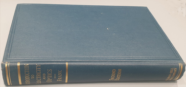
Book, Nathaniel Frank, Introduction to Electricity and Optics, 1950
Dark Blue synthetic hard caver book of 440 pages with gold lettering embossed on the spine. non-fictionelectricity, optics, force, electrostatic, charg and capacity, electric currents, magnetic field, alternating current circuits, electromagnetic waves, radiation, conduction, dielectrics, geometrical optics, interference, heat radiation, diffraction -
Glen Eira Historical Society
Document - CAULFIELD CITY CHOIR
This file contains five items: 1/A program of the ‘Second Folk Song Festival’ presented by Caulfield City Choir conducted by David Plummer. Date unknown. 2/Three musical score sheets transcribed by Michael Finnissy for the Caulfield City Choir, dated 1983. 3/A black and white program for the Caulfield City Choir’s Christmas Celebrations at St. John’s Uniting Church on 06/12/1986, conducted by Douglas Heywood. 4/Two black and white programs of presentations given by the Caulfield City Choir and the Camberwell Chorale with the Camerata Orchestra, conducted by Douglas Heywood, at the Camberwell Centre. The first is of the Verdi Requiem on 03/05/1987; the second is ‘The Creation’ by Joseph Haydn on 14/05/1988. 5/A black and white program of the Caulfield City Choir Inc.’s presentation of Victorian Lollipops, conducted by Douglas Heywood at St. Stephen’s Uniting Church Hall on 13/09/1987.emms betty miss, kooyong road, caulfield, caulfield city choir, plummer david, law bernard, butler eric, finnissy michael, murrumbeena, harries rita, st. john’s uniting church, glenhuntly road, glen huntly road, elsternwick, hopetown gardens, heywood douglas, shewan joan, st. margaret’s anglican church caulfield, baptist church murrumbeena, church of christ carnegie, st. james’ lutheran church moorabbin, st. andrew’s presbyterian church caulfield south, holy cross roman catholic church caulfield south, st. john’s uniting church elsternwick, baker tim, sneddon j.f. mrs., snowdon avenue, caulfield city council, caulfield philharmonic society, sneddon marjorie, snedden marjorie, north road, ormond, barnard j., cook d., copley m., duncan d., field b., ford r., fraser g., granger t., greenhaugh h., howells c., jefferies c., kuca m., lockett j., mcalpine c., mcconchie c., mealy m., moorees j., nicholas n., nixon v., polites s., pope m., port m., provelsen m., provelson m., rose r., simmons h., terkuile k., alcock j., bannister j., barnett m., beeson b., cinaglia c., glasson m., griffon b., holmes w., sneddon m., weickhardt j., henderson v., ingram h., ketels m., nutt a., polites c., warden n., dobbin l., mccaffrey p., newbold r., prebble r, shewan j., st. stephen’s uniting church hall, balaclava road, hawthorn road, kooyong road, dobbin leo, heywood thomas, ford dellys, the scotsglen players, caulfield city hall, glen eira road, new city hall, st. stephen’s uniting church, glasson m. mrs, new caulfield city hall, nicholas n. miss, quaife merlyn, ashton-smith david, lukey desmond, reither charles, caulfield town hall, hirst susan, anderson peter, town halls, orchestras, music, people associated with culture, singers, choirs, official buildings, uniting church, festivals and celebrations, musical events and activities, cultural events and activities, musicians, conductors (music), operas, religious festivals, christmas, official buildings, clubs and associations -
Glen Eira Historical Society
Article - LONG, JOHN
This file contains two items: 1/A photocopied carbon copy detailing Robert Marriott and John Long from their arrival in Victoria. It notes that both became councillors in the City of St. Kilda and where they lived. 2/Photocopied photo from ‘Sand, Swamp and Heath’ of Caulfield Borough Council, 1901. Includes John Long, page 24.marriott robert, long john, gold, caulfield, councillors, st. kilda, hawthorn road, alexander hospital, hospitals, flowers street, laura street, glenhuntly road, marriott john, bambra road, field street -
Glen Eira Historical Society
Letter - MARRIOTT FAMILY
This file contains three items of this family’s correspondence 1/A Carbon copy page giving details of Robert and John Marriott and John Long, from their arrival in Victoria. Includes brief history of their lives becoming councillors for the city of Caulfield. Also Robert’s early market garden business in the area, and how he established Camden Town Methodist Church. 2/A handwritten letter to Mr. Murray from Catherine Marriott dated 29th Oct (no year) 3/A Two handwritten pages of working notes in Peter Murray’s writing, author for ‘Sand, Swamp and Heath’.marriot robert, long john, gold, caulfield, councillors, st. kilda, hawthorn road, alexandra hospital, hospitals, flowers street, laura street, glen huntly road, marriot john, bambra road, field street, goe street, market gardeners, bentleigh, marriott thomas, methodist church, sunday schools, camden, hawthorn road, indoor bowling club, sporting clubs, lewis bobby, jockeys, marriott catherine, marriott arthur, hughes d, blanche mrs., stables, kooyong road, ricketson h, mallinson j, kunney m, evans john, grange road, millar w, nyora road, rate book -
Glen Eira Historical Society
Document - COATESVILLE UNTING CHURCH CORNER NORTH AND MACKIE ROAD
Two items about this church: 1/Photocopied details of the Church’s preliminary stages of development at Coatesville Uniting Church. 2/Photocopied article with brief details of Coatesville parish history which includes East Bentleigh Presbyterian and South Oakleigh Methodist parishes.south oakleigh methodist church, reid a, north road, coatesville uniting church, bray mr, mackie road, harris mr, phillips l.g. rev, okey mr, adams mr, williams w.j. rev, murrumbeena, harris mr, iliffe w.r, hallibone mr, fielding mr, reynolds mr, nancarraw mr, reic a mr, thomas miss, winter mr, lanym a. mr, sturgess h mr, sturgess mrs, duncan annie, duncan gordon, sturgess edith, evans chas, ralton mr, architects, coatesville parish, uniting church, east bentleigh presbyterian church, cecil street, peerman alex rev, east bentleigh presbyterian, market gardens, st christopher’s church, bell a.f. rev, body alan rev, jassa street, manses, trevorrow mr, halls, sunday schools, bentleigh east -
Glen Eira Historical Society
Document - Glen Eira Residents Association
Six items pertaining to Glen Eira Residents Asssociation Inc. 1/Two copies of the minutes of a Committee Meeting of Glen Eira Residents Association Inc., held on 04/12/2001. The minutes cover a range of routine meeting items, as well as the postponed release of the Princes Park Master Plans and the proposed construction of car parks at Caulfield Racecourse. 2/A copy of Glen Eira Residents’ Association Inc.’s 30/05/2003 newsletter, notifying members of matters presently before Glen Eira City Council for purposes of evaluation. Matters include an admonishment to the Council to sort out anomalies between the C25 Amendment (80/20 Plan) and the Melbourne 2030 Plan, the success at convincing the Ministerial panel to adopt GERA’s views regarding the C14 Council Plan for the Caulfield Racecourse, a request for information from the Council regarding the previous year’s rate increase, a request for information from the Council regarding spending on planning for improvements to Princes Park, a call for the Council to improve its consultative procedures, a recommendation that the purpose of Glen Eira News be expanded to the making of suggestions for city improvement, and a notification of the measures implemented to improve the visibility of Caulfield Racecourse’s usability by the public. Includes a black-and-white photograph of Orrong Road, Elsternwick, illustrating what Glen Eira’s roads would look like if lined with trees, which was excluded from Glen Eira News on account of a current prohibition on the making of suggestions for city improvements. 3/Four copies of a booklet entitled ‘A Short Guide to Planning Procedures’, composed 08/2006, which endeavours to explain, as concisely as possible, the methodology by which Glen Eira City Council approves real estate developments and issues planning permits. 4/A booklet containing the minutes of the 05/10/2009 Annual General Meeting of Glen Eira Residents’ Association Inc. Details both routine items and more specific matters of discussion, such as inappropriate charges on the part of the Glen Eira City Council and the proposed inception of a questionnaire to evaluate local residents’ opinion of the Council. 5/A booklet announcing the 07/10/2010 Annual General Meeting of Glen Eira Residents’ Association Inc. at St. John’s Uniting Church, Elsternwick. Front cover details agenda and contains four colour photographs pertaining to public transport (buses, trams, trains) within the city. Interior features president Don Dunstan reflecting on issues relevant to GERA occurring over the preceding twelve months, with an emphasis on the dubious behaviour of the City Council, as well as two colour photographs: one of Dunstan himself and one of traffic at Elsternwick Junction. The rear cover contains the Financial Statement presented to the Meeting. 6Two copies of a printout of an article from the website of Glen Eira Residents’ Association Inc., accessed 19/06/2012, explaining the affects wrought as a result of the implementation of Planning Scheme Amendment C87. Said amendment changes the Planning Scheme protecting neighbourhood character by replacing the previous Significant Character Area (SCA) designation with the new designations of Neighbourhood Character Overlay (NCO) and Design and Development Overlay (DDO). In developing the Amendment, Glen Eira City Council commissioned Planisphere to procure the Planisphere Final Report, in which recommendations regarding the expansion, creation and deletion of SCAs were offered. The article contains a summary of said recommendations.glen eira residents’ association inc., clubs and associations, glen eira, meetings, minutes, campbell jack, dunstan don, marwick geoff, pleydell max, teseriero dominic, robins kevin, princes park, south caulfield, glen eira city council, local government, councillors, brennan martin, victorian local government association (vlga), erlich mayor, project manikato, caulfield racecourse, caulfield racecourse flat, racecourses, parks, car parks, kennedy cr., kennedy norman mr., crown land, glen eira road, rippon lea, c25 plan (80/20), melbourne 2030 plan, c14 council plan, rates, orrong road, elsternwick, trees, station street, caulfield north, neerim road, glenhuntly, glenhuntly park, orrong ward, grossbard cr., martens cr., building permits, delegated planning committee (dpc), steward joy, brohier peter, campbell fliss, scutt alex, ray darren, hannah brian, st. john’s uniting church, mees paul dr., elsternwick club, sandham street, melbourne weekly bayside, glen eira debates, walsh investigation, whelen investigation, forge cheryl cr., whiteside helen mayor, save our suburbs (sos), walsh mary, walsh kevin, french christine, elsternwick junction, planning scheme, planning scheme amendment c87, significant character areas (scas), planisphere final report, oakdene crescent, carnegie, blackwood street, housing diversity areas, urandaline grove, caulfield, normanby road/park crescent, kambrook road, balaclava road, hawthorn road tramway estate, caulfield south, ulupna road, ormond, murray street, prentice street, kambea grove, chestnut street, mcpherson avenue, queens avenue, caulfield east, derby crescent, clarinda street, st. james parade/downshire road, exhibition street, mckinnon, field street, boyd park, murrumbeena, lindsay avenue, lydson street -
Glen Eira Historical Society
Article - Caulfield South Bowling Club
This file contains eleven items. Caulfield Bowling Club cashbook 1993-1998. Caulfield South Bowling Club Foundation Opening day programme dated 11/09/1948 in Princes Park, Caulfield South. Caulfield South Bowling Club Opening day programme dated 27/08/1949. Caulfield South Bowling Club Sixth Opening day programme dated 05/09/1953. Caulfield South Bowling Club Seventh Opening day programme dated 04/09/1954. Caulfield South Bowling Club Eighth Opening day programme dated 10/09/1955. Caulfield South Bowling Club Annual Report dated 1950-1951. An article from the Caulfield Port Phillip Leader detailing the Battle of the Bowls event that was held to raise money for the Bowls Disaster Relief Fund dated 12/04/2011. An article from the Melbourne Weekly Bayside on the use of Caulfield Racecourse dated 04/05/2011. Esternwick District Bowling Club and Elsternwick District Ladies Bowlng Club invitation for the combined official opening of the Green Ceremony for the 75th Anniversary of the clubs’ opening, dated 31/08/1984. An article from the Caulfield Leader on the demolition of two Melbourne Racing Club buildings in Glen Eira, dated 05/07/2011.miller elizabeth, southwick david, dodds d.a., norris c.e., gainey j., parton e.m., morris t.w., caulfield, victorian bowling association, sims howard, caulfield south ladies bowls, caulfield south bowling club, joske p.e., caulfield park, caulfield junior citizens band, bowls disaster relief fund, mckinnon, glen eira, elsternwick, murrumbeena park, penhalluriack frank, caulfield racecourse, carnegie, supporters of caulfield reserve, caulfield village, battle of the bowls, pennant competition, house committee, station street, caulfield north, caulfield north tabaret, booran road, caulfield south, glen eira road, dover street, don john, crown land, clubs, associations, societies, sports, recreations, leisure, cultural events, bowling clubs, sports establishments, recreations establishments, cultural structures, sports grounds, playing fields, parks, reserves, sports people, r.b.v.a., caulfield port phillip leader, nation robert, nation bob, caldwell j.s., mccormack garnet, thompson jenny, berriman ann, hird s.j. mrs., fuller robert, knott l.j. mrs., squire george, paton george, dalmon glad, nimon kath, grimwood n., haysey jean, schwartzman mary, bond kay, robinson kath, morris t.w. mrs., williams w., roberts klem, aarons joe, gold roslyn, mcloghlin j., govett y., discombe brian, esakoff margaret, osborne roy, brentwood harry, vickers stan, hogben les, maxwell billy, mccauley j., johannesen a., grieves k., hird s.j., currie w., osborne w.r., ankerson h., herbert c., knott j.l., mclaren j., thornton c., shugg l., williams c., ritchie h., tinkler howard v., bunny d.h., parton e.m. mrs., don j. mrs., sims h.e. mrs., osborne margaret, tinkler pam, tucker joy, bland roy, reynolds alex, simmons harry -
Glen Eira Historical Society
Article - Glen Eira Saints Auskick Centre
This file contains one item. An article from the Caulfield/Port Phillip Leader on the selection of Glen Eira Auskick Centre as the weekly winner of NAB’s Footy Frenzy promotion dated 31/05/2011.glen eira, auskick, auskick centre, nab, national australia bank, footy frenzy, rossiter tim, glen eira saints, packer park, leila road, carnegie, football, sports, recreations, australian rules football, competitions, entertainment, sporting clubs, associations, football clubs, clubs, leisure, cultural events, cultural activities, sports establishments, recreations establishments, sports people, sportsgrounds, ovals, playing fields, parks, reserves, caulfield/port phillip leader -
Glen Eira Historical Society
Article - Glen Eira Junior Soccer Club
This file contains one item. An article from the CAULFIELD/ PORT PHILLIP LEADER on the Glen Eira Junior Soccer Clubs registration days, dated 31/01/2012.glen eira, glen eira junior soccer club, mackie reserve, mackie road, east bentleigh, sports, recreations, football, australian rules football, entertainment, sports grounds, sporting clubs, clubs, associations, football clubs, leisure, cultural events, cultural activities, sports establishments, recreations establishments, ovals, playing fields, parks, reserves, sports people, soccer players, caulfield/ port phillip leader, east bentleigh -
Glen Eira Historical Society
Article - Murrumbeena Park
This file contains three items. An article from THE AGE by Christopher Bantick, who reminisces on the facilities of Murrumbeena Park in decades past, and reflections on the changes the park has undergone in more recent times, dated 24/05/2008. Four coloured postcards of Murrumbeena Park displaying the flora, paths, play equipment, and facilities, taken by Margie McKenzie Photography, date unknown. An article from the CAULFIELD CONTACT listing the improvements that have and will be made to Murrumbeena Park, including a list of the facilities that are on offer as well as the sporting clubs that make use of the park, dated March 1992.murrumbeena park, murrumbeena, caulfield, parks, reserves, playgrounds, playground equipment, sports equipment, recreation equipment, children’s playground, gardens, sports grounds, playing fields, plants, kangaroo road murrumbeena, trees, sports establishments, recreations establishments, seesaws, slides, swings, monkey bars, murrumbeena park committee of management, murrumbeena cricket club, murrumbeena football club, clubs, associations, sporting clubs, barbeques, picnics, caulfield council, social facilities, murrumbeena park bowls club, oakdale angling club, landscape concept plan, caulfield city hall, caulfield town hall, municipal offices, official buildings, civic centres, local government, council chambers, walking trails, the age, caulfield contact