Showing 13826 items
matching tasmanian-built
-
 Hume City Civic Collection
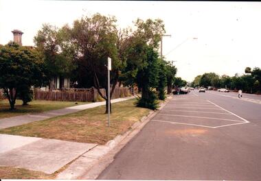
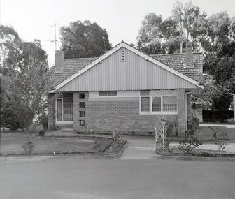
Photograph, Early 1990's
As Sunbury grew from a country town to an outer suburb the town centre and shopping centre expanded along Evans and O'Shanassy Streets. The Victorian cottage on the LHS of the photograph has been demolished and a KFC complex has been built in its place.A coloured photograph of Evans Street looking south with one of the remaining Victorian cottages on the LHS and angle parking areas along the curbside. The elm trees on the LHS of the road have been severely pruned. The roof top of the Sunbury Shopping Square is on the RHS above the treeline.shopping centres, sunbury shopping square, evans street, george evans collection -
 Hume City Civic Collection
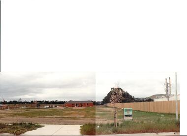
Photograph, early 1990s
The series of 5 photographs feature different views of the Woodlands housing development which opened up land bounded by Gap and Anderson Roads, Cornish Street and Elizabeth Drive in the early 1990s. It was a large housing development built close to Sunbury township.A coloured photograph of a new housing development taken in Anderson Road looking west towards Elizabeth Drive and the leisure centre. Some housing construction is in the middle distance.housing developments, anderson road, george evans collection -
 Hume City Civic Collection
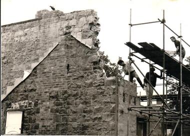
Photograph, Late 1970s
The Rupertswood Hotel was built on the NE corner at the intersection of Brook and Evans Streets. It was demolished in the late 1970s, in the dead of night, to make way for a modern retail area. In its heyday the two storey hotel was the pride of Sunbury and offered accommodation for rail travellers.A black and white photograph of a bluestone building which is being demolished. Three workmen are working from scaffolding which is on the RHS of the photograph.rupertswood hotel, hotels, evans street, brook street, cathie, james, goodby, norman, levvy, f.w., george evans collection -
 Hume City Civic Collection
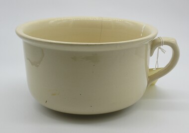
Domestic object - Chamber pot
This object was used in the home for toilet requirements before the advent of the indoor toilet as it saved a trip out to the backyard toilet during the night. Most toilets were built outside so the 'night cart' could come and empty them during the night.A large cream coloured procelain chamber pot with one handle on the side. hoffman, chamber pots, toilets, ceramics, george evans collection -
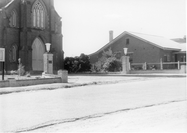 Stawell Historical Society Inc
Photograph, St. Matthew’s Church Memorial Entrance
Memorial entrance to St. Matthew’s Church. Erected by family of Robert Hill McCracken. Plaque inscription - To the Glory of God, and in memory of Robert Hill McCracken. Session clerk of this Church 1935 - 1955. The brick dwelling on the right is the Baptist Manse built 1935.Black & white photo of entrance to a Church with a building next door.stawell religion -
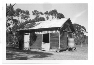
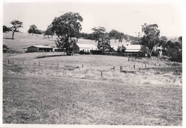 Hume City Civic Collection
Photograph, Emu Bottom Homestead
The photograph was taken from the rear of the Emu Bottom Homestead and its outbuildings in front of the home paddock. George Evans, one of the district's earliest European settlers built the original homestead from Silurian sandstone removed from the surrounding hillsides in the 1830s.A black and white landscape photograph with a cream border of a farm house and outbuildingsemu bottom homestead, homesteads, george evans, jackson creek, sunbury -
 Robin Boyd Foundation
Postcard, Ise Gropius, Ise Gropius to Patricia Boyd, Dec-73
The card brings new year wishes from Ise Gropius, the widow of Walter Gropius, to Patricia Boyd. The card shows the Gropius home built in 1937 in Lincoln Mssachusetts, which will be presented to The Society For The Preservation of New England Antiquities, by Ise Gropius.Large postcard with envelope -
 Old Colonists' Association of Ballarat Inc.
Photograph - Photograph - Colour, Clare Gervasoni, Guymer Cottage, Charles Anderson Grove, Ballarat, 2017, 14/06/2017
The Guymer Cottage was built in 1956. Dr Edward Albert Howes Guymer was born in 1891 and died in 1962 In 1946 Dr. E. A. H. Guymer was Vice-President of the Old Colonists' Association of Ballarat. He served as President from 1948-1950.Colour photograph of a red brick cottage at the Charles Anderson Grove Retirement Villagecharles anderson grove, ballarat, ballarat old colonists' club, old colonists' association, ballarat, guymer cottage, edward albert howes guymer, dr guymer -
 Old Colonists' Association of Ballarat Inc.
Photograph - Photograph - Colour, Thornton Richards, Guymer Cottage, Charles Anderson Grove, Ballarat, c1982, c1982
The Guymer Cottage was built in 1956. Dr Edward Albert Howes Guymer was born in 1891 and died in 1962 In 1946 Dr. E. A. H. Guymer was Vice-President of the Old Colonists' Association of Ballarat. He served as President from 1948-1950.Black and white photograph of a red brick cottage at the Charles Anderson Grove Retirement Villagecharles anderson grove, ballarat, ballarat old colonists' club, old colonists' association, ballarat, guymer cottage, edward albert howes guymer, dr guymer -
 Ballarat Tramway Museum
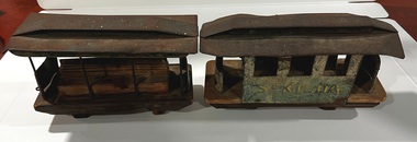
Model - Toy cable tram set, c1900
Built as a toy, either by a well resourced home workshop or by a toy maker. Have been well used or loved with missing wheels and damaged roof. Possibly dates from the early 1900s. St Kilda was a popular destination for Melbourne cable trams. Demonstrates a toy cable tram set.Cable tram set made from wood and pressed metal. Grip car or dummy has remnants of paint (green and gold) on the sides, holes for wheels on the two wood blocks on the underside. Has an eye hook at one end and a hole for another at the other end. Seat made from timber with a steel wire or rod to represent a grip lever. Metal secured to wood base with nails. Has four metal Staunchions on either side. Trailer similar construction with sides stamped or cut from sheet steel with holes at either end for a eye or hook and wheels. Roof on both items has been pressed and assembled. The trailer has painted on one side "St Kilda" and the remnants of a similar word on the other side.cable trams, toys, trams, st kilda -
 Ballarat Tramway Museum
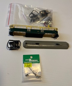
Model - Model Melbourne tram SW6 922 - partly assembled, Weico Models
Model of a Melbourne SW6 tram, partly assembled with parts in three plastic bags, including trolley poles. Painted Melbourne colours of green and cream. Model built by Weico. Has drop centre seats, the two saloons are left empty for motors.Demonstrates a model that represented a very successful Melbourne tram.Model Melbourne tram SW6 922 - partly assembled with parts in packing.models, tramcars, weico models, sw6 class, melbourne, tram 922 -
 Kew Historical Society Inc
Plan - Subdivision Plan, Six Big Home Sites, Camberwell North, c.1936
Subdivision plans are historically important documents used as evidence of the growth of suburbs in Australia. They frequently provide information about when the land was sold on which a built structure was subsequently constructed as well as evidence relating to surveyors and real estate and financial agents. The numerous subdivision plans in the Kew Historical Society's collection represent working documents, ranging from the initial sketches made in planning a subdivision to printed plans on which auctioneers or agents listed the prices for which individual lots were sold. In a number of cases, the reverse of a subdivision plan in the collection includes a photograph of a house that was also for sale by the agent. These photographs provide significant heritage information relating house design and decoration, fencing and household gardens.A subdivision in what is currently Balwyn, but which was advertised as being in Camberwell North. The subdivision included six allotments facing Buchanan Avenue and Houghton Street. The subdivision was to the east of the Pointed Firs Estate (1936). In addition to the intrinsic value of this subdivision plan, it also reveals information about the development of transport infrastructure in this area. The subdivision plan notes that the Tramways Board has approved the extension of the tram route past the current terminus at Balwyn Road.subdivision plans - camberwell -
 Kew Historical Society Inc
Plan - Subdivision Plan, Windella-Darnley Subdivision, Studley Park, 1920s
Subdivision plans are historically important documents used as evidence of the growth of suburbs in Australia. They frequently provide information about when the land was sold on which a built structure was subsequently constructed as well as evidence relating to surveyors and real estate and financial agents. The numerous subdivision plans in the Kew Historical Society's collection represent working documents, ranging from the initial sketches made in planning a subdivision to printed plans on which auctioneers or agents listed the prices for which individual lots were sold. In a number of cases, the reverse of a subdivision plan in the collection includes a photograph of a house that was also for sale by the agent. These photographs provide significant heritage information relating house design and decoration, fencing and household gardens.Version 1 of two subdivision plans (the later one is MAP.0027) for the section of Studley Park Road near the Junction on the south side. Named in the subdivision are the mansions of Darley and Windella (now demolished). Before the subdivision of Darley and Windella, both houses fronted Studley Park Road. Both houses appear to be advertised as lots in the subdivision. Bisecting the subdivision is a street, Antrim Avenue that was never constructed. A street, which was subsequently constructed in this vicinity, was Merrion Place, which now runs between Studley Park Road and Highfield Grove. There are 14 proposed lots in this subdivision."Antrim Avenue. See over for new plan"subdivision plans - kew, studley park, windella, darnley, studley park road -- kew (vic.), merrion place -- kew (vic.), merrion grove -- kew (vic.), highbury grove -- kew (vic.) -
 Kew Historical Society Inc
Plan - Subdivision Plan, Shop Sites, East Kew, c.1927
Subdivision plans are historically important documents used as evidence of the growth of suburbs in Australia. They frequently provide information about when the land was sold on which a built structure was subsequently constructed as well as evidence relating to surveyors and real estate and financial agents. The numerous subdivision plans in the Kew Historical Society's collection represent working documents, ranging from the initial sketches made in planning a subdivision to printed plans on which auctioneers or agents listed the prices for which individual lots were sold. In a number of cases, the reverse of a subdivision plan in the collection includes a photograph of a house that was also for sale by the agent. These photographs provide significant heritage information relating house design and decoration, fencing and household gardens.This is one of a small number of subdivision plans for commercial property in the collection. The subdivision proposed to create six shop sites in High Street between the Harp of Erin and Station Street. The plan shows this stretch of High Street, East Kew already lined with shops that include the hotel on the corner, the new State Savings Bank, a dentist’s surgery and Lambert’s Store. The High Street Tram was to reach Burke Road in 1925, so the proposed subdivision must postdate that event, and the opening of the Bank in 1926.subdivision plans - east kew, high street - east kew -
 Kew Historical Society Inc
Plan - Subdivision Plan, Eastlawn Estate, 1914
Subdivision plans are historically important documents used as evidence of the growth of suburbs in Australia. They frequently provide information about when the land was sold on which a built structure was subsequently constructed as well as evidence relating to surveyors and real estate and financial agents. The numerous subdivision plans in the Kew Historical Society's collection represent working documents, ranging from the initial sketches made in planning a subdivision to printed plans on which auctioneers or agents listed the prices for which individual lots were sold. In a number of cases, the reverse of a subdivision plan in the collection includes a photograph of a house that was also for sale by the agent. These photographs provide significant heritage information relating house design and decoration, fencing and household gardens.The ‘Eastlawn Estate’ was surveyed and ready for auction in March 1914, three months before the outbreak of World War I. Sixty-six allotments, created on the ‘order of Mr & Miss Preston’ surrounded the mansion of Woodlands in Harp Road. Woodlands formed part of the Estate, being advertised as lot 1. The allotments faced High, Station and Wright Streets, Harp and Normanby Roads, and Woodlands Avenue. Pru Sanderson in the Kew Conservation Study (Vol.2, 1988) wrote that the Eastlawn Estate ‘covered the western half of the failed Harp of Erin Estate’. Contemporary advertisements promoted the Eastlawn Estate as: ‘There will be no more convenient district nor pleasant Suburb than East Kew for the busy business man. When the Electric Tram is laid, he will be able to journey quickly and pleasantly direct from Collins Street to his home in the Eastlawn Estate in about 20 minutes’. The actual plans of subdivision were included in advertisements in The Argus and in the local newspapers.subdivision plans - east kew, eastlawn estate -
 Kew Historical Society Inc
Plan - Subdivision Plan, Raheen Estate Subdivision, 1960
Subdivision plans are historically important documents used as evidence of the growth of suburbs in Australia. They frequently provide information about when the land was sold on which a built structure was subsequently constructed as well as evidence relating to surveyors and real estate and financial agents. The numerous subdivision plans in the Kew Historical Society's collection represent working documents, ranging from the initial sketches made in planning a subdivision to printed plans on which auctioneers or agents listed the prices for which individual lots were sold. In a number of cases, the reverse of a subdivision plan in the collection includes a photograph of a house that was also for sale by the agent. These photographs provide significant heritage information relating house design and decoration, fencing and household gardens.The Raheen Estate Subdivision of 1960 involved the creation of 36 residential allotments and the sale of 34 of these. The land on which the subdivision was created had until 1960 formed part of the grounds of the mansion Raheen in Studley Park Road. In 1917, the Catholic Church had purchased Raheen and its lands. It was to become the home of Archbishop of Melbourne, Daniel Mannix, for 46 years. The sale of the subdivision took place three years before the Archbishop’s death. Subsequent archbishops were to reside at Raheen until its sale to the Pratt family in 1981. When the sale of the Estate was reported in the newspapers in 1960, it was described as the last big subdivision near Melbourne. At the auction, 33 of the 36 allotments were sold. The auction realised £315,750. Purchasers were advised that the vendor intended to keep lots 22 and 23. The alllotments in the subdivision required the construction of new roads. These included Eamon Court and Raheen Drive. The justification provided by the Church for the sale was that the estate was being sold to finance school building projects.subdivision plans - kew, studley park, raheen estate, eamon court, studley park road, coombes avenue, raheen drive -
 Sunbury Family History and Heritage Society Inc.
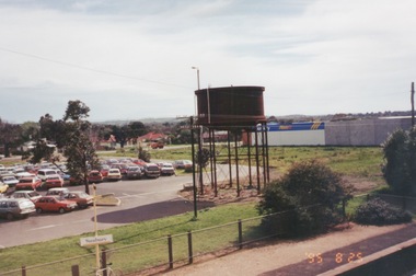
Photograph, 25th
The photograph of Sunbury was taken from the pedestrian bridge at the railway station and is looking NW to Horne Street and beyond. The water tower in the foreground was used to pump water into the steam train engines. Then commercial development on the site was built shortly before this photograph was taken.A coloured photograph of an elevated view of Sunbury with a metal water tower in the foreground and a car park with commercial buildings in the middle distance.sunbury, sunbury railway station, horne street -
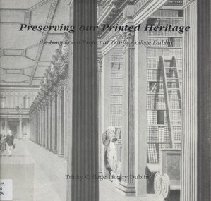 Surrey Hills Historical Society Collection
Book, Preserving our printed heritage: the Long Room Project at Trinity College Dublin, c1988
The Long Room was built between 1712 and 1732 to house the collections of books and manuscripts which had been growing since Trinity College's foundation in 1592. The staff faced the problems of space, access, and above all preservation. This booklet describes their journey.trinity college (dublin, ireland) library, books- ireland - conservation and restoration -
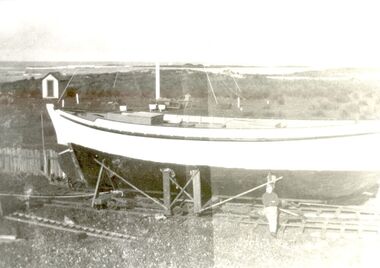 Port Fairy Historical Society Museum and Archives
Photograph
Amaryllis was the first fishing boat built by the Haldane Brothers in Port Fairy 1935. A well boat was on the Port Fairy register from 1936 -1943 in the name of W.H.Haldane. She was requisitioned by the armed services during 1943 and did not return to Port Fairy. Black and white photograph of Bill Haldane standing with his boat Amaryllis as it nears completion on Griffith Islandfish, fishing, boat, industry, amaryllis, haldane, w.h.haldane, bill haldane, griffith island, haldane brothers -
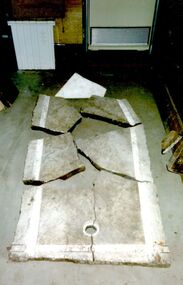 Port Fairy Historical Society Museum and Archives
Photograph
The marble shown in this photograph was collected by Mr Leo Brady from the Bank Street site of the Public Baths that were built there in the late 1800’s. These were sea baths and the water was pumped across from the South West Passage via a windmill.This is was all that remained of the public sea baths. The Historical Society also has two small pieces of marble and a long bolt that held the marble togetherColoured photograph of the broken marble base of one of the baths at the Public Bathsemployee, industry, marble, public baths, leo brady, bank street -
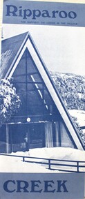 Falls Creek Historical Society
Booklet - Ripparoo Lodge, 1973
Ripparoo Lodge was one of the earliest Lodges established in the Falls Creek Village. In the 1960s, Bob and Noelene Lee moved to Falls Creek to run Ripparoo Lodge. They later built Attunga Ski Lodge. Both of these lodges still operate successfully in the 2020s.This brochure is significant because it represents one of the early lodges at Falls Creek. A fold out brochure printed in blue and white, it include some images and cartoons of people enjoying hospitality at Ripparoo. Information on tariffs and services is included.Title - Ripparoo The happiest ski lodge in the village.falls creek accommodation, ripparoo, falls creek lodges -
 Tarnagulla History Archive
Photograph of former Tarnagulla Police Stable, Former Tarnagulla Police Stable, Mid 20th Century
Murray Comrie Collection. The town block where this stable was located was the base for policing in Tarnagulla from 1878 until the 1990s. The block was bounded by Stanley, Victoria, Wood and Gladstone Streets. The stable was built in 1886. An image of the stable in 1924 is THA-2019.0031. Monochrome photograph of a stable which once housed police horses in Tarnagulla. Dark red or brown weatherboard with white doors. tarnagulla, police, policing, horses, buildings -
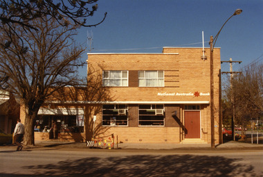 Charlton Golden Grains Museum Inc
Photograph, NAB High St Charlton 1987, c.1987
National Australia Bank building 1987. Established as the Bank of Victoria in 1876, later became Commercial Banking Company of Sydney. Current building built in c. 1940 and later became NAB. Part of Charlton Shire streetscape series taken in 1987.Colour photograph of the National Australia Bank, corner of High St and Armstrong St. Two story building with white curtains in two upper storey windows. Entrance doors are shut. Man crossing High St on LH side of photo. Someone in the entrance of the shop on the left of the Bank. Safety tape and barricade attached to parking sign in front of Bank.national australia bank, commercial banking company, bank of victoria, charlton shire, business, industry -
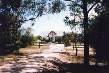 Lakes Entrance Historical Society
Photograph - Housing, 1999
Built late 1970's or early 1980's by Roger Simpson, cabinet maker. Internal space originally had large banquet hall in centre, surrounded by kitchen and utilities, bedrooms upstairs overlooking hall. It has since been modified.Colour photograph of a mock Tudor dwelling at Colqhuoun Road. Corrugated iron gable roof across building. Gable roofed projection centre front. Dark painted lathes on outer walls add to Tudor effects. Set well back from road with established garden. Lakes Entrance Victoriahouses, architecture -
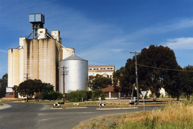 Charlton Golden Grains Museum Inc
Photograph, Charlton Shire, Charlton Flour Mill, c.1987
A previous mill had operated in Charlton by Mr. W.E. Foreman on the banks of the Avoca River and was acquired in 1919 by Noske Bros. The present Flour Mill was built by Noske Bros and opened in May 1927. It was taken over by the Grain Elevator Board in the 1970s. Colour photograph of Charlton Flour Mill and silos. Intersection of Kaye & Davies Streets in the foreground. One large silver silo and three taller greyish concrete silos to the left. Three other cream coloured silos behind. There are pipes and sheds on top of the silos. There is a cream single story building to the right of the silver silo and a multi-storey building behind with eight window in the upper level. There is a small red brick building on the far left of the photo.w.e. foreman, noske bros, flour mill charlton, business, industry -
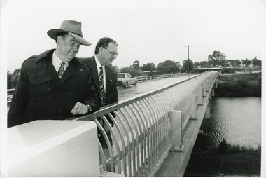 Lakes Entrance Historical Society
Photograph - Bridges, Lakes Post Newspaper, 1995
The first concrete bridge built over Tambo River at Swan Reach, in 1932 was never officially opened, so the opening of the refurbished bridge on 19 December 1995 was declared 'The Official Opening'. Photo taken at the Official Opening 19 December 1995Black and white photograph showing David Treasure, MLA, and Norm Butler of VicRoads, on the strengthened and widened bridge, over the Tambo River at Swan Reach, Victoria.bridges, waterways, officials -
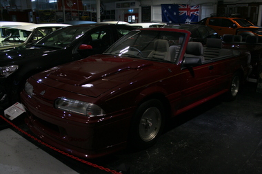 Trafalgar Holden Museum
Vehicle - 1986 VL Commodore convertible
This car was built by engineering students employed by GMH. It was initially against the wishes of management, but they relented and gave permission to go ahead, as long as the work done was not during paid hours and that the car would be crushed upon completion. Fortunately, the latter did not happenOnce of unit made by TAFE students for the Melbourne motor showMaroon in colour with gold pinstriping . Group A bonnet scoop and front bumperGM Lion emblem on frontvehicle, 2 door, static -
 Ballarat Tramway Museum
Photograph - Digital images of Ballarat Horse Tram No. 1 being recovered, Peter Winspur, 13-12-1985
Shows the state of the body of that the Ballarat Tramway Preservation Society recovered of the 1887 Horse Tram from the rear of a property in Anderson St Balllarat. The body was built by Duncan and Fraser in Adelaide. The tram body was reconstructed by the BTPS and made operable by the Museum in 1992Yields information about the condition of the body of Ballaarat Tramway Co. Horse Tram No. 1 of 1887. Set of two digital images of the recovery of Ballaarat Tramway Co. Horse Tram No. 1 on 13-12-1985 .1 - Body placed on a tandem trailer in Anderson St, Ballarat .2 - Body of Ballarat Horse tram No. 1 on a set of wheels at the depothorse tram, btps, ballarat, tram no. 1, tram recovery -
 Charlton Golden Grains Museum Inc
Photograph, Massingham, G. L., (George Leake), St Martin's Anglican Church 1901, c.1901
St Martin's Anglican Church Armstrong St Charlton c. 1901, built in 1889. The weatherboard church was used until the early 1960s when it was replaced by the current brick building. The cataloguing sheet lists Mr John Gidley King in the photo.Mounted, unframed black & white photographst martin's anglican church, armstrong st charlton, pastoral care, church, angllican -
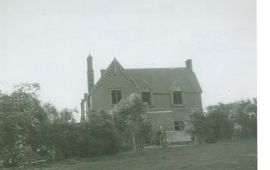 Sunbury Family History and Heritage Society Inc.
Photograph, Rosa McCall, Cumberland Homestead, 1951
The homestead in the image is 'Cumberland' which was sited along the Moonee Ponds Creek, near Gellibrand Hill. It was built by Donald Coghill, who acquired the land some time in the 1850s. During the first half of the twentieth century it was uninhabited until it was finally demolished.'Cumberland' was one of a number of homesteads that were built by European settlers in the Bulla area in the 1850s. A non-digital black and white photograph of a double storey Victorian homestead set in an open area.cumberland homestead, moonee ponds creek, gellibrand hill, donald coghill