Showing 7094 items matching "snowy-river"
-
 Greensborough Historical Society
Photograph - Digital Image, Pioneer Reserve 2014 -2, 01/10/2014
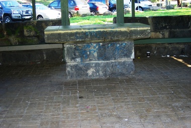
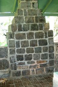
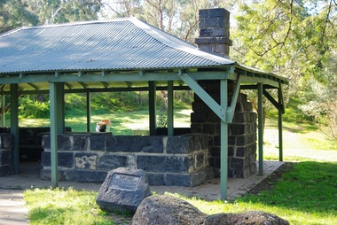
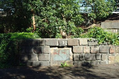
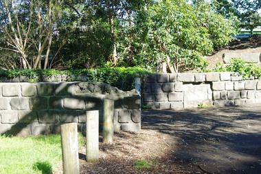
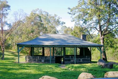
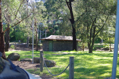
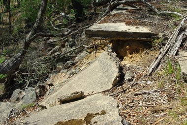
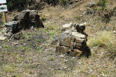
Pioneer Reserve, Greensborough is a small park on the corner of St Helena and Diamond Creek Roads. It is adjacent to the site of Greensborough's first bridge across the Plenty River, c. 1864 - 1960s. The shelter, viewing platform, retaining wall and entrance are built from the bridge's massive bluestone arched abutments dismantled between 1974 and 1983. Photograph by Marilyn Smith 2014.Digital copy of colour photograph.pioneer reserve greensborough -
 Greensborough Historical Society
Photograph - Digital Image, Pioneer Reserve 2014 -3, 01/10/2014
Pioneer Reserve, Greensborough is a small park on the corner of St Helena and Diamond Creek Roads. It is adjacent to the site of Greensborough's first bridge across the Plenty River, c. 1864 - 1960s. The shelter, viewing platform, retaining wall and entrance are built from the bridge's massive bluestone arched abutments dismantled between 1974 and 1983. Photograph by Marilyn Smith 2014.Digital copy of colour photograph.pioneer reserve greensborough -
 Greensborough Historical Society
Photograph - Digital Image, Pioneer Reserve 2014 -4, 23/09/2014
Pioneer Reserve, Greensborough is a small park on the corner of St Helena and Diamond Creek Roads. It is adjacent to the site of Greensborough's first bridge across the Plenty River, c. 1864 - 1960s. The shelter, viewing platform, retaining wall and entrance are built from the bridge's massive bluestone arched abutments dismantled between 1974 and 1983. Photograph by Marilyn Smith 2014.Digital copy of colour photograph.pioneer reserve greensborough -
 Greensborough Historical Society
Photograph - Digital Image, Pioneer Reserve 2014 -5, 23/09/2014
Pioneer Reserve, Greensborough is a small park on the corner of St Helena and Diamond Creek Roads. It is adjacent to the site of Greensborough's first bridge across the Plenty River, c. 1864 - 1960s. The shelter, viewing platform, retaining wall and entrance are built from the bridge's massive bluestone arched abutments dismantled between 1974 and 1983. Photograph by Marilyn Smith 2014.Digital copy of colour photograph.pioneer reserve greensborough -
 Greensborough Historical Society
Photograph - Digital Image, Pioneer Reserve 2014 -6, 23/09/2014
Pioneer Reserve, Greensborough is a small park on the corner of St Helena and Diamond Creek Roads. It is adjacent to the site of Greensborough's first bridge across the Plenty River, c. 1864 - 1960s. The shelter, viewing platform, retaining wall and entrance are built from the bridge's massive bluestone arched abutments dismantled between 1974 and 1983. Photograph by Marilyn Smith 2014.Digital copy of colour photograph.pioneer reserve greensborough -
 Greensborough Historical Society
Photograph - Digital Image, Pioneer Reserve 2014, 23/09/2014
Pioneer Reserve, Greensborough is a small park on the corner of St Helena and Diamond Creek Roads. It is adjacent to the site of Greensborough's first bridge across the Plenty River, c. 1864 - 1960s. The shelter, viewing platform, retaining wall and entrance are built from the bridge's massive bluestone arched abutments dismantled between 1974 and 1983. Photograph by Marilyn Smith 2014.Digital copy of colour photograph.pioneer reserve greensborough -
 Greensborough Historical Society
Photograph - Digital Image, Pioneer Reserve 2014 -8, 23/09/2014
Pioneer Reserve, Greensborough is a small park on the corner of St Helena and Diamond Creek Roads. It is adjacent to the site of Greensborough's first bridge across the Plenty River, c. 1864 - 1960s. The shelter, viewing platform, retaining wall and entrance are built from the bridge's massive bluestone arched abutments dismantled between 1974 and 1983. Photograph by Marilyn Smith 2014.Digital copy of colour photograph.pioneer reserve greensborough -
 Greensborough Historical Society
Photograph, Gildings bootmaker, 1888c
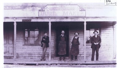
Photograph of four men standing on the porch of Gildings Bootmaker's shop in Main Street Greensborough. John Gilding is standing in front of doorway. Harness maker W. Woodward stands next to him. The shop was opposite the Greensborough Fire Station in Church and in 1885 his shop and home were moved to the lower end of Main Street near the Plenty River.Links: 00374:01277:01278:01279:01280 Copy of black and white photographjohn gilding, gilding family -
 Greensborough Historical Society
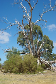
Photograph - Digital image, Marilyn Smith et al, Janefield Precinct: dead gum tree and box thorns, 27/11/2014
Janefield Precinct: dead gum tree and box thorns. The remains of this site are between Greensborough and Janefield. A RAAF Hygiene Training Camp was located on the Plenty River, just south of the Janefield community. It was in use from 1944 to 1946. The Camp was constructed from salvaged materials. Instruction included building and maintenance of grease traps, latrines, elementary plumbing and carpentry.Early remains of a WW2 training campDigital colour photograph.janefield, raaf hygiene training camp janefield -
 Greensborough Historical Society
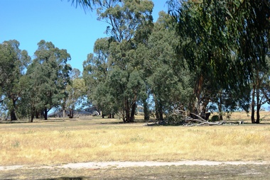
Photograph - Digital image, Marilyn Smith et al, Janefield Precinct: Looking towards the future - new residential development, 27/11/2014
Janefield Precinct: Looking towards the future - new residential development. The remains of this site are between Greensborough and Janefield. A RAAF Hygiene Training Camp was located on the Plenty River, just south of the Janefield community. It was in use from 1944 to 1946. The Camp was constructed from salvaged materials. Instruction included building and maintenance of grease traps, latrines, elementary plumbing and carpentry.Early remains of a WW2 training camp Digital colour photograph.janefield -
 Greensborough Historical Society
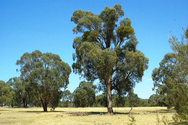
Photograph - Digital image, Marilyn Smith et al, Janefield Precinct: Looking toward grave area from camp, 27/11/2014
Janefield Precinct: Looking toward grave area from camp. The remains of this site are between Greensborough and Janefield. A RAAF Hygiene Training Camp was located on the Plenty River, just south of the Janefield community. It was in use from 1944 to 1946. The Camp was constructed from salvaged materials. Instruction included building and maintenance of grease traps, latrines, elementary plumbing and carpentry.Early remains of a WW2 training camp Digital colour photograph. -
 Greensborough Historical Society
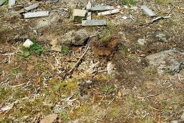
Photograph - Digital image, Marilyn Smith et al, Janefield Precinct: Cut Bluestone blocks from old building, 27/11/2014
Janefield Precinct: Cut Bluestone blocks from old building. The remains of this site are between Greensborough and Janefield. A RAAF Hygiene Training Camp was located on the Plenty River, just south of the Janefield community. It was in use from 1944 to 1946. The Camp was constructed from salvaged materials. Instruction included building and maintenance of grease traps, latrines, elementary plumbing and carpentry.Early remains of a WW2 training camp Digital colour photograph. -
 Greensborough Historical Society
Photograph - Digital image, Marilyn Smith et al, Janefield Precinct: Decaying slabs near edge of cliff, 27/11/2014
Janefield Precinct: Decaying slabs near edge of cliff. The remains of this site are between Greensborough and Janefield. A RAAF Hygiene Training Camp was located on the Plenty River, just south of the Janefield community. It was in use from 1944 to 1946. The Camp was constructed from salvaged materials. Instruction included building and maintenance of grease traps, latrines, elementary plumbing and carpentry.Early remains of a WW2 training camp Digital colour photograph. -
 Greensborough Historical Society
Photograph - Digital image, Marilyn Smith et al, Janefield Precinct: Old fire place on lower terrace, 27/11/2014
Janefield Precinct: Old fire place on lower terrace. The remains of this site are between Greensborough and Janefield. A RAAF Hygiene Training Camp was located on the Plenty River, just south of the Janefield community. It was in use from 1944 to 1946. The Camp was constructed from salvaged materials. Instruction included building and maintenance of grease traps, latrines, elementary plumbing and carpentry.Early remains of a WW2 training camp 2 Digital colour photographs. -
 Greensborough Historical Society
Photograph - Digital image, Marilyn Smith et al, Janefield Precinct: Outside building next to admin block, 27/11/2014
Janefield Precinct: Outside building next to admin block. The remains of this site are between Greensborough and Janefield. A RAAF Hygiene Training Camp was located on the Plenty River, just south of the Janefield community. It was in use from 1944 to 1946. The Camp was constructed from salvaged materials. Instruction included building and maintenance of grease traps, latrines, elementary plumbing and carpentry.Early remains of a WW2 training camp Digital colour photograph. -
 Greensborough Historical Society
Photograph - Digital image, Marilyn Smith et al, Janefield Precinct: World War 2 era concrete and guttering, 27/11/2014
Janefield Precinct: World War 2 era concrete and guttering. The remains of this site are between Greensborough and Janefield. A RAAF Hygiene Training Camp was located on the Plenty River, just south of the Janefield community. It was in use from 1944 to 1946. The Camp was constructed from salvaged materials. Instruction included building and maintenance of grease traps, latrines, elementary plumbing and carpentry.Early remains of a WW2 training camp Digital colour photograph.janefield -
 Greensborough Historical Society
Photograph, Greensborough Tennis Club, 1960s, 1963c
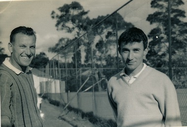
From caption on back: Photograph of Robert (Bob) Maurer (left) and Barry Keith Taylor, now dec. (right). Greensborough Tennis Club near Plenty River mid 1960s. Barry's parents lived behind the Commercial Bank of Australia in Main Street; Greensborough. He attended Ivanhoe Grammar early 1960s. Very good tennis player.Original photograph of Greensborough Tennis Club players 1960s.Black and white photograph of two men at tennis club.Caption on back of photo.greensborough tennis club, robert maurer, barry keith taylor, rosemary isaacs -
 Kiewa Valley Historical Society
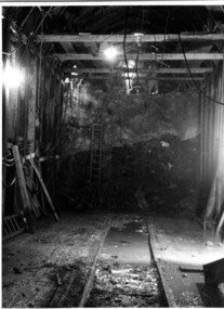
Photograph Tailrace tunnel Arch Drive, Tunnel face at Tailrace showing Arch Drive, between 1943 and 1952
This photo was taking during construction of the tailrace tunnel between West Kiewa Power Station and Mt. Beauty. Much of the area was unstable and timber supports were erected prior to concreting. The tunnel was commenced in 1941 and completed in 1952. It brings water from the power station into the open tailrace at Mt. Beauty and then into the regulating pondage before discharge into the Kiewa River.Shows method of construction for supporting walls and ceiling of tunnel with timber, size of tunnel (note worker on upper level), and conditions in the work place during construction in the 1940's/50's - note the timber ladder to gain access to the upper level.Black and white photographHand written on back of photograph "Tunnel face at Tailrace showing Arch Drive".tailrace, power station, water, construction -
 Orbost & District Historical Society
black and white photograph, 1934
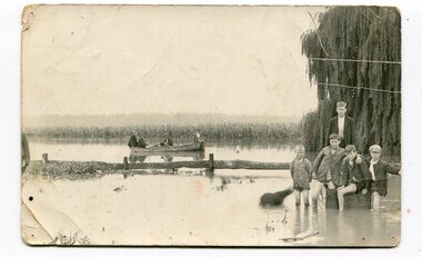
This photograph was taken during the flood of 1934 in Orbost. The people in the photograph are related to Billie and Ilma Nixon and Charlie Johnston. Damage estimated at £500,000 was caused by the 1934 floods in the Orbost district. This 1934 flood was devastating, destroying a section of the 1922 Orbost bridge, wrecking fences, bridges and roads, dumping silt and debris on the rich river flats and drowning cattle.This item is a pictorial record of a significant event in Orbost's history. It is associated with local families.A black / white photograph / postcard of floodwaters. On the right is a young man with four young boys sitting on a log. In the bckground is a rowing boat with one man rowing and three others sitting on the edges . A field of maize / corn is in the background and a large willow tree on the right.on back - "M. C. Rice Orbost 19 /1/20 M Gilbert. Mostly Billy Nixons & Charlie Johnstons 1934" [Note alteration: W C Rice rather than M C Rice].floods-orbost-1934 nixon-william johnston-charles -
 Port Melbourne Historical & Preservation Society
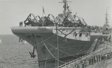
Photograph - British aircraft carrier HMS Indefatigable, Station Pier, Port Melbourne, Roy Liebig, Jan 1946
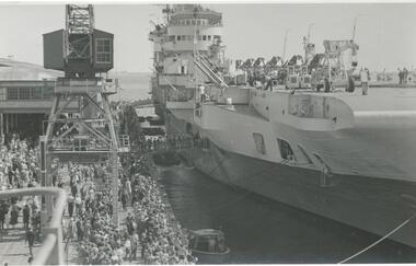
On Wednesday 23 Jan 1946 British aircraft carriers HMS Indefatigable, HMS Implacable and HMS Glory escorted by destroyers HMS Tuscan and HMS Armada arrived in Melbourne. Indefatigable berthed at outer west Station Pier, Glory at inner east and Implacable at outer east. The Tuscan and Armada proceeded up the river Yarra and berthed at South Wharf.A series of photographs taken by Roy Liebig in the 1940s Hard copy and digital. British aircraft carrier HMS Indefatigable at the outer west berth of Station Pier in Jan 1946. The photo shows many visitors on the pier.maritime, war - world war ii, roy liebig, karen bowden, piers and wharves - station pier, hms indefatigable -
 Victorian Interpretive Projects Inc.
Image of souvenir ware, Apollo Bay
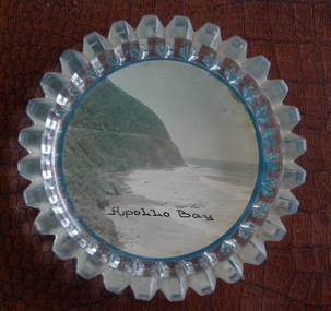
Apollo Bay is located between Wye River and Cape Otway on Victoria's scenic coastal route, the Great Ocean Road. In the 1840s the Henty brothers established a whaling station at Point Bunbury on the western end of the bay. The bay was named by Captain Loutit in 1845 when he sheltered his vessel, the Apollo during a storm. (http://en.wikipedia.org/wiki/Apollo_Bay)A coloured picture of a coastline attached to a glass butter plate. The coastline is Cape Patton, Apollo Bay, Victoria"Apollo Bay"apollo bay, beach, coast, souvenir -
 Otway Districts Historical Society
Photograph, Brucker, Gellibrand station, 1922, 1922
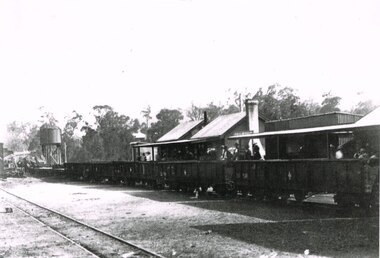
Gellibrand station became the railhead for traffic to the Carlisle River and Lardners, as well as the centre of timber and fruit trade. Outward loading was substantial at the time the photograph was taken. Sawn and split timber, firewood, sleepers and piles were loaded in large quantities. The general expansion in traffic led in October 1923 to the laying of an additional loop siding and provision for a goods shed., B/W. In 1922, Gellibrand station with passengers and workmen on the station concourse, and NQR wagons aligned ready to move. Note the water tank on the left and the start of the Refreshment Room on the right.gellibrand; railways; -
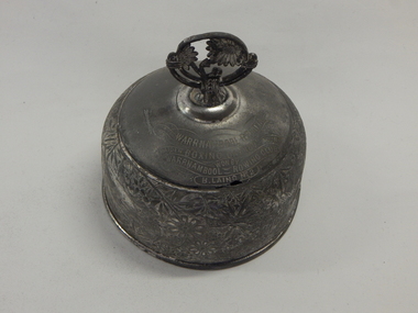 City of Warrnambool Rowing Club
Trophy, 1891
The Warrnambool Regatta was held on the Hopkins River on Sunday 27 December 1891. B. Laing rowed for the Warrnambool Rowing Club. A trophy was given to each member of the Maiden Four crew- A. Lumsden (bow), B. Laing (2), D. Rowan (3), J. Rowan (stroke), A. Geilhofer (cox). B. Laing was also a steward in the St John's Lodge.Brass bell shaped dome with a 4 cm circular hoop containing a tree motif.Warrnambool Regatta Boxing Day 1891 Maiden Four. Warrnambool Rowing Club. B. Laing No 2.trophy, warrnambool, 1891, rowing, hopkins river -
 Port Fairy Historical Society Museum and Archives
Photograph
Cowton and Bland were brothers in law and began their partnership in 1847 in an import/export business similar to that of Rutledge and Co., although a lot smaller in scale. Later, the partnership acquired other land on the river front in Gipps Street where they had a wharf and bonded stores . The partnership lasted until 1864. Both men had been sea captains.No other photograph is known to exist of the half round store that is shown here Black and white photograph of bullock team with wagon in Bank Streettransport, rail, road, cowton and bland, import, export -
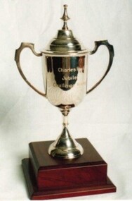 Royal Brighton Yacht Club
Trophy, Charles Peel Trophy
Charles Peel Trophy Donor: Peter Mitcheson Deed of Gift: No Peter was the nephew of Charles Peel who was one of the designers of the Jubilee class yacht first launched with Freydis BJ1 in 1935. Peter also at one time owned the Jubilee yachts Freydis BJ1 and Sylvia BJ2. Sylvia was destroyed in a collision with a ship at the mouth of the Yarra River. First Winner: jubilees, peel, freydis, mitcheson -
 Wodonga & District Historical Society Inc
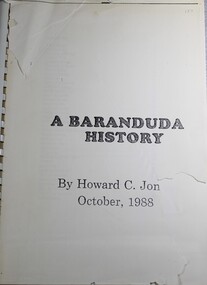
Book - A Baranduda History, Howard C Jones, 1988
A history of Baranduda in Northeast Victoria. Baranduda is a rural area and, since the 1970s, a rural and residential locality formed under the authority of the Albury Wodonga Development Corporation. It is near the junction of Yackandandah Road and the Kiewa Valley Highway, 10 km south-east of Wodonga. This publication traces the history of the area from its earliest know indigenous inhabitants, through the days of the earlier establishment of pastoral runs to more recent developments.Spiral boundnon-fictionA history of Baranduda in Northeast Victoria. Baranduda is a rural area and, since the 1970s, a rural and residential locality formed under the authority of the Albury Wodonga Development Corporation. It is near the junction of Yackandandah Road and the Kiewa Valley Highway, 10 km south-east of Wodonga. This publication traces the history of the area from its earliest know indigenous inhabitants, through the days of the earlier establishment of pastoral runs to more recent developments.baranduda, pioneers victoria, huon family, wodonga pioneers -
 Greensborough Historical Society
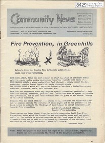
Newsletter, Greenhills and North Greensborough Progress Association, Community News: official journal of the Greenhills and Nth. Greensborough Progress Association. 25th Nov., 1972. Edition No. 9/72, 25/11/1972
This edition includes a report on the Progress Association's November 1972 meeting, Councillors' reports, Fire prevention in Greenhills, Talking about natives, More trains?, Open Forum, Letter to the Editor. Supplement to November 1972 "Community News" Competition, Plenty River clean-up, Diamond Valley Repertory. A digital copy of this Newsletter is available from Greensborough Historical Society.Newsletter, 24 p., illus.greenhills and north greensborough progress association, greenhills -
 Greensborough Historical Society
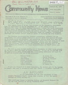
Newsletter, Greenhills and North Greensborough Progress Association, Community News: official journal of the Greenhills and North Greensborough Progress Association. 20th July 1970. Edition No. 6/70, 20/07/1970
This edition includes a report on the Progress Association's July1970 meeting, Councillors' report, Roads, nature or "nature strips", Protecting and improving the Plenty River, Toxic insecticides - the total dangers, New park complex to be Bundoora Fields, School and Kinder news, Scout and Guide news, Letter to editor. A digital copy of this Newsletter is available from Greensborough Historical Society.Newsletter, 16 p., illus. greenhills and north greensborough progress association, greenhills -
 Port Melbourne Historical & Preservation Society
Photograph - British aircraft carrier HMS Glory, Station Pier, Port Melbourne, Roy Liebig, Jan 1946
On Wednesday 23 Jan 1946 British aircraft carriers HMS Indefatigable, HMS Implacable and HMS Glory escorted by destroyers HMS Tuscan and HMS Armada arrived in Melbourne. Indefatigable berthed at outer west Station Pier, Glory at inner east and Implacable at outer east. The Tuscan and Armada proceeded up the river Yarra and berthed at South Wharf.A series of photographs taken by Roy Liebig in the 1940s Hard copy and digital. British aircraft carrier HMS Glory at the inner east berth of Station Pier in Jan 1946. The photo shows aircraft (with folded wings) on the deck of the carrier, many visitors on the pier and the superstructure of HMS Implacable berthed behind at outer east.maritime, war - world war ii, roy liebig, karen bowden, piers and wharves - station pier, hms glory, hms implacable -
 Kiewa Valley Historical Society
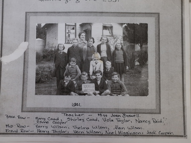
Photo - Mullindilongong School 1941
The Mullindolingong school was opened in 1881 and was across the river from Tawonga State School with which it worked half-time from 1881 to 1894. The school was closed don from 1894 to 1923 in a different location. In 1949 it was renamed Coral Bank.It finally closed in 1954 and became part of Dederang School. Ref. Vision and Realisation Vol. 3 Page 981.This is one of a few photos of Mullindilongong School and its teacher and pupils. It also is an example of school clothes worn to a country school in 1941.Photocopy of a black and white photo that had been glued onto a cardboard backing. The footballers are named at the bottom on the cardboard.1941. Teacher Miss Joan Boswellmullindolingong state school 1941, students 1941, state school