Showing 7095 items matching "snowy-river"
-
 Orbost & District Historical Society
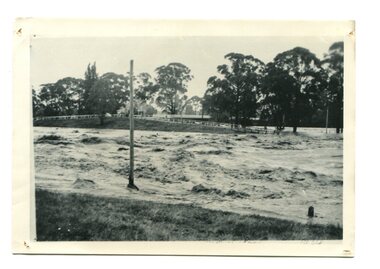
black / white photograph, January 1934
Damage estimated at £500,000 was caused by the 1934 floods in the Orbost district. This 1934 flood was devastating, destroying a section of the 1922 Orbost bridge, wrecking fences, bridges and roads, dumping silt and debris on the rich river flats and drowning cattle. This photograph shows Lochiel Lagoon ( the billabong) in the foreground. Ten minutes after this photograph was taken, the centre span of the Orbost Bridge was washed away.This item is a pictorial record of the 1934 floods, a significant part of Orbost's history.A black / white photograph of swirling floodwaters with township in the background.orbost-floods-1934 natural-disasters-floods -
 Bendigo Military Museum
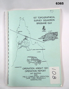
Administrative record - Royal Australian Survey Corps Report on Operation Aright 91 conducted by 1 Field Survey Squadron 1991, 1 Fd Svy Sqn, 7 Oct 1991
Royal Australian Survey Corps Operation Aright 91 (Field Completion) was a Field Verification and Vital Assets Protection (VAP) Mapping Operation conducted in Far North Queensland during the period 18 Jun - 29 Jul 1991 by 1 Fd Svy Sqn. The Operation covered the 1:250,000 Map area of SD54-16 Hann River and SE54-7 Normanton.Pale Blue cover with motifs of North Queensland, crocodile, RASvy Corps Badge, Army Helicopter and Land rover. Contains an A4 paper report of typed pages and diagrams secured by a plastic binder.Cover Hand annotated "ASS 108" (Air Survey Sqn, copy 108)royal australian survey corps, rasvy, fortuna, army survey regiment, army svy regt, asr -
 Warrnambool and District Historical Society Inc.
Sale Poster, Mercer Print, "Arran" 1967, 1967
This Auction notice is for the sale of an Ellerslie property called "Arran" , owned by Mr Philip M. Ormsby. The date of the auction is Thursday 16th February 1967. Vendors solicitors are Archer Naughtin and Forrest of Mortlake and the sale agents are Dennys, Lascelles Limited. Portions of "Arran" had been in the family since 1865. The property has 3/4 mile frontage to the Hopkins river.This sale notice is of general interest as a well established property in a good farming region. Long sheet with sale details of the property Arran The majority of the text is black with some highlighted in red.There is a map of the property on the reverse.warrnambool, arran, ellerslie -
 Warrnambool and District Historical Society Inc.
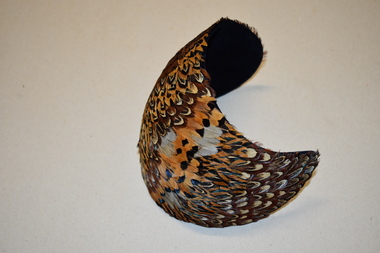
Feathered Hat, Custom Hats, c. 1940
This item comes from the great aunts of the donor, women of the Kinnear family of Allandale, Allansford. In the early 1840s William and John Allan took up large tracts of land to the east of the Hopkins River. In the late 19840s the run was divided, with William taking the Allandale section and John taking the Tooram section. In 1906 a portion of the Allandale section, including the homestead, was acquired by the Kinnear family. This hat is retained as an example of a woman’s hat from 80 years ago – stylish and eye-catching. It is also of interest as coming from the Kinnear family of Allansford.This is a woman’s hat – a spherical-shaped piece of dark blue felt or velvet curved to fit a head. The headpiece is covered with layers of small feathers in brown, yellow, black and white tonings. The label of the maker is on the inside of the hat. Urbi et Orbi Custom Hats Yokohamavintage hats, kinnear family, allansford, history of warrnambool -
 Eltham District Historical Society Inc
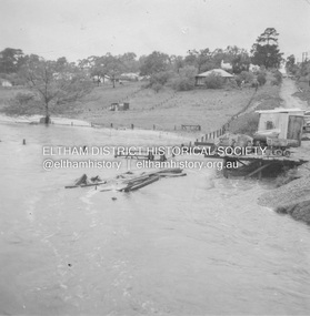
Album - Photograph, J.A. McDonald, Eltham-Greensborough Road, 18 Oct. 1956
Bridge Street Bridge Flooding on Waterfall’s Estate 18th October 1956 Looking east up to Main Road over what is now present-day Alistair Knox Park Beware!.. our rivers are rising (1956, October 19). The Argus (Melbourne, Vic. : 1848 - 1957), p. 1. Retrieved August 24, 2022, from http://nla.gov.au/nla.news-article84392304Record of various Shire of Eltham infrastructure works undertaken during the period of 1952-1962 involving bridge and road reconstruction projects, sometimes with Eltham Shire Council Project Reference numbers quoted. It was during this period that a number of significant improvements were made to roads and new bridges constructed within the shire that remain in place as of present day (2022). In many situations, the photos provide a tangible visible record of infrastructure that existed throughout the early days of the Shire. The album was put together by or under the direction of the Shire Engineer, J.A. McDonald.infrastructure, road construction, shire of eltham, bridge construction, bridge street bridge, eltham, eltham-greensborough road, 1956-10-18, diamond creek (creek), floods, floodwater, silver street bridge, alistair knox park, waterfall property -
 Eltham District Historical Society Inc
Photograph, Fay Bridge, Yellow Box Gum tree near junction of Main Yarra Trail and Mullum-Mullum Trail, Templestowe, 7 July 2019
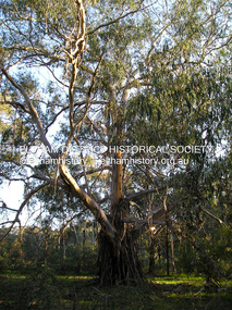
Situated in the wetlands on the trail opposite the Pontville Homestead, former home of Major Charles Newman and across the Yarra River from Sweeneys Flats, Eltham. Newman also purchased Allotment 5, Section 2 (in Ely Street, Eltham) at public autction on 17 September 1851. It was the only Section 2 allotment purchased at the firts Elthan Town Allotments public auction.fay bridge collection, sweeneys flats, 2019-07-07, major charles newman, mullum mullum creek, pontville homestead, significant tree, yellow box gum (eucalyptus melliodora) -
 Greensborough Historical Society
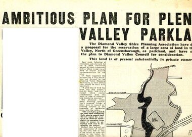
Newspaper Clipping - Digital Image, Ambitious plan for Plenty Valley Parklands 1965, 05/11/1965
In 1965, the Diamond Valley Shire planning association recommended to Council that a large area of land north of Greensborough be acquired for Parkland. The idea of a Civic Centre was included with a map of the area from Grimshaw Street in the south to the MMBW pipeline reserve in the north. Includes a suggested new site for the local school, near Yando Street. This area is now part of the Plenty River Trail.An example of developments in the Greensborough area during the period of Shire of Diamond ValleyNews clipping, black and white text and map. Scanned in 3 parts.shire of diamond valley, civic drive greensborough, yando street greensborough, partingtons flat, plenty river trail -
 Greensborough Historical Society
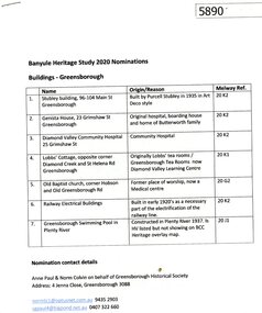
Document - Submission, Anne Paul et al, Banyule Heritage Study 2020 Nominations: Buildings - Greensborough, 2020
Descriptions and photographs of seven early building of historical interest in Greensborough, nominated for the Banyule Heritage Study 2020 by Norm Colvin and Anne Paul on behalf of the Greensborough Historical Society. Buildings include: Stubley building, Genista house, Diamond Valley Community Hospital, Lobb's Cottage, Old Baptist church, railway electrical buildings, swimming pool in Plenty River at Greensborough.8 p., text and colour photographs.historic buildings, banyule heritage study 2020, greensborough -
 Mission to Seafarers Victoria
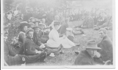
Photograph - Photograph, Sepia, Anne Treverton Goldsmith (nee Lobb), c. 1906
The Ladies Harbour Light Guild was formed between 1905 and 1906. A popular activity hosted by the LHLG were picnics for annual Celebrations such as the festive season. There are a number of small similar photographs which suggest this outing may have been one of the first picnics held in 1905 at Brighton. Other popular spots were the Zoo and large gardens or the river up near Kew.Possibly this image was taken at the inaugural picnic in 1905 which was the first occasion hosted by the formal association of the LHLG. small sepia tone photograph with tear depicting large crowd of seafarers with women in Edwardian dress enjoying a picnic. small pencil marking on upper right: (indecipherable)lhlg, seafarers, picnic, seamen, ladies, ladies harbour lights guild, anne treverton goldsmith (nee lobb, seamen's mission, mission to seafarers, mission to seamen -
 Greensborough Historical Society
Photograph - Digital image, Leslie Cecil Maygar, 1900c
The Maygar family came to Greensborough circa 1841 from Somerset England. They were of Hungarian descent. They farmed along the Plenty River. Leslie Cecil Maygar VC, DSO, VD was an Australian recipient of the Victoria Cross. In 1901 Lieutenant Maygar was awarded the Victoria Cross for rescuing a fellow Victorian whose horse had been shot. He died at Beersheeba in Palestine in 1917.Digital copy of black and white studio photograph.leslie cecil maygar, maygar family, victoria cross -
 Greensborough Historical Society
Photograph - Digital image, Leslie Cecil Maygar and group of soldiers, 1900c
The Maygar family came to Greensborough circa 1841 from Somerset England. They were of Hungarian descent. They farmed along the Plenty River. Leslie Cecil Maygar VC, DSO, VD was an Australian recipient of the Victoria Cross. In 1901 Lieutenant Maygar was awarded the Victoria Cross for rescuing a fellow Victorian whose horse had been shot. He died at Beersheeba in Palestine in 1917.Digital copy of black and white photograph.leslie cecil maygar, maygar family -
 Greensborough Historical Society
Photograph - Digital image, Leslie C Maygar and soldiers, 1900c
The Maygar family came to Greensborough circa 1841 from Somerset England. They were of Hungarian descent. They farmed along the Plenty River. Leslie Cecil Maygar VC, DSO, VD was an Australian recipient of the Victoria Cross. In 1901 Lieutenant Maygar was awarded the Victoria Cross for rescuing a fellow Victorian whose horse had been shot. He died at Beersheeba in Palestine in 1917.Digital copy of black and white photograph.leslie cecil maygar, maygar family, victoria cross -
 Greensborough Historical Society
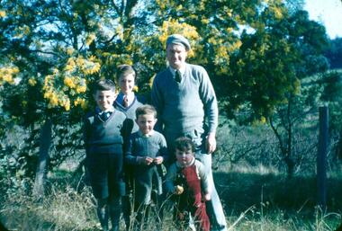
Photograph - Digital Image, Looking north east to the orchard at Blackjack, 1954_
Looking north east to the orchard at Blackjack. The Robinson family (left to right): James, Peter, Paul, Andrew and father Frank. The Blackjack property, house and acres of fruit orchards ran down to the Plenty River off Hume Street Greensborough and was the home of the Robinson family to late 1956. The photographs were taken as slides by Frank Robinson and digitised by his son James in 2015.Digital copy of colour photograph.blackjack, robinson family -
 Greensborough Historical Society
Photograph - Digital image, Marilyn Smith et al, Janefield Precinct: Old fence line, and, retained earth on fence line, 27/11/2014
Janefield Precinct: Old fence line, and retained earth on fence line. The remains of this site are between Greensborough and Janefield. A RAAF Hygiene Training Camp was located on the Plenty River, just south of the Janefield community. It was in use from 1944 to 1946. The Camp was constructed from salvaged materials. Instruction included building and maintenance of grease traps, latrines, elementary plumbing and carpentry.Early remains of a WW2 training camp 2 Digital colour photographs. -
 Greensborough Historical Society
Photograph - Digital image, Marilyn Smith et al, Janefield Precinct: Old shed base, outline, spoon drain and post holes, 27/11/2014
Janefield Precinct: Old shed base, outline, spoon drain and post holes. The remains of this site are between Greensborough and Janefield. A RAAF Hygiene Training Camp was located on the Plenty River, just south of the Janefield community. It was in use from 1944 to 1946. The Camp was constructed from salvaged materials. Instruction included building and maintenance of grease traps, latrines, elementary plumbing and carpentry.Early remains of a WW2 training camp 4 Digital colour photographs. -
 Greensborough Historical Society
Photograph - Digital image, Marilyn Smith et al, Janefield Precinct: View of slab from below showing formwork marks, 27/11/2014
Janefield Precinct: View of slab from below showing formwork marks. The remains of this site are between Greensborough and Janefield. A RAAF Hygiene Training Camp was located on the Plenty River, just south of the Janefield community. It was in use from 1944 to 1946. The Camp was constructed from salvaged materials. Instruction included building and maintenance of grease traps, latrines, elementary plumbing and carpentry.Early remains of a WW2 training camp Digital colour photograph.janefield -
 Greensborough Historical Society
Photograph - Digital image, Marilyn Smith et al, Janefield Precinct: World War 2 era concrete admin block, 27/11/2014
Janefield Precinct: World War 2 era concrete admin block. The remains of this site are between Greensborough and Janefield. A RAAF Hygiene Training Camp was located on the Plenty River, just south of the Janefield community. It was in use from 1944 to 1946. The Camp was constructed from salvaged materials. Instruction included building and maintenance of grease traps, latrines, elementary plumbing and carpentry.Early remains of a WW2 training camp Digital colour photograph.janefield -
 Greensborough Historical Society
Photograph - Digital image, Marilyn Smith et al, Janefield Precinct: World War 2 era admin toilet block, 27/11/2014
Janefield Precinct: World War 2 era admin toilet block. The remains of this site are between Greensborough and Janefield. A RAAF Hygiene Training Camp was located on the Plenty River, just south of the Janefield community. It was in use from 1944 to 1946. The Camp was constructed from salvaged materials. Instruction included building and maintenance of grease traps, latrines, elementary plumbing and carpentry.Early remains of a WW2 training camp Digital colour photograph.janefield -
 Greensborough Historical Society
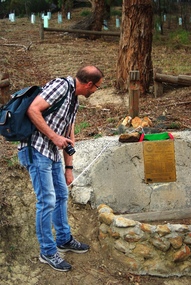
Photograph - Digital image, Marilyn Smith, Unveiling of new plaque at the Pioneer Children's Cemetery, April 2016, 02/04/2016
On 02/04/2016, Greensborough Rotary and Greensborough Hstorical Society members gathered to unveil an updated plaque at the Pioneer Children's Cemetery on the Plenty River. These photos show the new plaque and Steve Whatmough viewing the plaque. Steve is a descendant of the Whatmough family whose children, with their cousins the Partingtons, were buried in this place. More photos of this event can be found at the GHS Resource Centre. Digital copy of colour photograph.greensborough historical society, pioneer childrens cemetery, steve whatmough, rotary club of greensborough -
Glenelg Shire Council Cultural Collection
Functional object - Lifebuoy, n.d
City of Portland Collection|Kurtze Museum|19/4/2000. The lifebuoy came from the S S Casino. A popular cargo ship, the Casino was a regular sight on the Moyne river and along the coast. The ship was an integral part of coastal life until she was shipwrecked in the 1930's, and objects from the Casino can now be found in collections from across the region.S S CasinoCanvas covered ring of bouyant material (possibly cork), with rope loop fixed to 4 ponts on the outside edge. Inscription "S.S. CASINO" centre top, "PORT FAIRY" at centre bottom, a flag painted centre left and centre right.Front: Centre top "S. S. CASINO"|Centre bottom "PORT FAIRY"|flag on centre left and centre rightss casino, port fairy, cargo ship, lifebuoy -
 Eltham District Historical Society Inc
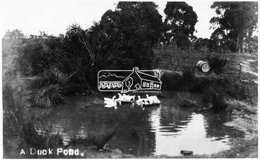
Photograph, Tom Prior, A Duck Pond, c.1900
The location was Fernie Hill where Ivy Reynolds's mother was born, over from Mr Traill's property at the corner of Reynolds and Main Road, Research - used to be called 3 Chain Road, now renamed Gumtree Road. The old Yarra River bed goes through here at top of hill in Gumtree Road. Gravel from this location was used for the driveways in Government House.This photo forms part of a collection of photographs gathered by the Shire of Eltham for their centenary project book,"Pioneers and Painters: 100 years of the Shire of Eltham" by Alan Marshall (1971). The collection of over 500 images is held in partnership between Eltham District Historical Society and Yarra Plenty Regional Library (Eltham Library) and is now formally known as the 'The Shire of Eltham Pioneers Photograph Collection.' It is significant in being the first community sourced collection representing the places and people of the Shire's first one hundred years.Digital image 4 x 5 inch B&W Negsepp, shire of eltham pioneers photograph collection, eltham, duck pond, reynolds prior collection, pond, fernie hill, gumtree road, research (vic.) -
 RSL Victoria - Anzac House Reference Library and Memorabilia Collection
Diary of William John Stephenson
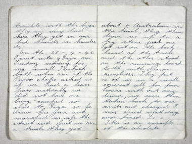
Stephenson departed Melbourne on 3 September 1941 onboard the Queen Mary. Diary runs from departure date until September 1 1942, covering Stephenson's Middle East service and his wounding in action at Alamein. One year later, Stephenson was wounded in action at Buiem River in New Guinea, and a few days later died from the wounds received.WW 2 diary of William Stephenson (VX 51713 2/23 Battalion).william john stephenson, ww11, 2/23 battalion, diaries -
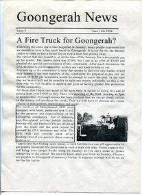 Orbost & District Historical Society
newsletters, Goongerah Grapevine, July 1998 - August 2005
Goongerah is a community on the Brodribb River, located in Gippsland, about seventy kilometres north of Orbost. The town's population is about sixty. Goongerah Post Office opened on 21 November 1952 and closed in 1974. Goongerah had one of the smallest primary schools in Victoria, with about 11 students. The school no longer functions. These newsletters were produced by members of the community and distributed locally.In small rural communities newsletters have been important tools for facilitating community development while fostering a sense of belonging and attachment to the community.A yellow plastic covered folder containing black / white printed newsletters. There are fifteen copies of "Goongerah Community News" and thirty-nine copies of "Goongerah Grapevine". All include news from the C.F.A., Forest News and articles from Goongerah Primary School.label on front- "COMMUNITY NEWSLETTERS Goongerah 1998 - 2005" -
 Eltham District Historical Society Inc
Photograph, Amberley, Lower Plenty; Autumn Excursion to Lower Plenty area, 18 April 1998, 18/04/1998
Looking westerly across the Yarra from Westerfolds Park you can see a large and imposing building at the top of the escarpment above the river. This is the Christian Brothers Training Centre at Lower Plenty and known as Amberley. This significant building dates from 1930 when it was the rather grand residence of Oswald Darch. It was purchased by the Catholic Church in 1955 and has since been significantly extended.Roll of 35mm colour negative film, 2 stripsKodak Gold 200-6activities, lower plenty, amberley -
Federation University Historical Collection
Booklet - Document, Robert Ashley et al, 'The Lal Lal Iron Tramway', 1970
High on a series of terraces overlooking the Moorabool River stands the remains of the Lal Lal Blast Furnace, classified 'A' by the National trust (to be preserved at all costs). This was the location of Victoria's only pig iron industry. A series of tramways served the works, as a well surveyed narrow-gauge tramway connected the blast furnace with the Victorian Roailways' main line about 3.5 miles away. Light Railways, no 24, Summer 1970-71, 36 pages. This booklet considers the Lal Lal Iron Tramwaylal lal iron, lal lal blast furnace, tramways, railways, pig iron, ironstone quarry, industrial heritage -
Port Melbourne Historical & Preservation Society
Pamphlet - Beacon Cove to Webb Trail 2016, Pat Grainger, Walks around Vintage Port No.6, Jun 2016
Walks Around Vintage Port No 6. Supported by CoPP. Walk No 6 was originally reserved for Bend on the River: Westgate Park. The Westgate Park walk was not produced so the updated versions the Pub walk in 2001 and 2012 became No 6 however with the introduction of this Beacon Cove to Webb Trail as a new Walk No 6 in 2016, the 2017 version of the Pub walk reverted to No 7.Port Melbourne Historical and Preservation Society publication, "Walks around Vintage Port", No.6 Beacon Cove to Webb Trail 2016 Editionbuilt environment, piers and wharves - webb dock, beacon cove -
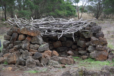 Ballarat Heritage Services
Photograph - Colour, Aboriginal Rock Hut recreations at Tyrendarra, 2016, 16/04/2016
The Budj Bim National Heritage Landscape - Tyrendarra Area on the Australian National Heritage List lies on the Tyrendarra lava flow between the Fitzroy River and Darlot Creek close to the township. The Budj Bim Cultural Landscape was ascribed on the UNESCO World Heritage List on 06 July 2019 (AEST). These photographs were taken during a guided tour with Gunditjmara guide Dennis Rose.Remains of stone shelters built and used by the Gunditj Mirring people.rock shelter, aboriginal, aborigines, tyrendarra, winda mara, rock hut, gunditjmara, unesco world heritage -
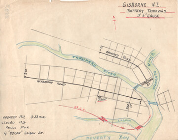 Ballarat Tramway Museum
Drawing - Gisborne NZ - Battery Tramway - plan, Wal Jack, c1946
Wal Jack had an extensive range of correspondents throughout Australia and the world who often provided him with detailed drawings and notes on various tramway systems. This drawing shows the small battery-powered (four) tramcar system in Gisborne NZ. Shows the NZ rail line, rivers and the length of each route, and the dates of operation. Based on the handwriting, prepared by Wal Jack himself. Yields information about Wal Jack's extensive recording and research work.Drawing - black, red and blue ink or colour pencil on quarto size paper of the Gisborne NZ tramway system.tramways, wal jack, drawings, maps, tramcars, gisborne nz -
 Kew Historical Society Inc
Photograph - 8 Kellett Grove, North Kew, 1929
North Kew, now divided between Kew and Kew East, bordered the Yarra River. As such, it was a region subject to flooding in the Yarra Valley. Development beyond this point (ie Kellett Grove) was limited by the City of Kew's planning regulations. Prior to urban development, the area since European settlement and the first land sales in the district in the 1840s, had been used for dairy farming. Small sepia snapshot taken of the front of 8 Kellett Grove, in what was then known as North Kew. Verso: 8 KELLETT GROVE / NORTH KEW / 1929 / 418 kellett gove -- north kew, californian bungalows, houses -- kellett grove -- kew (vic.) -
 Kew Historical Society Inc
Photograph - Flooding of the Yarra River in North Kew, 1934
North Kew, now divided between Kew and Kew East, bordered the Yarra River. As such, it was a region subject to flooding in the Yarra Valley. Development beyond this point (ie Kellett Grove) was limited by the City of Kew's planning regulations. Prior to urban development, the area since European settlement and the first land sales in the district in the 1840s, had been used for dairy farming. Small sepia snapshot taken from the back yard of a house at 8 Kellett Grove, in what was then known as North Kew. The point of view is from a backyard looking towards Fairfield. Floodwaters have submerged the fence and a clothes line. Verso: BACKYARD NTH. KEWyarra river -- north kew, floods -- yarra valley, floods -- north kew, floods -- 1934, natural disasters -- kew