Showing 7098 items matching "snowy-river"
-
 Bendigo Historical Society Inc.
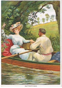
Document - MALONE COLLECTION: GREETING CARDS, 22/1/1910
Coloured picture of a lady & a man in a rowing boat. The lady is wearing a light blue dress and floral hat. Sh is holding a tree branch that is hanging over the water. She has a red rug behind her. The man is wearing white shirt & trousers with a pink belt. There is a blue rug beside him. There is tree and reeds along the edge of the water and open grassland behind them. Printed on front is 'Horner's Penny 'River of Life' Series No 2. 22.1.1910. Written on the back in ink is: M.P. 275. The picture is titled 'Betrothed'.M. P. 275personal effects, greeting cards, malone collection, malone collection, greeting cards, horner's penny stories 'river of life' series no 2 -
 Bendigo Historical Society Inc.
Document - NORMAN OLIVER COLLECTION: MAYOR SPEAKS 1 MAY 1965
The Norman Oliver collection. Norman Oliver was three times Mayor of Bendigo - 1950-51, 1964-65, 1970-71. Three typed pages titled 'Mayor Speaks', with the date in black ink across the top of the first page - 1/5/65. Topics include : the Central Plant Depot of the State Rivers and Water Supply Commission at Golden Square, BLB Corporation, invitations to the Mayoral Ball, opening ceremony of Golden Square High School, need for development and improved organisation with sporting facilities for girls, and street lighting.bendigo, council, report, norman joseph oliver , councillor norman oliver. mayor of bendigo. b.l.b. corporation. central plant depot. -
 Ballarat Tramway Museum
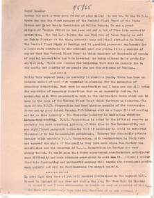
Photograph - Black & White Photograph/s, Negative, Ellis Collection, c1950
Yields information about the appearance of Bridge St and the use of the trams c1950.Black and white photograph of a bogie tram 22 west bound in Bridge St. Has a group of ladies on either side of the road waiting to board? Note the signs on the poles on either side of the roadway. Has the Waratah Motors, Roger David stores on the west side of the street. c1950. Note the road lifting over the Yarrowee River bridge. The two signs on either side of the road "No Parking over 1 hour Park 1 Foot from kerb" Negative number 1140. Negative scanned at 2400dpi. On the top edge of one of the prints "same as 1094"trams, tramways, ballarat, bridge st, signs, tram 22 -
 Bendigo Historical Society Inc.
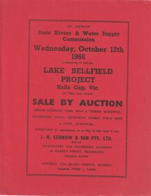
Document - IAN DYETT COLLECTION: AUCTION CATALOGUE - LAKE BELLFIELD PROJECT
Two copies of red covered auction catalogue for sale on account of State Rivers & Water Supply Commission held on 12/10/1966 Lake Bellfield Project, Hall Gap, Vic. Lots include motor vehicles, corr. Iron & timber buildings, machinery, tools, equipment, stores, scrap iron & steel and furniture. J. H. Curnow & son Pty. Ltd. Were the auctioneers. Catalogue has a map from Melbourne & Geelong to site near Hall's Gap and an Auction Layout sketch.business, auctioneers, j h curnow & son pty ltd, ian dyett collection - auction catalogue - lake bellfield project, state rivers & water supply commission, j h curnow & son pty ltd, f c dyett, l c osborne, c hill -
 Kew Historical Society Inc
Archive (Sub-series) - Subject File, DAKIN Family, 1958
Various partiesReference, Research, InformationSecondary Values (KHS Imposed Order)Subject file containing information on the Dakin family of Kew, whose sons attended Trinity Grammar School. Jane Carolan, the archivist of Trinity Grammar School, compiled the research notes. The information in the file relates to Arthur William Dakin and Frances E Dakin. Jane Carolan’s research covers the period 1904-1950. Robert Baker used the notes to develop a newsletter article on the Kew High School trophy won by Arthur Dakin. [Arthur Dakin was later a member of the Ross River Rescue Mission of 1917.]arthur dakin, kew high school, trinity grammar school, ross river rescue mission, frances dakinarthur dakin, kew high school, trinity grammar school, ross river rescue mission, frances dakin -
 Kew Historical Society Inc
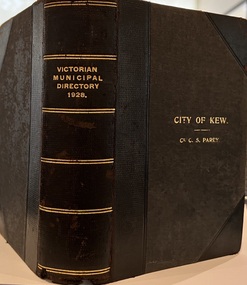
Journal, Arnall & Jackson: Printers & Stationers, Victorian Municipal Directory and Gazetteer : Also Commonwealth Guide and the Water Supply Record for 1928
The Victorian Municipal Directory provided annual details, and later bi-annual details, of all councils. Published by Arnall & Jackson (Printers and Stationers), copies were published in 'cloth' for sixteen shillings and 'half roan' for eighteen shillings. This copy was owned by Cr C.S.Parry. Elected to the Kew City Council as a representative of North Ward, Cr Parry was elevated to the position of Mayor in 1931. It, together with five other editions, was presented to the Kew Historical Society in 1987 by his grandson.Bound copy of the Victorian Municipal Directory and Gazetteer: Also Commonwealth Guide and the Water Supply Record for 1928. The volume contains 846 pages and includes sections on: - Comparative table – Municipal Returns for Twenty-one Years. - Index to Townships, Parishes and Railway Stations. - Changes and appointments. - Commonwealth of Australia (Constitution, Parliament, Departments and Officers). - State of Victoria (Parliament, Departments and Officers / Boards, Institutions, Trusts and Loans). - Municipalities in Victoria (Cities and Towns, Boroughs, Shires). - Water Supply (State Rivers and Water Supply Commission).non-fictionThe Victorian Municipal Directory provided annual details, and later bi-annual details, of all councils. Published by Arnall & Jackson (Printers and Stationers), copies were published in 'cloth' for sixteen shillings and 'half roan' for eighteen shillings. This copy was owned by Cr C.S.Parry. Elected to the Kew City Council as a representative of North Ward, Cr Parry was elevated to the position of Mayor in 1931. It, together with five other editions, was presented to the Kew Historical Society in 1987 by his grandson. victoria -- registers -- periodicals., victoria -- directories., water-supply -- victoria -- directories., municipal government -- victoria -- periodicals., cities and towns -- victoria -- directories. -
 Kew Historical Society Inc
Photograph - Marysville, c.1926
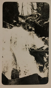
Henry Beater Christian (1886-1962) , was a descendant of one of the earliest settler families in Kew. Employed at the Kew Asylum as a 'public servant', he was a skilled amateur photographer, photographing numerous scenes in Kew and on his travels around Victoria. The majority of his photographs date from 1916 to 1929. His finest photographs are housed in two photograph albums. Digital copy of a photograph from page 20 of the 47-page photograph album containing 261 gelatinous silver images, loaned by Diane Washfold with permission given to digitise and hold a copy in our collection. This photograph, dating from c.1926, forms part of a group of photos taken on a bushwalking trip to Marysville, Victoria. John Chapman has written in 'Bushwalking Clubs - A Brief History', about the establishment in Victoria of the first bushwalking club in 1888, and the popularisation of bushwalking during the interwar period. This photograph is of a waterfall on the Steavenson River.henry beater christian (1886-1962), landscape photography, kew (vic.) — yarra river, christian-washfold collection, photograph albums, bushwalking -- victoria, marysville (vic.) -
 Kew Historical Society Inc
Photograph - Marysville, c.1926
Henry Beater Christian (1886-1962) , was a descendant of one of the earliest settler families in Kew. Employed at the Kew Asylum as a 'public servant', he was a skilled amateur photographer, photographing numerous scenes in Kew and on his travels around Victoria. The majority of his photographs date from 1916 to 1929. His finest photographs are housed in two photograph albums. Digital copy of a photograph from page 20 of the 47-page photograph album containing 261 gelatinous silver images, loaned by Diane Washfold with permission given to digitise and hold a copy in our collection. This photograph, dating from c.1926, forms part of a group of photos taken on a bushwalking trip to Marysville, Victoria. John Chapman has written in 'Bushwalking Clubs - A Brief History', about the establishment in Victoria of the first bushwalking club in 1888, and the popularisation of bushwalking during the interwar period. This photograph is of a waterfall on the Steavenson River.henry beater christian (1886-1962), landscape photography, kew (vic.) — yarra river, christian-washfold collection, photograph albums, bushwalking -- victoria, marysville (vic.) -
 Kew Historical Society Inc
Photograph - River, c.1927
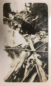
Henry Beater Christian (1886-1962) , was a descendant of one of the earliest settler families in Kew. Employed at the Kew Asylum as a 'public servant', he was a skilled amateur photographer, photographing numerous scenes in Kew and on his travels around Victoria. The majority of his photographs date from 1916 to 1929. His finest photographs are housed in two photograph albums. Digital copy of a photograph from page 26 of the 47-page photograph album containing 261 gelatinous silver images, loaned by Diane Washfold with permission given to digitise and hold a copy in our collection. John Chapman has written in 'Bushwalking Clubs - A Brief History', about the establishment in Victoria of the first bushwalking club in 1888, and the popularisation of bushwalking during the interwar period. Henry Christian's 'walks' appear to have been undertaken solely or with a companion/s. Here the photographer takes a snapshot of a river that he passed.Inscription on page illegiblehenry beater christian (1886-1962), landscape photography, christian-washfold collection, photograph albums, bushwalking -
 Kew Historical Society Inc
Photograph - Bridge, c.1927
Henry Beater Christian (1886-1962) , was a descendant of one of the earliest settler families in Kew. Employed at the Kew Asylum as a 'public servant', he was a skilled amateur photographer, photographing numerous scenes in Kew and on his travels around Victoria. The majority of his photographs date from 1916 to 1929. His finest photographs are housed in two photograph albums. Digital copy of a photograph from page 26 of the 47-page photograph album containing 261 gelatinous silver images, loaned by Diane Washfold with permission given to digitise and hold a copy in our collection. John Chapman has written in 'Bushwalking Clubs - A Brief History', about the establishment in Victoria of the first bushwalking club in 1888, and the popularisation of bushwalking during the interwar period. Henry Christian's 'walks' appear to have been undertaken solely or with a companion/s. Here the photographer takes a wooden bridge across a river.Inscription on page illegiblehenry beater christian (1886-1962), landscape photography, christian-washfold collection, photograph albums, bushwalking -
 Kew Historical Society Inc
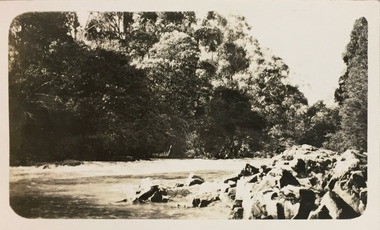
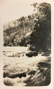
Photograph - River, c.1927
Henry Beater Christian (1886-1962) , was a descendant of one of the earliest settler families in Kew. Employed at the Kew Asylum as a 'public servant', he was a skilled amateur photographer, photographing numerous scenes in Kew and on his travels around Victoria. The majority of his photographs date from 1916 to 1929. His finest photographs are housed in two photograph albums. Digital copy of a photograph from page 26 of the 47-page photograph album containing 261 gelatinous silver images, loaned by Diane Washfold with permission given to digitise and hold a copy in our collection. John Chapman has written in 'Bushwalking Clubs - A Brief History', about the establishment in Victoria of the first bushwalking club in 1888, and the popularisation of bushwalking during the interwar period. Henry Christian's 'walks' appear to have been undertaken solely or with a companion/s. Here the focus of the photograph is rapids in a river.Inscription on page illegiblehenry beater christian (1886-1962), landscape photography, christian-washfold collection, photograph albums, bushwalking -
 Kew Historical Society Inc
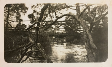
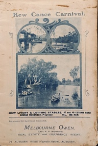
Programme, Kew Canoe Carnival, 1910
An item from an outstanding and diverse photographic collection, assembled by members of the Christian and Washfold families of Kew.Rare programme for what was once an annual event in Kew with important, possibly unique photos of sites in Kew and on the Yarra.Programme for the 1910 Kew Canoe Carnival which was held on the River Yarra on February 11th. The location was at the Asylum Reserve at the old white bridge (the precursor of Kane's Bridge). Funds were raised in Aid of the Annual Treat to Kew and Yarra Bend Patients (and the Carnival fund). The booklet includes details of the programme, numerous advertisements and rare and important historic photographs of the district including: the Willsmere Park Dairy, the Glen Tea Gardens at Hawthorn, the Pipe Bridge, the Kew Boat Sheds (Macauley's), and Rudder Grange boat house.christian-washfold collection, kew canoe club, kew canoe carnivals -
 Kew Historical Society Inc
Map, MMBW, MMBW Plan No.39 Kew & Heidelberg, 1900-1910
The Melbourne and Metropolitan Board of Works (MMBW) was established by an act of the Victorian Parliament in 1890 to prepare for and to implement a sewerage and water reticulation system across what was then inner Melbourne, its surrounding and middle distance suburbs, including Kew. The MMBW was disbanded in 1991.The map collection of the Kew Historical Society has at its core the historic maps assembled and originally stored in the City Engineer's Department of the City of Kew. These include maps in a number of scales. The vast majority of maps were produced by the MMBW in the first two decades of the twentieth century, and are solid working maps, backed by linen for durability. These maps are historically significant to Kew, the City of Boroondara and to the history of the development of state utilities in Victoria. A number of the Kew maps have additional details added by former municipal officers, including the levels reached by various floods. As these were working documents, information was added to them long after the period of their initial production and distribution.Early map of part of the Borough of Kew, created in the first decade of the twentieth century, at a scale 160 ft to 1 inch. The map covers what was then the north western section of Kew, bordered on its north by Wills Street and the Kew Lunatic Asylum, in the west by the River Yarra [and the later added Yarra Boulevard] , by Princess Street in the East and Holroyd Street in the south. The map shows the extent of urban development by that time, prominent institutions and the outlines of built structures in the municipality. Contour lines were added in ink to the map at a later stage.MELBOURNE AND METROPOLITAN BOARD OF WORKS / PLAN NO. 39 / KEW & HEIDELBERGmelbourne & metropolitan board of works, mmbw maps, mmbw plans, borough of kew, cartography -
 Kew Historical Society Inc
Map, MMBW, MMBW Plan No.68 Kew, 1900-1910
The Melbourne and Metropolitan Board of Works (MMBW) was established by an act of the Victorian Parliament in 1890 to prepare for and to implement a sewerage and water reticulation system across what was then inner Melbourne, its surrounding and middle distance suburbs, including Kew. The MMBW was disbanded in 1991.The map collection of the Kew Historical Society has at its core the historic maps assembled and originally stored in the City Engineer's Department of the City of Kew. These include maps in a number of scales. The vast majority of maps were produced by the MMBW in the first two decades of the twentieth century, and are solid working maps, backed by linen for durability. These maps are historically significant to Kew, the City of Boroondara and to the history of the development of state utilities in Victoria. A number of the Kew maps have additional details added by former municipal officers, including the levels reached by various floods. As these were working documents, information was added to them long after the period of their initial production and distribution.Early map of part of the Borough of Kew, created in the first decade of the twentieth century, at a scale 160 ft to 1 inch. The map covers what was then the north central part of Kew, bordered in the north by Oak Avenue, in the west by the Yarra River and Connor's Creek, in the south by Beresford and Carnegie Avenues, and in the east by Glass's Creek and Burke Road. The map shows the extent of urban development by that time, prominent institutions and the outlines of built structures in the municipality. Contour lines and the levels of historic floods were added in ink to the map at a later stage.MELBOURNE AND METROPOLITAN BOARD OF WORKS / PLAN NO. 68 / KEW melbourne & metropolitan board of works, mmbw maps, mmbw plans, borough of kew, cartography -
 8th/13th Victorian Mounted Rifles Regimental Collection
Photograph
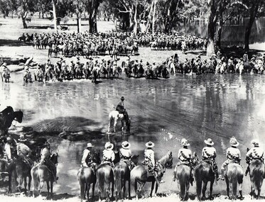
A rare photograph of massed Light Horse in Victoria shortly before mechanisation consigned the horse to history.Black and white photograph of large group of horsemen in ranks waiting in the process of watering horses at a lagoon. One copy of the image claims it to be 8th Light Horse Regiment watering horses at a Murray River lagoon, South Corowa NSW, September 1939; Wahgunyah Troop, C Squadron - this side of lagoon, Lieutenant J. Nott on grey horse in water. A second copy (Cat No 0690) asserts it is 4 regiments of light horse being 8th, 13th, 20th and 4th watering horses near Torquay Victoria, March 1940.On a label on reverse of 0690: "Picture taken about March 1940 when the 13th Light Horse from Gippsland, the 8th Light Horse from Upper Murray, the 4th Light Horse from the Western Districts and the 20th Light Horse from the Goulburn Valley were in camp near Torquay. Mr Cappur Webb of Glendoxey, Seymour, a member of the 20th said the picture must have been taken during and exercise about five miles north of Torquay. “We used to water our horses in that lake”, he said." -
 University of Melbourne, Burnley Campus Archives
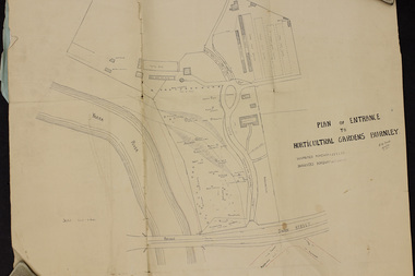
Plan, Plan of Entrance to Horticultural Gardens Burnley, 1932
Copy of plan photographed at the Public Records Office Victoria. (1) Hand drawn plan signed by A.W. Jessep 8/12/32 with 'Suspected Roadway' and ' Suggested Roadway'. Scale 1 inch - 1 chain. Trees on East side named. (2) Memorandum to The Agricultural Superintendent dated 08.12.1932 'Re Proposed Boulevard Along the River Yarra' from the Principal A.W. Jessep. Plan had been to put road through the Lagoon Paddock and he suggested the route outside the Burnley College grounds.prov, burnley gardens, a.w. jessep -
 National Vietnam Veterans Museum (NVVM)
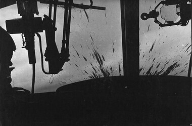
Photograph, Gibbons, Denis, The Playboys 2
Denis Gibbons (1937 – 2011) Trained with the Australian Army, before travelling to Vietnam in January 1966, Denis stayed with the 1st Australian Task Force in Nui Dat working as a photographer. For almost five years Gibbons toured with nine Australian infantry battalions, posting compelling war images from within many combat zones before being flown out in late November 1970 after sustaining injuries. The images held within the National Vietnam Veterans Museum make up the Gibbons Collection.A black and white photograph of a Huey Gunship from the 1st Platoon 334th Armed Helicopter with its windscreen sprayed with mud from the explosion after firing two rockets into a VietCong sampan, loaded with explosives and ammunition attempting to enter South Vietnam down the Mekong River from Cambodia. The sampan was blown to pieces with all on board being killed and the force of the explosion pushing the nose of the helicopter upwards. nearly turning the aircraft over. The pilot had to fight the controls to regain a normal flying attitude.photograph, 1st platoon, 334th armed helicopter coy, huey helicopter, the playboys, mekong river, cambodia, gibbons collection catalogue, denis gibbons, photographer, vietnam war, vietcong, sanpan -
 Melbourne Tram Museum
Slide - Set of 2, Keith Caldwell, 10/03/1960 12:00:00 AM
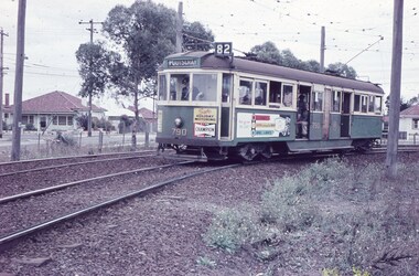
Set of 2 Agfa Colour slide, cardboard mount, by Keith Caldwell of 10 March 1960 - .1 - W5 790, turning on Rosamond Road Maribyrnong into River St, destination of Footscray, Route 82. Tram has the adverts for Champion spark plugs and a recruiting advert for MMTB Conductors. .2 - W5 790 returning, photographed in Rosamond Road, destination Moonee Ponds, Route 82. Has an adverts for Knight? and Tulip? Note the cattle guard on the level crossing and the "Trams No Road Only" and "No Road" signs.All hand stamped "10 Mar '60". .1 - marked "Footscray Connection"trams, tramways, maribyrnong, footscray, rosamond rd, river st, level crossings, w5 class, route 82, moonee ponds, tram 790 -
 Melbourne Tram Museum
Negative, Wal Jack, c1955
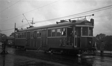
Black and white negative, by Wal Jack, of W2 257 after a collision with a large vehicle. Has part of the front saloon stowed in, footboard and grab handles torn away. Tram has the destination of Spencer St, route 27?. Appears to be in Bridge Road with the river in the background - see also Reg Item 5171 for another photo in Wellington Parade, near Simpson St Photo Wal Jack on a very wet day. Dated 20/4/1951 in the Ray Pearson Album, photographed in Wellington Parade.trams, tramways, w2 class, wellington parade, accidents, route 27, tram 257 -
 Bendigo Historical Society Inc.
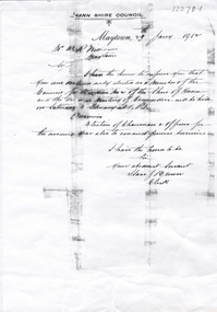
Document - ALMOND ROWE WILLIAMS COLLECTION: COPY OF LETTER
Copy of letter from the Hann Council, January 1909, regarding Almond Williams election to the Shire of Hann, Maytown Council. Hann Shire (1879-1919) was the local government area for the Palmer River goldfield, between 70 km and 150 km west of Cape Tribulation. Access from the coast was via Cooktown, 100 km to the north-east. In 1872 an expedition led by William Hann explored the interior of Cape York Peninsula. Presumably, Almond Williams went to the Palmer field after his time in Bendigo.bendigo, mining, almond williams -
 Warrnambool and District Historical Society Inc.
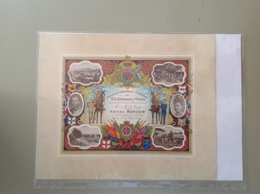
Certificate - Royal Review 1901 G Rolfe, 1901
This certificate was sent to those who had been present at one of the celebrations in connection with the Federation of the six States of Australia in 1901 – The Royal Review at Flemington Racecourse on 10th May 1901. The invitation to attend the event was issued by the Government of Victoria. The certificate was intended to be kept as a souvenir of the event and framed. This particular certificate was issued to George Rolfe and his wife of Warrnambool. George Rolfe (1836-1919), a tea merchant from Melbourne, began buying blocks of land near the mouth of the Hopkins River in Warrnambool in the 1870s. By the early 1880s he had acquired 50 acres of land in the town and several farming properties. He used the buildings on the land near the mouth of the Hopkins River as holiday accommodation and called the property, Lyndoch. He improved the property by adding stables, chaff and bone sheds, jetty, boathouse, reservoir, water well and windmill and extensive gardens and he spent most of his later life in the Warrnambool area. Lyndoch today is the site of an aged care facility. This certificate is of considerable importance for two reasons: 1. It is an important memento of a signal event on Australia’s history – the Federation of the six States in 1901 and the subsequent celebrations. 2. The certificate was issued to a prominent Warrnambool person, George Rolfe and his wife.This is multi-coloured sheet of paper mounted on card. There are four black and white photographs of the Royal Review at Flemington and photographs of the Duke and Duchess of Cornwall and York. The images include the Royal Crest, the shields of the six Australian States, a shield of Victoria with a background of flags, cannon and ammunition, two mounted soldiers with a soldier and sailor standing nearby and swords and bayonets. There is also much colour decoration around the edges of the certificate. The names of Mr and Mrs Rolfe are handwritten in black ink. ‘Australian Commonwealth Celebrations’ ‘The Government of Victoria requests the honour of the presence of Mr & Mrs G. Rolfe at the Royal Review at Flemington on Friday the 10th of May 1901’ federation of australian states, george rolfe of lyndoch, history of warrnambool, george rolfe -
 Warrnambool and District Historical Society Inc.
Certificate, Duke of Cornwall
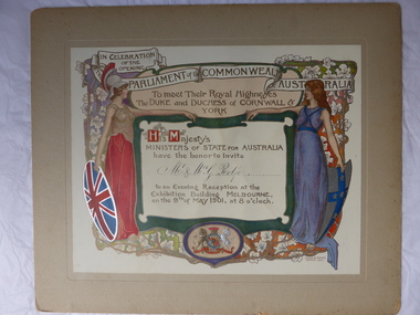
This certificate is an invitation to the Evening Reception in Melbourne in 1901, an event which was part of the celebrations in Melbourne to commemorate the Federation of the six colonies into the six States of Australia in January 1901. The certificate was sent to the invitees after the event as a souvenir of the occasion. The certificate was designed by the artists Julian and Howard Ashton and lithographed and issued by Sands and McDougall Limited of Melbourne. This particular certificate was sent to George Rolfe and his wife Annie. George Rolfe (1836-1919), a tea merchant from Melbourne, began buying blocks of land near the mouth of the Hopkins River in the 1870s. By the early 1880s he had acquired 50 acres of land in the town and several nearby farming properties. He used the buildings on the land at the mouth of the River Hopkins as holiday accommodation and called this property Lyndoch. Rolfe improved this property adding stables, jetty, boathouse, bone and chaff sheds, reservoir and windmill and extensive gardens. Rolfe spent most of his later life at Lyndoch. Today the property is the site of an Aged Care Facility. This certificate is of considerable importance for two reasons: 1. It is an attractive and valuable memento of a signal event in Australia’s history – the Federation of the States in 1901. 2. The certificate was an invitation to Mr and Mrs George Rolfe. Rolfe was a prominent person in Warrnambool in the late 19th and early 20th centuries. This is a multi-coloured certificate mounted on a piece of grey cardboard. The certificate is highly embossed and has a figure of Britannia in a red dress and a mailed vest holding a shield with the Union Jack emblem. Britannia is extending her hand to a figure of a younger woman representing Australia. This figure is dressed in blue and holds a shield which has a blue cross with white stars. The borders have vines and vine leaves and the Royal Crest is at the base of the certificate. The names of the invitees are handwritten in black ink. ‘In Celebration of the Opening of the Parliament of the Commonwealth of Australia, To Meet Their Royal Highnesses, the Duke and Duchess of Cornwall and York, His Majesty’s Ministers of State for Australia have the honor to invite Mr & Mrs G. Rolfe to an Evening Reception at the Exhibition Building, Melbourne on the 9th of May 1901, at 8 0’clock’. george rolfe of lyndoch, warrnambool, federation of australia, history of warrnambool, george rolfe -
 Kiewa Valley Historical Society
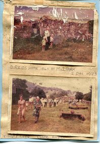
Photographs x 2- D Reids home at Mill Park 1973, 2/12/1973
David Reid (1820-1906) was a pastoralists and politician. He left school at 16 and after meeting the overlander John Gardiner he decided to look for land south of the Murray River. Equipped by his father with some 500 head of cattle, 2 bullock wagons and teams and 6 assigned servants, he reached the Ovens River on 8 September 1838. David settled at Currargarmonge, near Wangaratta. At the end of 1843 he took up land near Yackandandah. In 1847 he took up a section of the family run of which Woorajay (Wooragee) formed a part. He built the first water driven flour-mill in the district on his Yackandandah run in 1845; his woolclip of 1848 was one of the first to be handled by R. Goldsbrough and was claimed to come from sheep descended from stock imported in the 1820s from George III's flock. Going into politics, he held the Legislative Assembly seat of Murray from October 1859 to May 1862. David Reid was a highly regarded grazier and local politician who was significantly involved in settlement around the Yackandandah area. Photo demonstrates ongoing interest in the local history of the area and its early residents2 colour photographs mounted together on buff card 1. Man and 2 children (unidentified) standing outside the remains of the Reid home. 2 Dec, 1973 2. Group of unidentified people on a tour of the old homestead of D. Reid. 2 Dec, 19731. Handwritten in black ink under photo 'D. Reid's home 1845. At Mill Park. 2 Dec 1973 2. Handwritten in blue ink under photo 'Snapshots Clare Roper"clare roper -
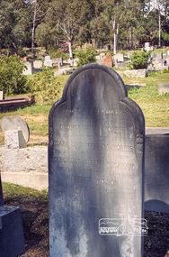 Eltham District Historical Society Inc
Negative - Photograph, Harry Gilham, Morris family grave, Eltham Cemetery, Victoria, Sep 2009
On 29 January 1842, John Morris, aged 24 (a bonded convict transported for 15 years aboard the Earl Grey) was married to Jane Elliott (a free person) by the Rev A.C. Thomson in Melbourne. John and Jane were the parents of Jane (1843 Heidelberg), Mary Ann (1845 Plenty River), John (1847 Plenty River), William (Little Eltham 1851), Elizabeth (Little Eltham 1852), Thomas Alfred (Eltham 1856), George Hill (Eltham 1859), Margaret Ellen (Eltham 1861) and Clara Lucy Matilda (Eltham 1864) In Memory of Thomas Alfred Morris Died 10th July 1884 aged 28 years George Hill Morris Died 13th August 1885 aged 25 years Clara Lucy Matilda Morris Died 5th Feb. 1885 aged 20 years Margaret Ellen Wickham Died Feb 7th 1884 aged 22 years Harriet Wilson Died Feb. 12th 1874 aged 33 yearsRoll of 35mm colour negative film, 6 stripsKodak GC 400-9eltham cemetery, gravestones, jane morris, john morris, mary ann morris, william morris, elizabeth morris, thomas alfred morris, george hill morris, margaret ellen morris, clara lucy matilda morris, convict, harriet wilson, margaret ellen wickham -
 Dutch Australian Heritage Centre Victoria
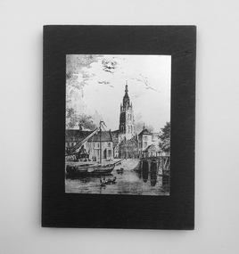
Etching
The Vliet is a canal in the western Netherlands, in the province of South Holland. It starts at the Oude Rijn at Leiden and joins the Delfshavense Schie canal at Delft. Places along its banks include Voorschoten, Leidschendam, Voorburg, The Hague and Rijswijk. The canal was dug in 47 AD under command of Roman general Corbulo, who wished to connect the river Rhine, of which the current Oude Rijn stream in Roman times was the main branch, to the Meuse estuary. It is unclear what the canal's trajectory was beyond the current city of Delft; the Delfshavense Schie canal, which connects Delft to the Nieuwe Maas river was not dug until 1389. In the Middle Ages the Vliet was an important trade link that attracted all kinds of trade, as it flowed through the heart of the County of Holland. Windmills have been constructed alongside the Vliet, including the completely renovated mill 'De salamander' in Leidschendam. The Vliet area was particularly attractive among richer families, who built their mansions along its banks.An historic small town scene etched (or possibly printed) on thin metal and subsequently fastened to a plywood backing. The delicately presented scene is said to show the intersection of Old Church Street and the Vliet Canal bridge in Voorburg, as well as a section of wharf. On the canal are one large and two much smaller vessels. A very tall crane-like construction arises from the wharf to the roof of waterside buildings. The people are soberly dressed in possibly 17th or 18th century costumes.On the reverse has been written: "Oude Kerkstraat Brug over de Vliet Voorburg". (Old Church Street; Bridge over the Vliet canal; Voorburg). However, research proves that the church is actually the Old Church in Delft, a short distance further down the Vliet Canal. -
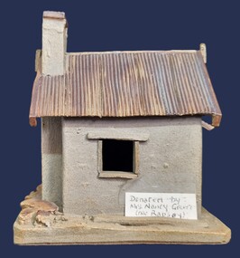 Wodonga & District Historical Society Inc
Artwork, other - Pollard's Creamery, Bonegilla Flats
George Pollard was born in Corfe, Dorsetshire England in 1824. Being dissatisfied as a clay miner, he decided to migrate to Australia. He migrated in 1851 and after a short unsuccessful time on the goldfields in Bendigo, followed by a period in Dederang and farming in Oxley, he selected land on Little River, now know as the Kiewa River in 1868. His property was know as Rosebank and George continued to live there until his death in 1915. In the early 1880s, George Pollard constructed a creamery on his property at Bonegilla Flat. The creamery stood until the late 1970s although in a state of ruin and used neaas a scratching post by the cattle which grazed in the surrounding paddock. The creamery included a chimney and fireplace. This generated warmth so that when large pans of milk were placed near the fire the cram would rise to the top and could easily be separated to produce butter for the growing family. In 1982 Fred Hillier was visiting from Queensland and offered to make the replica of the creamery featured Wodonga & District Historical Society Collection.This item is significant because it represents a creamery owned by an important family in the Bonegilla district.A small model of an old building made from clay. It includes a roof resembling corrugated iron and empty spaces for windows.Underneath Model Bonegilla Creamery 1886 By Fred Hillier 1982pollard family, agricultural buildings -
 University of Melbourne, Burnley Campus Archives
Album - CD black and white and sepia prints, Hilda Dance, 1935-1936
Hilda Dance (graduated 1936, staff 1941-47)2 copies of a CD with photographs taken by Hilda Dance. (1) 4 female students working in a flower bed. (2) 6 students at a flower show. (3) 4 female students on the lawn wearing dresses. (4) Group of students sitting on benches on the lawn. (5) 1936 Year Group. (6) 4 female students playing around on the lawn. (7) Students working near the Luffmann Ponds. (8) Newspaper cutting: 'She knows all the answers.' Student answering questions on a Vegetable Growing public day. (9) 2 female students playing around on the lawn. (10) Possibly an excursion to the zoo-man holding snake. (11) Female student bathing in the Yarra River. (12) Female student climbing a tree with steps cut into it, not Burnley. (13) Students bathing in the Yarra River. (14) 4 female students on the lawn wearing dresses. (15) Group of male students with lawnmower. (16) George Barnett/Russ? (17) Female student watering seedlings. (18) Group of male students with lawnmower. (19) Orchard Border. (20) Group of male students with lawnmower.hilda dance, female students, flower beds, students, flower show, luffmann ponds, students working outside, recreation, lawnmower, tree climbing, george barnett, orchard border, lily ponds -
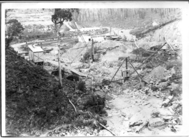 Kiewa Valley Historical Society
Photograph of Bogong Dam Wall Construction - 2 identical photos, c1940
Excavation of a diversion tunnel was commenced in 1939 to divert water from the East Kiewa River to allow construction of the dam wall. This was completed in February 1940 and excavation for the dam wall commenced in the same month, with the first batch of concrete placed in September. Lewis construction Company had the contract, but the S.E.C. took over construction in March 1942 and the dam was completed in March 1944. Type of construction: reinforced concrete, slab buttress.Importance in the Kiewa area as it shows the formwork and preparation necessary before the pouring of concrete for the first dam in the Kiewa Hydro Electric SchemeBlack and white photos (2 identical) of early construction of Junction Dam wall, viewed from downstream.Back of photo, upper right hand corner: No. 1 - Construction of Bogong Dam Wall (written in pencil) No. 2 - Same as one (written in pencil)construction, dam wall, excavation, bogong, secv -
 Warrnambool and District Historical Society Inc.
Document, Ticket Warrnambool Botanic Gardens Night in the Gardens, 2016
This card is an invitation to attend a Night in the Gardens in March 2016 to celebrate the 150th Anniversary of the Warrnambool Botanic Gardens. The first site of the Warrnambool Botanic Gardens was near the mouth of the Hopkins River but this site proved unsuitable and a new location ( the present location) was found in 1866 bounded by Cockman Street and Botanic Road. In 1877 William Guilfoyle was commissioned to provide a new plan for the Gardens. An important curator was Charles Scoborio ( 1872 to 1906 ) This card is of minor interest as a memento of the celebrations in 2016 to celebrate the 150th anniversary of the Warrnambool Botanic Gardens A black rectangular card with white text.Night in The Gardens warrnambool botanic gardens, charles scoborio