Showing 7098 items matching "snowy-river"
-
 Warrnambool and District Historical Society Inc.
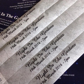
Document, Wristband Night in the Gardens, 2016
This wrist band was issued to those attending a Night in the Gardens, an event held in 2016 to celebrate the 150th Anniversary of the Warrnambool Botanic Gardens. These Gardens were first established near the mouth of the Hopkins River in the 1850s but this site proved unsuitable and they were moved to the present location ( Cockman Street/ Botanic Road) in 1866. In 1877 William Guilfoyle was commissioned to provide a plan of the Gardens. Charles Scoborio 1872 to 1906 was a prominent curator. A piece of paper with black printing and removable ends with adhesive on the back to form a temporary wrist band. Night in the Gardens 19th march 2016- 7 pm.william guilfoyle, charles scoborio -
 Port of Echuca
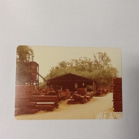
Colour photograph, 1979
Discussed in book : Echuca: A centenary history by Susan Priestley, pp.21, 38, 45, 66, 114-123, 126, 174 R.J.Evans established this mill on the banks of the Murray River, Echuca in 1923 & it operated until 1980. The mill later became a tourist attraction, Red Gum Works, continuing to cut timber until it was taken over by The Port of Echuca as a display (Port of Echuca booklet, 2005 ed., p. 32)Sawmilling was a very important industry for Echuca. At its peak in Echuca in about 1877 there were between 1000-1500 men employed in the industry (Priestley, Susan. 1965, p.118). Red gum was sourced from the forests along the Murray river. It is a very strong timber suitable for bridge & wharf building, construction works as well as housing and especially for sleepers for the railways. Mills relied on government contracts especially for the sleepers. Colour photograph (post-card size) of red gum sawmill on the Port of Echcua. Photograph is taken looking north.Printed on reverse: "this paper manufactured by Kodak."echuca, port of echuca, sawmilling, evans, r. j., red gum works -
 Greensborough Historical Society
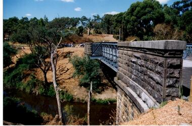
Photograph - Digital Image, Anne Paul, Opening of restored Old Lower Plenty Bridge 2001 - side view of bridge, 14/03/2001
The opening of the restored Old Lower Plenty Bridge, opened on 14/03/2001 by the Minister for Environment and Conservation Sherryl Garbutt MLA and Mayor of Banyule Cr Dale Peters. The project was jointly funded by Banyule Council and Parks Victoria. The restored bridge is the oldest remaining bridge in the former Shire of Eltham and forms part of the Plenty River Trail. This photograph shows the bridge from the side elevation, showing the bluestone and iron construction.Digital copy of colour photographlower plenty, lower plenty bridge, sherryl garbutt, dale peters, banyule council, parks victoria -
 Greensborough Historical Society
Map, Melbourne and Metropolitan Board of Works. Survey Division, MMBW, Yarra 2500 / 13.21. Central Greensborough, 1979_05
Melbourne and Metropolitan Board of Works. Yarra 2500 [base map]. 13-21, Parishes of Keelbundora 2856 and Nillumbik 3310, Municipality of Diamond Valley 257. Shows street names, easement sizes, lot numbers, lodged plan numbers, names of prominent features, contour values, creek or river names. Central Greensborough. Prominent streets: Main Street, Para Road, St Helena Road and Diamond Creek Road.MMBW Map in 1:2500 [scale] series. Cream parchment with green tape reinforcing on edges and punched holes on left edge.mmbw, melbourne and metropolitan board of works, shire of diamond valley, greensborough - maps -
 Greensborough Historical Society
Map, Melbourne and Metropolitan Board of Works. Survey Division, MMBW, Yarra 2500 / 12.19. Watsonia, Simpson Army Barracks, 1983_03
Melbourne and Metropolitan Board of Works. Yarra 2500 [base map]. 12-19, Parish of Keelbundora 2856, Municipalities of Diamond Valley 257 and 228. Shows street names, easement sizes, lot numbers, lodged plan numbers, names of prominent features, contour values, creek or river names. Watsonia Barracks (Simpson Army Barracks) and environs. Prominent streets: Yallambie Road, Greensborough Road, and Strathallan Road. MMBW Map in 1:2500 [scale] series. Cream parchment with green tape reinforcing on edges and punched holes on left edge.mmbw, melbourne and metropolitan board of works, shire of diamond valley, watsonia - maps -
 Greensborough Historical Society
Map, Melbourne and Metropolitan Board of Works. Survey Division, MMBW, Yarra 2500 / 13.22. Greensborough, Apollo Parkways, 1979_06
Melbourne and Metropolitan Board of Works. Yarra 2500 [base map] 13-22. Greensborough, Apollo Parkways. Parishes of Nillumbik 3310 and Keelbundora 2856. Municipalities of Diamond Valley 257 and Whittlesea 239. Prominent streets include: Plenty River Drive, Diamond Creek Road and Civic Drive. Includes Diamond Valley Civi Centre, Churinga, Janefield Colony Reserve and "proposed freeway" now Greensborough Highway (Bypass)MMBW Map in 1:2500 [scale] series. Cream parchment with green tape reinforcing on edges and punched holes on left edge.mmbw, melbourne and metropolitan board of works, shire of diamond valley, greensborough - maps, apollo parkways - maps -
 Greensborough Historical Society
Photograph - Digital image, Willis Vale, 1939c
Willis Vale: House built by Edward Maygar, Robert Whatmough lived there mid 19th century and later sold to Partington family. It was located on the Plenty River at Partington's Flat Greensborough. The derelict Willis Vale house was destroyed in 1964 when a fire originating from North Plenty Gorge - Kurrak Road - was lit by two teenage boys and made its way several kilometres down to Partington's Flat Greensborough.Home of the Partington family.Digital copy of black and white photograph.willis vale, partington family, maygar family, whatmough -
 Eltham District Historical Society Inc
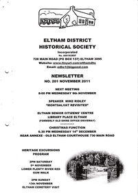
Newsletter, Newsletter, No. 201 November 2011
Contents: • Next meeting, guest speaker; Mike Ridley: Montsalvat Revisited • November Meeting • Lower Plenty River Red Gum Walk • Eltham Cemetery Visit • Christmas Function • 200 Newsletters – More to Come • A Brief History of the Bonds Road Area, Lower Plenty (From Newsletter No. 3, September 1978) • Grant from the Bendigo Bank • From Our Newspaper Files contributed by Harry Gilham • And Also The Shire of Eltham Historical Society was formed in October 1967. The first newsletter of the Society was issued May 1978 and has been published continuously ever since on a bi-monthly basis. With the cessation of the Shire of Eltham in late 1994, the Society's name was revised to Eltham District Historical Society and this name first appeared with issue No. 103, July 1995. The collection of the Society's newsletters provides a valuable resource on the history of the Society's activities, office bearers and committee members, guest speakers and subjects of historical interest pertinent to the former Shire of Eltham and the Eltham District.A4 photocopied newsletter distributed to membersnewsletter, eltham district historical society, shire of eltham historical society -
 Kiewa Valley Historical Society
Handmade Tool - Insect Cover or Sieve or Fishing Net or yabby trap
Flies are plentiful and a problem especially in Australia's summer. Farms were a breeding ground for flies that bred in cow manure. Fly-wire was used to keep flies away from food as well as light cloth covers. Farmers could use this sieve to fill with sand etc. to sort the sizes and also to use for eg. wheat to sort the grain. Yabbies are trapped in the creek or river by leaving food in the net for the yabby to crawl into.Food covers were used by residents of the Kiewa Valley especially as many of them were dairy farmers. Farmers often made their own tools for a purpose such as sieving or for the family catching yabbies to eat or for fun.Tall triangular steel fly wire cover with a steel handle and frame. or The frame can be held in order to fill the sieve or to empty it. or the frame can hold bait for yabbiesfood cover, fly-wire, flies, sieve, handmade tool -
 Orbost & District Historical Society
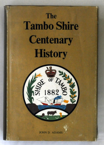
book, James Yeates & Sons, The Tambo Shire Centenary History, 1981
This is a local history of the Tambo Shire in East Gippsland. Tambo Shire (1882-1994) was created on 6 January 1882, by severance from Bairnsdale shire with Bruthen as the head . It was named after the Tambo River. Orbost Shire was originally a part of this shire as was Lakes Entrance. In 1994 Tambo shire was united with Bairnsdale city, Orbost and Omeo shires, most of Bairnsdale shire and part of Rosedale shire to form East Gippsland Shire.This book is a useful reference book on the history of the Tambo district.A 448 pp book with a gold coloured dust jacket with black print and an illustration of the Tambo Shire emblem 1882. It is titled " The Tambo Shire Centenary History".tambo-shire-history -
 Robin Boyd Foundation
Document - Script, Robin Boyd, The Flying Dogtor. Episode 14 The Cave, 1963
The Flying Dogtor, tricked by Crafty Carson Carpetbag into falling into an old mineshaft, wandered into an underground limestone cave and then slipped into a subterranean river. He was swept into a long dark tunnel. Meanwhile, high above him, Crafty tried to fly the Dogtor's plane away. He couldn't control it and the plane shot up into the sky without him, rolling over and over without a pilot, without its master, The Flying Dogtor.The Flying Dogtor" series was broadcast on Australian Television Network (later becoming the Seven Network) between February and April 1964 (see item D254 for schedule).Typewritten, carbon copy, foolscap, 2 pagesPages 1 & 2: handwritten corrections on both pagesthe flying dogtor, robin boyd, crawford productions, manuscript -
 Robin Boyd Foundation
Document - Script, Robin Boyd, The Flying Dogtor. Episode 15 Strange Spots, 1963
The Flying Dogtor fell into an underground river and was swept away by the current. At the same time his plane was set loose by Crafty Carson Carpetbag and was circling wildly without a pilot, high in the outback sky. Meanwhile, back at the Dogtor's base, the Hilltop Hospital, his poor nurse Sister Spaniel, was driven almost frantic trying to cope alone with a strange epidemic of spots that was sweeping the bush. She desperately needed The Flying Dogtor.The Flying Dogtor" series was broadcast on Australian Television Network (later becoming the Seven Network) between February and April 1964 (see item D254 for schedule).Typewritten, carbon copy, foolscap, 3 pagesthe flying dogtor, robin boyd, crawford productions, manuscript -
 City of Greater Bendigo - Civic Collection
Photograph - Portrait of Councillor Keck, W H Robinson, c 1913
The district of Strathfieldsaye was proclaimed in 1861 and named a Shire on the 17th September in 1866. It remained a shire until amalgamation in 1994 when it became part of the City of Greater Bendigo. The shire was located 8 km to the south- east of Bendigo and covered an area of 601 square kilometres and extended from the Calder Highway to the Coliban and Campaspe Rivers. The shire's administration centre was in Strathfieldsaye until 1972 when new offices were opened in Kennington.Framed black and white head and shoulder portrait of Councillor Keck with hand coloured and drawn detail. Profile slightly to right with walrus moustache. Cut oval brown mount decorated with text and flowers. Hand written title top and lower centre.Strathfieldsaye / Shire Council / W.H. Robinson / Photo / Bendigo / J.H.E Gribbs / Presented by / Cr Herbert Keck / President 1903-4. 1912-13.shire of strathfieldsaye, councillor keck, strathfieldsaye shire council, president of strathfieldsaye shire -
 City of Greater Bendigo - Civic Collection
Photograph - Councillor group portrait, W H Robinson, Strathfieldsaye Shire Council, 1909
The district of Strathfieldsaye was proclaimed in 1861 and named a Shire on the 17th September in 1866. It remained a shire until amalgamation in 1994 when it became part of the City of Greater Bendigo. The shire was located 8 km to the south- east of Bendigo and covered an area of 601 square kilometres and extended from the Calder Highway to the Coliban and Campaspe Rivers. The shire's administration centre was in Strathfieldsaye until 1972 when new offices were opened in Kennington.Photographic group portrait of eleven Strathfieldsaye Shire Councillors in front of the Strathfieldsaye Shire Hall. Five men are seated and six standing with one man standing further in back ground on the building's verandah. Photograph is attached directly to green mount card and framed. Gold lettering on mount.Strathfieldsaye Shire Councillors / R. B. Brennan (Sec.) W. J. Lowdes S. Doak M. Burns () N Condon B. Code (Inspector) / WH Robinson Photo Bendigo / T Somerville / W. I. Long / Fred Osborne (President) H Keck / W Dresler / With the President's (Cr. Fred Osborne) Compliments / September 23rd, 1909shire of strathfieldsaye, strathfieldsaye shire council, president of strathfieldsaye shire, strathfieldsaye shire hall -
 City of Greater Bendigo - Civic Collection
Photograph - Councillor group portrait, W H Robinson, Strathfieldsaye Shire Council
The district of Strathfieldsaye was proclaimed in 1861 and named a Shire on the 17th September in 1866. It remained a shire until amalgamation in 1994 when it became part of the City of Greater Bendigo. The shire was located 8 km to the south- east of Bendigo and covered an area of 601 square kilometres and extended from the Calder Highway to the Coliban and Campaspe Rivers. The shire's administration centre was in Strathfieldsaye until 1972 when new offices were opened in Kennington. Group portrait of 13 men / councilors, 5 seated and 8 standing dressed in suits. There are another 2 men further back in front of the hall doors. Photograph is taken outside the Strathfieldsaye Shire Hall.Srathfieldsaye Shire Council. / With the President's (Cr T. Somerville) Compliments. / September, 1910 / W.H. Robinson Photo. Bendigo Verso; William Drechslershire of strathfieldsaye, president of strathfieldsaye shire, strathfieldsaye shire council -
 City of Greater Bendigo - Civic Collection
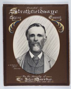
Photograph - Portrait of Councillor Burke
The district of Strathfieldsaye was proclaimed in 1861 and named a Shire on the 17th September in 1866. It remained a shire until amalgamation in 1994 when it became part of the City of Greater Bendigo. The shire was located 8 km to the south- east of Bendigo and covered an area of 601 square kilometres and extended from the Calder Highway to the Coliban and Campaspe Rivers. The shire's administration centre was in Strathfieldsaye until 1972 when new offices were opened in Kennington. Framed black and white head and shoulder portrait of Councillor Burke with hand coloured and drawn detail. Profile centre facing with beard. Cut oval brown mount decorated with text and fscrolls. Hand written title top and lower centre. Wooden frame with detail and gold inner.Presented to Strathfieldsaye / shire Council / w. H. robinson / Photo / Bendigo / By the family of / Cr John Burke / President 1890 - 1899 - 1900strathfieldsaye shire council, councillor burke, president of strathfieldsaye shire -
 City of Greater Bendigo - Civic Collection
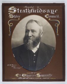
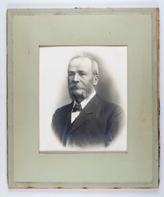
Photograph - Portrait of Councillor Thomas Somerville, W H Robinson
The district of Strathfieldsaye was proclaimed in 1861 and named a Shire on the 17th September in 1866. It remained a shire until amalgamation in 1994 when it became part of the City of Greater Bendigo. The shire was located 8 km to the south- east of Bendigo and covered an area of 601 square kilometres and extended from the Calder Highway to the Coliban and Campaspe Rivers. The shire's administration centre was in Strathfieldsaye until 1972 when new offices were opened in KenningtonFramed black and white head and shoulder portrait of Councillor Somerville with hand drawn detail. Profile slightly to left, face has full beard. Cut oval brown mount decorated with text and scrolls. Hand written title top and lower centre.Presented to / Strathfieldsaye / Shire Council / W. H. Robinson / Photo / Bendigo / by / Cr Thomas Somerville / President 1892 - 3. 1901.2. 1910.11 strathfieldsaye shire council, councillor somerville, president of strathfieldsaye shire -
 City of Greater Bendigo - Civic Collection
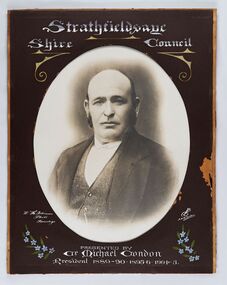
Photograph - Portrait of Councillor Michael Condon, W H Robinson
The district of Strathfieldsaye was proclaimed in 1861 and named a Shire on the 17th September in 1866. It remained a shire until amalgamation in 1994 when it became part of the City of Greater Bendigo. The shire was located 8 km to the south- east of Bendigo and covered an area of 601 square kilometres and extended from the Calder Highway to the Coliban and Campaspe Rivers. The shire's administration centre was in Strathfieldsaye until 1972 when new offices were opened in KenningtonFramed black and white head and shoulder portrait of Councillor Condon with hand coloured and drawn detail. Profile slightly to left. No facial hair. Cut oval brown mount decorated with text, scrolls and flowers. Hand written title top and lower centre.Strathfieldsaye / Shire / Council / W. H. Robinson / Photo / Bendigo / JMB Gribble / Presented by / Cr Michael Condon / President 1889 - 90. 1895-6. 1904 - 5strathfieldsaye shire council, president of strathfieldsaye shire, councillor condon -
 City of Greater Bendigo - Civic Collection
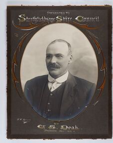
Photograph - Portrait of Councillor Doak, W H Robinson
The district of Strathfieldsaye was proclaimed in 1861 and named a Shire on the 17th September in 1866. It remained a shire until amalgamation in 1994 when it became part of the City of Greater Bendigo. The shire was located 8 km to the south- east of Bendigo and covered an area of 601 square kilometres and extended from the Calder Highway to the Coliban and Campaspe Rivers. The shire's administration centre was in Strathfieldsaye until 1972 when new offices were opened in Kennington.Framed black and white head and shoulder portrait of Councillor Doak with hand coloured and drawn detail. Left facing profile with walrus moustache. Cut oval brown mount decorated with text and scrolls. Hand written title top and lower centre.Presented to / Strathfieldsaye Shire Council / W. H. Robinson / Photo / JMB Gribble / by Cr S. Doak / President 1911 - 1912strathfieldsaye shire council, president of strathfieldsaye shire, councillor doak -
 City of Greater Bendigo - Civic Collection
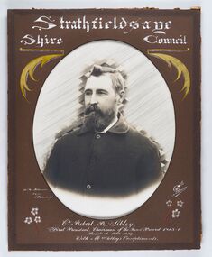
Photograph - Portrait of Councillor Sibley, W H Robinson
The district of Strathfieldsaye was proclaimed in 1861 and named a Shire on the 17th September in 1866. It remained a shire until amalgamation in 1994 when it became part of the City of Greater Bendigo. The shire was located 8 km to the south- east of Bendigo and covered an area of 601 square kilometres and extended from the Calder Highway to the Coliban and Campaspe Rivers. The shire's administration centre was in Strathfieldsaye until 1972 when new offices were opened in KenningtonFramed black and white head and shoulder portrait of Councillor Sibley with hand coloured and drawn detail. Profile slightly to left with walrus moustache and beard. Cut oval brown mount decorated with text, flowers and scrolls. Hand written title top and lower centre.Strathfieldsaye / Shire Council / W m Robinson / Photo / Bendigo / J N B Gribble / Cr Robert R Sibley / First President Chairman of the Road Board 1865 - 5 / President 1866 - 1869 / With Mrs Sibley's Complimentsstrathfieldsaye shire council, councillor sibley, president of strathfieldsaye shire -
 City of Greater Bendigo - Civic Collection
Photograph - Portrait of Councillor Long, Talma & Co
The district of Strathfieldsaye was proclaimed in 1861 and named a Shire on the 17th September in 1866. It remained a shire until amalgamation in 1994 when it became part of the City of Greater Bendigo. The shire was located 8 km to the south- east of Bendigo and covered an area of 601 square kilometres and extended from the Calder Highway to the Coliban and Campaspe Rivers. The shire's administration centre was in Strathfieldsaye until 1972 when new offices were opened in Kennington.Framed black and white head and shoulder portrait of Councillor Long. Profile to left with walrus moustache and mutton chops. Cut olive retangle mount. Verso; Long. On under board which has photograph attached; Talma & Co. / 119 Swanston St., / Melbournestrathfieldsaye shire council, councillor long -
 City of Greater Bendigo - Civic Collection
Photograph - Portrait of Councillor Hargraves, Bartlett Bros
The district of Strathfieldsaye was proclaimed in 1861 and named a Shire on the 17th September in 1866. It remained a shire until amalgamation in 1994 when it became part of the City of Greater Bendigo. The shire was located 8 km to the south- east of Bendigo and covered an area of 601 square kilometres and extended from the Calder Highway to the Coliban and Campaspe Rivers. The shire's administration centre was in Strathfieldsaye until 1972 when new offices were opened in KenningtonFramed black and white head and shoulder portrait of Councillor Hargraves. Profile slightly to right with walrus moustache. Cut rectangle brown mount decorated with coloured text and scrolls. Hand written title top and lower centre.Strathfiledsaye Shire Council / Cr John Hargreaves / President 1919 - 20 1928 - 29 / Presented by his Wife & Familystrathfieldsaye shire council, president of strathfieldsaye shire, councillor hargreaves -
 Wodonga & District Historical Society Inc
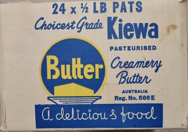
Functional object - Kiewa Dairy Box
The Kiewa Butter Factory began in 1893, named after the Kiewa River on which it is located. By 1905, butter shipped from Kiewa was receiving a top price of 114 s per cwt at the London market. It continued to prosper until 1959 when it merged with Tallangatta Butter Factory and Creamery Co. Ltd to become the North Eastern Dairy Company. In 1985 this organisation was taken over by the Murray Goulburn Co-operative.This package is representative of an important industry in Wodonga and the surrounding district.A packing box for butter from the Kiewa North Eastern Dairy. Made from heavy cardboard with blue and yellow design.On Front: 24 x 1/2 lb PATS / Choicest grade Kiewa/ Pasteurised / Creamery Butter/ AUSTRALIA / Reg. No. 566E/ BUTTER A delicious food On sides: 24 x 1/2 lb PATS / Choicest grade Kiewa/ Pasteurised / Creamery Butter/ AUSTRALIA / Reg. No. 566E/ North Eastern Dairy Co. Ltd. / KIewa Australianortheastern dairy co, dairies and butter factories, dairy industry victoria -
 Greensborough Historical Society
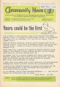
Newsletter, Greenhills and North Greensborough Progress Association, Community News: official journal of the Greenhills and Nth. Greensborough Progress Association and the Apollo Parkways Progress Association. 12th September, 1977. Edition No. 8/77, 12/09/1977
You could be the first [private swimming pool safety], Swimming pool safety debate, Market to market, In Diamond Valley, we commission our commissioner - Brian Waters, This and that, Children's Week, From the Council Chamber, Nillumbik Historical Society: history at Apollo Parkways - The Siphon Bridge on the Plenty River, Scout news, Diamond Valley Arts Society. A digital copy of this Newsletter is available from Greensborough Historical Society.Newsletter, 24 p., illus.greenhills and north greensborough progress association, greenhills, apollo parkways progress association, apollo parkways -
 Greensborough Historical Society
Newsletter, Greenhills and North Greensborough Progress Association, Community News: official journal of the Greenhills and North Greensborough Progress Association. 26th April, 1971. Edition No. 2/71, 26/04/1971
This edition includes a report on the Progress Association's April 1971 meeting, Councillors' report, Roads report "The Age", 3/4/71, Creative playground for school, Community isolation, Personal news, The Plenty River, Thoughts on an evening stroll. Rostrum Club planned for Greensborough, Supplement to "Community News". No. 2/71. Greenhills' panorama #2. p. 10-11. A digital copy of the Newsletter is available from Greensborough Historical Society.Newsletter, 18 p., illus. greenhills and north greensborough progress association, greenhills -
 Bendigo Historical Society Inc.
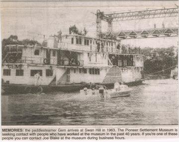
Newspaper - JENNY FOLEY COLLECTION: MEMORIES
The paddle steamer "Gem was first launched in 1876 as a passenger and cargo mode of transport on the Murray River. In the '30's and '40's it operated as a tourist passenger boat. In 1948 it sunk in 15 feet of water but was repaired and refloated. It was retired in 1950. In 1962 it was sold to the Swan Hill pioneer Settlement. The Swan Hill Folk Museum was Australia's first open air museum and opened to the public in 1966, It was renamed the Pioneer Settlement.Bendigo Advertiser ''The way we were'' from 2003. Memories: the paddle steamer Gem arrives at Swan Hill in 1963. the pioneer Settlement Museum is seeking contact with people who have worked at the museum in the past 40 years. The clip is in a folder.newspaper, bendigo advertiser, the way we were -
 Wangaratta RSL Sub Branch
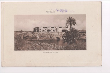
Postcard, 1917
From the album of WWI soldier William West (1268) of the 29 Infantry Battalion, 5th Pioneers Battalion. This collection of postcards, photographs and clippings were sent between William and his family and loved ones during the years he was on active service. Old Cataract Aswan Hotel is in the Nubian Desert on the banks of the Nile, opposite Elephantine Island.The majestic hotel sits on a pink granite cliff overlooking the world's longest river. Postcard depicting image of large rectangular building with lake and palm tree in foregroundAssouan Cataracte Hotelalbum, photo album, newspaper clippings, postcard, wwi, assouan, hotel -
 City of Greater Bendigo - Civic Collection
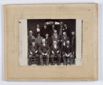
Photograph - Strathfieldsaye Councillor Group Portrait, D.G. Coope & Son - Framers
The district of Strathfieldsaye was proclaimed in 1861 and named a Shire on the 17th September in 1866. It remained a shire until amalgamation in 1994 when it became part of the City of Greater Bendigo. The shire was located 8 km to the south- east of Bendigo and covered an area of 601 square kilometres and extended from the Calder Highway to the Coliban and Campaspe Rivers. The shire's administration centre was in Strathfieldsaye until 1972 when new offices were opened in Kennington.Silver gelatin framed photographic group portrait of fifteen men taken in the alcove of the Strathfieldsaye Shire Hall. Four men are seated and eleven are standing. Photograph is attached directly to cream mount card. Handwritten note with photograph: 1/ John Burke, 2/ (?), 3/ (?), 4/ RHS Abbott, 5/ M Brennan, 6/(?) 7/(?) 1/. M Condon? 2/ (?) 3/ M Burns, 4/(?) Gentlemen at back are probably council staff.shire of strathfieldsaye, strathfieldsaye shire council, president of strathfieldsaye shire, councillor john burke, councillor r.h.s. abbott, councillor brennan, councillor condon, councillor m burns -
 Melbourne Tram Museum
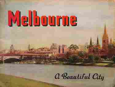
Book, Nucolorvue Publishing, "Melbourne - a Beautiful City", c1953
Published by Nucolorvue Productions of Mentone Melbourne, c1953 featuring colour photos of many locations in Melbourne, including an introduction. Has photos of Melburne landmarks, Collins St, Flinders St, Bourke St (with cable tram track), Flinders St Station, trams in streets, (W2 389, W5 777) St Kilda Road, the various parks, Royal Melbourne Hospital, St Kilda Beach, Yarra River, and Elizabeth St.Demonstrates a Nucolorvue production about Melbourne in the early 1950s.Book - 36 pages, colour printed, centre stapled. Printed on stippled paper.Has the stamp of "Queensland Book Depot, 61 Adelaide St Brisbane" on the inside front cover and pencil notes.mmtb, trams, tramways, souvenirs, melbourne, travel books -
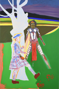 Latrobe Regional Gallery
Painting, COVENTRY, Christopher Lionel, Mackurnai, 1987
Explorer and settler Angus McMillan and Gunai Kurnai manSynthetic polymer paint on canvasOn reverse, on canvas c.l. "70 ARDEN STREET (JUDITH PUGH GALLERY) / MELBOURNE 1987 / MONASH UNIVERSITY / GIPPSLAND 1988 / - / AUSTRALIA GALLERY ('THE UPSIDE DOWN RIVER') / NEW YORK 1991" On stretcher c.r. green felt pen "COVENTRY" Titled on reverse on canvas u.r. cnr., pencil '"MAKURNAI" / A/g M 1987 / (arrow) (210 x 140) cm."' c.r., pencil "87"angus mcmillan, gunai kurnai