Showing 1355 items
matching a urban
-
 Kew Historical Society Inc
Flyer - 45 Pakington Street, Kew
Subdivision plans and real estate flyers/brochures reveal a number of aspects of urban development and history. The Kew Historical Society's collection of these plans, as well as advertisements extracted from magazines, cover key aspects of community development and architectural history of Kew and Kew Eat as well as surrounding suburbs. While most of the plans in the collection were gifted to the Society by the former City of Kew, a number of other plans and advertisements have been donated by individuals, of which this is an example.Single page illustrated real estate flyer advertising 45 Pakington Street, Kew for sale by auction. Annotation in pen and ink at rightpeter neville, real estate advertisements -- kew (vic.), 45 pakington street -- kew (vic.) -
Kew Historical Society Inc
Plan - Tramway Estate, Camberwell North, 1937
Subdivision plans and real estate flyers/brochures reveal a number of aspects of urban development and history. The Kew Historical Society's collection of these plans, as well as advertisements extracted from magazines, cover key aspects of community development and architectural history of Kew and Kew Eat as well as surrounding suburbs. While most of the plans in the collection were gifted to the Society by the former City of Kew, a number of other plans and advertisements have been donated by individuals, of which this is an example.Single page subdivision plan listing properties for sale in the Tramways Estate, Camberwell North. The large estate was bounded by Doncaster Road, Burke Road, Marwan Avenue, Maud Street, Severn Street, and extended over Glass's Creek at Mayland's Avenue. Within the plan, lots 3 to 342 are listed as lots. The plan includes annotations in ink indicating the prices realised by a number of lots. A key explains that lots with an 'H' represent a house, whereas the 37 shaded lots represent those being offered by this agent. subdivision plans -- camberwell (vic.), tramways estate -
Kew Historical Society Inc
Plan - Subdivisional Sale of 11 Villa Sites, East Kew, 1939
Subdivision plans and real estate flyers/brochures reveal a number of aspects of urban development and history. The Kew Historical Society's collection of these plans, as well as advertisements extracted from magazines, cover key aspects of community development and architectural history of Kew and Kew Eat as well as surrounding suburbs. While most of the plans in the collection were gifted to the Society by the former City of Kew, a number of other plans and advertisements have been donated by individuals, of which this is an example.Single page residential subdivision plan advertising house lots for sale, in what was then designated as East Kew but is now Kew, in the following streets: Burke Road, Enfield Street. The flyer includes a smaller locality plan at right. Information on the flyer indicates that the land was previously owned by the Melbourne & Metropolitan Tramways Board.subdivision plans -- kew (vic.), enfield street -- kew (vic.), burke road -- kew (vic.) -
Kew Historical Society Inc
Plan - Camberwell Panorama Estate, 1923
Subdivision plans and real estate flyers/brochures reveal a number of aspects of urban development and history. The Kew Historical Society's collection of these plans, as well as advertisements extracted from magazines, cover key aspects of community development and architectural history of Kew and Kew Eat as well as surrounding suburbs. While most of the plans in the collection were gifted to the Society by the former City of Kew, a number of other plans and advertisements have been donated by individuals, of which this is an example.Promotional brochure for the Camberwell Panorama Estate. The four page bifold handout advertises 216 home sites bounded by Bulleen Road, The Nook, Fortuna Avenue, and Doncaster Road. Other streets in the subdivision include: Sunburst Avenue, The Moor, and Macedon Avenue. The brochure has been damaged at some time in the past and so masking tape obscures the tram on page 1. Page 2 includes the plan of the subdivision, page 3 information about the site and a locality plan, while page 4 includes photographs and terms of sale. subdivision plans -- balwyn north (vic.), camberwell panorama estate -
Kew Historical Society Inc
Plan - Saxonwood Estate, Doncaster [East]
Subdivision plans and real estate flyers/brochures reveal a number of aspects of urban development and history. The Kew Historical Society's collection of these plans, as well as advertisements extracted from magazines, cover key aspects of community development and architectural history of Kew and Kew Eat as well as surrounding suburbs. While most of the plans in the collection were gifted to the Society by the former City of Kew, a number of other plans and advertisements have been donated by individuals, of which this is an example.Undated, multi-page subdivision plan advertising lots for sale bounded by Blackburn Road, George Street, Windermere Avenue, and Saxonwood Drive in what is currently Doncaster East. Other streets in the subdivision include: Mowbray Court, Stafford Court, Rugby Court, and Robin Hood Court. The front page includes a Birdseye view of the estate which identifies existing and projected civic amenities, as well as the estate's relationship to surrounding suburbs and the city centre. Red crosses on the detailed plan of lots on page two indicate those that have been sold. The final page includes a locality plan. saxonwood estate -- doncaster east (vic.), subdivision plans -- doncaster east (vic.) -
Kew Historical Society Inc
Plan - Charteris Estate, Ivanhoe [East], 1927
Subdivision plans and real estate flyers/brochures reveal a number of aspects of urban development and history. The Kew Historical Society's collection of these plans, as well as advertisements extracted from magazines, cover key aspects of community development and architectural history of Kew and Kew Eat as well as surrounding suburbs. While most of the plans in the collection were gifted to the Society by the former City of Kew, a number of other plans and advertisements have been donated by individuals, of which this is an example.Original 4-page bifold handout advertising 43 residential lots for sale in the Charteris Estate subdivision in Ivanhoe [now classified as Ivanhoe East]. This brochure was created to sell the third section of the estate which it labels as 'The Most Superb Section'. Streets within the subdivision include: Burke Road North, McArthur Road, Castella Street, and the Government Boulevard. In addition to the overall plan spread across pages 2 and 3, each page includes a number of interesting photographs including: a number of the new Burke Road Bridge, a sports ground, Hoyts Picture Theatre in Ivanhoe, a croquet ground, and Ivanhoe shopping centre [named Motor Cross Junction].charteris estate - east ivanhoe (vic), subdivision plans -- ivanhoe east (vic.), d.c. mcarthur, charterisville -
Kew Historical Society Inc
Plan - Pointed Firs Estate, Camberwell North, 1936
Subdivision plans and real estate flyers/brochures reveal a number of aspects of urban development and history. The Kew Historical Society's collection of these plans, as well as advertisements extracted from magazines, cover key aspects of community development and architectural history of Kew and Kew Eat as well as surrounding suburbs. While most of the plans in the collection were gifted to the Society by the former City of Kew, a number of other plans and advertisements have been donated by individuals, of which this is an example.Original multi-page sales brochure of the Pointed Firs Estate, advertised as located in Camberwell North, but now in Balwyn North. The 4-page bifold brochure includes promotional material as well as a detailed plan of the 28 lots for sale, a photograph of the locality with the plan overlaying it, as well as aerial photos and street views. The estate included lots in Doncaster Road, Thackeray Street, Houghton Street, an dMaud Street. pointed firs estate -- balwyn north, subdivisions -- balwyn north (vic.) -
Kew Historical Society Inc
Booklet - Old Kew Golf Links Estate, 1926
Subdivision plans and real estate flyers/brochures reveal a number of aspects of urban development and history. The Kew Historical Society's collection of these plans, as well as advertisements extracted from magazines, cover key aspects of community development and architectural history of Kew and Kew Eat as well as surrounding suburbs. While most of the plans in the collection were gifted to the Society by the former City of Kew, a number of other plans and advertisements have been donated by individuals, of which this is an example.8-page brochure advertising 80 residential home sites for sale in a subdivision called the 'Old Kew Golf Links Estate'. These sites had historic importance in Kew's history as they had previously belonged to Kodak Pty Ltd who were refused permission by Kew Council to use the land for industrial development. The estate, advertised was advertised as being within five miles of Melbourne. The brochure is notable as it includes photographs of Kew East Primary School, the former Kew Golf Club clubhouse, and 'The Moorings' Boathouse (aka Chipperfield's Boat House). The aerial photograph, overlaid with names of notable sites, on the final page is of interest as it shows the area before the intrusion of the Eastern Freeway, which resulted in changing the course of a section of the Yarra River. old kew golf links estate, subdivision -- kew (vic.), subdivisions -- kew east (vic), chipperfield's boathouse, kew east primary school, kew golf club -
Kew Historical Society Inc
Plan - Willsmere Park Estate, Kew, 1926
Subdivision plans and real estate flyers/brochures reveal a number of aspects of urban development and history. The Kew Historical Society's collection of these plans, as well as advertisements extracted from magazines, cover key aspects of community development and architectural history of Kew and Kew Eat as well as surrounding suburbs. While most of the plans in the collection were gifted to the Society by the former City of Kew, a number of other plans and advertisements have been donated by individuals, of which this is an example.Original 4-page, bifold subdivision plan of the Willsmere Park Estate, Kew. The 1926 land sale advertised '40 superb villa allotments' on the 'Yarra Heights'. Streets within the subdivision included: Willow Grove, Kilby Road, Elm Grove and Belford Road. The double page spread on pages 2 and 3 shows the detailed plan of the 40 lots, surrounded by public parkland [Willsmere Park] and the Kew Golf Links. By the time that this version of the plan was released, only the lots on Willow Grove and Kilby Road remained. willsmere park estate -- kew (vic.), subdivisions - kew (vic.), subdivisions -- kew east (vic.), willsmere park -- kew east (vic.) -
Kew Historical Society Inc
Booklet - Yarraleen Estate, Bulleen, c.1966
Subdivision plans and real estate flyers/brochures reveal a number of aspects of urban development and history. The Kew Historical Society's collection of these plans, as well as advertisements extracted from magazines, cover key aspects of community development and architectural history of Kew and Kew Eat as well as surrounding suburbs. While most of the plans in the collection were gifted to the Society by the former City of Kew, a number of other plans and advertisements have been donated by individuals, of which this is an example.Original 8-page booklet advertising a new residential development in Bulleen entitled 'Yarraleen'. The glossy multi-colour brochure includes historic and contemporary photographs of the Yarra Valley, graphic designs of potential residential development, photographs of key facilities (Marcellin College, Golf links, local swimming holes, the Beaver Swim School, Carey Grammar School Oval and grandstand, shopping strips, and farmland).subdivisions -- bulleen (vic.), yarraleen estate -
Kew Historical Society Inc
Plan - 30 Choice Home Sites in Kilby Road, Meldrum Street and Fairway Drive, 1965
Subdivision plans and real estate flyers/brochures reveal a number of aspects of urban development and history. The Kew Historical Society's collection of these plans, as well as advertisements extracted from magazines, cover key aspects of community development and architectural history of Kew and Kew Eat as well as surrounding suburbs. While most of the plans in the collection were gifted to the Society by the former City of Kew, a number of other plans and advertisements have been donated by individuals, of which this is an example.Original 4-page, bifold brochure, one of two in the collection, of home sites created following the creation of the Eastern Freeway which separated a section of land owned by the Kew Golf Club from the main course. The new estate featured 30 lots in Meldrum Street, Kilby Road and Fairway Drive. subdivisions -- kew east (vic.), subdivisions -- kew (vic.), kew golf club -
Kew Historical Society Inc
Plan - 30 Choice Home Sites in Kilby Road, Meldrum Street and Fairway Drive, 1965
Subdivision plans and real estate flyers/brochures reveal a number of aspects of urban development and history. The Kew Historical Society's collection of these plans, as well as advertisements extracted from magazines, cover key aspects of community development and architectural history of Kew and Kew Eat as well as surrounding suburbs. While most of the plans in the collection were gifted to the Society by the former City of Kew, a number of other plans and advertisements have been donated by individuals, of which this is an example.Original 4-page, bifold brochure, one of two in the collection, of home sites created following the creation of the Eastern Freeway which separated a section of land owned by the Kew Golf Club from the main course. The new estate featured 30 lots in Meldrum Street, Kilby Road and Fairway Drive.subdivisions -- kew east (vic.), subdivisions -- kew (vic.), kew golf club -
Kew Historical Society Inc
Plan - Burke Road Junction Estate, East Kew, 1940
Subdivision plans and real estate flyers/brochures reveal a number of aspects of urban development and history. The Kew Historical Society's collection of these plans, as well as advertisements extracted from magazines, cover key aspects of community development and architectural history of Kew and Kew Eat as well as surrounding suburbs. While most of the plans in the collection were gifted to the Society by the former City of Kew, a number of other plans and advertisements have been donated by individuals, of which this is an example.Original 4-page bifold brochure advertising the Burke Road Junction Estate in Kew East. Advertised for sale in 1940, the estate comprised 16 'Central Allotments' fronting High Street, Kilby Road, and Glass Street. Pages 1 & 4, the front and back covers, includes a panoramic photograph of the junction which features a number of shops still extant, but also with buildings long demolished and redeveloped. These include the petrol station and the dairy on the southeast and southwest corners of Burke Road and High Street/Doncaster Road. The dairy includes a statue of a cow on its roof. Pages 2 & 3 include a detailed plan of the estate. subdivisions -- kew east (vic.), burke road junction estate -
 Melbourne Tram Museum
Newspaper, The Age, "Melbourne rattles along in the top 10 of tram cities", 16/1/1995
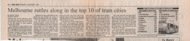
Newspaper cutting about the position of Melbourne trams in the world in terms of kilometres of track and the number of routes based on Jane's Urban Transport Systems. Has comments from the National Trust, PTUA, and about the tram fleet. Notes the recent growth in the Melbourne system. Item written by Bruce Tobin. How Jane's obtained or intepreted their information is unkinown - a check at the time of cataloguing notes that Prague was 144km and Poznan was about 66km of route - based on their Wikipedia pages. Yields information about Melbourne's position in the world tram list in 1995 - but this is subject to interepretion.Newspaper cutting from The Age 16/1/1995tramways, melbourne, length, routes -
 Broadmeadows Historical Society & Museum
Photograph, Meeting under the Pergola to Chat, Banksia Gardens, 1998, 3 February 1998
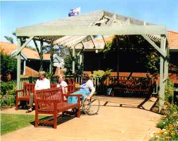
"Meeting Under the Pergola to Chat" is part of the Banksia Gardens collection from 1998. It captures a moment of social interaction within a public space designed for residents of social housing to meet and engage with their neighbours. This image highlights the significance of communal areas in fostering a sense of community and belonging among residents. The pergola serves as a focal point for social gatherings, reflecting the thoughtful urban planning aimed at enhancing social cohesion and quality of life in the housing development during that period.The photograph titled "Meeting Under the Pergola to Chat" is part of the Banksia Gardens collection from 1998. It depicts social housing with public spaces designed for neighbours to meet and interact. This image captures the essence of community life and the importance of shared spaces in fostering social connections within the housing development. The photograph not only documents the architectural and social planning of the era but also highlights the value placed on communal areas for enhancing the quality of life for residents.Colour photograph on glossy photographic paper."Pergola where neighbours meet to chat, Public Housing"/"Banksia Gardens 1998"social housing, banksia gardens, pergola, meeting place, 1998 -
![Women’s Day: Women’s Hospital 27th June 1919 [&] Queen Victoria Hospital](/media/collectors/550653872162f11fb04854aa/items/57a687e5d0cdd116a062e853/item-media/57a687fdd0cdd116a063064e/item-fit-380x285.jpg) Kew Historical Society Inc
Kew Historical Society IncBadge - Fundraising Button, Women’s Day: Women’s Hospital 27th June 1919 [&] Queen Victoria Hospital, 1919
Frances Rigg was a local business identity in Kew, at one stage managing the local branch of the English, Scottish and Australian (ES&A) Bank at 175 High Street from c. 1920 until the 1940s. After Francis Rigg’s death, the collection of buttons and medallions was inherited by his son, Ken Rigg (1922-2014). The collection was subsequently donated to the Kew Historical Society in 2015 by Francis' grandson, Adrian Rigg, at the time of the Gallipoli & Beyond Commemoration in 2015. The collection covers a period of almost 40 years. The majority of the buttons are patriotic buttons, issued and sold during and immediately after the First World World War (1914-1918) to raise funds for national and overseas causes. The collection also includes a number of locally significant sporting event buttons and sporting club medallions, issued in the 1920s and 1930s.Patriotic and other pressed tin buttons and badges were produced in large numbers in the first decades of the twentieth century. By nature, insubstantial and ephemeral, they have not always survived. The collections of badges, buttons and medallions in the Kew Historical Society collection is homogenous and yet diverse, ranging from buttons sold to raise funds for the war efforts in 1914-18 and 1939-45, to those used at festivals and sporting events. Because of the manufacturing process, many surviving buttons and badges have been affected by inadequate storage, suffering from oxidisation and physical damage. These survivors are now historically and socially significant artefacts, revealing much about the attitudes and values of the period in which they were produced. Their widespread distribution means that they are frequently significant at a local, state, national and international level.A pressed metal fundraising button released in 1919 to support the Royal Women’s and Queen Victoria Hospitals. In June 1919, The Argus reported that a ‘A well attended public meeting was held at the Town Hall yesterday afternoon to complete arrangements for the Button Day on June 27 in aid of the Women’s and the Queen Victoria Hospital. The Button Fund committee desires it to be known that several busy city sections are still vacant and that further offers of help in the sale of buttons will be welcomed’. It would appear that different buttons were released on the same day to support different hospitals in various urban and rural locations in Victoria."Women’s Day / Women’s Hospital 27th June 1919 [&] Queen Victoria Hospital"patriotic buttons, first world war (1914-18), royal womens hospital, queen victoria hospital, button fund -
 Eltham District Historical Society Inc
Document - Property Binder, Eltham Mall, 10-18 Arthur Street, Eltham
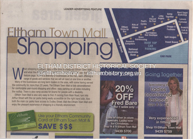
1. Eltham Town Mall Shopping, Diamond Valley Leader, October 26, 2005 [ On reverse - "Red alert for green area by Natalie Birch and Shane Woodrow about a report compiled by Environment Victoria, Melbourne's Threatened Habitats Under Threat: Development Pressures and Conservation Solutions which places the 'Nillumbik Foothills' number seven on list of most endangered by urban sprawl] 2. Advertisement: Huge Bikle Sale, Paul's Cycles, Diamond Valley Leader, February 7, 2007eltham, businesses, eltham town mall, paul's cycles, shops, brushtailed phascogale, click here to add keywords, cr greg johnson, eltham copper butterfly, environment victoria, environmental significance overlay, green wedges coalition, nillumbik shire council, powerful owl, significant landscape overlay, victorian national parks association, aroma's cafe and florist, arthur street, barringtons hair boutique, bowz hairdressing, eltham dress up box, going together, kids of eltham, leisure footwear, little angels, national australia bank, research computers, shoppe 8 fashions, split images, st vincent de paul, travel bound, ward sagar bookshop -
 Robin Boyd Foundation
Document - Manuscript, Robin Boyd, New Life For Our Cities, 1965
Boyd asks "What sort of cities do we want?" Various alternatives were discussed at the 14th Royal Institute of Architects convention 1965. The theme of the convention was Civic Development, accompanied by a public exhibition "Man in the Street". A fairly clear definition of the ideal shape for our urban character emerged. It was accepted that congestion, dullness and ugliness would become even more of a problem. Boyd offers a bird's eye view of the nature of our cities as we move progressively outwards.Original manuscript of an article published as ‘New life for Cities. The choice – metropolitan excitement or Canberra order?' in The Australian, 10.4.1965.Typewritten (c copy), quarto, 6 pagesroyal institute of architects convention 1965, australian cities, arthur odell, john overall, robin boyd, manuscript -
Ballarat Tramway Museum
Document - Report, State Electricity Commission of Victoria (SECV), "Creation of a state electricity Commission"
Report titled "Creation of a State Electricity Commission", and "History of Provincial tramways before Act No. 3845 - 1929". Outlines the context of the SEC Act of 1919 which did not include tramway operation by the power or electricity supply authority - was seen as a Municipal concern. Gives the alternatives that were considered, including the agreement with the Municipal Councils of Geelong, Ballarat, and Bendigo. Notes the operation of urban omnibus services and the issues of the lack of municipal supervision, though later on this occurred through the Transport Regulation Board.Yields information about the operation of the Provincial tramways under the control of the SECV.Five foolscap sheets, carbon copycouncils, secv, buses, ballarat, bendigo, geelong, trb -
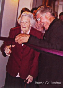 Melton City Libraries
Photograph, Edna Barrie, Unknown
Over 20 years commencing in the 1970s, Edna undertook extensive photographing of the changing streetscape of Melton’s High Street. She anticipated the impact of change on the community during the time of Melton’s rapid transition from a small farming district to a large urban community and this led to her extensively document and photograph many of the structures and landscape features of the township that have since been lost. She also meticulously recorded much of the contemporary life of the town and has left a significant legacy of archival material. Edna Barrie cutting a ribbon to an opening of a eventlocal identities, pioneer families -
 Kew Historical Society Inc
Map, MMBW, MMBW Plan No.117 Heidelberg & Kew, 1900-1910
The Melbourne and Metropolitan Board of Works (MMBW) was established by an act of the Victorian Parliament in 1890 to prepare for and to implement a sewerage and water reticulation system across what was then inner Melbourne, its surrounding and middle distance suburbs, including Kew. The MMBW was disbanded in 1991.The map collection of the Kew Historical Society has at its core the historic maps assembled and originally stored in the City Engineer's Department of the City of Kew. These include maps in a number of scales. The vast majority of maps were produced by the MMBW in the first two decades of the twentieth century, and are solid working maps, backed by linen for durability. These maps are historically significant to Kew, the City of Boroondara and to the history of the development of state utilities in Victoria. A number of the Kew maps have additional details added by former municipal officers, including the levels reached by various floods. As these were working documents, information was added to them long after the period of their initial production and distribution.Early map of part of the Borough of Kew, created in the early twentieth century, at a scale 160 ft to 1 inch. The map covers what was then the north eastern part of Kew showing the natural landscape and limited development on the south side of the Yarra River. In the Kew section, south of the river, the land is occupied currently by the Greenacres and Kew Golf Clubs. The map shows the extent of urban development by that time and the outlines of the few built structures in the municipality. The height above sea level of all parts of the landscape are indicated numerically in feet. Contour lines and the levels of historic floods were added in ink to the map at a later stage. MELBOURNE AND METROPOLITAN BOARD OF WORKS / PLAN NO. 117 / HEIDELBERG & KEW melbourne & metropolitan board of works, mmbw maps, borough of kew, cartography, mmbw plan no. 117, kew (vic.) -- maps, heidelberg (vic.) -- maps -
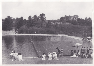 The Beechworth Burke Museum
Photograph, 1960s
Taken in the 1960s, depicted are approximately twenty-nine male and female spectators at a school swimming carnival on Lake Sambell near the caravan park. Lake Sambell is a beautiful Victorian recreation lake and urban park with a unique history. It was created in the mid-1800s by the Rocky Mountain Mining company during the gold rush era and used as a mining site until the early 1900s, which brought Europeans into the area. It was turned into a reserve for residents in 1920 and is considered an icon of Beechworth as it represents the development of the community, human endeavour, and the spirit of the landscape. This photograph represents the post-gold rush era use of Lake Sambell as a recreational reserve. Swimming carnivals were held at the lake and considered a social event for the Beechworth community.Black and white reproduced rectangular photograph print on paper.Reverse: Community/ Swimming pool 1960s/ near the caravan park/ Lakes?lake swimming pool, lake swimming, beechworth carnival processions, carnival, #beechworth, beechworth 1960s, victoria -
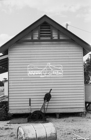
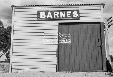
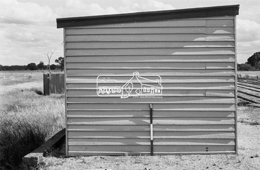
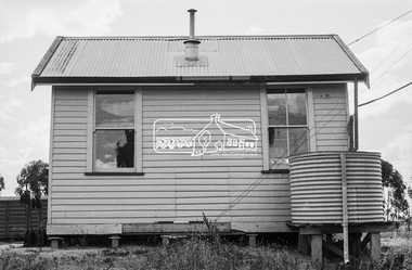
 Eltham District Historical Society Inc
Photograph, Barnes Railway Station, Moama, NSW, c.November 1962, 1962
The railway reached Echuca in 1864 and transformed the town into a major river port, with a famous wharf and substantial urban growth in the 1870s. In 1876 the Deniliquin and Moama Railway Company opened its 71 km (44 mi) private railway northwards to Barnes and Deniliquin, and the line at Echuca was extended across the Murray River into Moama to join the railway. This section was taken over by Victorian Railways in 1923, as part of the 1922 Border Railways Act. Barnes station was closed in 1979. Deniliquin railway line https://en.wikipedia.org/wiki/Deniliquin_railway_lineDigital TIFF file Scan of 35mm Ilford FP3 black and white negative transparencybarnes railway station, echuca, george coop collection, moama -
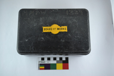 Melbourne Water
First Aid Kit (plastic lunch box), 1970s
As the Yarra became unsuitable as a source of water, several attempts were made to find alternative sources for the growing population of Melbourne. It was not until 1891 that the efforts to sewer Melbourne came to fruition with the setting up of the Melbourne Metropolitan Board of Works (MMBW), now known as Melbourne Water. From 1891 until 1992, it was the responsibility of the MMBW to safeguard public health by providing a sewerage system and a safe water supply system. In 1992, The MMBW merged with a number of smaller urban water authorities to form Melbourne Water.This first aid kit is of historical significance for its association with the former Melbourne and Metropolitan Board of Works (MMBW). The kit is relatively intact and a rare surviving object of standard Board issued equipment. The kit is significant for its representativeness of the theme of Safety that continues to resonate strongly within Melbourne Water today. First Aid Kit (plastic lunch box)MMBW 1339 (burnt into plastic) Board of Works Decalmelbourne metropolitan board of works, melbourne water, first aid kit, mmbw, safety, water, sewerage