Showing 16108 items
matching area
-
 Eltham District Historical Society Inc
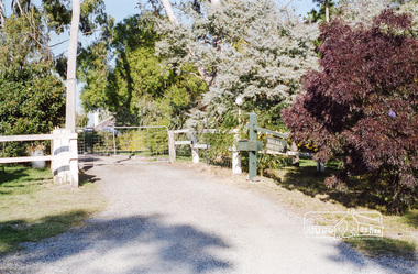
Photograph, Entrance to Rosehill, Bonds Road, Lower Plenty, Autumn Excursion to Lower Plenty area, 18 April 1998, 18/04/1998
Roll of 35mm colour negative film, 2 stripsKodak Gold 200-6activities, bonds road, lower plenty, rosehill -
 Eltham District Historical Society Inc
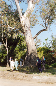
Photograph, Large River Red Gum, Stawell Road, Lower Plenty; Autumn Excursion to Lower Plenty area, 18 April 1998, 18/04/1998
Roll of 35mm colour negative film, 2 stripsKodak Gold 200-6activities, lower plenty, stawell road, trees, river red gum -
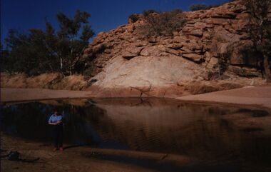
 Eltham District Historical Society Inc
Photograph, Amberley, Lower Plenty; Autumn Excursion to Lower Plenty area, 18 April 1998, 18/04/1998
Looking westerly across the Yarra from Westerfolds Park you can see a large and imposing building at the top of the escarpment above the river. This is the Christian Brothers Training Centre at Lower Plenty and known as Amberley. This significant building dates from 1930 when it was the rather grand residence of Oswald Darch. It was purchased by the Catholic Church in 1955 and has since been significantly extended.Roll of 35mm colour negative film, 2 stripsKodak Gold 200-6activities, lower plenty, amberley -
 Eltham District Historical Society Inc
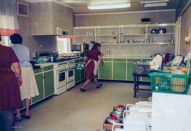
Photograph, Eltham Senior Citizens' Club Kitchen Area, c. Oct 1987, 1987
Home deliveries were also made up here. Used in Shire of Eltham display at the Eltham Community Festival, 7 November 1987.Colour photograph mounted on green-painted chipboard with string on back for hangingdisplay panel, eltham festival, infrastructure, shire of eltham, senior citizens' centre -
 Federation University Historical Collection
Newsclip, Ballarat Courier, Big Cats May Roam Area, 2012
Dr David Waldron has spent years trawling through government documents and speaking to old farmers and policemen trying to gather as much information as possible for a book on the subject of giant cats. In 2013 his book, co-authored with Simon Townsend, "Snarls from the tea-Tree: A History of Victorian Big cat Folkore" was published.Half a page from an undated Ballarat Courier with information relating to big cats in the Australian bush. It also includes an image of Dr David Waldron. The article is a response to the findings of Noel Judd of Smythesdale who reported the death of a Shetland pony , and found paw prints of a large cat nearby. Dy David Waldron considered plaster casts of the paw print and concluded they were almost certainly not made by a cat.australian animal folklore collections, big cats, smythesdale, waldron, judd -
 Federation University Historical Collection
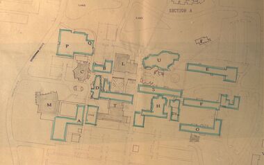
Plan - Site Plan, Mount Helen Campus Academic area
Federation University site plan made for the Ballarat College of Advanced Education Printed architectural plan of the Mount Helen campusprinted with location names and symbolssite plan, federation university, ballarat college of advanced education, mount helen campus, campus plan -
Federation University Historical Collection
Book, Land COnservation Victoria, Land Conservation Council Victoria Report of the North Eastern Area (district 1), 1972, 1972
Yellow and brown soft covered book with brown tapespine. Includes land use, recreation, agriculture, apiculture, vegetation, birds, water physiography, geology, climate, soils, fauna, land systems. Block descriptions include Bethanga, granya, Lawson, Walwa,Pine Mountain, Mittamatite, Elliot, Bunroy, Wabba, Mount Cadgewa, ucyvale, Koetan, Burrowa. Black and white images include Mitta Mitta arm, Corryong, Tallangatta, Lake Hume, Aboriginal rock shelter at Mount Porcupine, Koetong uplands, Mitta Mitta massif, bandicoot, wombat, skink, Flaggy Creek plateau, Walwa, Murray Cod, Thowgla, emu, grasstree, land conservation, north-eastern victoria, environment, landuse, recreation, timber, apiculture, water, upper murray, vegetation, birds -
Federation University Historical Collection
Book, John Slorach, From Timber to Tourism: Exploring Place Attachment and Natural Area Values in the Otway Ranges, 05/01/2007
Black hard covered book prepared for the BS801 Honours Research Dissertation, Bachelor of Business (Tourism) (Honours)university of ballarat, school of business, john slorach, mary hollick, tourism, timber, otway ranges, timber harvesting, forestry, environment -
Federation University Historical Collection
Book, From Timber to Tourism: Exploring Place Attachment and Natural Area Values in the Otway Ranges, 1997
Spiral bound reportuniversity of ballarat, school of business, tourism, apollo bay, otway national park, michelle brown, melinda gill, clare kearns, sarah mcewing, renee walder, cape otway lighthouse, point franklin residential estate, harbour, sand dune erosion, great ocean road, blanket bay, maits rest walking track -
Federation University Historical Collection
Report, Cultural Landscapes Study of Creswick Goldfields Area for Australian Hertiage Commission
White bound report with clear covergoldfields of victoria, goldfields tourism, marketing, tourism, creswick, creswick goldfields, allendale, broomfield, rocklyn, bullengarook, mollongghip, dean, scrub hill, clarkes hill, creswick railway station, creswick school of forestry, sawpit gully, oak gully, creswick cemetery, kingston, creswick avenue of honour, kerrins bridge, berry deep leads mine system, australasian mine site, creswick alluvial workings, calembeen park, ascot, anderson's mill, smeaton, hepburn lagoon -
 Federation University Historical Collection
Photograph - Colour, Chatham-Holmes Collection: Elizabeth and Philip Chatham, dry rocky area
chatham-holmes collection, elizabeth chatham, philip chatham -
Australian Commando Association - Victoria
Book, Australia in the War of 1939-45 ARMY South West Pacific Area
non-fiction -
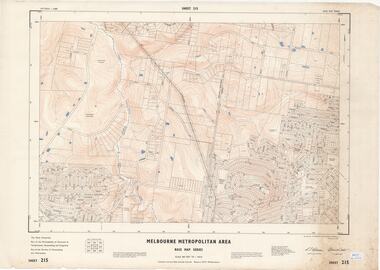 Ringwood and District Historical Society
Map - Melbourne Metropolitan Area Base Map Series, Sheet 215 - Ringwood area, 1967
Map prepared by Dept of Lands and Survey and MMBW from State Aerial Survey June 1957 and Cadastral Survey information July 1967. This sheet comprises parts of Municipalities of Doncaster & Templestowe, Nunawading and Ringwood, and Parishes of Nunawading and Warrandyte.Scale: 400 feet to 1 inch. Contours at 5 feet vertical interval. By Authority: A.C. Brooks, Commonwealth Printer, Melbourne. -
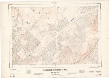 Ringwood and District Historical Society
Map - Melbourne Metropolitan Area Base Map Series, Sheet 216 - Ringwood area, 1967
Map prepared by Dept of Lands and Survey and MMBW from State Aerial Survey June 1957 and Cadastral Survey information July 1967. This sheet comprises parts of Municipalities of Croydon, Doncaster & Templestowe, and Ringwood, and Parishes of Ringwood and Warrandyte.Scale: 400 feet to 1 inch. Contours at 5 feet vertical interval. By Authority: A.C. Brooks, Commonwealth Printer, Melbourne. -
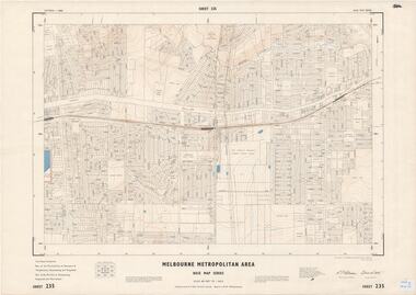 Ringwood and District Historical Society
Map - Melbourne Metropolitan Area Base Map Series, Sheet 235 - Ringwood area, 1960
Map prepared by Dept of Lands and Survey and MMBW from State Aerial Survey June 1957 and Cadastral Survey information August 1960. This sheet comprises parts of Municipalities of Doncaster & Templestowe, Nunawading and Ringwood, and Parishes of Nunawading, Ringwood and Warrandyte.Scale: 400 feet to 1 inch. Contours at 5 feet vertical interval. By Authority: A.C. Brooks, Commonwealth Printer, Melbourne. -
 Ringwood and District Historical Society
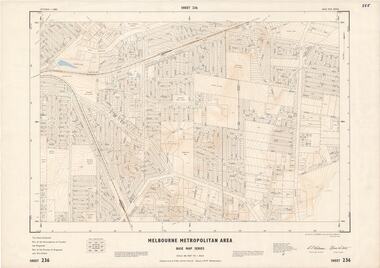
Map - Melbourne Metropolitan Area Base Map Series, Sheet 236 - Ringwood area, 1961
Map prepared by Dept of Lands and Survey and MMBW from State Aerial Survey June 1957 and Cadastral Survey information May 1961. This sheet comprises parts of the Municipalities of Croydon and Ringwood, and Parishes of Ringwood and Warrandyte.Scale: 400 feet to 1 inch. Contours at 5 feet vertical interval. By Authority: A.C. Brooks, Commonwealth Printer, Melbourne. -
 Ringwood and District Historical Society
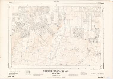
Map - Melbourne Metropolitan Area Base Map Series, Sheet 255 - Ringwood area, 1963
Map prepared by Dept of Lands and Survey and MMBW from State Aerial Survey December 1956 and Cadastral Survey information May 1963. This sheet comprises parts of the Municipalities of Ferntree Gully, Nunawading and Ringwood, and Parishes of Nunawading, Ringwood and Scoresby.Scale: 400 feet to 1 inch. Contours at 5 feet vertical interval. By Authority: A.C. Brooks, Commonwealth Printer, Melbourne. -
 Ringwood and District Historical Society
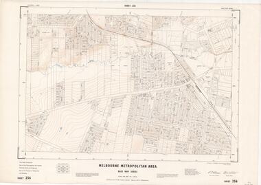
Map - Melbourne Metropolitan Area Base Map Series, Sheet 256 - Ringwood area, 1962
Map prepared by Dept of Lands and Survey and MMBW from State Aerial Survey December 1956 and Cadastral Survey information December 1962. This sheet comprises parts of the Municipalities of Croydon, Ferntree Gully, and Ringwood, and Parishes of Ringwood and Scoresby.Scale: 400 feet to 1 inch. Contours at 5 feet vertical interval. By Authority: A.C. Brooks, Commonwealth Printer, Melbourne. -
 Ringwood and District Historical Society
Map - State Aerial Survey, Dandenong Ranges Area, Parts of Parishes of Nunawading, Warrandyte and Ringwood - 1956
Map of Ringwood North and parts of Mitcham, Donvale, Park Orchards and Ringwood East compiled by Dept of Lands and Survey, July 1956, from aerial photographs and Cadastral Survey information. Sheet 1, Ringwood A2D or 849 A2D Zone 7. Scale: 4 chains to 1 inch. Contour interval 20 feet. -
 Ringwood and District Historical Society
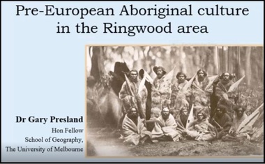
Mixed media - Video, RDHS Guest Speaker Presentation - "Local Pre-European Culture in the Ringwood Area" - Dr Gary Presland
Digitised video (6.64GB). Duration: 82 minutes. Recorded September, 2017 (Video is available for viewing at Ringwood & District Historical Society Archives by appointment)Presenter: Dr Gary Presland is a long-standing member of the Archaeological and Anthropological Society of Victoria, as well as a number of local historical societies, including Box Hill where he serves as President. -
 Ringwood and District Historical Society
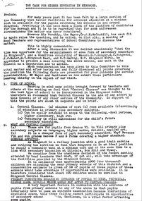
Document, Ringwood State School - Case for Higher Education in Ringwood area- 1938
Letter to Ringwood Council detailing the need for better facilities for advanced education in and around Ringwood. Signed by Messrs Dungey, Maher, Garing. Subsequent letter from Ringwood Council to Minister for Education. -
National Vietnam Veterans Museum (NVVM)
Booklet, Australian Army: Manual of land warfare, Part One: Vol.1, Pamphlet No.6: Administration in the area of operations (provisional), 1977
australia - armed forces - service manuals -
Port Melbourne Historical & Preservation Society
Negative - Negative, Barak Road Development Area Services plan, City of Port Melbourne, City of Port Melbourne, Barak Road Development Area Services, 27 Sep 1971
4" x 5" negative of City of Port Melbourne plan, Sept 1971, of services required for development between Barak and Beacon Roadstransport - railways, town planning, local government - city of port melbourne -
National Vietnam Veterans Museum (NVVM)
Journal, TAOR: tactical area of responsibility
veterans – australia – periodicals -
NMIT (Northern Melbourne Institute of TAFE)
Journal: Northern contact, Northern Area Consultative Committee 1998-2007
A4 size journal published since 1998. Years held 1998-2007 (incomplete). Dealt with 'Issues related to vocational skills, business growth and development, vocational education and training, school to work transition and demonstration and achievement of best practice in business, industry and education in the north of Melbourne.' northern area consultative committee, journals -
 Monbulk RSL Sub Branch
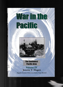
Book, Hawaii Pacific University, War in the Pacific Vol.4 :The South West Pacific Area, 2014
A broad history of the South West Pacific area war against JapanIndex, bib, ill, maps, p.288.non-fictionA broad history of the South West Pacific area war against Japanworld war 1939-1945 - history, world war 1939 – 1945 – campaigns – south west pacific -
Stanley Athenaeum & Public Room
Geological specimen - Galen on Quartz, Galen on Quartz (Gapsted area) - geological specimen
-
Moorabbin Air Museum
Manual (item) - Terminal Area Procedures - C'Wealth of Australia
-
Moorabbin Air Museum
Work on paper (item) - Bristol 170 (Freighter/Wayfarer), Untitled - sketch of Bristol 170 open nose cargo access area
Bristol Aeroplane Company Ltd -
Moorabbin Air Museum
Document (item) - C.A.C Area Distribution CA-31