Showing 1919 items
matching floods
-
 Greensborough Historical Society
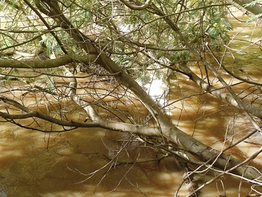
Photograph - Photograph - Digital Image, Marilyn Smith, Plenty River high water 2020, 24/08/2020
... floods ...Digital images high water in the Plenty River at Greensborough 24/08/2020. Part of a collection of miscellaneous historical images with a connection to the local area.7 Digital colour photographs of the Plenty River. plenty river, floods -
 Merbein District Historical Society
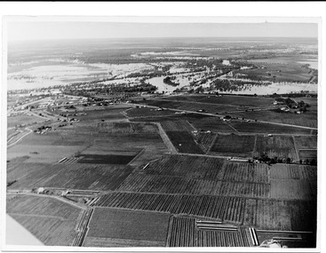
Photograph, Vineyards surrounding Merbein Pumps, unknown
... Floods ...blocks, floods -
 Merbein District Historical Society
Photograph, River Road 1956 flood, 1956
... Floods ...floods, murray river flood 1956 -
 Alexandra Timber Tramway & Museum
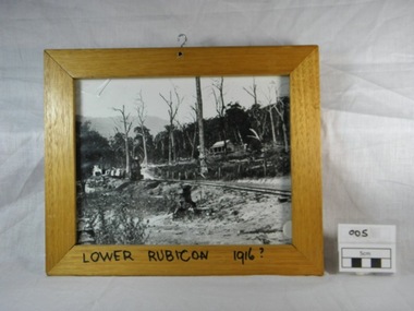
Framed black and white photograph, Untitled, Rails to Rubicon circa 1916, 1/1/1985 (estimated)
... floods ...We have not statement of significanceWooden framed black and white photograph of a two foot gauge steel rail line from the mill sight to Alexandra. This locomotive, a Kraus, steam engine (year ?)is passing through Lower Rubicon. It hauls three carriages with timber and on the side of the rail there are open boxes. A wooden house on Gilmore's family property is halfway up the hill. The property shows signs of damage of the recent Goulburn River flooding in 1916. There is a hook in the top of the frame and writing on the bottom of the frame "Lower Rubicon 1916".On bottom of the frame "Lower Rubicon 1916?" written with black texta colour pen in capital letters. 1916, cottage, rail, locomotive, train, floods, dead trees, two foot gauge, timber stacks, goulburn river floods, gilmore, lower rubicon, carriages, rubicon, kraus -
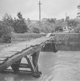
 Eltham District Historical Society Inc
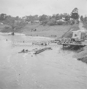
Album - Photograph, J.A. McDonald, Eltham-Greensborough Road, 18 Oct. 1956
... floods ...Bridge Street Bridge Flooding on Waterfall’s Estate 18th October 1956 Looking east up to Main Road over what is now present-day Alistair Knox Park Beware!.. our rivers are rising (1956, October 19). The Argus (Melbourne, Vic. : 1848 - 1957), p. 1. Retrieved August 24, 2022, from http://nla.gov.au/nla.news-article84392304Record of various Shire of Eltham infrastructure works undertaken during the period of 1952-1962 involving bridge and road reconstruction projects, sometimes with Eltham Shire Council Project Reference numbers quoted. It was during this period that a number of significant improvements were made to roads and new bridges constructed within the shire that remain in place as of present day (2022). In many situations, the photos provide a tangible visible record of infrastructure that existed throughout the early days of the Shire. The album was put together by or under the direction of the Shire Engineer, J.A. McDonald.infrastructure, road construction, shire of eltham, bridge construction, bridge street bridge, eltham, eltham-greensborough road, 1956-10-18, diamond creek (creek), floods, floodwater, silver street bridge, alistair knox park, waterfall property -
 Eltham District Historical Society Inc
Album - Photograph, J.A. McDonald, Eltham-Greensborough Road, 18 Oct. 1956
... floods ...Bridge Street Bridge Flood level on Greensborough pier 18th October 1956 View looking west across the Diamond Creek and tempoary walking access bridge towards intersection of Susan Street. The building visible on centreeline is the present-day SES facility. Beware!.. our rivers are rising (1956, October 19). The Argus (Melbourne, Vic. : 1848 - 1957), p. 1. Retrieved August 24, 2022, from http://nla.gov.au/nla.news-article84392304Record of various Shire of Eltham infrastructure works undertaken during the period of 1952-1962 involving bridge and road reconstruction projects, sometimes with Eltham Shire Council Project Reference numbers quoted. It was during this period that a number of significant improvements were made to roads and new bridges constructed within the shire that remain in place as of present day (2022). In many situations, the photos provide a tangible visible record of infrastructure that existed throughout the early days of the Shire. The album was put together by or under the direction of the Shire Engineer, J.A. McDonald.infrastructure, road construction, shire of eltham, bridge construction, bridge street bridge, eltham, eltham-greensborough road, 1956-10-18, diamond creek (creek), floods, floodwater, silver street bridge -
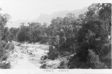 Halls Gap & Grampians Historical Society
Photograph - B/W
Photo shows Fyans Creek, looking South West towards the Pinnacle. View probably taken from the bridge. Fyans Creek appears to be very wide, perhaps after a flood.scenery, fyans creek -
Port Melbourne Historical & Preservation Society
Plan - Proposed bridge under Hobsons Bay railway at Clarendon Street, Emerald Hill, 1854 - 1884
Plan of proposed bridge under Hobson's Bay Railway at Clarendon Street, Emerald Hill, affecting Sandridge railway and Sandridge Road. Flood level re Sandridge line is shown.transport - railways, flood, emerald hill, town planning -
Clunes Museum
Photograph
3 X COLOUR PHOTOGRAPHS TAKEN AT MT CAMERON ROAD BRIDGE OF THE FLOODS OF AUGUST TO SEPTEMBER 2010 PHOTOGRAPHS WERE TAKEN ON 12/08/2010 AND 04/09/2010STICKER ON THE BACK OF PHOTOGRAPH: MC. EILEEN BRADSWORTH, CLUNESflood 2010, mt cameron road bridge -
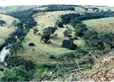 Hume City Civic Collection
Photograph
Lochton Flour Mill was established in the 1850s and is only one of a few surviving mills in Victoria. It is situated on a horseshoe bend on the Deep Creek at Bulla.A coloured photograph of a horse shoe bend in a river and the open flood plain. The river is tree-lined. The ruins of a stone building are on the river bend. A damaged fence and prickly pears are in the foreground.lochton mill, deep creek, hunter, william morrison, george evans collection -
University of Melbourne, Burnley Campus Archives
Plan, Royal Horticultural Society's Garden
Changed boundaries of the site burnley gardens, survey paddock, flood, lynch design, richmond park, yarra river -
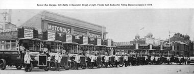 Melbourne Tram Museum
Photograph - Illustration, James Flood Charity Trust, c1914
Illustration from a photograph of 10 Tilling Stevens double deck buses operated by the Motorbus Services Limited. Have various destination of St Kilda Beach via Swanston St, St Kilda Rd Fitzroy St Esplanade. On the side of the bus is an advertisement for "Abbotsford Ale". From the James Flood Book as it notes that James Flood built 10 bodies during 1914 for the company. Photographed in Swanston St with the City Baths in the background.trams, tramways, melbourne, swanston st, buses, tilling stevens, private bus companies -
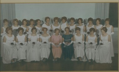 Bendigo Historical Society Inc.
Photograph - MAYORAL DEBUTANTE BALL, 1966-1967
Mayoral Debutante Ball 1960's, colour group photograph of Debutantes seated with Mayoress Mrs Tom Flood, under glass in a white timber frame with gold moulding. Deframed 2022Martin Washingtonphotograph, portrait, female group -
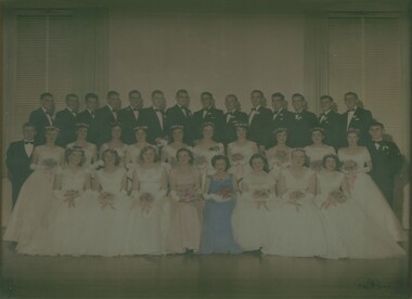 Bendigo Historical Society Inc.
Photograph - MAYORAL DEBUTANTE BALL, 1957-1958
Hand tinted photograph of Debutante Ball in 1950's showing group of Debutantes and partners with Mayoress Mrs Tom Flood, under glass with blond wood timber frame. Deframed 2022Reg Brockphotograph, portrait, group -
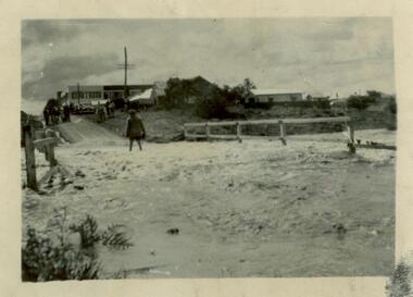
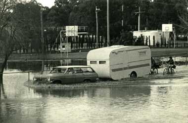 Charlton Golden Grains Museum Inc
Photograph - B/W Photograph of 1973 flood near Gordon Park, 1973 Flood, c. Feb 1973
1973 flood near Gordon Park, Car and caravan driving through flood water and road followed by two bicycles. Campers forced out of Gordon Park by rising flood waters c.1973Unframed B/W photograph flood, gordon park, charlton -
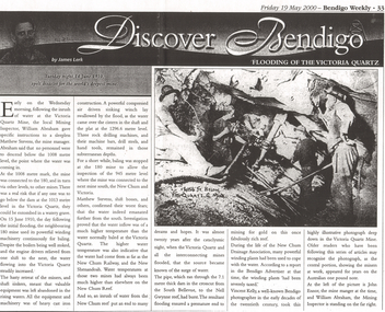 Bendigo Historical Society Inc.
Newspaper - LONG GULLY HISTORY GROUP COLLECTION: FLOODING OF THE VICTORIA QUARTZ
Copy of an article from the Bendigo Weekly 19/5/2000 Discover Bendigo - Flooding of the Victoria Quartz by James Lerk. Article mentions the flooding of the mine, the equipment left in there and where the water had come from. An accompanying photo, taken by Vincent Kelly, shows miners at work underground. John Ennor, the mine manager at the time and William Abraham, the Mining Inspector are in the photo. Written on the photo is: 4156 ft below Vic Quartz G Mine.bendigo, history, long gully history group, the long gully history group - flooding of the victoria quartz, bendigo weekly 19/5/2000, james lerk, william abraham, matthew stevens, 180 mine, new chum and victoria, new chum railway, new shenandoah, new chum reef, south bellevue, nell gwynne reef, new chum drainage association, bendigo advertiser, vincent kelly, john ennor -
Glenelg Shire Council Cultural Collection
Map - Map - Glenelg River, 1975
Laminated map, Glenelg River - Casterton, proposed flood level and lines to be designated. Photograph of map taken in 1975. Produced by Rural Water Commission to Shire Engineer, Casterton, attached to reverse of map.flood, flood levels, casterton -
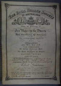 Victoria Police Museum
Certificate and Scroll (Robert Graham), 1888
Black embossed leather scroll with printed and handwritten Royal Humane Society Award Certificate awarded to Robert Graham for rescuing sufferers from the flood at the Goulburn River at Shepparton on 7th November 1887robert graham, greta, kelly gang, ellen kelly, royal humane society, bravery, awards, shepparton -
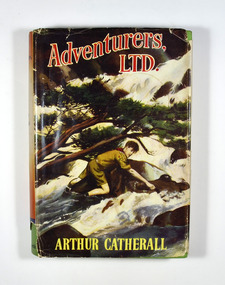 Marysville & District Historical Society
Book, Arthur Catherall, Adventurers, Ltd, 1954
Adventurers, Ltd., was a band of Scouts, all tip-top chaps. they liked to challenge Scouts in neighbouring towns-just to see how good they were. Not one of the Associations they visited ever succeeded in beating Andy, Sam Dodds, Smithy, Fatty Leadfield and the rest, but some of the adventures that came along in the process nearly did! Andy and the haunted tower, for instance; and Dickie Goole and the crashed pilot on the mountain; and the dangerous adventure of the two men in the quicksand. Another first-rate Scouting story by this favourite author.Dust cover has an illustration of a boy scout attempting to cross a flooded river. The reverse of the dust cover has information regarding The Crown Library; a series of school and adventure books for boys and girls.fictionAdventurers, Ltd., was a band of Scouts, all tip-top chaps. they liked to challenge Scouts in neighbouring towns-just to see how good they were. Not one of the Associations they visited ever succeeded in beating Andy, Sam Dodds, Smithy, Fatty Leadfield and the rest, but some of the adventures that came along in the process nearly did! Andy and the haunted tower, for instance; and Dickie Goole and the crashed pilot on the mountain; and the dangerous adventure of the two men in the quicksand. Another first-rate Scouting story by this favourite author.scouts, adventure, arthur catherall, fiction -
Tatura Irrigation & Wartime Camps Museum
Newspapers re/ local floods 1974, McPherson's Printing Group, Victoria, Tatura Guardian & Shepparton News, May 1974
Detailed history of 1974 floods in Shepparton and Mooroopna.Tatura Guardian 22 May 1974. Shepparton News 17th & 18th May 1974. Relating to record floods in the Goulburn River affecting Shepparton, Mooroopna, and Undera and to a lesser degree Tatura and Merrigum.record floods mooroopna & shepparton -
 Sunshine and District Historical Society Incorporated
Photograph (1954) - Flooded Bridge, 1954
1954 Photograph of KOROROIT CREEK in flood and overflowing the DERBY RD BRIDGE in Sunshine. Short time later this bridge was declared unsafe and closed to vehicle traffic. The Sunshine Technical School building is in the background.derby rd bridge, flood, kororoit creek, sunshine technical school, 1954 -
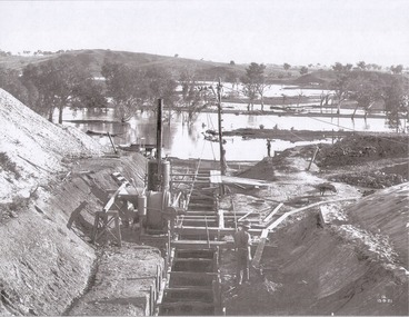 Wodonga & District Historical Society Inc
Album - Hume Reservoir Australia Album - Foundations for core wall of earth embankment, September 1921
This set of photos is from a leather bound album bearing the inscription "HUME RESERVOIR AUSTRALIA" plus 'The Rt. Hon. L. C. M. S. Amery, P. C., M .P.' all inscribed in gold. It was presented to The Rt. Hon. L. C. M. S. Amery, P. C., M. P, Secretary of State for Dominion Affairs on the occasion of his visit to the Hume Reservoir on 2nd November 1927. This album is of local and national significance as it documents the planning and development of the Hume Reservoir up to 1927. It was the largest water reservoir in the British Empire. The album records the pioneering engineering work that went into its construction.DEPARTMENT OF PUBLIC WORKS, N.S.W. RIVER MURRAY WATERS SCHEME. HUME RESERVOIR. 5. Foundations for core wall of earth embankment in New South Wales in September 1921. The River Murray in flood.hume reservoir australia, river murray waters scheme, hume weir diagrams, hume plan details -
 Lakes Entrance Historical Society
Photograph - Bridges, 1940
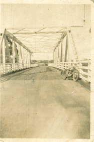
After 1934 flood damage to second bridge, centre pile was replaced by a truss girder, this survived until 1971 floodBlack and white photograph showing second Orbost Bridge over the Snowy River, wooden planks, railing and overhead support. Motor bike leaning on railing at near end of bridge. Orbost, Victoria.bridges, waterways -
 Eltham District Historical Society Inc
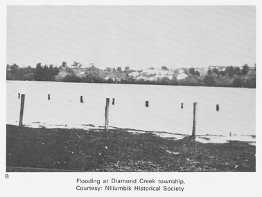
Work on paper (Sub-Item) - Photograph, Flooding at Diamond Creek Township
Black and white photograph of the Diamond Creek in flood at Diamond Creek township in 1934. In 1934 extensive flooding of the Yarra River and Diamond Creek set new records for flood plain level (Eltham Chronology EDHS) Nillumbik Historical Society collectionflood, diamond creek, flooding, nillumbik historical society -
 Eltham District Historical Society Inc
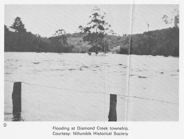
Work on paper (Sub-Item) - Photograph, Flooding at Diamond Creek Township
Black and white photograph of the Diamond Creek in flood at Diamond Creek township in 1934. In 1934 extensive flooding of the Yarra River and Diamond Creek set new records for flood plain level (Eltham Chronology EDHS) Nillumbik Historical Society collectionflood, diamond creek, flooding, nillumbik historical society -
 Bendigo Historical Society Inc.
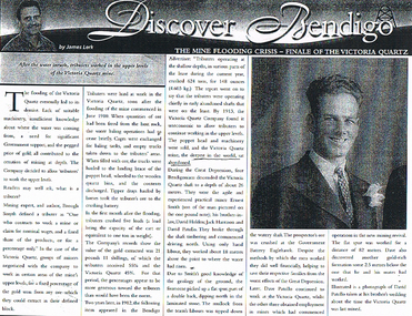
Document - LONG GULLY HISTORY GROUP COLLECTION: THE MINE FLOODING CRISIS - FINALE OF THE VICTORIA QUARTZ
BHS CollectionPhotocopy of a newspaper article titled Discover Bendigo by James Lerk titled The Mine Flooding Crisis - Finale of the Victoria Quartz. Soon after the flooding of the mine commenced in June 1910, tributers worked the upper levels. By 1913 the Company found it was uneconomic to allow tributers to continue working in the upper levels. Four Bendigo men, Ernest Smith, David Holden, Jack Harrison and David Patullo worked the mine during the Depression. They did well. A photo of David Patullo is in the article.bendigo, history, long gully history group, the long gully history group - the mine flooding crisis - finale of the victoria quartz, james lerk, victria quartz, brough smyth, bendigo advertiser 1912, great depression, ernest smith, david holden, jack harrison, david patullo, government battery eaglehawk -
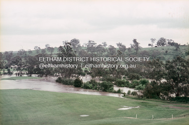 Eltham District Historical Society Inc
Slide, Floodwater, west from Clubhouse of Rosanna Golf Club, Lower Plenty, November 1971, 1971
Many parts of Melbourne flooded including Rosanna Golf Club, Lower Plenty in Novembere 1971. Many surburban roads, including the new south-eastern freeway were cut by flood waters. Here the level of the Plenty River floods onto the golf course. 35 mm colour positive transparency Mount - Agfacolor Service (Blue)floods, lower plenty, rosanna golf club, flooding, plenty river -
Glenelg Shire Council Cultural Collection
Photograph - Photograph reprint of scan of photograph - Flood August 1909, Casterton, Victoria, n.d
Vern McCallum CollectionReprint of scan of black and white photograph. Image show's Henty Street Casterton, flooded. Group of men on right standing in streets in ankle deep water. Print mounted on white archival mountboard frame. -
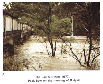 Eltham District Historical Society Inc
Work on paper (Sub-Item) - Photograph, Main Road Bridge, Eltham peak flow of flood 8 April, 1977
Colour photograph. Flooding of Diamond Creek at Main Road Bridge, Eltham peak flow of flood. Easter storm, 8 April, 1977flood, diamond creek, flooding, eltham, bridge, main road -
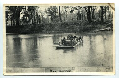 Orbost & District Historical Society
black and white photograph, late 19th century
A punt crossed the Snowy River at Orbost from 1884. A bridge was constructed in 1893, but was soon damaged by a huge flood. Flooding was a regular occurrence, the worst inundations being in 1870, 1893, 1925, 1934, 1952 and 1971. Over the years major flood protection works have been implemented. The Princes Highway, which passes Orbost, now crosses the flood plain on raised concrete supports. (info, from Victorian Places Orbost)This item is associated with the Snowy River and its history. It is a pictorial record of transport in the late 19th century.A black / white photograph (copy) of a punt loaded with people and a horse-drawn carriage making its way across a river.on front at bottom - "Snowy River Punt"snowy-river-orbost transport shipping