Showing 496 items matching " foreshore"
-
 Port Melbourne Historical & Preservation Society
Photograph - Port Melbourne beach area and Port Melbourne Town Hall, Alison Kelly, 1985
Fifty two (52) transparency slides of the Port Melbourne beach area and Port Melbourne Town Hallbeacons, natural environment - beaches and foreshore, built environment - civic, port melbourne town hall -
Port Melbourne Historical & Preservation Society
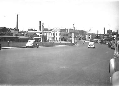
Photograph - Aerial view of Yarra River and surrounds, 1990s
COPYRIGHT THE AGE Aerial photograph showing the Yarra River, Webb Dock, Port Melbourne beach, Princes pier, West Gate Bridge, Maribyrnong River, Swanston Dock and Melbourne City skyline. Taken mid 1990sStamped "Copyright. This photograph may not be reproduced without permission in writing from the Photo sales department of "the Age"'built environment - commercial, engineering - bridges, fishermans bend, natural environment - beaches and foreshore, piers and wharves - princes pier, piers and wharves - webb dock, transport - shipping, yarra river, west gate bridge, sandridge beach, maribyrnong river, swanston dock -
Port Melbourne Historical & Preservation Society
Photograph - Port Melbourne Festival, Band Rotunda, Port Melbourne foreshore, David Thompson, 1995
Photo of Port Festival outside band rotunda Beach Stsocial activities, port melbourne festival, june wood, liana thompson, band rotunda -
Port Melbourne Historical & Preservation Society
Photograph - Panorama view of Port Melbourne foreshore, Commonwealth Engine Works to Williamstown, Alison Kelly, 1989
Colour panorama made up of 6 photographs from 1989. Photos taken by Alison Kelly from roof of Mission to Seamen building. Range of panorama extends from ruins of the Commonwealth Engine Works, Port Melbourne Railway Station, Centenary Bridge, Station Pier, Princes Pier, Beacon, to Williamstown. Ships include the Abel tasman and Linday Clark. The copy is a smaller black and white version in two pieces.centenary bridge, missions to seamen, piers and wharves - station pier, piers and wharves - princes pier, transport - shipping, beacons, transport - railways, alison kelly, abel tasman, linday clark -
Port Melbourne Historical & Preservation Society
Photograph - Port of Melbourne, launch of walkway from Sandridge Beach to Webb Dock, 2003
Port of Melbourne launch of the walkway from Sandridge Beach to Webb Dock late 2003. Colour photo. PMHPS members present Glen STUART, Jack BOLT, Maree CHALMERS, Janet BOLITHO, Perce WHITE.melbourne harbor trust - port of melbourne authority, natural environment - beaches and foreshore, piers and wharves - webb dock, janet bolitho, glen stuart, maree chalmers, perce mcguire white, perce white -
Port Melbourne Historical & Preservation Society
Document - Town of Port Melbourne, Sand Receipt Book, 1907
Town of Port Melbourne. Sand receipt book, recording moneys received by C W Hill for sand sold at Evans and Station street Reserves from July 8 to August 1, 1907local government - town of port melbourne, natural environment - beaches and foreshore -
Port Melbourne Historical & Preservation Society
Drawing - Illustration, Parliament of Victoria, "Shipping Cattle at Sandridge near Liardet's Hotel 1950"
In the 1980s it was in the State Patliament offices.Coloured print of a William Strutt watercolour of the Sandridge beach. Shows a cow being towed out by a rowboat to a ship, and other cows still on the beach. Print is framed in a 1980s simple wooden frame.natural environment - beaches and foreshore, transport - shipping, livestock, william strutt -
Port Melbourne Historical & Preservation Society
Photograph - Male public conveniences, Sinclair Parade, Beach Street, Port Melbourne, Alison Kelly, c. 1990
These are from the series taken by Alison Kelly c1990One from a set of two colour photos of the public conveniences in Sinclair Parade c1990: MEN/UOMINI/ANTRES.built environment - civic, natural environment - beaches and foreshore, transport - shipping, transport - ferries, alison kelly -
 Port Melbourne Historical & Preservation Society
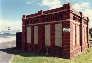
Photograph - Female public conveniences, Sinclair Parade, Beach Street, Port Melbourne, Alison Kelly, c. 1990
These are from the series taken by Alison Kelly c1990One from a set of two colour photos of the public conveniences in Sinclair Parade c1990: LADIES/DONNE/(GYNAIKA) The Abel Tasman is visible in the background'Toilet block, Beaconsfield Paradebuilt environment - civic, natural environment - beaches and foreshore, transport - shipping, transport - ferries, alison kelly -
Port Melbourne Historical & Preservation Society
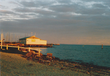
Photograph - Sandridge Beach looking towards Missions to Seamen building, Lyn Allison, 1992
From a series of photographs taken by Lyn Allison, when a councillor of the City of Port MelbournePhoto of concrete steps at Sandridge Beach looking south east towards Missions to Seamen buildingnatural environment - beaches and foreshore, missions to seamen, lyn allison -
Port Melbourne Historical & Preservation Society
Plan - Landscaping Westport Reserve, Port Melbourne, Graeme Bentley, Apr 1990
Plans for landscaping to complement Sandridge Life Saving ClubWorking drawings for landscaping Westport Reserve, Port Melbourne, 5pp, 1990'received 07 Jun 1991'natural environment - beaches and foreshore, westport reserve, bentley, graeme -
Port Melbourne Historical & Preservation Society
Document - 2014 Calendar, Pat Grainger, Historic Port Melbourne - Hotels, Sep 2013
Researched, written and designed by member Pat GRAINGER as a fundraiser for PMH&PS. 2014 PMHPS calendar ; Hotels. Cover shows Bay St from the North west showing Scott's Hotel and the National Bank of Australasia All following years calendars also recorded against cat no 1864built environment - commercial, business and traders - hotels, piers and wharves, sport - australian rules football, natural environment - beaches and foreshore, port melbourne historical & preservation society, pmhps, scott's hotel, lamb's hotel, chusan hotel, royal mail hotel, exchange hotel, united states hotel, t thomas, chequers inn, bay and boundary hotel, freemasons hotel, donaldson, peter gallienne grut, whithorn and son, foresters arms hotel, flower hotel, boundary rovers football club, wilbraham frederick evelyn liardet, pier hotel, london family hotel, prince alfred hotel -
Port Melbourne Historical & Preservation Society
Film - Video Recording - Digital, Tim Allen, What Lies Beneath Port Phillip Bay, 27 Apr 2021
Digital video recording of PMHPS meeting held on 27 April 2021. We all know Port Phillip Bay – or we think we do. It’s the beach on our back doorstep and our outdoor playground. But the Bay’s natural history, and its underwater values are largely unknown to most. And the Port Phillip Bay of today is very changed from the Bay at the time of white settlement. So, what of its future? Tim ALLEN's talk delves beneath the Bay’s surface veneer, to uncover stories of lost sharks and oyster beds, scallop wars, sewerage, and shipping; a visual potted history of key points in time.port phillip bay, natural environment - beaches and foreshore, tim allen -
Port Melbourne Historical & Preservation Society
Photograph - Electrical sub-station, Foreshore at Station Pier, Viva, 1989
Black and white photo taken 1989 by 'Viva', an artist from the Mission Arts Centre: electrical sub-station at foot of Station Pier, built 1940s?, which provided electricity to drive the travelling cranes on the pierbuilt environment - civic, piers and wharves - station pier, utilities - electricity -
 Port Melbourne Historical & Preservation Society
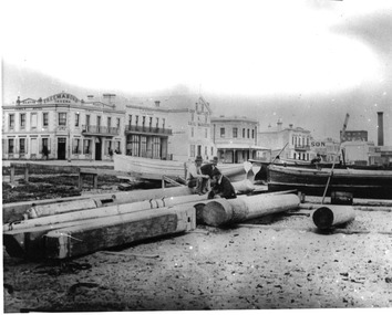
Photograph - Port Melbourne foreshore, Carolyn Goldberg, 1988
Ten coloured photographs taken in 1988 by Carolyn Goldberg (.01)&(.02) Photos of the Port Melbourne Yacht Club (pre fire). One is taken at distance. (.03)&(.04) Photos of Princes Pier locked up and abrred to public access (.05)&(.06) Photos of cranes on Station Pier. One taken at greater distance from Princes Pier (.07) The engine works building on future Beacon Cove site (.08)&(.09)Two views of the Centenary Bridge. One at greater distance. (.10)Photo of the area now known as Beacon Cove with City in distant backgroundpiers and wharves - station pier, piers and wharves - princes pier, societies clubs unions and other organisations, sport - yachting, built environment - civic, built environment - domestic, centenary bridge, carolyn goldberg, commonwealth engine works, port melbourne yacht club, pmyc, cranes (stodart?), liardet's beach, beacon cove -
Port Melbourne Historical & Preservation Society
Map, City of Port Melbourne, Oct 1963
Gives a visual understanding of the Port Melbourne area in 1963A detailed map of the Port Melbourne area in October 1963. Details roads and laneways, undeground cables, light and power poles, sewer, bridges, piers reserve and park areas.local government, built environment, piers and wharves, natural environment - beaches and foreshore, parks and gardens, piers and wharves - princes pier, piers and wharves - station pier, engineering - roads streets lanes and footpaths, engineering - canals and drainage -
Port Melbourne Historical & Preservation Society
Photograph - Perce White Reserve, Port Melbourne, 1990s
Three photos, origin unknown, of Perce White Reserve. .01 - (landscape) .02 - (portrait) open view into bush .03 - (portrait) dark path into bushNumbers in green on back 22, 23, 20parks and gardens, environment, friends of port melbourne foreshore, perce white reserve, perce mcguire white, perce white -
 St Kilda Historical Society
Photograph
Adjacent to the St Kilda Sea BathsColour photographst kilda, esplanade, st kilda foreshore, catani gardens -
![Vehicle - HMAS Lonsdale [HMVS], Built in 1884](/media/collectors/4f729f7e97f83e03086018d1/items/4fd575aa2162ef0ecc023165/item-media/613b16c26b487cd5e2ab7cba/item-fit-380x285.jpg) Queenscliffe Maritime Museum
Queenscliffe Maritime MuseumVehicle - HMAS Lonsdale [HMVS], Built in 1884
Transported to Victoria as deck cargo aboard s.s. Port Darwin. This vessel was ordered by Government of Victoria and was only used in training exercises in Port Philip and had become outmoded by the time the Royal Australian Navy was formed in 1911.Buried by sand in the grounds of the Queenscliffe Maritime Museum. There is no known record of how the "Lonsdale" ended abandoned on the beach at Queenscliff. Originally the land where the QMM is situated was the foreshore at the back of the houses in Beach Street, Queenscliff. There were two Torpedo boats built in 1884, the Lonsdale and the Nepean.Site of the buried remains of the Torpedo Boat HMAS Lonsdale [HMVS]hmas lonsdale, hmvs lonsdale, victorian navy, port phillip, royal australian navy -
 Bayside Gallery - Bayside City Council Art & Heritage Collection
Map, Department of Lands and Survey, Land under the control of the City of Sandringham, 1962
The cadastral map showing land under the control of the City of Brighton in 1962.map, plan, foreshores, sndringham, hampton, beaumaris, cheltenham, department of lands and survey, cartographic material, moorabbin, black rock, street map, city of sandringham, board of lands and works -
 Bayside Gallery - Bayside City Council Art & Heritage Collection
Map, Department of Crown Lands and Survey, Melbourne and Suburbs, City of Sandringham, 1917-1926
map, plan, foreshores, sndringham, hampton, beaumaris, cheltenham, department of lands and survey, cartographic material, borough of sandringham, moorabbin, black rock, street map, city of sandringham -
Friends of Ballarat Botanical Gardens History Group
Work on paper - Report Book, Ballarat City Council, May, 1890, Ballarat Botanical Gardens and Lake Wendouree, 1890
This page (3) of the May Report Book, 1890, covers 9 topics of news and matters of concern relating to the Ballarat Botanical Gardens, the Lake and Victoria Park.This Report gives a clear idea of the condition, progress made and plans for the Gardens and the Lake in 1890 and therefore is historically significant.1 sheet of paper, printed closely in font 14, with a photocopy line of the page (3) down the lefthand side of the page. The last line of the page is partially cut off but readable. Written at the top of the page in blue biro, "May Rep. Book, 1890 and beneath Win Little" (?) "Pavilion" is asterisked in black biro halfway down the 2nd paragraph and "Memorial to late Cr. Claxton" is marked in green. john garner, doctor, john garner collection, friends of ballarat botanical gardens, ballarat city council., pavilion, lake wendouree, rush cutting, improvements to foreshore, pisciculture, park and arbor day, swans., new green house, 1890, ballarat city council report books, ballarat botanical gardens, gardens, ballarat -
Port Melbourne Historical & Preservation Society
Photograph - Large wooden framed colour panorama photograph of Port Melbourne waterfront, Alison Kelly
Framed photograph. Taken from Station Pier admin building approx 1990. Shows Engine Works; London Hotel; Swallow & Ariell; West Gate Bridgebuilt environment, commonwealth government engine works, london family hotel, swallow & ariell ltd, west gate bridge, engineering - bridges, natural environment - beaches and foreshore, piers and wharves -
 Port Melbourne Historical & Preservation Society
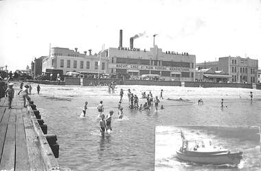
Photograph - Beach at foot of Princes Street, Port Melbourne, c1946 - 47
(From Glen Stuart). Photos taken from Centenary Bridge c1947. HMS Glory (inner East). HMS Implacable (outer East). HMS Indefatigable (outer West). Unknown freighter at Inner West. Ships still in wartime grey and used to transport personnel and equipment back to Australia after the war, before returning to England. PMHPS assume that these five photos (3354.01 - .05) were taken on the same day. See Glen Stuart's comment above although this photo has been taken from the Princes Street jetty beside Centenary Bridge looking back towards Beach Street. HMS Glory, Implacable and Indefatigable with attendant destroyers Tuscan and Armada arrived in Port Melbourne on 23 January 1946 and returned to England in 1947. [This series of photos 3354.01 - .05 as well as 3361 and 3362 came to PMHPS from the Moe Historical Society via the St Kilda Historical Society. Notations in pencil on the back along the left had edge indicate they came from "C W Ward photo, 355 High St, Prahran, Melbourne". Each photo bears the date 9-12-1947 in the top left corner. It is not known what this date refers to. Possibly it is when the photo was printed. Another notation on each photo says "Port Melbourne, taken in 1920". This is definitely incorrect and "NOT" has been written underneath this comment.]View from Princes Street jetty of London Family Hotel, Swallow and Ariell & children bathing. Small photo of Boat No 9 has been pasted at corner. C W Ward photo, 355 High St, Prahran, Melbournebeach street, natural environment - beaches and foreshore, built environment - commercial, london family hotel, swallow & ariell ltd, business and traders - hotels -
 Port Melbourne Historical & Preservation Society
Photograph - Black and white photo of Centenary Bridge, c1946-47
(From Glen STUART). Photos taken from Centenary Bridge c1947. HMS Glory (inner East). HMS Implacable (outer East). HMS Indefatigable (outer West). Unknown freighter at Inner West. Ships still in wartime grey and used to transport personnel and equipment back to Australia after the war, before returning to England. PMHPS assume that these five photos (3354.01 - .05) were taken on the same day. See Glen STUART's comment above. HMS Glory, Implacable and Indefatigable with attendant destroyers Tuscan and Armada arrived in Port Melbourne on 23 January 1946 and returned to England in 1947. [This series of photos 3354.01 - .05 as well as 3361 and 3362 came to PMHPS from the Moe Historical Society via the St Kilda Historical Society. Notations in pencil on the back along the left had edge indicate they came from "C W Ward photo, 355 High St, Prahran, Melbourne". Each photo bears the date 9-12-1947 in the top left corner. It is not known what this date refers to. Possibly it is when the photo was printed. Another notation on each photo says "Port Melbourne, taken in 1920". This is definitely incorrect and "NOT" has been written underneath this comment.]Black and white photo looking down Centenary Bridge towards the London Family Hotel and Swallow and Ariell. Also commercial businesses to left of bridge C W Ward photo, 355 High St, Prahran, Melbournenatural environment - beaches and foreshore, centenary bridge, built environment - commercial, london family hotel, swallow & ariell ltd, built environment - industrial, business and traders - hotels -
Port Melbourne Historical & Preservation Society
Photograph - CD-ROM, various Port Melbourne images, Charles Nettleton, 1875 - 1911
Gives us a visual description of Bay Street and other highlights in the late 1800s to early 1900sCD of digitised images from late 1800s to early 1900s. Images are of Bay St, from the North East; the Freemasons Hotel; Corner Beach and Stokes Streetsnatural environment - beaches and foreshore, built environment - commercial, bay street, beach street, stokes street, charles nettleton, carlton ale, fosters lager beer, whittle, business and traders - hotels, freemason's tavern -
Port Melbourne Historical & Preservation Society
Audio - PMHPS Meeting, Historical highlights of Port Phillip coast, Graham Patterson, Oral History
Graham Patterson talks about historical highlights of Port Phillip coast. PMHPS meeting 28/09/2015 Duration 0:55:21 (including meeting preliminaries)societies clubs unions and other organisations, natural environment - beaches and foreshore, graham patterson, port melbourne historical & preservation society, pmhps -
Port Melbourne Historical & Preservation Society
Photograph - Helen Thomas on the beach at Port Melbourne
B&W photo of Helen Thomas, aged about 10, on beach at foot of Johnston Street or Esplanade West, with gasometer in Graham Street in the background.sport, swimming, natural environment - beaches and foreshore, helen thomas -
 Port Melbourne Historical & Preservation Society
Photograph - Sandridge Beach, Charles NETTLETON, Charles Nettleton, Beach Street from the West, 1878
Damaged, mounted NETTLETON original:print of Sandridge Beach, buildings; three men and debris on the beach c1878natural environment - beaches and foreshore, built environment - commercial, charles nettleton, freemasons hotel, donaldson, business and traders - hotels -
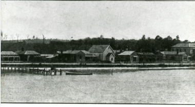 Lakes Entrance Historical Society
Photograph - Foreshore Lakes Entrance, 1910c
Black and white photograph of Esplanade, showing section of the western end of town. In picture are private homes, Methodist Church and Manse, Vizes Bellevue Guest House, Police Station and Kelvin House. Lakes Entrance Victoriapolice, houses, tourism, guesthouses