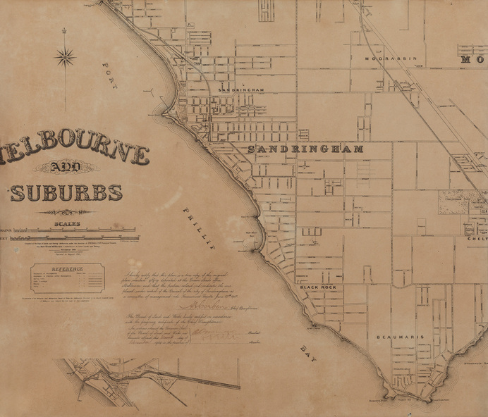
Map, Department of Crown Lands and Survey, Melbourne and Suburbs, City of Sandringham, 1917-1926
Melbourne and Suburbs, City of Sandringham
Reuse this media
Can you reuse this media without permission?No (with exceptions, see below)
Conditions of use
All rights reserved
This media item is licensed under "All rights reserved". You cannot share (i.e. copy, distribute, transmit) or rework (i.e. alter, transform, build upon) this item, or use it for commercial purposes without the permission of the copyright owner. However, an exception can be made if your intended use meets the "fair dealing" criteria. Uses that meet this criteria include research or study; criticism or review; parody or satire; reporting news; enabling a person with a disability to access material; or professional advice by a lawyer, patent attorney, or trademark attorney.
Attribution
Please acknowledge the item’s source, creator and title (where known)
Department of Lands and Survey, Melbourne, Melbourne and Suburbs, City of Sandringham 1917-1926, photolithograph, 45 x 52 cm. Bayside City Council Art and Heritage Collection
Photolithograph. Map in black ink on cream paper by the Department of Lands and Survey, Melbourne that indicates area placed under control of the Council of City of Sandringham, on 27 June 1917. Key indicates that the map shows Boundaries of Municipalities and Districts within the Municipalities; Railway lines; Cable, Electric and Horse Tramways. At lowest point of Map is Rickett's Point, top point shows Brighton Beach Pier. Suburbs include Sandringham, Black Rock, Beaumaris and parts of Cheltenham and Moorabbin. This was printed in 1926 and is a copy of the original plan from 1917.