Showing 654 items
matching kew- cotham road
-
 Kew Historical Society Inc
Plan - Subdivision Plan, Normanby Estate, East Kew, 1913
... with the real estate firm - J. R. Mathers and McMillan, 136 Cotham Road ...Pru Sanderson, in her groundbreaking ‘City of Kew Urban Conservation Study : Volume 2 - Development History’ (1988), summarised the periods of urban development and subdivisions of land in Kew. The periods that she identified included 1845-1880, 1880-1893, 1893-1921, 1921-1933, 1933-1943, and Post-War Development. These periods were selected as they represented periods of rapid growth or decline in urban development. An obvious starting point for Sanderson’s groupings involved population growth and the associated economic cycles. These cycles also highlighted urban expansion onto land that was predominantly rural, although in other cases it represented the decline and breakup of large estates. A number of the plans in the Kew Historical Society’s collection can also be found in other collections, such as those of the State Library of Victoria and the Boroondara Library Service. A number are however unique to the collection.The Kew Historical Society collection includes almost 100 subdivision plans pertaining to suburbs of the City of Melbourne. Most of these are of Kew, Kew East or Studley Park, although a smaller number are plans of Camberwell, Deepdene, Balwyn and Hawthorn. It is believed that the majority of the plans were gifted to the Society by persons connected with the real estate firm - J. R. Mathers and McMillan, 136 Cotham Road, Kew. The Plans in the collection are rarely in pristine form, being working plans on which the agent would write notes and record lots sold and the prices of these. The subdivision plans are historically significant examples of the growth of urban Melbourne from the beginning of the 20th Century up until the 1980s. A number of the plans are double-sided and often include a photograph on the reverse. The Normanby Estate, which was adjacent to Normanby Road, Kew East, included thirty-one lots for sale. Streets on the subdivision plan include Adeney Avenue, Park Hill Road, Normanby Road, Weir Street and Wharton Street. Cotham Road and its tramway are shown nearby. The plan is interesting as it shows Wharton Street, named after the architect and town planner George Wharton, who was the first chairman of the Municipality of Kew. The street was to later be renamed Cecil Street. Also shown are proposed ‘Municipal Gardens’ where Parkhill Drive is now located.subdivision plans - kew, normanby estate -
 Kew Historical Society Inc
Plan - Subdivision Plan, Violet Farm Estate, 1927
... with the real estate firm - J. R. Mathers and McMillan, 136 Cotham Road ...Pru Sanderson, in her groundbreaking ‘City of Kew Urban Conservation Study : Volume 2 - Development History’ (1988), summarised the periods of urban development and subdivisions of land in Kew. The periods that she identified included 1845-1880, 1880-1893, 1893-1921, 1921-1933, 1933-1943, and Post-War Development. These periods were selected as they represented periods of rapid growth or decline in urban development. An obvious starting point for Sanderson’s groupings involved population growth and the associated economic cycles. These cycles also highlighted urban expansion onto land that was predominantly rural, although in other cases it represented the decline and breakup of large estates. A number of the plans in the Kew Historical Society’s collection can also be found in other collections, such as those of the State Library of Victoria and the Boroondara Library Service. A number are however unique to the collection.The Kew Historical Society collection includes almost 100 subdivision plans pertaining to suburbs of the City of Melbourne. Most of these are of Kew, Kew East or Studley Park, although a smaller number are plans of Camberwell, Deepdene, Balwyn and Hawthorn. It is believed that the majority of the plans were gifted to the Society by persons connected with the real estate firm - J. R. Mathers and McMillan, 136 Cotham Road, Kew. The Plans in the collection are rarely in pristine form, being working plans on which the agent would write notes and record lots sold and the prices of these.The subdivision plans are historically significant examples of the growth of urban Melbourne from the beginning of the 20th Century up until the 1980s. A number of the plans are double-sided and often include a photograph on the reverse. A subdivision plan for nineteen ‘bonny, airy building blocks’ on either side of Violet Grove, Kew East. Violet Grove runs between High Street and Harp Road. Like many other subdivisions in Kew and East Kew, older houses (Lots 1 and 13) were often included in the subdivision. Such houses were in some instances the original properties that were subdivided, or in the case of the Violet Grove subdivision, new houses such as the weatherboard villa on lot 13. This villa is advertised as having a tiled roof, 5 rooms, panelled hall, double doors (Rooms 14 x 12 ft. 6 in. (2) 14 x 12, 12 x 11, 13 x 11). A bricked front verandah, a tiled stove recess and existing sewerage connection added to its saleable potential. Water, electric light and power, and gas were all offered as part of the deal. Violet Grove now has about 35 houses, which indicates that the 19 lots of the subdivision were to be further subdivided by purchasers. [A similar plan is in the Batten & Percy Collection of the State Library of Victoria.]subdivision plans - east kew, violet farm estate, violet grove -- kew (vic.), boorool road -- kew (vic.), harp road -- kew east (vic.) -
 Kew Historical Society Inc
Plan - Subdivision Plan, Flower Farm Estate, East Kew, 1922
... with the real estate firm - J. R. Mathers and McMillan, 136 Cotham Road ...Pru Sanderson, in her groundbreaking ‘City of Kew Urban Conservation Study : Volume 2 - Development History’ (1988), summarised the periods of urban development and subdivisions of land in Kew. The periods that she identified included 1845-1880, 1880-1893, 1893-1921, 1921-1933, 1933-1943, and Post-War Development. These periods were selected as they represented periods of rapid growth or decline in urban development. An obvious starting point for Sanderson’s groupings involved population growth and the associated economic cycles. These cycles also highlighted urban expansion onto land that was predominantly rural, although in other cases it represented the decline and breakup of large estates. A number of the plans in the Kew Historical Society’s collection can also be found in other collections, such as those of the State Library of Victoria and the Boroondara Library Service. A number are however unique to the collection.The Kew Historical Society collection includes almost 100 subdivision plans pertaining to suburbs of the City of Melbourne. Most of these are of Kew, Kew East or Studley Park, although a smaller number are plans of Camberwell, Deepdene, Balwyn and Hawthorn. It is believed that the majority of the plans were gifted to the Society by persons connected with the real estate firm - J. R. Mathers and McMillan, 136 Cotham Road, Kew. The Plans in the collection are rarely in pristine form, being working plans on which the agent would write notes and record lots sold and the prices of these. The subdivision plans are historically significant examples of the growth of urban Melbourne from the beginning of the 20th Century up until the 1980s. A number of the plans are double-sided and often include a photograph on the reverse. The subdivision called the ‘Flower Farm Estate’ in Kew East occurred in 1922. It included 61 lots on either side of Boorool Road between High Street and Harp Road. In an advertisement in The Argus in the same year, the proximity of the estate to the newly erected shops at the corner of Harp Road and High Street is noted. The Flower Farm Estate and similar subdivisions in Kew East were assisted by the extension of the High Street tramline in 1924.subdivision plans - east kew, flower farm estate, high street - kew east (vic.), boorool road -- kew east (vic.), harp road -- kew east (vic.) -
 Kew Historical Society Inc
Plan - Subdivision Plan, Palmyra Estate, 1918
... with the real estate firm - J. R. Mathers & McMillan, 136 Cotham Road ...Pru Sanderson, in her groundbreaking ‘City of Kew Urban Conservation Study : Volume 2 - Development History’ (1988), summarised the periods of urban development and subdivisions of land in Kew. The periods that she identified included 1845-1880, 1880-1893, 1893-1921, 1921-1933, 1933-1943, and Post-War Development. These periods were selected as they represented periods of rapid growth or decline in urban development. An obvious starting point for Sanderson’s groupings involved population growth and the associated economic cycles. These cycles also highlighted urban expansion onto land that was predominantly rural, although in other cases it represented the decline and breakup of large estates. A number of the plans in the Kew Historical Society’s collection can also be found in other collections, such as those of the State Library of Victoria and the Boroondara Library Service. A number are however unique to the collection.The Kew Historical Society collection includes almost 100 subdivision plans pertaining to suburbs of the City of Melbourne. Most of these are of Kew, Kew East or Studley Park, although a smaller number are plans of Camberwell, Deepdene, Balwyn and Hawthorn. It is believed that the majority of the plans were gifted to the Society by persons connected with the real estate firm - J. R. Mathers & McMillan, 136 Cotham Road, Kew. The Plans in the collection are rarely in pristine form, being working plans on which the agent would write notes and record lots sold and the prices of these. The subdivision plans are historically significant examples of the growth of urban Melbourne from the beginning of the 20th Century up until the 1980s. A number of the plans are double-sided and often include a photograph on the reverse. In 1918, Punch reported the sale of the Palmyra Estate. ‘Adjoining the Findon Estate at Kew is Palmyra, one of the most charming localities in this most desirable of all suburbs. Palmyra has frontages to Findon, Bakewell, Carson and Stevenson streets. Facing Carson street are eight blocks of 60 by 140; on Stevenson-street four of 60 by 232; and there are four of 60 by 233 on Bakewell-street.’ [Bakewell Street and Findon Street were later to be amalgamated into Findon Crescent.]subdivision plans - kew, studley park, palymyra estate, stevenson street -- kew (vic.), carson street -- kew (vic.), bakewell street (findon crescent) -- kew (vic.) -
 Kew Historical Society Inc
Plan - Subdivision Plan, Kewdene Estate, 1937-1939
... with the real estate firm - J. R. Mathers & McMillan, 136 Cotham Road ...Pru Sanderson, in her groundbreaking ‘City of Kew Urban Conservation Study : Volume 2 - Development History’ (1988), summarised the periods of urban development and subdivisions of land in Kew. The periods that she identified included 1845-1880, 1880-1893, 1893-1921, 1921-1933, 1933-1943, and Post-War Development. These periods were selected as they represented periods of rapid growth or decline in urban development. An obvious starting point for Sanderson’s groupings involved population growth and the associated economic cycles. These cycles also highlighted urban expansion onto land that was predominantly rural, although in other cases it represented the decline and breakup of large estates. A number of the plans in the Kew Historical Society’s collection can also be found in other collections, such as those of the State Library of Victoria and the Boroondara Library Service. A number are however unique to the collection.The Kew Historical Society collection includes almost 100 subdivision plans pertaining to suburbs of the City of Melbourne. Most of these are of Kew, Kew East or Studley Park, although a smaller number are plans of Camberwell, Deepdene, Balwyn and Hawthorn. It is believed that the majority of the plans were gifted to the Society by persons connected with the real estate firm - J. R. Mathers & McMillan, 136 Cotham Road, Kew. The Plans in the collection are rarely in pristine form, being working plans on which the agent would write notes and record lots sold and the prices of these. The subdivision plans are historically significant examples of the growth of urban Melbourne from the beginning of the 20th Century up until the 1980s. A number of the plans are double-sided and often include a photograph on the reverse. The advertisement for the ‘Kewdene Estate’ subdivision is pasted over a photograph of a property for sale. This is typical of the reuse of promotional materials in the period during, and subsequent to World War I. The subdivision included 14 lots bordered by Belmore Road, Birtles Street and Giles Street. On the other side of the subdivision [Glass] Creek is noted. The subdivision plan also shows part of the Outer Circle Railway and Deepdene Railway Station.subdivision plans - east kew, kewdene estate, belmore road -- kew east (vic.), giles street -- kew east (vic.) -
 Kew Historical Society Inc
Plan - Subdivision Plan, Boulevard Estate - Boulevard Section, 1930-1936
... with the real estate firm - J. R. Mathers and McMillan, 136 Cotham Road ...Pru Sanderson, in her groundbreaking ‘City of Kew Urban Conservation Study : Volume 2 - Development History’ (1988), summarised the periods of urban development and subdivisions of land in Kew. The periods that she identified included 1845-1880, 1880-1893, 1893-1921, 1921-1933, 1933-1943, and Post-War Development. These periods were selected as they represented periods of rapid growth or decline in urban development. An obvious starting point for Sanderson’s groupings involved population growth and the associated economic cycles. These cycles also highlighted urban expansion onto land that was predominantly rural, although in other cases it represented the decline and breakup of large estates. A number of the plans in the Kew Historical Society’s collection can also be found in other collections, such as those of the State Library of Victoria and the Boroondara Library Service. A number are however unique to the collection.The Kew Historical Society collection includes almost 100 subdivision plans pertaining to suburbs of the City of Melbourne. Most of these are of Kew, Kew East or Studley Park, although a smaller number are plans of Camberwell, Deepdene, Balwyn and Hawthorn. It is believed that the majority of the plans were gifted to the Society by persons connected with the real estate firm - J. R. Mathers and McMillan, 136 Cotham Road, Kew. The Plans in the collection are rarely in pristine form, being working plans on which the agent would write notes and record lots sold and the prices of these. The subdivision plans are historically significant examples of the growth of urban Melbourne from the beginning of the 20th Century up until the 1980s. A number of the plans are double-sided and often include a photograph on the reverse. This plan shows a subdivision with two sections: the ‘Boulevard Section’ and the ‘Riverside Section’. The first of these sections bordered Burke Road between Kilby Road and the farm beside the Yarra. Kilby Road, Munro Road, Burke Road and Old Burke Road bordered the 102 lots in the Boulevard Section of the plan. The streets within the Section included Walbundry Avenue, Inverness Way, Riverside Avenue, Cascade Street and Kyora Parade. These street names, at least in this subdivision plan linked the two Sections of the subdivision. At a later date, the City of Kew decided to alter the street names. Walbundry, Inverness, Riverside, Cascade and Kyora were all renamed as ‘Drives’ (e.g. Kyora Drive). The subdivision plan is of interest in that it names High Street in Kew as Doncaster Road. It also shows the location of the wooden church that was later removed to Yarraville on the corner of Kilby Road and High Street. The plan predates later developments such as the S. E. Dickens Supermarket.subdivision plans - east kew, boulevard estate, munro road -- kew east (vic.), kilby road -- kew east (vic.), burke road -- kew east (vic.), walbundry avenue -- kew east (vic.), inverness way -- kew east (vic.), riverside avenue -- kew east (vic.), cascade drive -- kew east (vic.), nyora parade -- kew east (vic.) -
 Kew Historical Society Inc
Plan - Subdivision Plan, Goldthorns Hill Estate, 1925
... with the real estate firm - J. R. Mathers and McMillan, 136 Cotham Road ...Pru Sanderson, in her groundbreaking ‘City of Kew Urban Conservation Study : Volume 2 - Development History’ (1988), summarised the periods of urban development and subdivisions of land in Kew. The periods that she identified included 1845-1880, 1880-1893, 1893-1921, 1921-1933, 1933-1943, and Post-War Development. These periods were selected as they represented periods of rapid growth or decline in urban development. An obvious starting point for Sanderson’s groupings involved population growth and the associated economic cycles. These cycles also highlighted urban expansion onto land that was predominantly rural, although in other cases it represented the decline and breakup of large estates. A number of the plans in the Kew Historical Society’s collection can also be found in other collections, such as those of the State Library of Victoria and the Boroondara Library Service. A number are however unique to the collection.The Kew Historical Society collection includes almost 100 subdivision plans pertaining to suburbs of the City of Melbourne. Most of these are of Kew, Kew East or Studley Park, although a smaller number are plans of Camberwell, Deepdene, Balwyn and Hawthorn. It is believed that the majority of the plans were gifted to the Society by persons connected with the real estate firm - J. R. Mathers and McMillan, 136 Cotham Road, Kew. The Plans in the collection are rarely in pristine form, being working plans on which the agent would write notes and record lots sold and the prices of these. The subdivision plans are historically significant examples of the growth of urban Melbourne from the beginning of the 20th Century up until the 1980s. A number of the plans are double-sided and often include a photograph on the reverse. The Goldthorns Hill Estate subdivision was first put up for auction in 1925. The subdivision took its name from the mansion ‘Goldthorns’, shown on the plan between Normanby Road and Lady Loch’s Drive. Contemporary advertisements describe forty-three home sites being fro sale, yet only forty-one appear on this plan. Buyers were lured by the prospect of the proposed extension of the Burke Road tram to High Street. Discerning buyers were advised that only one house could be built per allotment, and that houses needed to be constructed of brick, stone or concrete and have a slate or tiled roof.goldthorns avenue -- kew east (vic.), lady loch drive -- kew east (vic.), argyle road -- kew east (vic.), lady brassey drive -- kew east (vic.), campbell street -- kew east (vic.), goldthorns -- kew (vic.), subdivisions -- kew east (viv.), goldthorns hill estate -
 Kew Historical Society Inc
Map - Subdivision Plan, Grenville Estate, 1922
... in Cotham Road and Alfred Street, Kew, the auctioneers emphasised... of the Grenville Estate in Cotham Road and Alfred Street, Kew ...Pru Sanderson, in her groundbreaking ‘City of Kew Urban Conservation Study : Volume 2 - Development History’ (1988), summarised the periods of urban development and subdivisions of land in Kew. The periods that she identified included 1845-1880, 1880-1893, 1893-1921, 1921-1933, 1933-1943, and Post-War Development. These periods were selected as they represented periods of rapid growth or decline in urban development. An obvious starting point for Sanderson’s groupings involved population growth and the associated economic cycles. These cycles also highlighted urban expansion onto land that was predominantly rural, although in other cases it represented the decline and breakup of large estates. A number of the plans in the Kew Historical Society’s collection can also be found in other collections, such as those of the State Library of Victoria and the Boroondara Library Service. A number are however unique to the collection.Subdivision plans are historically important documents used as evidence of the growth of suburbs in Australia. They frequently provide information about when the land was sold on which a built structure was subsequently constructed as well as evidence relating to surveyors and real estate and financial agents. The numerous subdivision plans in the Kew Historical Society's collection represent working documents, ranging from the initial sketches made in planning a subdivision to printed plans on which auctioneers or agents listed the prices for which individual lots were sold. In a number of cases, the reverse of a subdivision plan in the collection includes a photograph of a house that was also for sale by the agent. These photographs provide significant heritage information relating house design and decoration, fencing and household gardens.In advertising the twenty-two sites of the Grenville Estate in Cotham Road and Alfred Street, Kew, the auctioneers emphasised the proximity of the development to shops, schools, and churches. That mansions surrounded the Estate was publicised as an added attraction. The plan shows how at this stage A regrettable aspect of this plan is that it is pasted over, and obscures a real estate photograph by the Kew photographer Josiah Earl Barnes.subdivision plans - kew, grenville estate, glenferrie road, alfred street, thomas street, cotham road -
 Kew Historical Society Inc
Plan - Subdivision Plan, St Helliers Estate, Kew, circa 1910, c.1910
Pru Sanderson, in her groundbreaking ‘City of Kew Urban Conservation Study : Volume 2 - Development History’ (1988), summarised the periods of urban development and subdivisions of land in Kew. The periods that she identified included 1845-1880, 1880-1893, 1893-1921, 1921-1933, 1933-1943, and Post-War Development. These periods were selected as they represented periods of rapid growth or decline in urban development. An obvious starting point for Sanderson’s groupings involved population growth and the associated economic cycles. These cycles also highlighted urban expansion onto land that was predominantly rural, although in other cases it represented the decline and breakup of large estates. A number of the plans in the Kew Historical Society’s collection can also be found in other collections, such as those of the State Library of Victoria and the Boroondara Library Service. A number are however unique to the collection.Subdivision plans are historically important documents used as evidence of the growth of suburbs in Australia. They frequently provide information about when the land was sold on which a built structure was subsequently constructed as well as evidence relating to surveyors and real estate and financial agents. The numerous subdivision plans in the Kew Historical Society's collection represent working documents, ranging from the initial sketches made in planning a subdivision to printed plans on which auctioneers or agents listed the prices for which individual lots were sold. In a number of cases, the reverse of a subdivision plan in the collection includes a photograph of a house that was also for sale by the agent. These photographs provide significant heritage information relating house design and decoration, fencing and household gardens.In the subdivision of part of Crown Portion 82, bordered by John and Sackville Streets and Cotham and Burke Roads, over 100 lots were offered for sale. In addition to the designated lots, a number of key locations are also identified. These include the Genazzano Convent to the north of Cotham Road, the Reservoir, St Hilary’s and the land holding of Colonel Parnell on the corner of John Street and Cotham Road. On the Plan, No. 5064, is the handwritten name ‘St. Hellier’s Estate’. St. Helliers, the home of the Dumaresq family is shown beside St. Hilary’s.subdivision plans - kew, st helliers estate -
 Kew Historical Society Inc
Plan - Subdivision Plan, Erin Heights Estate, East kew, 1917
... with the real estate firm - J. R. Mathers and McMillan, 136 Cotham Road ...Pru Sanderson, in her groundbreaking ‘City of Kew Urban Conservation Study : Volume 2 - Development History’ (1988), summarised the periods of urban development and subdivisions of land in Kew. The periods that she identified included 1845-1880, 1880-1893, 1893-1921, 1921-1933, 1933-1943, and Post-War Development. These periods were selected as they represented periods of rapid growth or decline in urban development. An obvious starting point for Sanderson’s groupings involved population growth and the associated economic cycles. These cycles also highlighted urban expansion onto land that was predominantly rural, although in other cases it represented the decline and breakup of large estates. A number of the plans in the Kew Historical Society’s collection can also be found in other collections, such as those of the State Library of Victoria and the Boroondara Library Service. A number are however unique to the collection.The Kew Historical Society collection includes almost 100 subdivision plans pertaining to suburbs of the City of Melbourne. Most of these are of Kew, Kew East or Studley Park, although a smaller number are plans of Camberwell, Deepdene, Balwyn and Hawthorn. It is believed that the majority of the plans were gifted to the Society by persons connected with the real estate firm - J. R. Mathers and McMillan, 136 Cotham Road, Kew. The Plans in the collection are rarely in pristine form, being working plans on which the agent would write notes and record lots sold and the prices of these. The subdivision plans are historically significant examples of the growth of urban Melbourne from the beginning of the 20th Century up until the 1980s. A number of the plans are double-sided and often include a photograph on the reverse. A number of the latter are by noted photographers such as J.E. Barnes.The Erin Heights Estate in Kew included just seven lots in in Valerie Street. These were all that remained of this wartime subdivision, the other 11 allotments on Balfour and Belford Roads having already been sold. Balfour Road was to be only a temporary name as the street is currently called Windella Avenue. Now, the parkland opposite the subdivision is the reserve created from the route of the Outer Circle Railway. This Railway reached Kew East in 1925, but had been planned as far back as 1873. The development focuses on the benefits of living in Kew: being at the highest of Kew’s ‘suburbs’; being a good residential area; its rapid growth; and the proximity of the Kew East tram in High Street. In 1917, the electric tramline only extended to a terminus at the Harp of Erin hotel. The terminus is clearly represented on the plan.subdivision plans - east kew, erin heights estate -
 Kew Historical Society Inc
Plan - Subdivision Plan, J R Mathers & McMillan, Willsmere Park Estate, c.1940
... with the real estate firm - J. R. Mathers and McMillan, 136 Cotham Road ...Pru Sanderson, in her groundbreaking ‘City of Kew Urban Conservation Study : Volume 2 - Development History’ (1988), summarised the periods of urban development and subdivisions of land in Kew. The periods that she identified included 1845-1880, 1880-1893, 1893-1921, 1921-1933, 1933-1943, and Post-War Development. These periods were selected as they represented periods of rapid growth or decline in urban development. An obvious starting point for Sanderson’s groupings involved population growth and the associated economic cycles. These cycles also highlighted urban expansion onto land that was predominantly rural, although in other cases it represented the decline and breakup of large estates. A number of the plans in the Kew Historical Society’s collection can also be found in other collections, such as those of the State Library of Victoria and the Boroondara Library Service. A number are however unique to the collection.The Kew Historical Society collection includes almost 100 subdivision plans pertaining to suburbs of the City of Melbourne. Most of these are of Kew, Kew East or Studley Park, although a smaller number are plans of Camberwell, Deepdene, Balwyn and Hawthorn. It is believed that the majority of the plans were gifted to the Society by persons connected with the real estate firm - J. R. Mathers and McMillan, 136 Cotham Road, Kew. The Plans in the collection are rarely in pristine form, being working plans on which the agent would write notes and record lots sold and the prices of these. The subdivision plans are historically significant examples of the growth of urban Melbourne from the beginning of the 20th Century up until the 1980s. A number of the plans are double-sided and often include a photograph on the reverse. A number of the latter are by noted photographers such as J.E. Barnes. In 1910, the Willsmere Park Estate Dairy was lauded in the Box Hill Reporter as ‘an object lesson in dairying’. Ten years later, in 1923, it was to be sold. The first subdivision of the Estate included 77 grand allotments with frontages to Belford and Kilby Roads, Elm and Willow Groves, and Acacia Avenue. Every lot was claimed to be ‘high and dry’, and with panoramic views of Kew and East Kew. The balance of the Estate, and the largest proportion of allotments was to be subdivided and sold from 1940. This second sale included 109 lots fronting Kilby Road and Elm and Willow Groves. Annotations on the plan indicate that the more expensive lots faced Belford Road opposite the Kew Golf Links. Two of these sold for £310. Lots further to the west in Willow Grove were sold for £60 less. Many of the houses to be built on these 109 allotments after the War faced Government restrictions on building materials and the dimensions of each house due to postwar shortages.subdivision plans - east kew, willsmere park estate -
 Kew Historical Society Inc
Plan - Subdivision Plan, Jas R Mathers Son & McMillan, East Kew Tramway Estate, 1915
... with the real estate firm - J. R. Mathers and McMillan, 136 Cotham Road ...Pru Sanderson, in her groundbreaking ‘City of Kew Urban Conservation Study : Volume 2 - Development History’ (1988), summarised the periods of urban development and subdivisions of land in Kew. The periods that she identified included 1845-1880, 1880-1893, 1893-1921, 1921-1933, 1933-1943, and Post-War Development. These periods were selected as they represented periods of rapid growth or decline in urban development. An obvious starting point for Sanderson’s groupings involved population growth and the associated economic cycles. These cycles also highlighted urban expansion onto land that was predominantly rural, although in other cases it represented the decline and breakup of large estates. A number of the plans in the Kew Historical Society’s collection can also be found in other collections, such as those of the State Library of Victoria and the Boroondara Library Service. A number are however unique to the collection.The Kew Historical Society collection includes almost 100 subdivision plans pertaining to suburbs of the City of Melbourne. Most of these are of Kew, Kew East or Studley Park, although a smaller number are plans of Camberwell, Deepdene, Balwyn and Hawthorn. It is believed that the majority of the plans were gifted to the Society by persons connected with the real estate firm - J. R. Mathers and McMillan, 136 Cotham Road, Kew. The Plans in the collection are rarely in pristine form, being working plans on which the agent would write notes and record lots sold and the prices of these. The subdivision plans are historically significant examples of the growth of urban Melbourne from the beginning of the 20th Century up until the 1980s. A number of the plans are double-sided and often include a photograph on the reverse. A number of the latter are by noted photographers such as J.E. Barnes.The East Kew Tramway Estate was a subdivision of two separate parcels of land between Adeney Avenue and Normanby Road. The larger section included 54 lots facing Adeney Avenue, Argyle Road, and Campbell, Hunter and Wishart Streets. [Hunter and Wishart Streets were created as part of the subdivision.] A further 17 allotments faced Normanby Road, Hubert and Campbell Streets. [The name of Hubert Street was later to be changed to Cecil Street.] The promotion of the sale referred to the advantages of living between two tram routes, in High Street and Cotham Road. On the plan, quaintly drawn trams mark these routes. Also on the plan is the route of part of the Outer Circle [Railway] Line.east kew tramway estate, subdivision plans - east kew -
 Kew Historical Society Inc
Plan - Subdivision Plan, J R Mathers & McMillan, Clutha Subdivision, 1940
... with the real estate firm - J. R. Mathers and McMillan, 136 Cotham Road ...Pru Sanderson, in her groundbreaking ‘City of Kew Urban Conservation Study : Volume 2 - Development History’ (1988), summarised the periods of urban development and subdivisions of land in Kew. The periods that she identified included 1845-1880, 1880-1893, 1893-1921, 1921-1933, 1933-1943, and Post-War Development. These periods were selected as they represented periods of rapid growth or decline in urban development. An obvious starting point for Sanderson’s groupings involved population growth and the associated economic cycles. These cycles also highlighted urban expansion onto land that was predominantly rural, although in other cases it represented the decline and breakup of large estates. A number of the plans in the Kew Historical Society’s collection can also be found in other collections, such as those of the State Library of Victoria and the Boroondara Library Service. A number are however unique to the collection.The Kew Historical Society collection includes almost 100 subdivision plans pertaining to suburbs of the City of Melbourne. Most of these are of Kew, Kew East or Studley Park, although a smaller number are plans of Camberwell, Deepdene, Balwyn and Hawthorn. It is believed that the majority of the plans were gifted to the Society by persons connected with the real estate firm - J. R. Mathers and McMillan, 136 Cotham Road, Kew. The Plans in the collection are rarely in pristine form, being working plans on which the agent would write notes and record lots sold and the prices of these. The subdivision plans are historically significant examples of the growth of urban Melbourne from the beginning of the 20th Century up until the 1980s. A number of the plans are double-sided and often include a photograph on the reverse. A number of the latter are by noted photographers such as J.E. Barnes.The subdivision plan for the Clutha Subdivision is one of the largest in the Society’s collection. The plan includes a map of the proposed allotments, photographic views to the north and south, and information about the kinds of buildings that could be constructed on the allotments. The subdivision was bounded by Studley Park Road, and Carson, Stevenson and Edgecombe Streets. Two new streets, Mackie Court and Younger Street were created as part of the subdivision. The subdivision took its name from ‘Clutha’, the home of John Carson, who was to become Mayor of Kew in 1863. A Report to the City of Boroondara outlined how: ‘The Clutha estate was progressively developed from 1940, with new houses under construction on the Studley Park Road, Carson and Edgecombe Street frontages by 1941. By 1943, directory listings were available for all addresses with the exception of Mackie Court. Building ceased after the government’s prohibition on civilian building was enforced from 1942, with little change in listings until the 1950s when the remainder of the subdivision was developed’."H"subdivisions - kew - studley park, clutha subdivision, studley park road -
 Kew Historical Society Inc
Plan - Subdivision Plan, J R Mathers & McMillan, Glenarbor Estate, 1934
... with the real estate firm - J. R. Mathers and McMillan, 136 Cotham Road ...Pru Sanderson, in her groundbreaking ‘City of Kew Urban Conservation Study : Volume 2 - Development History’ (1988), summarised the periods of urban development and subdivisions of land in Kew. The periods that she identified included 1845-1880, 1880-1893, 1893-1921, 1921-1933, 1933-1943, and Post-War Development. These periods were selected as they represented periods of rapid growth or decline in urban development. An obvious starting point for Sanderson’s groupings involved population growth and the associated economic cycles. These cycles also highlighted urban expansion onto land that was predominantly rural, although in other cases it represented the decline and breakup of large estates. A number of the plans in the Kew Historical Society’s collection can also be found in other collections, such as those of the State Library of Victoria and the Boroondara Library Service. A number are however unique to the collection.The Kew Historical Society collection includes almost 100 subdivision plans pertaining to suburbs of the City of Melbourne. Most of these are of Kew, Kew East or Studley Park, although a smaller number are plans of Camberwell, Deepdene, Balwyn and Hawthorn. It is believed that the majority of the plans were gifted to the Society by persons connected with the real estate firm - J. R. Mathers and McMillan, 136 Cotham Road, Kew. The Plans in the collection are rarely in pristine form, being working plans on which the agent would write notes and record lots sold and the prices of these. The subdivision plans are historically significant examples of the growth of urban Melbourne from the beginning of the 20th Century up until the 1980s. A number of the plans are double-sided and often include a photograph on the reverse. A number of the latter are by noted photographers such as J.E. Barnes.The little-known Glenarbor Estate comprised 23 allotments bordering Wellington and Denmark Streets and Fenton Avenue. The auction of the allotments in the Estate was held in the Kew Recreation Hall. The purported advantages to Kew are identified on the plan, such as the close proximity of the entrance to the Kew Railway Station and access to shops in Denmark Street. Due to its location, the subdivision was pitched at commercial as well as residential purchasers. The Estate was to cause a crisis in the Kew Council as a majority of councillors voted on 29 May to acquire the entire Estate as the location of a new Town Hall. The Estate was said to be valued at £50,000. A later meeting was to rescind the vote, instead opting for the compulsory acquisition of South Esk on the corner of Charles Street and Cotham Road. That acquisition was to be overturned by the State Government. The debate about the purchase of the Glenarbor Estate by Council coincided with the decision to widen High Street on the South side between Cotham Road and the Junction."D"subdivision plans - kew, glenarbor estate, wellington street, denmark street -
 Kew Historical Society Inc
Plan - Subdivision Plan, Jas R Mathers Son & McMillan, The Dale Estate, Deepdene, 1918
... with the real estate firm - J. R. Mathers and McMillan, 136 Cotham Road ...Pru Sanderson, in her groundbreaking ‘City of Kew Urban Conservation Study : Volume 2 - Development History’ (1988), summarised the periods of urban development and subdivisions of land in Kew. The periods that she identified included 1845-1880, 1880-1893, 1893-1921, 1921-1933, 1933-1943, and Post-War Development. These periods were selected as they represented periods of rapid growth or decline in urban development. An obvious starting point for Sanderson’s groupings involved population growth and the associated economic cycles. These cycles also highlighted urban expansion onto land that was predominantly rural, although in other cases it represented the decline and breakup of large estates. A number of the plans in the Kew Historical Society’s collection can also be found in other collections, such as those of the State Library of Victoria and the Boroondara Library Service. A number are however unique to the collection.The Kew Historical Society collection includes almost 100 subdivision plans pertaining to suburbs of the City of Melbourne. Most of these are of Kew, Kew East or Studley Park, although a smaller number are plans of Camberwell, Deepdene, Balwyn and Hawthorn. It is believed that the majority of the plans were gifted to the Society by persons connected with the real estate firm - J. R. Mathers and McMillan, 136 Cotham Road, Kew. The Plans in the collection are rarely in pristine form, being working plans on which the agent would write notes and record lots sold and the prices of these. The subdivision plans are historically significant examples of the growth of urban Melbourne from the beginning of the 20th Century up until the 1980s. A number of the plans are double-sided and often include a photograph on the reverse. A number of the latter are by noted photographers such as J.E. Barnes.The Dale Estate in Deepdene was made possible by the death of Robert Sparrow Smythe, Australian journalist, newspaper editor/owner and theatrical manager. Smythe lived in his residence ‘Highate’, Deepdene until his death in 1917. In the subdivision proposed one year later, before the end of the First World War, 18 allotments were to be created. The very fragmentary plan in the Society’s collection notes that a large weatherboard [house] will need to be removed. This may be Smythe’s own home. The proposed subdivision included allotments facing Burke and Whitehorse Roads and Dale Street. Bordering the subdivision is the Deepdene Station and the Outer Circle Railway Line. The clear directions on the plan indicate that in 1918 it was possible to travel by train from Deepdene to East Camberwell and Ashburtonsubdivision plans - deepdene, the dale estate -
 Kew Historical Society Inc
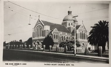
Print, Rose Stereograph Company, Sacred Heart Church, Kew, Vic, Twentieth Century
... sacred heart church -- cotham road -- kew (vic.)....) sacred heart church -- cotham road -- kew (vic.) catholic ...The history of the church goes back to 1872 when Jesuits purchased land in Walpole Street. By 1875 Archbishop Gould had laid a foundation stone on 14 February for a school. Early services for local Catholics were held in Richmond, Collingwood and later Hawthorn. By 1899 the land for the current church was purchased after a donation by Mr James Crotty of 3,000.00. The foundation stone was laid on 15 December 1918 by Archbishop Mannix. The dimensions of the church were to be 139 feet long by 77 feet wide with seating for 850 people. The cost of construction was 15,000.00. (Source: www.churchhistories.net.au )Sacred Heart Church, Kew, Vic., circa 1920-54. Photographic print of a Rose Stereograph Co. postcard in the State Library of Victoria collection.Inscription: The Rose Series P. 13053, Sacred Heart Church, Kew, Vic." Annotation in pencil: "KH-5. Foundation Stone laid 1918, completed 1921."churches -- kew (vic.), sacred heart church -- cotham road -- kew (vic.), catholic churches -- melbourne (vic.) -
 Kew Historical Society Inc
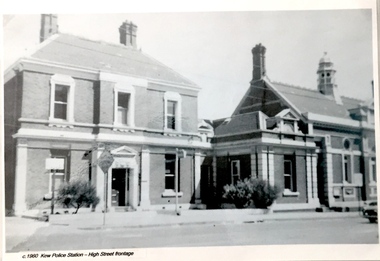
Postcard, Kew Police Station, c.1960
... at the junction of High Street and Cotham Roads in Kew. The frontages... at the junction of High Street and Cotham Roads in Kew. The frontages ...In c.1960, when the photograph was taken on which the postcard is based, both buildings were still owned by the Victorian Government and were a functioning police station and court house. In 1900, ownership of the post office had been transferred to the new Commonwealth Government. In the first decade of the twenty-first century, the police station and court house were offered for sale. They were subsequently purchased and renovated by the City of Boroondara. The Kew Historical Society raised over $5000,000 as a contribution to the restoration.Kew Police Station at left and Kew Court House at right. Monochrome (copied) postcard showing two buildings which are part of a larger complex (once including a post office) built by the Government of Victoria in 1888. The buildings are located at the junction of High Street and Cotham Roads in Kew. The frontages shown face High Street. "c.1960. Kew Police Station. High Street Frontage"kew court house -- high street -- kew (vic.), kew police station -- high street -- kew (vic.), public offices -- kew (vic), queen ann revival -- architectural style -
 Kew Historical Society Inc
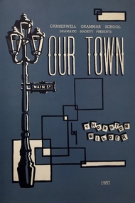
Programme, Camberwell Grammar School Dramatic Society, 'Our Town' / by Thornton Wilder, 1957
... the Kew City Hall (Cotham Road) were major locations in suburban ...The back page of the programme includes details of previous productions: 1950 - The Resignation of Mr. Bagsworth, The Shirt, 1951 - Richard of Bordeaux, 1952 - Ned Kelly, 1953 - Saint Joan, 1954 - Treasure Island 1955 - Toad of Toad Hall, and 1956 School for Scandal.The Kew Recreation Hall (Wellington Street) and later the Kew City Hall (Cotham Road) were major locations in suburban Melbourne in the postwar period for civic and private events including theatre productions and exhibitions. The Arthur Dear Collection (in conjunction with the scrapbooks compiled by Marion Tilley) provide a comprehensive snapshot of performing arts in Kew during the 1940s, 1950s and 1960s. The collection includes valuable data about performances, performers, directors etc., during this period. Theatre programme for a production of Our Town by the Camberwell Grammar School Dramatic Society. The 4-page programme includes a cast list and information about supernumeraries. arthur dear collection, theatre memorabilia, theatre programmes, camberwell grammar school dramatic society -
 Kew Historical Society Inc
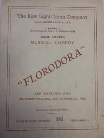
Programme - Theatre Programme, Florodora / by Leslie Stuart, 1952
... Street, and later the new Kew City Hall in Cotham Road ...The Kew Light Opera Company was formed in 1952. Its first production, held in the Kew Recreation Hall was Leslie Stuart's Florodora. In 1957, the Company was subsumed in the "Q" Theatre Guild.Arthur Henry Dear was an employee of the City of Kew, acting as Hall Keeper of the Kew Recreation Hall in Wellington Street, and later the new Kew City Hall in Cotham Road. The Arthur Dear Collection contains memorabilia - tickets, programmes, invitations - as well as his identification badge. Items in the collection dates from the 1940s to the 1960s. The Kew Recreation Hall (Wellington Street) and later the Kew City Hall (Cotham Road) were major locations in suburban Melbourne in the postwar period for civic and private events including theatre productions and exhibitions. The Arthur Dear Collection (in conjunction with the scrapbooks compiled by Marion Tilley) provide a comprehensive snapshot of performing arts in Kew during the 1940s, 1950s and 1960s. The collection includes valuable data about performances, performers, directors etc., during this period. Theatre programme for a production of Florodora in the Kew Recreation Hall by the Kew Light Opera Company. The 12-page programme includes profiles, a cast list and advertisements. An annotation on the acknowledgements page by Arthur Dear, the Hall Keeper, records that he was responsible for cleaning up the mess afterwardsarthur dear collection, performing arts -- kew -- victoria, kew recreation hall -- wellington street, theatre memorabilia, kew light opera company, florodora - leslie stuart -
 Kew Historical Society Inc
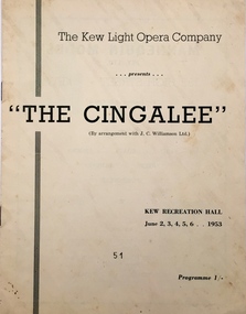
Programme - Theatre Programme, The Cingalee / by Lionel Monckton, 1953
... Street, and later the new Kew City Hall in Cotham Road ...The Kew Light Opera Company was formed in 1952. Its first production, held in the Kew Recreation Hall was Leslie Stuart's Florodora. In 1957, the Company was subsumed in the "Q" Theatre Guild.Arthur Henry Dear was an employee of the City of Kew, acting as Hall Keeper of the Kew Recreation Hall in Wellington Street, and later the new Kew City Hall in Cotham Road. The Arthur Dear Collection contains memorabilia - tickets, programmes, invitations - as well as his identification badge. Items in the collection dates from the 1940s to the 1960s. The Kew Recreation Hall (Wellington Street) and later the Kew City Hall (Cotham Road) were major locations in suburban Melbourne in the postwar period for civic and private events including theatre productions and exhibitions. The Arthur Dear Collection (in conjunction with the scrapbooks compiled by Marion Tilley) provide a comprehensive snapshot of performing arts in Kew during the 1940s, 1950s and 1960s. The collection includes valuable data about performances, performers, directors etc., during this period. Theatre programme for a production of The Cingalee in the Kew Recreation Hall by the Kew Light Opera Company. The 10-page programme includes profiles, a cast list and advertisements. arthur dear collection, performing arts -- kew -- victoria, kew recreation hall -- wellington street, city of kew, theatre memorabilia, the cingalee, kew light opera company -
 Kew Historical Society Inc
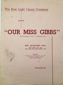
Programme - Theatre Programme, Our Miss Gibbs / by Lionel Monckton & Ivan Caryll, 1954
... Street, and later the new Kew City Hall in Cotham Road ...The Kew Light Opera Company was formed in 1952. Its first production, held in the Kew Recreation Hall was Leslie Stuart's Florodora. In 1957, the Company was subsumed in the "Q" Theatre Guild.Arthur Henry Dear was an employee of the City of Kew, acting as Hall Keeper of the Kew Recreation Hall in Wellington Street, and later the new Kew City Hall in Cotham Road. The Arthur Dear Collection contains memorabilia - tickets, programmes, invitations - as well as his identification badge. Items in the collection dates from the 1940s to the 1960s.The Kew Recreation Hall (Wellington Street) and later the Kew City Hall (Cotham Road) were major locations in suburban Melbourne in the postwar period for civic and private events including theatre productions and exhibitions. The Arthur Dear Collection (in conjunction with the scrapbooks compiled by Marion Tilley) provide a comprehensive snapshot of performing arts in Kew during the 1940s, 1950s and 1960s. The collection includes valuable data about performances, performers, directors etc., during this period. Theatre programme for a production of Our Miss Gibbs in the Kew Recreation Hall by the Kew Light Opera Company. The 4-page programme includes a cast list and a synopsis. 4 pp.arthur dear collection, kew light opera company, kew recreation hall, musicals, programmes, theatre, theatrical performances, performing arts, our miss gibbs -
 Kew Historical Society Inc
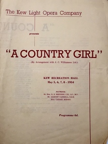
Programme - Theatre Programme, A Country Girl / by Lionel Monckton, 1954
... Street, and later the new Kew City Hall in Cotham Road ...The Kew Light Opera Company was formed in 1952. Its first production, held in the Kew Recreation Hall was Leslie Stuart's Florodora. In 1957, the Company was subsumed in the "Q" Theatre Guild.Arthur Henry Dear was an employee of the City of Kew, acting as Hall Keeper of the Kew Recreation Hall in Wellington Street, and later the new Kew City Hall in Cotham Road. The Arthur Dear Collection contains memorabilia - tickets, programmes, invitations - as well as his identification badge. Items in the collection dates from the 1940s to the 1960s. The Kew Recreation Hall (Wellington Street) and later the Kew City Hall (Cotham Road) were major locations in suburban Melbourne in the postwar period for civic and private events including theatre productions and exhibitions. The Arthur Dear Collection (in conjunction with the scrapbooks compiled by Marion Tilley) provide a comprehensive snapshot of performing arts in Kew during the 1940s, 1950s and 1960s. The collection includes valuable data about performances, performers, directors etc., during this period. Theatre programme for a production of A Country Girl in the Kew Recreation Hall by the Kew Light Opera Company. The 4-page programme includes a cast list and a synopsis. arthur dear collection, performing arts -- kew -- victoria, kew recreation hall -- wellington street, city of kew, theatre memorabilia, kew light opera company -
 Kew Historical Society Inc
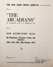
Programme - Theatre Programme, The Arcadians / by Mark Ambient & A.M. Thompson, 1955
... Street, and later the new Kew City Hall in Cotham Road ...The Kew Light Opera Company was formed in 1952. Its first production, held in the Kew Recreation Hall was Leslie Stuart's Florodora. In 1957, the Company was subsumed in the "Q" Theatre Guild.Arthur Henry Dear was an employee of the City of Kew, acting as Hall Keeper of the Kew Recreation Hall in Wellington Street, and later the new Kew City Hall in Cotham Road. The Arthur Dear Collection contains memorabilia - tickets, programmes, invitations - as well as his identification badge. Items in the collection dates from the 1940s to the 1960s. The Kew Recreation Hall (Wellington Street) and later the Kew City Hall (Cotham Road) were major locations in suburban Melbourne in the postwar period for civic and private events including theatre productions and exhibitions. The Arthur Dear Collection (in conjunction with the scrapbooks compiled by Marion Tilley) provide a comprehensive snapshot of performing arts in Kew during the 1940s, 1950s and 1960s. The collection includes valuable data about performances, performers, directors etc., during this period.Theatre programme for a production of The Arcadians in the Kew Recreation Hall by the Kew Light Opera Company. The 4-page programme includes a cast list and a synopsis. the arcadians, mark ambient, a.m. thompson, arthur dear collection, performing arts -- kew -- victoria, kew recreation hall -- wellington street, theatre memorabilia -
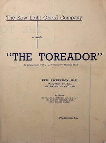 Kew Historical Society Inc
Programme - Theatre Programme, The Toreador / by Ivan Caryll & Lionel Monckton, 1955
... Street, and later the new Kew City Hall in Cotham Road ...The Kew Light Opera Company was formed in 1952. Its first production, held in the Kew Recreation Hall was Leslie Stuart's Florodora. In 1957, the Company was subsumed in the "Q" Theatre Guild.Arthur Henry Dear was an employee of the City of Kew, acting as Hall Keeper of the Kew Recreation Hall in Wellington Street, and later the new Kew City Hall in Cotham Road. The Arthur Dear Collection contains memorabilia - tickets, programmes, invitations - as well as his identification badge. Items in the collection dates from the 1940s to the 1960s. The Kew Recreation Hall (Wellington Street) and later the Kew City Hall (Cotham Road) were major locations in suburban Melbourne in the postwar period for civic and private events including theatre productions and exhibitions. The Arthur Dear Collection (in conjunction with the scrapbooks compiled by Marion Tilley) provide a comprehensive snapshot of performing arts in Kew during the 1940s, 1950s and 1960s. The collection includes valuable data about performances, performers, directors etc., during this period. Theatrical programme for a production of The Toreador in the Kew Recreation Hall by the Kew Light Opera Company. The 4-page programme includes a cast list and a synopsis. the toreador, ivan caryll, lionel monckton, arthur dear collection, performing arts -- kew -- victoria, kew recreation hall -- wellington street, city of kew, theatre memorabilia -
 Kew Historical Society Inc
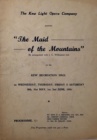
Programme - Theatre Programme, The Maid of the Mountains / by Harold Fraser-Simson, 1956
... Street, and later the new Kew City Hall in Cotham Road ...The Kew Light Opera Company was formed in 1952. Its first production, held in the Kew Recreation Hall was Leslie Stuart's Florodora. In 1957, the Company was subsumed in the "Q" Theatre Guild.Arthur Henry Dear was an employee of the City of Kew, acting as Hall Keeper of the Kew Recreation Hall in Wellington Street, and later the new Kew City Hall in Cotham Road. The Arthur Dear Collection contains memorabilia - tickets, programmes, invitations - as well as his identification badge. Items in the collection dates from the 1940s to the 1960s. The Kew Recreation Hall (Wellington Street) and later the Kew City Hall (Cotham Road) were major locations in suburban Melbourne in the postwar period for civic and private events including theatre productions and exhibitions. The Arthur Dear Collection (in conjunction with the scrapbooks compiled by Marion Tilley) provide a comprehensive snapshot of performing arts in Kew during the 1940s, 1950s and 1960s. The collection includes valuable data about performances, performers, directors etc., during this period. Theatre programme for a production of The Maid of the Mountains in the Kew Recreation Hall by the Kew Light Opera Company. The 4-page programme includes a cast list and a synopsis. arthur dear collection, kew light opera company, kew recreation hall, theatre - victoria, theatre - kew, the maid of the mountains, harold fraser-simson -
 Kew Historical Society Inc
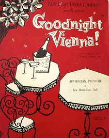
Programme - Theatre Programme, Goodnight Vienna! / by George Posford, 1956
... Street, and later the new Kew City Hall in Cotham Road ...The Kew Light Opera Company was formed in 1952. Its first production, held in the Kew Recreation Hall was Leslie Stuart's Florodora. In 1957, the Company was subsumed in the "Q" Theatre Guild.Arthur Henry Dear was an employee of the City of Kew, acting as Hall Keeper of the Kew Recreation Hall in Wellington Street, and later the new Kew City Hall in Cotham Road. The Arthur Dear Collection contains memorabilia - tickets, programmes, invitations - as well as his identification badge. Items in the collection dates from the 1940s to the 1960s. The Kew Recreation Hall (Wellington Street) and later the Kew City Hall (Cotham Road) were major locations in suburban Melbourne in the postwar period for civic and private events including theatre productions and exhibitions. The Arthur Dear Collection (in conjunction with the scrapbooks compiled by Marion Tilley) provide a comprehensive snapshot of performing arts in Kew during the 1940s, 1950s and 1960s. The collection includes valuable data about performances, performers, directors etc., during this period. Theatre programme for the Australian premiere of Goodnight Vienna! in the Kew Recreation Hall by the Kew Light Opera Company. The 12-page programme includes profiles, a cast list, a musical synopsis, and advertisements. goodnight vienna!, george posford, arthur dear collection, performing arts -- kew -- victoria, kew recreation hall -- wellington street, city of kew, theatre memorabilia -
 Kew Historical Society Inc
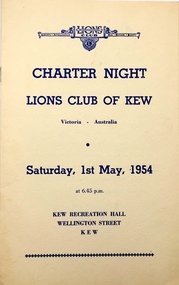
Programme, Charter Night: Lions Club of Kew, 1954
... in Wellington Street, and later the new Kew City Hall in Cotham Road ...The Kew Lions Club was formed in 1954 under the auspices of the Melbourne Lions ClubArthur Henry Dear was an employee of the City of Kew, acting as Hall Keeper of the Kew Recreation Hall in Wellington Street, and later the new Kew City Hall in Cotham Road. The Arthur Dear Collection contains memorabilia - tickets, programmes, invitations - as well as his identification badge. Items in the collection dates from the 1940s to the 1960s. Special programme held to on 1 May 1954 in the Kew Recreation Hall in recognition of the formation of the Kew Lions Club. The programme includes lists of officers, staff, and charter members. The food served on the night is described as well as the entertainers. 8 pp.arthur dear collection, lions club of kew, kew recreation hall - wellington street -- kew (vic.) -
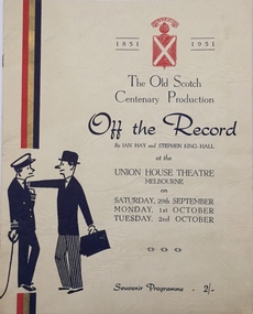 Kew Historical Society Inc
Programme - Theatre Programme, Off the Record / by Ian Hay and Stephen King-Hall, 1951
... , and later the new Kew City Hall in Cotham Road. The Arthur Dear ...The Old Scotch Collegians' Dramatic Society was formed in 1933. This performance celebrated the 100th anniversary of the College in 1951.Arthur Henry Dear was an employee of the City of Kew, acting as Hall Keeper of the Kew Recreation Hall in Wellington Street, and later the new Kew City Hall in Cotham Road. The Arthur Dear Collection contains memorabilia - tickets, programmes, invitations - as well as his identification badge. Items in the collection dates from the 1940s to the 1960s. Programme for the Old Scotch Centenary production of Off the Record by Ian Hay and Stephen King-Hall, performed in 1951 at the Union Theatre, Melbourne. The programme contains a history of the Old Scotch Collegians Dramatic Society (founded in 1933), a cast list, synopsis and cast profiles. 12 pp.old scotch collegians' dramatic society, union theatre - university of melbourne, arthur dear collection, theatre memorabilia -
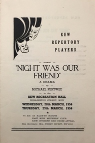 Kew Historical Society Inc
Programme - Theatre Programme, Night Was Our Friend / by Michael Pertwee, 1956
... in Cotham Road. The Arthur Dear Collection contains memorabilia ...From the early 1950s, the Kew Repertory Players performed more substantial, if less spectacular fare in the Recreation Hall, and later in the new Kew City Hall, after the former’s demolition in 1960. Their repertoire ranged from plays by Noel Coward to J.B. Priestley. Many of their programmes, the earliest from 1953, and the last from 1965, form part of our collection.Arthur Henry Dear was an employee of the City of Kew, acting as Hall Keeper of the Kew Recreation Hall in Wellington Street, and later the new Kew City Hall in Cotham Road. The Arthur Dear Collection contains memorabilia - tickets, programmes, invitations - as well as his identification badge. Items in the collection dates from the 1940s to the 1970s. The Kew Recreation Hall (Wellington Street) and later the Kew City Hall (Cotham Road) were major locations in suburban Melbourne in the postwar period for civic and private events including theatre productions and exhibitions. The Arthur Dear Collection (in conjunction with the scrapbooks compiled by Marion Tilley) provide a comprehensive snapshot of performing arts in Kew during the 1940s, 1950s and 1960s. The collection includes valuable data about performances, performers, directors etc., during this period.Programme issued by The Kew Repertory Players for a performance of Night Was Our Friend by Michael Pertwee. The performances took place in the Kew Recreation Hall in March 1956. The 4-page programme includes a cast list, a synopsis and advertisements for local businesses.night was our friend, michael pertwee, arthur dear collection, performing arts -- kew -- victoria, kew recreation hall -- wellington street, theatre memorabilia, kew repertory players -
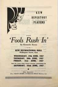 Kew Historical Society Inc
Programme - Theatre Programme, Fools Rush In / by Kenneth Horne, 1957
... in Cotham Road. The Arthur Dear Collection contains memorabilia ...From the early 1950s, the Kew Repertory Players performed more substantial, if less spectacular fare in the Recreation Hall, and later in the new Kew City Hall, after the former’s demolition in 1960. Their repertoire ranged from plays by Noel Coward to J.B. Priestley. Many of their programmes, the earliest from 1953, and the last from 1965, form part of our collection.Arthur Henry Dear was an employee of the City of Kew, acting as Hall Keeper of the Kew Recreation Hall in Wellington Street, and later the new Kew City Hall in Cotham Road. The Arthur Dear Collection contains memorabilia - tickets, programmes, invitations - as well as his identification badge. Items in the collection dates from the 1940s to the 1970s. The Kew Recreation Hall (Wellington Street) and later the Kew City Hall (Cotham Road) were major locations in suburban Melbourne in the postwar period for civic and private events including theatre productions and exhibitions. The Arthur Dear Collection (in conjunction with the scrapbooks compiled by Marion Tilley) provide a comprehensive snapshot of performing arts in Kew during the 1940s, 1950s and 1960s. The collection includes valuable data about performances, performers, directors etc., during this period. Programme issued by The Kew Repertory Players for a performance of Fools Rush In by Kenneth Horne. The performances took place in the Kew Recreation Hall in June 1957. The 4-page programme includes a cast list, a synopsis and advertisements for local businesses.fools rush in, kenneth horne, kew repertory players, arthur dear collection, performing arts -- kew -- victoria, kew recreation hall -- wellington street, theatre memorabilia