Showing 10939 items matching " plan"
-
 Stawell Historical Society Inc
Map, Section 5 (Taken from Plan No 959), 1894
Section 5 (Taken from Plan No 959)stawell -
 Federation University Historical Collection
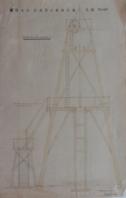
Plans, Plan of Truck Road for Kong Extended G. M. Company, 1887
3 hand drawn plans, 2 with orange and blue shading, of a truck road .1) hand drawn poppet head and road, timber specifications and iron bolts .2) hand drawn plan of poppet head .3) elevation and plan of mine workings plans, kong extended gold mining company, w. watson, poppet head, truck road -
 Queenscliffe Maritime Museum
Plan - Plan for a tide gauge house
An extract from the Board of Land and Works building estimates for 1858 shows an allocation of 500 Pounds for the construction of Tide Gauge Houses at various places. A copy of this plan was obtained from the Hydrographic Survey Office in Queenscliff. https://www.parliament.vic.gov.au/papers/govpub/VPARL1857-58NoB1.pdfCopy of a plan for a tide gauge house at Queenscliff 1858Clerk of works office Geelong 27 July 1858queenscliff, tide gauge house, plan -
 Eltham District Historical Society Inc
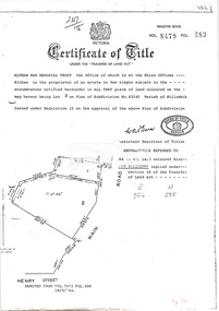
Document, Photocopy of Certificate of Title, Eltham War Memorial Trust, Lot 2, Plan of Subdivision No. 63242, Parish of Nillumbik; derived from Vol. 7073 Fol. 498, 18 May 1964, 1964
A4 photocopy Also Shire of Eltham plan of site with proposed security fence highlighted, c.1970 And Plan of Eltham Activity Centre, c.2010certificate of title, eltham war memorial, eltham war memorial trust -
Whitehorse Historical Society Inc.
Document, Municipal Public Health Plan, 1993
Municipal Public Health Plan 1994-96. Planning for a healthy future; improving our quality of life - Strategies/directions. Adopted by Council December 1993health services, city of nunawading, abbott, kevin -
Whitehorse Historical Society Inc.
Newspaper - Article, Cottage plan dumped, 26/01/1994
Article from Nunawading Post, 26/01/1994 'Cottage plan dumped'. Council voted unanimously to reject the proposed development plans for Schwerkolt Cottage.schwerkolt cottage, city of nunawading -
 Bacchus Marsh & District Historical Society
Map, Plan of land purchased by the Bacchus Marsh Shire Council from Mr. T. Low for a deviation of the Melbourne to Ballarat main road. 1877
The date of this plan is 1877 and the land indicted on it required for a road deviation is shaded in blue. It adjoins the Korkuperrimul Creek on one side which indicates the land is located just a few kilometers to the west of Bacchus Marsh. Single page map showing a portion of land purchased by the Bacchus Marsh Shire from Mr Thomas Low for the purpose of a road deviation. Land held by David Robertson is also shown on the map. Scale: 2 chains to 1 inch. Part of a set of maps which are pasted into a bound volume containing 76 maps or plans in total. High resolution digital image stored on BMDHS computer network. Surveyed by W. E. Standfield, Shire Engineer, Bacchus Marsh, 12/4/77bacchus marsh roads and streets, melbourne to ballarat road -
University of Melbourne, Burnley Campus Archives
Plan, Jordan Hansen, David Aldous Turf Memorial Garden Landscape Concept Plan, 2016
Landscape Concept Plan designed by Jordan Hansen for Andrew Smith LCP-001 David Aldous Turf memorial Garden 2016 - page 18. Scale 1:100andrew smith, jordan hansen, landscape design -
University of Melbourne, Burnley Campus Archives
Plan - Photocopy, Burnley School of Horticulture Detail Plan, 1977
Photocopy of plan of site excluding Field Station. Public Works Department Drawing No. 77.777.T2, Sheet No 2, dated 21.09.1977. Also 2 reduced size photocopies.ed smart, victoria public works department, burnley school of horticulture, buildings -
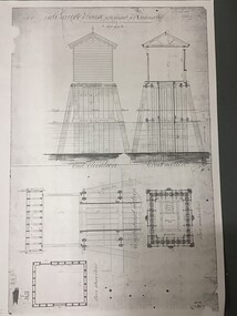
 University of Melbourne, Burnley Campus Archives
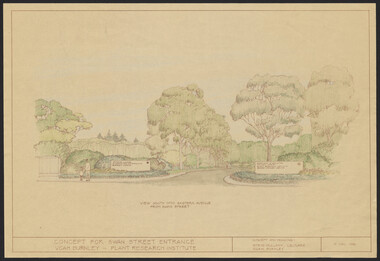
Plan, Landscape Plan Swan Street Entrance. VCAH Burnley and Plant Research Institute, 1988-1998
(1) Concept and Drawing by Steve Mullany, Lec turer V.C.A.H. Burnley 9 Dec 1988. Handdrawn. 1 coloured, 2 copies and 4 tracing paper sketches. (2) Landscape Plan by Steve Mullany 3 Feb 1989. Handdrawn. Includes Plant Plan. 2 copies on tracing paper. 3 copies original on paper with some additional notation. (30 Project Eden, Swan Street, Richmond - Landscape Plan LA2 Project No 682 by Mark McWha Pty Ltd Nov 1997. Photocopy. Includes Irrigation and Plant Schedule. (4) Swan St Frontage Planting Scheme by P. Tulk for AMRAD. Coloured. 19/2/1998. -
 Federation University Historical Collection
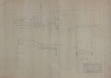
Plan, Ballarat School of Mines Preliminary Drawings for a Covered Way between Plumbing and Tippett Hall, 1962, 09/01/1962
Plan includes Ballarat School of Mines Administration Building and Tippett Hall (former Wesley Church)ballarat school of mines, architectural plan, plumbing, tippett hall, former wesley church, former ballarat school of mines museum -
 Federation University Historical Collection
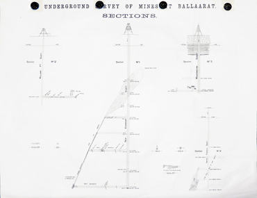
Plan, Underground Survey of Mines at Ballarat Sections
A plan showing the underground sections of the Washington Shaft, Smith's Freehold Shaft and the New Kohinoor Shaft.plans, mining, cgt, washington shaft, smith's freehold shaft, new kohinoor shaft, koh-i-nor -
 Federation University Historical Collection
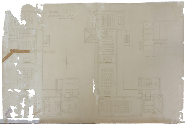
Plan, Ballarat Junior Technical School
The Ballarat Junior Technical School was a division of the Ballarat School of Mines, and was built in the SMB Campus.Copy of a plan of the first floor of the Ballarat Junior Technical School, a division of the Ballarat School of Mines. ballarat junior technical school, architectural plans -
Federation University Historical Collection
Plan, Former Ballarat Supreme Court
Plan of the Ballarat School of Mines Electrical Trades building, housed in the former Ballarat Supreme Courtballarat school of mines, electrical trades, former ballarat supreme court, architectural plans -
Federation University Historical Collection
Plan, Alterations to the Ballarat School of Mines Electrical Engineering Department, 1947, 18/02/1947
Copy of a plan showing the Ballarat School of Mines Electrical Engineering Department, and wrought iron gates.ballarat school of mines, electrical engineering, buildings, architectural drawing -
Glenelg Shire Council Cultural Collection
Plan, n.d
Port of Portland Authority Archivesport of portland archives -
Linton and District Historical Society Inc
Floor plan, Floor plan - Linton State School No. 880
A3 size photocopy showing floor plan and east side elevation of Linton State School building. The plan appears to show where new flooring will be required. The number W144563 is written in the top right hand corner. The plan is not clearly dated, however the initials "R. P." followed by the numbers "10/57" suggests that this plan may have been drawn up in 1957.linton state school no. 880, maps and plans, floor plan -
University of Melbourne, Burnley Campus Archives
Work on paper (item) - Student Work, Lucas McGarrigle, Landscape Design Plan, 2018
Made as an assignment for HORT90035, a subject at Burnley Horticultural College coordinated by Andrew Laidlaw. assignment, landscaping, burnley horticultural college, landscape construction and graphics, hort90035 -
 Flagstaff Hill Maritime Museum and Village
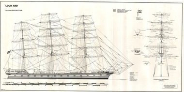
Document - Ship Model Plans, Loch Ard, October 1977
These two framed model ship plans are from more than 650 produced for the LOCH ARD Centenary (1878-1978) Commemoration Committee. These plans were originally researched, designed and distributed in 1977 to assist entrants in the Committee’s Ship Model Competition. The competition was arranged as a means of creating public interest and awareness for the 100th anniversary of the tragic LOCH ARD shipwreck on Victoria’s south west coast in 1878. The main subject specified for modelling was “The Loch Ard ― Iron Wool Clipper 1873”. “The plans were drawn by Mr P Webb to the order of the Committee through Mr P Williams, organizer of the competition. The details were based on all available information which resulted in considerable historical research…and received favourable comment from model makers because of their attention to detail…In excess of 650 sets of plans were sold before entries closed…Many plans were probably purchased by collectors and interested persons for historical reference. An illustrated historical story sheet…was prepared and enclosed with the plans…” (‘Loch Ard Shipwreck Centenary 1878-1978 Report’, November 1978). An example of the attention to historical detail delivered on the plans is the inclusion of the following useful information about the original vessel: “Tonnage….1,693 G.R.T., 1,624 N.R.T. Builders….Charles Connell & Co., Ltd., Scotstoun, 1873. Owners….General Shipping Co., Glasgow, (Aitken Lilburn & Co., Ltd.)”. The quality of research and drafting makes these framed copies of considerable interpretive value to related items from the LOCH ARD shipwreck on display at Flagstaff Hill. They were originally mass produced but are now out of print. Flagstaff Hill retains other (unframed) copies in storage. The plans, in conjunction with the scale Ship Model of the LOCH ARD also on display, are of interpretive significance to Flagstaff Hill Maritime Village. The plans provide historical and technological context to artefacts from the shipwreck, increasing understanding and appreciation of those objects. Flagstaff Hill’s collection of artefacts from LOCH ARD is significant for being one of the largest collections of artefacts from this shipwreck in Victoria. It is significant for its association with the shipwreck, which is on the Victorian Heritage Register (VHR S417). The collection is significant because of the relationship between the objects, as together they have a high potential to interpret the story of the LOCH ARD. The LOCH ARD collection is archaeologically significant as the remains of a large international passenger and cargo ship. The LOCH ARD collection is historically significant for representing aspects of Victoria’s shipping history and its potential to interpret sub-theme 1.5 of Victoria’s Framework of Historical Themes (living with natural processes). The collection is also historically significant for its association with the LOCH ARD, which was one of the worst and best known shipwrecks in Victoria’s history. Two framed model ship plans of the LOCH ARD. These are detailed and researched plans from the original vessel, drawn to scale and printed on good quality paper, and framed behind glass to be hung on display. One slightly smaller plan “Lines, Decks and Details” portrays the hull lines as a body plan (straight on at the bow), a sheer plan (full side view), and a half breadth plan (a top-down view of deck to keel), as well as two top-down views of the upper decks and main deck with fittings and details of specific fixtures. One slightly larger “Sail and Rigging Plan” presents a side on, above deck view of masts and shrouds and a front on, above deck view showing “Elevation of Mainmast Looking Aft”. Each plan bears the draftsman’s initials and date of completion (“P.A.W. 10/77”). The larger plan also includes a boxed label attributing the project to the “LOCH ARD CENTENARY Commemoration Committee Ship Model Competition.”Smaller plan: heading “LOCH ARD: LINES, DECKS and DETAILS”; initials “P.A.W. 10/77”. Larger plan: heading “LOCH ARD: SAIL and RIGGING PLAN”; initials “P.A.W. 10/77”; label “LOCH ARD CENTENARY Commemorative Committee Ship Model Competition”. flagstaff hill, warrnambool, shipwrecked coast, flagstaff hill maritime museum, maritime museum, shipwreck coast, flagstaff hill maritime village, great ocean road, loch line, loch ard, captain gibbs, eva carmichael, tom pearce, glenample station, mutton bird island, loch ard gorge, ship model plans, loch ard model plans, sailing ship, loch ard centenary -
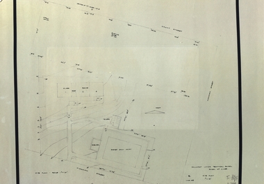
University of Melbourne, Burnley Campus Archives
Plan - Coloured plan, Plan of Burnley Gardens, 1929?
Layout of gardens, farm buildings, orchard, etc. overlaid on part of Lands Department map. See paper catalogue for full descriptionPart of larger plan (Lands Department Parish Plan). Partly hand-drawn. Area bounded by Yarra River, Swan St, Glen Iris railway line. Shows Burnley Gardens layout, handwritten amendments and explanation of existing and proposed structures including: Pavilion, sketch of unbuilt Administrative Building, poultry yard, contours of old orchard, sketch for Plant Research Institute, ditch, silo, milking shed, laying pens. See aboveburnley gardens, pavilion, burnley school of horticulture, farm buildings, poultry -
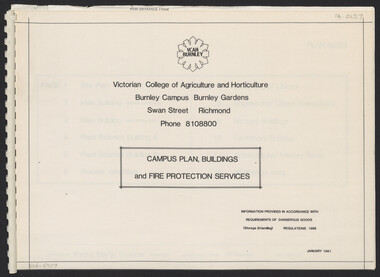 University of Melbourne, Burnley Campus Archives
Plan, Campus Plan, Buildings and Fire Protection Services
site plan, buildings, administration building, plant science laboratories, quad, library, student amenities building, engineering, urban horticulture, nursery -
Federation University Historical Collection
Plan, Crown Lands Department Melbourne, Parish of Clarkesdale, County of Grenville
Geolgical plan.clarkesdake, berringa, staffordshire reef, piggoreet -
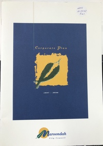 Ringwood and District Historical Society
Book, Maroondah City Council Corporate Plan 1997-2000, 2000
Maroondah City Council Corporate Plan 1997-2000 -
 Federation University Historical Collection
Plan (copy), Ballarat Girls' Junior Technical School plan, 1958, 06/1958
Site plan showing the Ballarat Junior Technical Schoolballarat girls' junior technical school, ballarat girls' technical school, hickman street, white flat -
University of Melbourne, Burnley Campus Archives
Document, Field Nursery plan, 1990
Plan of field nursery with lists of fruit trees, 28pp.field nursery, plans, fruit trees -
University of Melbourne, Burnley Campus Archives
Document, Strategic Plan 1995-6 Burnley College, 1995
Draft of Strategic Plan + some hand-written notesstrategic plan, burnley college, 1995 -
Whitehorse Historical Society Inc.
Article, $76,000 plan for Mitcham property, 1993
An open space development is planned for the Hale property in MitchamAn open space development is planned for the Hale property in MitchamAn open space development is planned for the Hale property in Mitchamcity of nunawading, hale property, buckanbe park -
Whitehorse Historical Society Inc.
Pamphlet, Nunawading 1999 - a structure plan, 1988
City of Nunawading - plan for structure, operation of the city by 1999.City of Nunawading - plan for structure, operation of the city by 1999.City of Nunawading - plan for structure, operation of the city by 1999.town planning, city of nunawading -
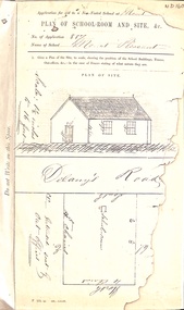 Whitehorse Historical Society Inc.
Map, Mt Pleasant School Plan, 1860
Plan of proposed school and site (Mount Pleasant School)education, mount pleasant school, no. 1022, delaney's road, vermont, non-vested schools -
Southern Sherbrooke Historical Society Inc.
book, "Lysterfield Lake Park, Proposed Recreation Use Plan", Jun-86
A proposed plan for the recreational use of Lysterfield Lake Park.lysterfield lake park