Showing 489 items
matching planning schemes
-
 Wodonga & District Historical Society Inc
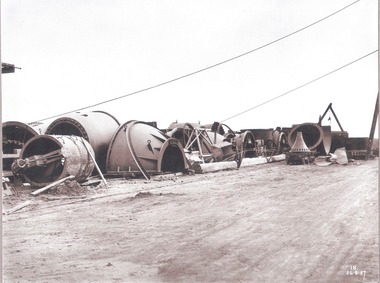
Album - Hume Reservoir Australia Album - Needle valves, August 1927
This set of photos is from a leather bound album bearing the inscription "HUME RESERVOIR AUSTRALIA" plus 'The Rt. Hon. L. C. M. S. Amery, P. C., M .P.' all inscribed in gold. It was presented to The Rt. Hon. L. C. M. S. Amery, P. C., M. P, Secretary of State for Dominion Affairs on the occasion of his visit to the Hume Reservoir on 2nd November 1927. This album is of local and national significance as it documents the planning and development of the Hume Reservoir up to 1927. It was the largest water reservoir in the British Empire. The album records the pioneering engineering work that went into its construction.DEPARTMENT OF PUBLIC WORKS, N.S.W. RIVER MURRAY WATERS SCHEME. HUME RESERVOIR. 34. Needle Valves. Some of the needle valves in parts stacked ready for removal by the cableway to their positions on the outlets. There are seven of these, 7 feet 6 inches in diameter. The heaviest single part weighs about 10 tons. New South Wales. August 1927. A needle valve is a type of valve which can be used to regulate flow of a substance, usually either gas or water, through an appliance or system. The unique feature of the value is the inclusion of a small plunger, with a shape akin to a needle.hume reservoir australia, river murray waters scheme, hume reservoir construction -
 Wodonga & District Historical Society Inc
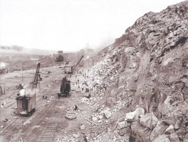
Album - Hume Reservoir Australia Album - View along the face of the quarry, August 1927
This set of photos is from a leather bound album bearing the inscription "HUME RESERVOIR AUSTRALIA" plus 'The Rt. Hon. L. C. M. S. Amery, P. C., M .P.' all inscribed in gold. It was presented to The Rt. Hon. L. C. M. S. Amery, P. C., M. P, Secretary of State for Dominion Affairs on the occasion of his visit to the Hume Reservoir on 2nd November 1927. This album is of local and national significance as it documents the planning and development of the Hume Reservoir up to 1927. It was the largest water reservoir in the British Empire. The album records the pioneering engineering work that went into its construction.DEPARTMENT OF PUBLIC WORKS, N.S.W. RIVER MURRAY WATERS SCHEME. HUME RESERVOIR. 35. Quarry. View along the face of the quarry. Granite is being quarried here for the concrete material. Blocks from 2-8 tons in weight are reserved for “plums”. Quantities of large size spalls are sent to Victoria for the toe of the embankment and other purposes but the greatest proportion of the stone is crushed at the quarry to 2½ inches gauge for concrete aggregate. Two steam navvies and two steam travelling cranes are at work on the face. New South Wales. August 1927.hume reservoir australia, river murray waters scheme, hume reservoir construction -
 Wodonga & District Historical Society Inc
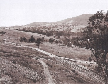
Album - Hume Reservoir Australia Album - Valley of the Murray to be crossed by the Bethanga Bridge 1927
This set of photos is from a leather bound album bearing the inscription "HUME RESERVOIR AUSTRALIA" plus 'The Rt. Hon. L. C. M. S. Amery, P. C., M .P.' all inscribed in gold. It was presented to The Rt. Hon. L. C. M. S. Amery, P. C., M. P, Secretary of State for Dominion Affairs on the occasion of his visit to the Hume Reservoir on 2nd November 1927. This album is of local and national significance as it documents the planning and development of the Hume Reservoir up to 1927. It was the largest water reservoir in the British Empire. The album records the pioneering engineering work that went into its construction.DEPARTMENT OF PUBLIC WORKS, N.S.W. RIVER MURRAY WATERS SCHEME. HUME RESERVOIR. 36. Valley of the Murray to be crossed by the Bethanga Bridge described in the next photograph. (WHS 00731) This view shows the marshalling sidings for trucks below the Quarry, New South Wales, and the branch line to the site of the bridge.hume reservoir australia, river murray waters scheme, hume reservoir construction -
 Wodonga & District Historical Society Inc
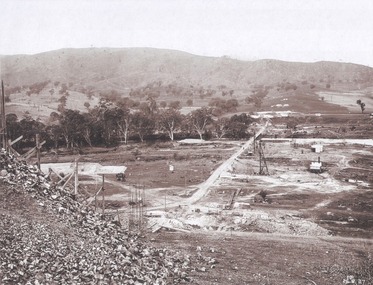
Album - Hume Reservoir Australia Album - Bethanga Bridge Site, August 1927
This set of photos is from a leather bound album bearing the inscription "HUME RESERVOIR AUSTRALIA" plus 'The Rt. Hon. L. C. M. S. Amery, P. C., M .P.' all inscribed in gold. It was presented to The Rt. Hon. L. C. M. S. Amery, P. C., M. P, Secretary of State for Dominion Affairs on the occasion of his visit to the Hume Reservoir on 2nd November 1927. This album is of local and national significance as it documents the planning and development of the Hume Reservoir up to 1927. It was the largest water reservoir in the British Empire. The album records the pioneering engineering work that went into its construction.DEPARTMENT OF PUBLIC WORKS, N.S.W. RIVER MURRAY WATERS SCHEME. HUME RESERVOIR. 37. Bethanga Bridge Site. A bridge is being built to cross the Reservoir to serve a large area of country which will be cut off from its natural outlets by the submergence of existing bridges when the Reservoir is in being. The site of the bridge is nearly a mile up the Murray from the Hume Reservoir Quarry. Its length will be approximately half a mile. There will be nine spans of 269 feet with steel truss girders resting on concrete pillars. Some of the pillars are founded on rock while others will rest on nests of reinforced concrete piles. The foundations and concrete piers are in the hands of the Victorian Constructing Authority and the superstructure in those of the New South Wales Authority. August 1927.hume reservoir australia, river murray waters scheme, hume reservoir construction -
 Wodonga & District Historical Society Inc
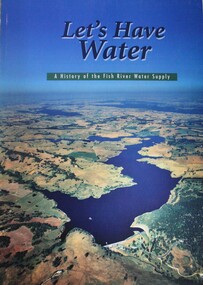
Book - Let's Have Water - A history of the Fish River Water Supply, Robin McLachlan, Denis Barrett, Jack Domis, Nick Welling, 1997
A history of the development of the management of the Fish River Water Supply Scheme in Central NSW. The scheme extends across the local government areas of the Shire of Oberon, the City of Lithgow and the City of the Blue Mountains.non-fictionA history of the development of the management of the Fish River Water Supply Scheme in Central NSW. The scheme extends across the local government areas of the Shire of Oberon, the City of Lithgow and the City of the Blue Mountains.water nsw, fish river region nsw, oberon dam, water resources development nsw australia -
 Melbourne Legacy
Document - Speech, Moments in the History of Legacy 1987 (H59), 1987
A copy of an address given at a Foundation Day Luncheon by a long standing Legatee and past President Legatee Rob Allison. He had joined Legacy in 1950, and he comments that only 5 members remain active that were with him in 1950. In 1950 they were all posted as member of various committees, he got Welfare and Friday night girls' classes. There were 9 boys' classes throughout Melbourne, and girls' twice a week at Legacy Headquarters at 24 Market St. There were 230 active members and each legatee had 4 or 5 families with children. He mentions that in 1950 the President was 62 years old but only 5 years after the end of the war, the tide had begun to turn towards the 39ers. (He called the older legatees '1914ers' or 'the Bow and Arrow boys'). He applauded the 'founding fathers' for limiting the numbers of members, in 1929 it was 230 and in 1959 a limit of 300. They used a classification method to classify the members so they had a diverse range of skills and community representation. Areas were: Production, Distribution, Services Public Authority, Services Other, and Board List. The President had a Secret Committee of 3, no one knew who was on the committee, even those members didn't know the identity of the other 2. This committee vetted the background and integrity of new members. In 1950 the budget was £27,000 plus a capital budget of £3,500. Legatee Allison tells a good story of his induction into Legacy, including his wife joining other Legatees wives in fundraising. In 1951 Comradeship meetings moved to Thursday nights at the instigation of Burt Nathan. 'Birthday boy' invitations started in 1958 when John Cooper was Chairman of the Comradeship. After some years of discussion the first paid Social Worker was employed in 1953 and as a result her efforts the first Senior Widows' Group got underway. Until the 1950s Legacy had always found the money it required, from big companies, wealthy members of the community, Estates, or Trusts. In 1951 it tried to copy a Sydney Legacy idea (Certificate of Adoption Plan) and called it 'The Endowment Scheme'. Other fundraisers included films, premiere showing and musicals were very much a part of the social life of Legatees. One premiere show in 1952, 'The Greatest Show on Earth' was sold at £100 a double. In 1959 Sir Frank and Lady Tait were kind enough for give us a premiere of 'My Fair Lady'. As the 50s progressed cash flow was not enough and it was decided in 1957 to have the first public appeal (he says 1957 but it was 1956). The first Badge day was 1958 (according to this account). He says it grossed £21,000 (net £17,000). And the Legacy story was becoming better known. 'Legacy has never been a one man band. The strength has been in the resourceful ability of those of its members.' He was well placed to tell the story of the donation towards Dureau House. BG Corporation in New York used 'Brown and Dureau' as agents in Melbourne for their spark plug manufacturing (for the American aircraft based in Australia during the war). A royalty of two shillings and sixpence was agreed. The entrepreneur President of BG Corporation was Richard Goldsmith. L/ Grat Grattan had a friend Mr Edwards who was managing director at Brown and Dureau and heard of the desire by Goldsmith to leave a permanent memorial to ex-servicemen in Australia (Children's Hospital was considered). Grat took Edwards to Market St and showed him the inadequacy of the building. It was agreed if Melbourne Legacy could come up with a purchased building in 10 days they would get the money needed. The property purchased was 'Storey Hall' in Swanston St (also called Hibernian Hall in other documents). After the war it turned out not to be suitable and a new building was required. The speaker is identified as Rob Allison based on two things; at one stage he refers to himself as 'Rob' and this copy of the speech has been faxed to Legacy from the offices of John Allison Monkhouse. Another copy of this address has been located with the date of September 1988 that was filed with information on Past Presidents and the lives prominent legatees. The notation H59 in black pen shows that it was part of the archive project that was trying to capture the history of Legacy. A record of Legatee Rob Allison speaking at a Legacy luncheon about significant events since he joined in 1950. Speakers at Legacy luncheons were from very different walks of life and the subjects spoken on were many and varied. Foundation Day was celebrated with a special luncheon.White A4 photocopy with black type x 8 pages of an address about Legacy history written in 1987.Handwritten H59 in black pen. history, speech, foundation day, past presidents, dureau house, rob allison -
 Bacchus Marsh & District Historical Society
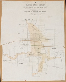
Map, Bacchus Marsh District (A). Proposed Irrigation and Water Supply Trust. Plan shewing boundaries of Trust District
The 1886 Irrigation Act in Victoria introduced the first legislation in Australia designed to enable the creation of a detailed scheme for agricultural irrigation. Part of the legislation saw the use of government funds for local irrigation projects. These local projects were managed by local irrigation trusts. The Bacchus Marsh Irrigation and Water Supply Trust was formed in 1889. This map depicts the proposed area of the Trust.Printed paper map of the proposed Bacchus Marsh Irrigation and Water Supply district. Circa 1889. Plan showing boundaries of Trust District. The District lies within the Parishes of Korkuperrimul, Merrimu, Parwan and Gorrockburkchap in the Counties of Bourke and Grant. At the top of the map above its title is the letter 'A; in capital lettering. Scale: 40 Chains = 1 inch.irrigation, water supply, bacchus marsh irrigation and water supply trust -
 Eltham District Historical Society Inc
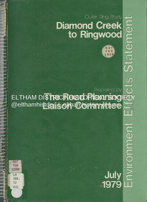
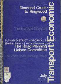
Book, The Road Planning Liaison Committee, Outer Ring Study, Diamond Creek to Ringwood: Environmental Effects Statement, July 1979
... to the Metropolitan Planning Scheme to preserve the option to implement ...Prepared by The Road Planning Liaison Committee. The Outer Ring Study, Diamond Creek to Ringwood was a long term planning study carried out under the direction of the Road Planning Liaison Committee for the Government of Victoria. .. The basic aim of the .. Study was to determine the most appropriate future road system in the area between Diamond Creek and Ringwood, consistent with local and regional concerns and the environment of the area, with a view to seeking an emendment to the Metropolitan Planning Scheme to preserve the option to implement an appropriate road system some time in the future if this was considered necessary.non-fictionPrepared by The Road Planning Liaison Committee. The Outer Ring Study, Diamond Creek to Ringwood was a long term planning study carried out under the direction of the Road Planning Liaison Committee for the Government of Victoria. .. The basic aim of the .. Study was to determine the most appropriate future road system in the area between Diamond Creek and Ringwood, consistent with local and regional concerns and the environment of the area, with a view to seeking an emendment to the Metropolitan Planning Scheme to preserve the option to implement an appropriate road system some time in the future if this was considered necessary.roads, freeways, melbourne ring road -
 Eltham District Historical Society Inc
Book, The Joint Road Planning Group, Outer Ring Study, Diamond Creek to Ringwood: Technical Report Transport and Economic Evaluation, July 1979
... to seeking an emendment to the Metropolitan Planning Scheme ...Prepared for The Road Planning Liaison Committee by The Joint Road Planning Group. The Outer Ring Study, Diamond Creek to Ringwood was a long term planning study carried out under the direction of the Road Planning Liaison Committee for the Government of Victoria. .. The basic aim of the .. Study was to determine the most appropriate future road system in the area between Diamond Creek and Ringwood, consistent with local and regional concerns and the environment of the area, with a view to seeking an emendment to the Metropolitan Planning Scheme to preserve the option to implement an appropriate road system some time in the future if this was considered necessary. This technical report discusses, in detail, the transport and economic aspects of the investigation.. the techniques used take into account the long term implications of a range of possible travel cost policies and options and land use strategies.non-fictionPrepared for The Road Planning Liaison Committee by The Joint Road Planning Group. The Outer Ring Study, Diamond Creek to Ringwood was a long term planning study carried out under the direction of the Road Planning Liaison Committee for the Government of Victoria. .. The basic aim of the .. Study was to determine the most appropriate future road system in the area between Diamond Creek and Ringwood, consistent with local and regional concerns and the environment of the area, with a view to seeking an emendment to the Metropolitan Planning Scheme to preserve the option to implement an appropriate road system some time in the future if this was considered necessary. This technical report discusses, in detail, the transport and economic aspects of the investigation.. the techniques used take into account the long term implications of a range of possible travel cost policies and options and land use strategies.melbourne ring road, roads, freeways -
 Falls Creek Historical Society
Photograph - Bogong Alpine Village Houses 1946
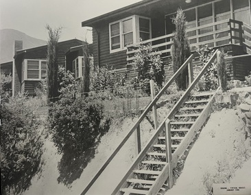
The images in the Bogong Village Collection were displayed in Bogong Jack’s Tavern for over 20 years and were donated to the Falls Creek Museum when the Tavern closed in 2021. In 1939, the State Electricity Commission of Victoria established a field headquarters at Bogong to house workers and their families for the Kiewa Hydroelectric Scheme which ran from the 1930s to the 1960s. The workmen's camp was originally started with tents and was called Junction Camp. By 1947, the village supported 300 workers and their families. It included 40 houses, a hostel for single staff, a post office, a police station, a medical centre, and a primary school. The staff hostel was known as Kiewa House. At the completion of the Scheme, in the 1960s, the village was opened to public/tourism use. In 1968 the Victorian Education Department acquired the camp buildings and four houses from the State Electricity Commission of Victoria to establish an Outdoor Education Centre which operated for over 50 years. The Kiewa Hydroelectric Scheme was privatized in the 1990s and sold to Southern Hydro, before being acquired by AGL in 2005. In 2023 the Grollo Group signed a 73 year sublease on Bogong Village and has plans for its redevelopment as a workers’ village.These images are significant because they capture the development of Bogong Village as an important element of the Kiewa Hydroelectric Scheme in Victoria.Two black and white images featuring houses in Bogong Village in January 1946. They are constructed of weatherboard, with brick chimneys and tin roofs. Timber steps lead up to the front door and a garden has been planted in front of the house.bogong alpine village, bogong high plains, bogong houses 1946 -
 Falls Creek Historical Society
Photograph - Bogong Alpine Village 1944
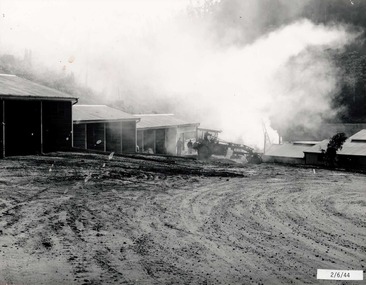
The images in the Bogong Village Collection were displayed in Bogong Jack’s Tavern for over 20 years and were donated to the Falls Creek Museum when the Tavern closed in 2021. In 1939, the State Electricity Commission of Victoria established a field headquarters at Bogong to house workers and their families for the Kiewa Hydroelectric Scheme which ran from the 1930s to the 1960s. The workmen's camp was originally started with tents and was called Junction Camp. By 1947, the village supported 300 workers and their families. It included 40 houses, a hostel for single staff, a post office, a police station, a medical centre, and a primary school. The staff hostel was known as Kiewa House. At the completion of the Scheme, in the 1960s, the village was opened to public/tourism use. In 1968 the Victorian Education Department acquired the camp buildings and four houses from the State Electricity Commission of Victoria to establish an Outdoor Education Centre which operated for over 50 years. The Kiewa Hydroelectric Scheme was privatized in the 1990s and sold to Southern Hydro, before being acquired by AGL in 2005. In 2023 the Grollo Group signed a 73 year sublease on Bogong Village and has plans for its redevelopment as a workers’ village.These images are significant because they capture the development of Bogong Village as an important element of the Kiewa Hydroelectric Scheme in Victoria.A collection of four black and white images capturing the weather conditions in the Bogong area in June 1944bogong alpine village, bogong high plains, bogong june 1944 -
 Falls Creek Historical Society
Photograph - Bogong Alpine Village 1947
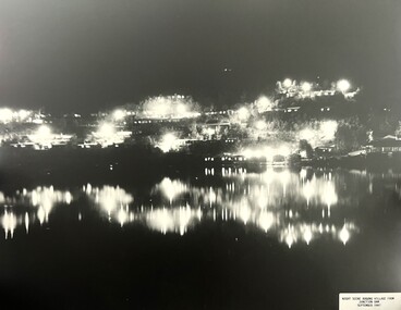
The images in the Bogong Village Collection were displayed in Bogong Jack’s Tavern for over 20 years and were donated to the Falls Creek Museum when the Tavern closed in 2021. In 1939, the State Electricity Commission of Victoria established a field headquarters at Bogong to house workers and their families for the Kiewa Hydroelectric Scheme which ran from the 1930s to the 1960s. The workmen's camp was originally started with tents and was called Junction Camp. By 1947, the village supported 300 workers and their families. It included 40 houses, a hostel for single staff, a post office, a police station, a medical centre, and a primary school. The staff hostel was known as Kiewa House. At the completion of the Scheme, in the 1960s, the village was opened to public/tourism use. In 1968 the Victorian Education Department acquired the camp buildings and four houses from the State Electricity Commission of Victoria to establish an Outdoor Education Centre which operated for over 50 years. The Kiewa Hydroelectric Scheme was privatized in the 1990s and sold to Southern Hydro, before being acquired by AGL in 2005. In 2023 the Grollo Group signed a 73 year sublease on Bogong Village and has plans for its redevelopment as a workers’ village.These images are significant because they capture the development of Bogong Village as an important element of the Kiewa Hydroelectric Scheme in Victoria.Two black and white images capturing Bogong Village by night and the spillway at Junction Dam.bogong alpine village, bogong high plains, bogong 1947 -
 Falls Creek Historical Society
Photograph - Jack Maddison Leading horses on the Bogong High Plain
The images in the Bogong Village Collection were displayed in Bogong Jack’s Tavern for over 20 years and were donated to the Falls Creek Museum when the Tavern closed in 2021. In 1939, the State Electricity Commission of Victoria established a field headquarters at Bogong to house workers and their families for the Kiewa Hydroelectric Scheme which ran from the 1930s to the 1960s. The workmen's camp was originally started with tents and was called Junction Camp. By 1947, the village supported 300 workers and their families. It included 40 houses, a hostel for single staff, a post office, a police station, a medical centre, and a primary school. The staff hostel was known as Kiewa House. At the completion of the Scheme, in the 1960s, the village was opened to public/tourism use. In 1968 the Victorian Education Department acquired the camp buildings and four houses from the State Electricity Commission of Victoria to establish an Outdoor Education Centre which operated for over 50 years. The Kiewa Hydroelectric Scheme was privatized in the 1990s and sold to Southern Hydro, before being acquired by AGL in 2005. In 2023 the Grollo Group signed a 73 year sublease on Bogong Village and has plans for its redevelopment as a workers’ village. John Maddison and his wife Mary Padman emigrated from London to Australia in 1850 with their five sons. Jack (John James William Maddison) was one of their great grandsons. In 1877 Jack’s grandfather George Maddison selected land between the East and West Kiewa branches of the Kiewa River - known as the "Island". It is now known as Mount Beauty. The Maddison family built Aertex Hut at the top of T Spur at Mt. Bogong for use when grazing cattle. It later became known as Maddison's Hut. Staircase Spur walking track at Bogong was formerly known as Maddison’s Track as it is the path once used by the Maddison family to drive their cattle on to the high plains. These images are significant because they feature the son of a pioneering family on the Bogong High Plains.A black and white photograph of Jack Maddison leading horses on the Bogong High Plains.bogong alpine village, bogong high plains, maddison family mt beauty, maddison's hut, aertex hut, -
 Falls Creek Historical Society
Photograph - Bogong Alpine Village and Howman's Dam Camp 1948
The images in the Bogong Village Collection were displayed in Bogong Jack’s Tavern for over 20 years and were donated to the Falls Creek Museum when the Tavern closed in 2021. In 1939, the State Electricity Commission of Victoria established a field headquarters at Bogong to house workers and their families for the Kiewa Hydroelectric Scheme which ran from the 1930s to the 1960s. The workmen's camp was originally started with tents and was called Junction Camp. By 1947, the village supported 300 workers and their families. It included 40 houses, a hostel for single staff, a post office, a police station, a medical centre, and a primary school. The staff hostel was known as Kiewa House. At the completion of the Scheme, in the 1960s, the village was opened to public/tourism use. In 1968 the Victorian Education Department acquired the camp buildings and four houses from the State Electricity Commission of Victoria to establish an Outdoor Education Centre which operated for over 50 years. The Kiewa Hydroelectric Scheme was privatized in the 1990s and sold to Southern Hydro, before being acquired by AGL in 2005. In 2023 the Grollo Group signed a 73 year sublease on Bogong Village and has plans for its redevelopment as a workers’ village.These images are significant because they capture the development of Bogong Village as an important element of the Kiewa Hydroelectric Scheme in Victoria.Two images capturing the depiction Bogong Village and the Howman's Dam Camp 1948bogong alpine village, bogong high plains, bogong 1947 -
 Falls Creek Historical Society
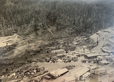
Photograph - Aerial View of Bogong Alpine Village
The images in the Bogong Village Collection were displayed in Bogong Jack’s Tavern for over 20 years and were donated to the Falls Creek Museum when the Tavern closed in 2021. In 1939, the State Electricity Commission of Victoria established a field headquarters at Bogong to house workers and their families for the Kiewa Hydroelectric Scheme which ran from the 1930s to the 1960s. The workmen's camp was originally started with tents and was called Junction Camp. By 1947, the village supported 300 workers and their families. It included 40 houses, a hostel for single staff, a post office, a police station, a medical centre, and a primary school. The staff hostel was known as Kiewa House. At the completion of the Scheme, in the 1960s, the village was opened to public/tourism use. In 1968 the Victorian Education Department acquired the camp buildings and four houses from the State Electricity Commission of Victoria to establish an Outdoor Education Centre which operated for over 50 years. The Kiewa Hydroelectric Scheme was privatized in the 1990s and sold to Southern Hydro, before being acquired by AGL in 2005. In 2023 the Grollo Group signed a 73 year sublease on Bogong Village and has plans for its redevelopment as a workers’ village.These images are significant because they capture the development of Bogong Village as an important element of the Kiewa Hydroelectric Scheme in Victoria.An aerial view of Bogong Village and surrounds, date unknown.bogong alpine village, bogong high plains, aerial photos bogong village -
 Falls Creek Historical Society
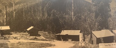
Photograph - Bogong Alpine Village 1940
The images in the Bogong Village Collection were displayed in Bogong Jack’s Tavern for over 20 years and were donated to the Falls Creek Museum by the Liz Krien & the Bogong Village Trust Board when the Tavern closed in 2021. In 1939, the State Electricity Commission of Victoria established a field headquarters at Bogong to house workers and their families for the Kiewa Hydroelectric Scheme which ran from the 1930s to the 1960s. The workmen's camp was originally started with tents and was called Junction Camp. By 1947, the village supported 300 workers and their families. It included 40 houses, a hostel for single staff, a post office, a police station, a medical centre, and a primary school. The staff hostel was known as Kiewa House. At the completion of the Scheme, in the 1960s, the village was opened to public/tourism use. In 1968 the Victorian Education Department acquired the camp buildings and four houses from the State Electricity Commission of Victoria to establish an Outdoor Education Centre which operated for over 50 years. The Kiewa Hydroelectric Scheme was privatized in the 1990s and sold to Southern Hydro, before being acquired by AGL in 2005. In 2023 the Grollo Group signed a 73 year sublease on Bogong Village and has plans for its redevelopment as a workers’ village.These images are significant because they capture the development of Bogong Village as an important element of the Kiewa Hydroelectric Scheme in Victoria.A collection of 10 black and white images capturing the development of Bogong Alpine Village. They depict development of the new village, the surrounding area and some staff members during 1940.bogong alpine village, bogong 1940, bogong high plains -
 Falls Creek Historical Society
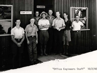
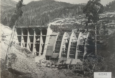
Photograph - Bogong Alpine Village 1943
The images in the Bogong Village Collection were displayed in Bogong Jack’s Tavern for over 20 years and were donated to the Falls Creek Museum when the Tavern closed in 2021. In 1939, the State Electricity Commission of Victoria established a field headquarters at Bogong to house workers and their families for the Kiewa Hydroelectric Scheme which ran from the 1930s to the 1960s. The workmen's camp was originally started with tents and was called Junction Camp. By 1947, the village supported 300 workers and their families. It included 40 houses, a hostel for single staff, a post office, a police station, a medical centre, and a primary school. The staff hostel was known as Kiewa House. At the completion of the Scheme, in the 1960s, the village was opened to public/tourism use. In 1968 the Victorian Education Department acquired the camp buildings and four houses from the State Electricity Commission of Victoria to establish an Outdoor Education Centre which operated for over 50 years. The Kiewa Hydroelectric Scheme was privatized in the 1990s and sold to Southern Hydro, before being acquired by AGL in 2005. In 2023 the Grollo Group signed a 73 year sublease on Bogong Village and has plans for its redevelopment as a workers’ village.These images are significant because they capture the development of Bogong Village as an important element of the Kiewa Hydroelectric Scheme in Victoria.A collection of seven black and white images capturing the development of Bogong Alpine Village and the Pretty Valley area during 1943.bogong alpine village, bogong high plains, bogong 1943 -
 Falls Creek Historical Society
Photograph - Bogong Alpine Village 1942
The images in the Bogong Village Collection were displayed in Bogong Jack’s Tavern for over 20 years and were donated to the Falls Creek Museum when the Tavern closed in 2021. In 1939, the State Electricity Commission of Victoria established a field headquarters at Bogong to house workers and their families for the Kiewa Hydroelectric Scheme which ran from the 1930s to the 1960s. The workmen's camp was originally started with tents and was called Junction Camp. By 1947, the village supported 300 workers and their families. It included 40 houses, a hostel for single staff, a post office, a police station, a medical centre, and a primary school. The staff hostel was known as Kiewa House. At the completion of the Scheme, in the 1960s, the village was opened to public/tourism use. In 1968 the Victorian Education Department acquired the camp buildings and four houses from the State Electricity Commission of Victoria to establish an Outdoor Education Centre which operated for over 50 years. The Kiewa Hydroelectric Scheme was privatized in the 1990s and sold to Southern Hydro, before being acquired by AGL in 2005. In 2023 the Grollo Group signed a 73 year sublease on Bogong Village and has plans for its redevelopment as a workers’ village.These images are significant because they capture the development of Bogong Village as an important element of the Kiewa Hydroelectric Scheme in Victoria.A collection of four black and white images capturing the development of Bogong Alpine Village and the Pretty Valley area during 1942.bogong alpine village, bogong high plains, bogong 1942 -
 Falls Creek Historical Society
Photograph - Bogong Alpine Village 1941
The images in the Bogong Village Collection were displayed in Bogong Jack’s Tavern for over 20 years and were donated to the Falls Creek Museum when the Tavern closed in 2021. In 1939, the State Electricity Commission of Victoria established a field headquarters at Bogong to house workers and their families for the Kiewa Hydroelectric Scheme which ran from the 1930s to the 1960s. The workmen's camp was originally started with tents and was called Junction Camp. By 1947, the village supported 300 workers and their families. It included 40 houses, a hostel for single staff, a post office, a police station, a medical centre, and a primary school. The staff hostel was known as Kiewa House. At the completion of the Scheme, in the 1960s, the village was opened to public/tourism use. In 1968 the Victorian Education Department acquired the camp buildings and four houses from the State Electricity Commission of Victoria to establish an Outdoor Education Centre which operated for over 50 years. The Kiewa Hydroelectric Scheme was privatized in the 1990s and sold to Southern Hydro, before being acquired by AGL in 2005. In 2023 the Grollo Group signed a 73 year sublease on Bogong Village and has plans for its redevelopment as a workers’ village.These images are significant because they capture the development of Bogong Village as an important element of the Kiewa Hydroelectric Scheme in Victoria.A collection of four black and white images capturing the development of Bogong Alpine Village. They depict development of the new village, the surrounding area and some staff members during 1941.bogong alpine village, bogong high plains, bogong 1941 -
 Moorabbin Air Museum
Book - Recounting training scheme development as well various personal stories, AIRCREW UNLIMITED The Commonwealth Air Training Plan during World War 2, John Golley, AIRCREW UNLIMITED The Commonwealth Air Training Plan during World War 2, 1993
Recounting training scheme development as well various personal stories, AIRCREW UNLIMITED The Commonwealth Air Training Plan during World War 2Cover jacket showing black outline drawing of pilots scrambling to aircraft, Tiger Moth in background, Harvard passing over, dark brown / blue background, white/yellow writing.non-fictionRecounting training scheme development as well various personal stories, AIRCREW UNLIMITED The Commonwealth Air Training Plan during World War 2 -
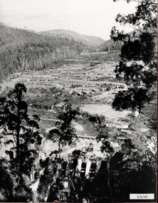
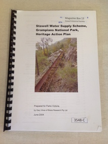 Stawell Historical Society Inc
Book, Gary Vines, Stawell Water Supply Scheme, Grampians National Park, Heritage Action Plan, 2004
White paper with black print and colour photo of a water race. this book has a black plastic bindingStawell Water Supply Scheme, Grampians National Park, Heritage Action Plan. Prepared for Parks Victoria, by Gary Vines of Biosis Research Pty Ltdstawell -
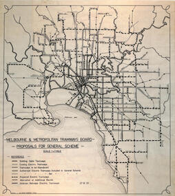 Melbourne Tram Museum
Drawing, Robert Green, Melbourne and Metropolitan Tramways Board Proposals for General Scheme, 2-1968
Drawing prepared by Robert Green for the TMSV showing the MMTB Proposals for tramway construction in the Melbourne Metropolitan Area. Traced and redrawn from the original drawing dated 27-8-1923. Shows the proposed tram lines submitted to Parliament for the report into the General Scheme as required by the MMTB Act when it was formed. See items 2088 for the original report and 2089 for a coloured print of this plan. Demonstrates the MMTB General scheme and a copy that could be used to produce further copies.Drawing - ink on mylar film.trams, tramways, mmtb, general scheme, development, parliamentk, map -
 Bacchus Marsh & District Historical Society
Map, Lerderderg Park Lands sale plan. 1911
This plan was for the sale of parcels of land from the Lerderderg Park Estate property in 1911. Advertising for the sale appeared in the Bacchus Marsh Express newspaper through July of 1911. The property was situated only a few kilometers from the township of Bacchus Marsh. The agents for the sale were L. A. Fairbairn & Co.Lerderderg Park Estate was a significant and early colonial property in the Bacchus Marsh area. This plan provides details about the first time the property was subdivided for sale. It is therefore documents an important moment in the history of this property and the broader trend of the subdivision of older and larger properties in the district.A single page paper plan showing allotments of land for sale from the Lerderderg Park property owned by John Wills. The parcels of land for sale are coloured in red.The Lerderderg River and Pyke's Creek Irigation Channel shown on the plan are in blue ink. The rest of the plan is a dark cream or beige colur with the text in black ink. The plan has been extensively annotated with hand-written notes indicating the names of people who purchased the various parcels of lands and the prices paid for those lands. Part of the top of the plan containing some text appears to be missing. The plan is pasted into a bound volume containing 76 maps or plans in total. Top: Have received instructions to Sell, account Mr John Wills, his renowned LERDERDERG PARK LANDS, so well and favourably known throughout the Commonwealth. In areas from 3 acres to 1276 acres. Every lot is either rich lucerne land (or portion now under lucerne) with some higher land adjoining Railway Station, and 2 Milk factories within 2 miles, absolutely the finest land in Victoria. Bottom: THIS IS THE FIRST SUBDIVISIONAL SALE of Rich Flats in Bacchus Marsh since the Pyke's Creek Scheme, and every lot is commanded by it. Only 32 miles from Melbourne.bacchus marsh victoria maps, land sales, lerderderg park estate, land subdivision -
 Melbourne Tram Museum
Drawing, Leonard J Flannagan, "Hawthorn Tramway Depot", 1915
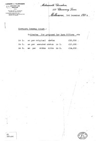
Set of 7 drawings for the development of the concept and layout of the Hawthorn Tramways Trust depot by the Architect Leonard J Flannagan, of Molesworth Chambers, 450 Chancery Lane, Melbourne. Item numbers match with the relevant image. .1 - Photocopy of a memo on the Architect's letterhead of cost estimates of three different options - dated 3/12/1914. Has a "School of Architecture" on the bottom right hand corner of the sheet and a sticker "WD GAR.4-4" giving a reference document number. Printed on an A4 sheet. .2 - Copy print of a pencil drawing - "Hawthorn Tramways Trust - Sketch Proposed Car Barn - Original Design Scheme No. 1". Reference Number in the bottom left hand corner "WD GAR.4-1". .3 - ditto showing floor plans with title "Alternative Plan No. 1" - Reference Number "WD GAR 4-6". .4 - ditto, with notes about items to be added in bottom right hand corner - Reference Number "WD GAR 4-6". .5 - as for .2 - "Amended design scheme No. 2" - Reference Number "WD GAR 4-5" .6 - Contract drawing - showing the elevation of the depot to Wallen and Power Streets - drawing No. 72, has both the names of the architect and the engineer in the bottom left hand corner. Note - amended drawing dated 6-5-15. Reference Number "WD GAR 4-5". .7 - Contract drawings - showing the first floor plan, internal elevation and the western or depot front elevation - drawing No. 71. Reference Number "WD GAR 4-7".trams, tramways, htt, hawthorn, architects, depot -
 Melbourne Tram Museum
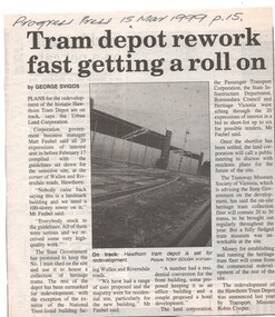
Newspaper, The Age, Progress Press, "Tram depot rework fast getting a roll on", 1999
Set of 6 newspaper cuttings about the redevelopment of the site to apartments and the Hawthorn Tram Museum Depot. .1 - Progress Press - 15/3/1999 - "Tram depot rework fast getting a roll on" - article by George Svigos, photo of depot prior to work commencing by Tony Gough. .2 - Progress Press - 19/4/1999 - "New Life for depot", about the redevelopment of the building, quotes Mike Ryan and Matt Faubel. Article by Nicole Strahan. Also "Engineer at home with the changes" - about memories of the depot by Charlie Booth - has photo of Charlie. .3 - Progress Press - 28/6/1998 - "Tram depot may be part of scheme" - about the rezoning of the tram depot. .4 - Progress Press - 19 July 1999 - "Depot developer to be announced" - quotes the Matt Faubel, lists possible developers and timeline for a decision. Article by Nicole Strahan. .5 - Progress Press - 16/8/1999 - $25m plan to convert tram site" - advised that the Urban Land Authority had selected East Asia Property Group. Article by Nicole Strahan .6 - The Age - 13/9/1999 - "Joint deal puts wheels back on tram plan" - about the redevelopment of the site, who was undertaking the work. Has a photo of Mike Ryan and Matt Faubel by the door of 180 and a photo of the depot.trams, tramways, hawthorn tram depot, tram museum, museums, minister for transport, tram 180 -
 Melbourne Tram Museum
Pamphlet, Public Transport Victoria (PTV), "Explore the world of Melbourne by Bus", 2017
Pamphlet, printed and cut for use in buses around passenger hanging rails, titled "Explore the world of Melbourne by Bus" - with an image of a bus in the PTV colour scheme with the background of various Melbourne icons or features. On the rear, advertising the "PTV App" that passengers can use to plan their journeys.trams, tramways, buses, ptv, public transport, computers -
 Melbourne Tram Museum
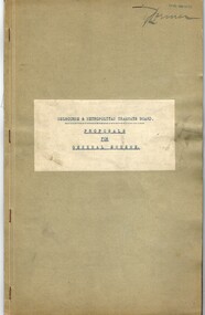
Document - Report, Melbourne & Metropolitan Tramways Board (MMTB), "Melbourne and Metropolitan Tramways Board General Scheme", late 1950's
Report - 33 pages, duplicated, stapled within a grey "Roneo Numeralpha System" folder, titled "Melbourne and Metropolitan Tramways Board General Scheme" dated 30/11/1922 giving details of the Board's proposals for tramways to serve the Melbourne metropolis, gives details of the existing system, population, proposals for extensions, special services with a sheet on statistics and an appendix listing five plans and three graphs - not with this document. See Reg Item 2088 for another copy and 2089 for Plan A referred to.Stamped on report and cover "Chief Engineer"trams, tramways, mmtb, general scheme, tramways, development, parliament, brighton, railways, finances, construction -
 Melbourne Tram Museum
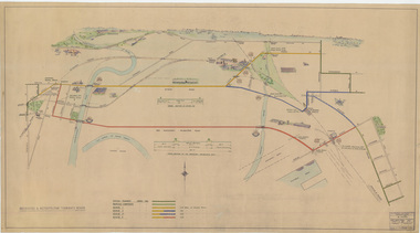
Drawing, Melbourne & Metropolitan Tramways Board (MMTB), "Footscray - City Tram Schemes - Perspective Overview", Dec. 1947
Drawing - hand coloured - not formally titled - "Footscray - City Tram Schemes - Perspective Overview", shows existing tramways, proposed conversions, four different schemes or proposals and the length of double track. Shows roads, bridges, railway lines, docks, industry location, road cross sections and other planning features. Dated 4-12-1947, drawing No. P10868. Note pdf version of this drawing on the images file, but will not open with dbtext works pdf viewer. Converted to a jpg which does open.On left hand edge on the rear has in pencil - "Footscray - City Tram Schemes - Perspective Overview" P10868 1947 Spare (dup)trams, tramways, footscray, new tramway, north melbourne, spencer st, victoria st, bridges -
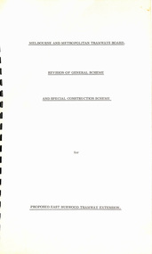 Melbourne Tram Museum
Document - Report, "Revision of General Scheme and Special Construction Scheme for Proposed East Burwood Tramway Extension", 1974
Report - Foolscap bound with black comb binder, 10 pages + two fold out drawings + card covers titled "Revision of General Scheme and Special Construction Scheme for Proposed East Burwood Tramway Extension", not formally dated (1974). Continuing information on the proposal such as route, existing services bus and rail, General Scheme, type of track construction, overhead, costs, fares, resumptions, plans. Includes plans P14604 (shows track arrangement) P14605 general location including the City of Melbourne.trams, tramways, east burwood, new tramways, general scheme, construction -
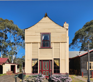 Old Gippstown
Building - Loren Iron House
... , Latrobe City Planning Scheme. It is also listed on the Register ...'Loren' (formerly James Hogg's house) is a two-storey gabled prefabricated house, constructed using broad-gauge corrugated iron and was originally erected at 60-62 Curzon Street, North Melbourne in 1853 for builder, James Hogg. By 1968 the building had deteriorated and it was dismantled and moved to Old Gippstown where it was re-erected and restored. The building's external framing system consists of exposed metal columns with Gothic panel motifs at the corners. Internally the timber framed walls have been finished with new papers over new Hessian. The corrugated iron roof has an unusual concave form and the windows, floors and doors are of moulded softwood. State historic significance as a rare type of iron prefab. house. Listed on the Victorian Heritage Register and covered by a Heritage Overlay, Latrobe City Planning Scheme. It is also listed on the Register of the National Estate.Tall square-shaped two-storey corrugated iron building with a curved corrugated iron roof with two outside brick chimneys. prefabricated iron houses, old gippstown, west gippsland, gippsland, gippsland heritage park, goldfields, coal mine, victorian era, moe, historical village, city of melbourne, north melbourne, curzon street, james hogg, prefabricated house, two-storey gabled prefabricated house, old gippstown heritage park, latrobe valley, loren, latrobe city council