Showing 5882 items
matching residential
-
 Ringwood and District Historical Society
Newspaper, Scrapbook Clipping, Library Collection, Ringwood, Victoria
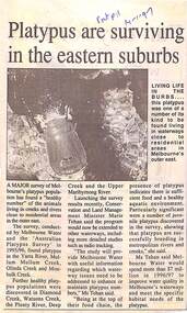
Newspaper Clipping from "The Post", 14 January 1997, Page 11, "Platypus are surviving in the eastern suburbs"'.A major survey of Melbourne's platypus population has found a "healthy number" of the animals living in creeks and rivers close to residential area in the outer east. Conservation and Land Management Minister, Marie Tehan, was present at the launching of the survey results, and spoke in detail about the results and the future planning and financial aid for the health of the Melbourne waterways. -
 Ringwood and District Historical Society
Contracts, Acquisition of the land in Grey Street and Ware Crescent, Ringwood East by the Graduates Assoc. of the Kindergarten Training College, Melbourne. 1950-1960, 1950-1960
Various papers from the titles Office, City of Ringwood Solicitors for accounts on the purchase of the land by the Graduates of the Kindergarten Training College and caveats pertaining to the land. This was the site of the Warrawong day and residential care kindergarten which was demolished c.2000 to be divided into housing blocks.18 pages of documents relating to the acquisition of the land in Grey Street and Ware Crescent, Ringwood East by the Graduates Assoc. of the Kindergarten Training College, Melbourne. -
 St Kilda Historical Society
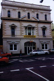
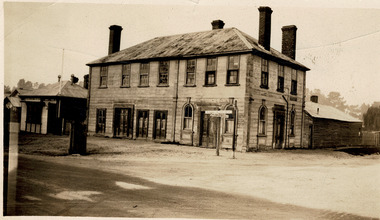
Photograph, St Kilda Coffee Palace
A coffee palace was a residential hotel that did not serve alcohol. Most were built in the late 19th century in response to the temperance movement and were popular with families. St Kilda Coffee Palace was built in 1870s and operated until 1888. Currently a Backpackers Hostel.Colour photographst kilda, grey street, st kilda coffee palace, coffee palace backpackers -
 Greensborough Historical Society
Booklet - Report, RBA Architects, Uglow House (Wyldefell), 2021
Constructed in 1955-56, the house was designed by Robin Boyd for Dr Arthur G R Uglow and his wife Enid, one of the buildings that formed a surge in residential occupation of the semi-rural Montmorency area in the 1950s. Citation 21 of the Banyule Heritage Study 2020.13 p. typescript and colour photographs, stapledbuena vista drive montmorency, uglow family, robin boyd, banyule heritage study 2020, montmorency - places -
 City of Moorabbin Historical Society (Operating the Box Cottage Museum)
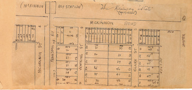
Plan - McKinnon Railway Estate, McKinnon, c 1921
At the end of World War One, there was a renewed interest in residential land and a number of estates opened up in the Municipality of Moorabbin. The train line from the city to Frankston was electrified in 1922 which intensified the sale in the municipality of Moorabbin, particularly land which was in the vicinity of the railway stations.Example of the progress of the Municipality of MoorabbinHand drawn plan of the McKinnon Railway Estate, McKinnonMcKinnon Railway Estate, McKinnon - hand drawn planmckinnon road, watkins street (now bent street), claire street, real estate, mckinnon, moorabbin -
 Hume City Civic Collection
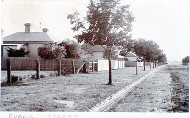
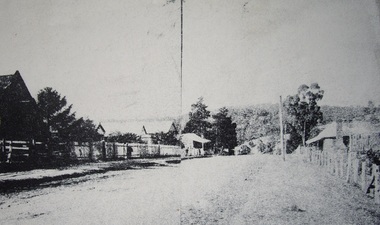
Photograph - Evans Street, Sunbury, c1880 - 1900s
The photograph shows a picture of Evans Street Sunbury taken from the T intersection at Macedon Street and looking south. When the photograph was taken it was one of Sunbury's main residential areas. Since the 1980s the houses in the image have been demolished and replaced with commercial development.- Over the years Evans Street has undergone much change from being a residential strip to being the main commercial hub in Sunbury.– An enlarged photograph of a streetscape with a row of trees growing along the footpath and a number of weatherboard Victorian style double fronted cottages. Both the roadway and footpath are not surfaced and the gutter is lined with stone pavers.sunbury -
 Sunbury Family History and Heritage Society Inc.
Photograph - Evans Street, Sunbury, c1900s
The photograph shows a picture of Evans Street Sunbury taken from the T intersection at Macedon Street and looking south. When the photograph was taken it was one of Sunbury's main residential areas. Since the 1980s the houses in the image have been demolished and replaced with commercial development. Over the years Evans Street has undergone much change from being a residential strip to being the main commercial hub in Sunbury.A sepia photograph with a white border across the bottom and in post card format of a streetscape with a row of trees growing along the footpath and a number of weatherboard Victorian style double fronted cottages. Both the roadway and footpath are not surfaced and the gutter is lined with stone pavers.EVANS STREETevans street -
 Beaufort Historical Society
Beaufort Buildings, Lighthouse
The lighthouse was moved from corner High and Neil Streets to the corner of Lawrence and Neil Streets in 1882 to be the new premises of Dr Johnston. It was later Glovers Boarding House. It was demolished in 1933, replaced later by Elders Stock Agents. It is now the site of 2 residential units.Impressive early buildingbeaufort, beaufort buildings, dr johnston -
 Ringwood and District Historical Society
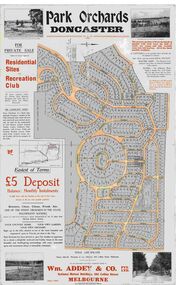
Map, Park Orchards Land Sale Advertisement, Doncaster, Victoria, Circa 1926
Large linen backed map of the Park Orchards subdivision for private sale of residential sites and recreation club, highlighting local facilities, services and layout of the estate. Surveyors - Tuxen & Miller, 34 Queen Street, Melbourne. Agents - Wm Addey & Co., Pty Ltd., National Mutual Buildings, 395 Collins Street, Melbourne, Phone F3906. Terms £5 deposit balance monthly installments of £1 with the residue at the end of five years. Subdivision includes Alva Avenue, Arundel Road, Aviemore Avenue, Berringa Road, Bowmore Avenue, Brucedale Crescent, Brympton Avenue, Camber Avenue, Cawdor Avenue, Colin Avenue, Corriedale Crescent, Craithie Avenue, Daintree Avenue, Dalry Avenue, Dirlton Crescent, Drayton Crescent, Elgin Crescent, Enfield Avenue, Ennismore Crescent, Euston Avenue, Feversham Avenue, Frogmore Crescent, Gosford Crescent, Granard Avenue, Hopetoun Road, Hylton Avenue (later Knees Road), Jura Avenue, Park Road. -
 Melbourne Tram Museum
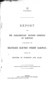
Document - Report, Victorian Parliament, "Report - The Parliamentary Standing Committee re the Beaumaris Electric Street Railway.", Dec. 1916
Printed - 6 page foolscap, stapled on left hand side, 2 sections, Victorian State Parliamentary Report titled "Report - The Parliamentary Standing Committee on Railways on the question of the Beaumaris Electric Street Railway." - dated 22 December 1916. References previous reports, Black Rock, Beaumaris, residential development, routes and costs of the proposed tramway, costs provided by the Chief Engineer for Railway Construction, E. Kernot, and Committee recommendations - tempered by the War.trams, tramways, sandringham, black rock, beaumaris, railways, tramways, proposals -
 Eltham District Historical Society Inc
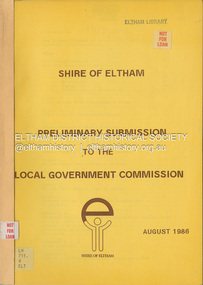
Document, Shire of Eltham, Shire of Eltham Preliminary submission to the Local Government Commission, August 1986
Report produced by the Shire of Eltham in August 1986 as a prelimary response to proposed municipal restructure in the state of Victorianon-fictionReport produced by the Shire of Eltham in August 1986 as a prelimary response to proposed municipal restructure in the state of Victoriacouncil amalgamation, annexation, rates -
 Greensborough Historical Society
Photograph - Digital image, Main Street Greensborough, 1902
Early view of Main Street Greensborough showing the mainly residential nature of the buildings. Photographs from the collection of Peter Blackbourn, a descendant of the Chapman Stock family. Annotations to photos by Peter Blackbourn. Photo and article appeared in The Diamond Valley News 9/10/1984 page 29.Digital copy of black and white photograph.peter blackbourn, main street greensborough -
 Newman College, University of Melbourne
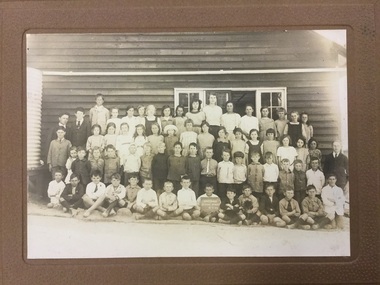
Photograph, Yallourn School No. 4085 8.2.23
This photograph was found in the archive of Newman College, a residential college at the University of Melbourne. It is not currently clear what the connection is between Newman College and the Yallourn School. Was one of the teachers at the school a former resident of Newman? Or did a student from the school come to Newman later in life, bringing this photograph? The town of Yallourn in the La Trobe Valley Victoria no longer exists except in photographs, records and memories. The town was established by the State Electricity Commission from the 1920s to the 1950s and was removed in the 1980s to make way for coal mining.Black and white photograph pasted onto brown mount board. The image shows children in four rows and their teachers in front of their weatherboard school building. Three rows of children are standing, the front row is seated and the middle child in the front row holds a sign saying Yallourn School No. 4085 23.2.23yallourn, yallourn school, newman college -
 Vision Australia
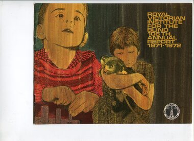
Administrative record - Text, Royal Victorian Institute for the Blind annual report 106th 1971-1972, 1970-1971
Articles in the annual report include: Matron Dunnell receiving a Churchill Fellowship, a second year wrap up of residential accommodation for children with multiple disabilities, replacing cassette players with newer models, employment of 120 people in the factory and 82 people received individualised training and rehabilitation programs.1 printed volume with photographsroyal victorian institute for the blind, annual reports -
 Melbourne Tram Museum
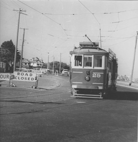
Photograph - VR 29 Baths Terminus, Jim Seletto, circa January 1958
The photograph shows VR tram No.29 with the destination St Kilda Rly near the Middle Brighton crossover. Road work signs indicate road closure and detours. In the background track excavation may be underway. The beach front and residential housing are also visible. Photo by J Seletto.Yields information about the last VR tramway and its progressive closure.Black and White photograph with photographer's notes on rearIn red biro on rear: 'VR Dreadailnought [sic] 29 baths Terminus Jan 58? D Print, JSE8'trams, middle brighton, vr trams, tram 29, closure -
 International House, The University of Melbourne
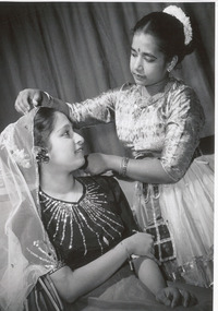
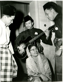
Photograph (Item), Rajeswary Thambiah and Lalita Rajasooria, University of Melbourne students from Malaysia, preparing for 'Oriental Rendezvous', a performance hosted by International House, 1957
In 1957, its first year as an active residential college, International House hosted a drama presentation called 'Oriental Rendezvous'. Domestic and international students from the University of Melbourne presented cultural performances, including Rajeswary Thambiah, a science student, and Lalita Rajasooria, an arts student, both of Malaysia.performing arts, fundraising -
 Bendigo Historical Society Inc.
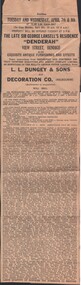
Newspaper - NOTICE OF AUCTION - 'DENDERAH' VIEW STREET, BENDIGO
Newspaper Cutting. Announcement of auction of 'Denderah', the property in View St. Bendigo of Sir George Victor Lansell. Plus contents of antique furnishings and effects - all items listed. Auctioneers L.L. Dungey & Sons in conjunction with Decoration Co. of Melbourne. Auction dates Tuesday and Wednesday, 7th and 8th April. Year unknown. George Lansell died 6.1.1959. Wife pre deceased him. Auction was probably in 1959.buildings, residential, auction, auction notice, denderah, george victor lansell, l.l.dungey & sons, decoration co. -
 Ballarat Heritage Services
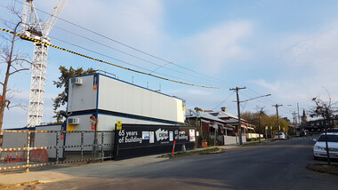
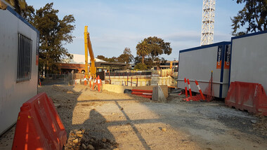
Digital photograph, Lisa Gervasoni, Derby Street redevelopment, 2017
building, derby street, kew, residential, apratment, construction, redevelopment, overdevelopment -
 Ballarat Heritage Services
Digital photograph, Lisa Gervasoni, Derby Street Redevelopment, 2017, 2017
Colour photograph of a block of land being redeveloped in Kew, Victoriabuilding, derby street, kew, residential, apratment, construction, redevelopment, overdevelopment -
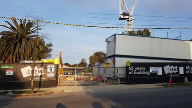 Ballarat Heritage Services
Digital photograph, Lisa Gervasoni, Derby Street redevelopment, 2017
building, derby street, kew, residential, apratment, construction, redevelopment, overdevelopment -
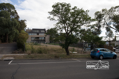 Eltham District Historical Society Inc
Photograph, Peter Pidgeon, 22 Luck Street, Eltham, 11 February 2018, 11/2/2018
Development application 252/2017/03P: Use and development of the land for 8 three storey townhouses (revised to 7) Land sold 20 Dec 2107 for $1,515,000 - https://www.realestate.com.au/sold/property-residential+land-vic-eltham-201972410 Previously $140,000 June 1994 and $165,500 Oct 1988 Born digital image (6)eltham, luck street, streets, houses -
 Kiewa Valley Historical Society
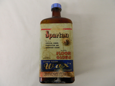
Bottle - Liquid Wax, mid 1900's
This bottle of liquid floor polish was manufactured before 1960(taken over by Wattyl) in a period when most of the floors in high traffic areas were covered in linoleum. Most of the floors using this product during this period would have been kitchens and laundries. During this period the cleanliness of the kitchen, hallways and eateries had to appear clean (cleanliness was a sign of a bacteria free area). This was a priority for kitchens, mess areas(SEC Hydro Scheme facilities) and connecting walkways. The cleanliness attitude was enhanced in the rural areas due to the "dirty" farm work not impinging upon the residential home.When Mount Beauty was first inhabited all the residential and worker's facilities were a prime area for linoleum floor surfaces. The liquid floor polish was in great demand, "a polished floor is a clean floor".This bottle of liquid floor polish is very significant to the Kiewa Valley, not only that it covers the floors of every home and residential barracks of the first major development of a "town" now known as Mount Beauty but also it demonstrates that the "cleanliness" approach of early Australians living areas in the rural regions was "on par" with its city cousins. It is the smaller types of mores that underlie the "mushrooming" cultural and psyche "wholeness" of an ever expanding Australian culture.This brown opaque glass bottle with an oblong shape has a blue coloured "screw on" cap. It has a "wrap around" label glued firmly on the bottle and covers the front and sides.On the front main label under a red line, "SPARTAN" underneath in smaller print "For use on" below this, "LINOLEUM, RUBBER, COMPOSITION AND HARDWOOD FLOORS" besides this is an encircled Trade Mark of a "Spartan Warrior holding a spear and shield" these word follow the curviture of the circle and are below it "TRADE MARK REGISTERED" Below this are "SUPER FLOOR GLOSS" to the left in very small print "Nett Contents 16 Fluid Ounces". Below this on a blue background and in white print"LIQUID FLOOR WAX WATER REPELLENT". On the bottom of the label "Made under licence by HARDIE TRADING LIMITED for SPARTAN PAINTS PTY, LIMITED" below this in small print "Melbourne, Sydney, Adelaide, Brisbane, Perth, Hobart, Launceston, Geelong. Embossed on the bootm of the glass is" G/Mfloor cleaners, liquid polish, "hygienic" clean floors. -
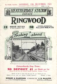 Ringwood and District Historical Society
Flyer, Subdivisional Land Auction Sale Brochures, Heatherdale Station Estate, Ringwood, Vic. - 1923 and 1924
Two double sided multi-folded pages advertising public auction sales of shop sites and residential allotments on Saturday, 15th December, 1923 and Saturday, 2nd February, 1924, including summary of local facilities, services and map showing layout of the estate. Includes a photograph depicting proposed site for first Heatherdale railway station and a panoramic view of Ringwood from the railway level crossing in Heatherdale Road. 1923 and 1924 flyers are identical except for the auction dates printed at the top.Subdivision includes Heatherdale Road, Molan Street, Yallourn Parade, Newman Street, and Madden Street. Agents - Knight & Harwood, 315 Collins Street, Melbourne, Phone 10615, 10616 Central, in conjunction with J.B. McAlpin, Opposite Railway Station, Ringwood. Phone Ringwood 7. -
 Kiewa Valley Historical Society
Relay Protection Instrument, Circa 1950's
This protection relay apparatus (a large electrical fuse), which permits the easy monitoring and disconnection of faulty electrical apparatus connected to the large SEC Victoria Hydro Scheme's electrical power producing generators. These generators are powered by the hydro force of "stored" water at a higher altitude. The establishment of both the NSW and Victorian Hydro Schemes was achieved from the early 1900's to the 1960's. At this point in time the need for additional power sources to quench both an industrial and domestic demand for electricity was purely an economic and not and environmental (carbon reduction) factor. This hydro scheme was instigated by "the Government of the day" as a bold move and was the major force of the World War II refugee and "technical" workforce inclusion of skilled and unskilled migration into the Australian environment. Although this mass "invasion" of workers with families was thought of in some circles as intrusive, the expansion of population post war years and its integration into the Australian rural sector, produced the multi- lingual multi-cultural diversity of later years.This protection relay is very significant to the Kiewa Valley as its use was introduced during the Kiewa Hydro Scheme. Although only a small apparatus it was part of the explosion of human resources into the valley. This influx of population transformed the region from that of a basically quiet rural region to one which evolved into both an industrial and a larger residential community. This evolution in the valley created a change, not only in the "physical" landscape but also the socio-economic expansion which permitted other "tourist" based industries into the valley.This protection relay unit has a black painted metal shell with four copper enclosed "prongs" fastened to the rear of the housing(from a bake-lite plate) . Between these "prongs" are four "empty" points allowing additional "screw on" bases. The front glass enclosed meter and recorder allows for the identification and automatic disconnection of any faulty equipment connected to the main power generator. This equipment acts similarly to a modern day circuit breaker found on the electrical circuit boards of residential homes.On the top section of the front panel "ASEA" to the left "Made in Sweden" and to the right "Frabrique en Suede" below this "RIS" below this a graph and next to it two columns of numbers and a pointer for each setkiewa hydro electricity scheme, victorian state electricity commission, relays, generators -
 Ringwood and District Historical Society
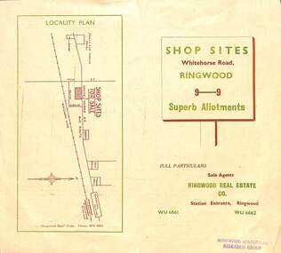
Flyer, Ringwood Mail, Retail Subdivision Brochure - Plan of New Shop Sites, Ringwood, Victoria. - circa 1950
Double sided folded page advertising shop sites in Whitehorse Road, Ringwood, with locality plan, price list, terms of sale, summary of local facilities and services, and diagram showing layout of 9 retail allotments for sale. These sites were originally zoned as residential as part of the 1926 "Olive Grove Estate" subdivision. (See Vicorian Collections Reference 5169). The 9 new shops were later allocated street numbers 58 to 64 Whitehorse Road, Ringwood.Locality plan showing shop sites for sale on Whitehorse Road, Ringwood, between New Street and Olive Grove. Sole Agents: Ringwood Real Estate Co., Station Entrance, Ringwood, (Telephone) WU6661, WU6662. -
 Bendigo Historical Society Inc.
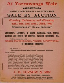
Document - IAN DYETT COLLECTION: AUCTION CATALOGUE - YARRAWONGA WEIR
Two beige coloured auction catalogues with red and black printing for a sale on the 20th, 21st and 22nd June 1939. For sale were Contractors, Engineers & Mining Machinery, Plant, Stores, Buildings and Houses for Removal, Valuable Equipment, etc and 11 Residential Properties By Order of the State Rivers and Water Supply Commission, Melbourne. H. Curnow & Son in conjunction with Green, Manning & Co, Agents, Yarrawonga were the auctioneers. Contains some information about the Yarrawonga Weir and a black and white photo of the bank.business, auctioneers, j h curnow & son pty ltd, ian dyett collection - auction catalogue - yarrawonga weir, green manning & co, the state rivers and water supply commission, j h curnow & son, j l jamieson, messrs a challingsworth pty ltd, jaques bros, austral otis eng co, mr e d shaw, r g knight, h h c williams, f a nevill, the cambridge press -
 Eltham District Historical Society Inc
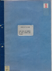
Document - Folder, Shire of Eltham, Land uses by number of lots, street and riding, 1984
In work undertaken by the Shire of Eltham in revising its residential multi-unit development policy, information was collated by street and number of units. The exercise was expanded to include other land uses. At the end of each Riding is given a summary of the number of the various major land uses and index to abbreviations used on the last page11 pages inside blue coverharry gilham collection, land use, streets, ridings, dwellings, units -
 Kiewa Valley Historical Society
Photograph Junction Dam, Photo Junction Dam and Bogong Village in Background, circa 1950s
This item clearly shows the conditions covering both working conditions and housing in the construction of the Junction Dam in the 1940s. Working conditions were extreme and health and safety legislation was at its infancy. The residential buildings were intended to last only for the period of construction, however greater demand for longevity as a tourist haven prevailedThis photo of the construction of the Junction Dam, with The Bogong village as backdrop, details the harsh conditions faced by construction workers, building dams and villages to accommodate workers in the 1940s to the 1950s. Australia at this period in time, experienced a surge of population (influx of World War II refugees), which was the catalyst for developing and undergoing an enormous hydroelectricity program for the Alpine regions, both in Victoria and New South Wales. This program was initiated to supply electricity to the major southern Australian cities of Adelaide, Melbourne and Sydney. It was thought that these developments would reduce, if not eliminate, the requirement for coal driven power stations. However time has demonstrated that these power stations have not matched the demand required by the industries and the populations of the major urban and cities.Black and white photo of original photo with a flashlight reflection in the bottom centre. The photo is on Kodak XtraLife II paper. The paper is semi gloss.This photo is of the construction of the Junction Dam Wall with the Bogong Townshiip in the background.Back of photo is printed " Kodak XtraLite II paperdam construction, bogong village, alpine development, junction dam -
 International House, The University of Melbourne
Photograph (Item), Neil Murray, Mohamed Shah bin Hussan, Isa Ahmad, Zubaidah Mohd Said, and Abang Bohari, performers in Oriental Rendezvous, a performance hosted by International House, 1957
In 1957, its first year as an active residential college, International House hosted a drama presentation called 'Oriental Rendezvous'. Domestic and international students from the University of Melbourne presented cultural performances, including Mohamed Shah bin Hussan, Isa Ahmad, Zubaidah Mohd Said, and Abang Bohari, all of Malaysia.performing arts, fundraising -
 Kew Historical Society Inc
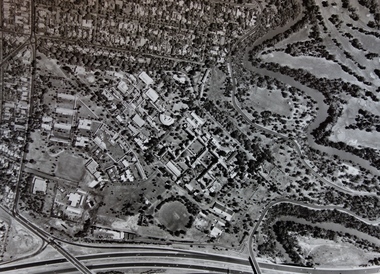
Photograph - Aerial Photograph, Aerial Photograph of Willsmere, circa 1980, c. 1980
This aerial photograph shows the Kew Cottages, and doctors/clergy residences on the north side of Wills Street, before the State Government sold the land for residential development. The doctors residences in Wills street were made of 'Glen Iris' Olympic Bricks. According to neighbours of the time most of the buildings were demolished overnight in the 1980s.Aerial photograph of Willsmere and the Kew Cottages bounded by the Boulevard, the Chandler Highway, Princess Street and Fellows Street. The roundabout at the intersection of Princess Street, Wills Street, and Eglinton Street is at the top left. The Eastern Freeway is at the lower edge of the photograph.kew cottages, eastern freeway, willsmere, yarra river, aerial photographs -- kew (vic), kew boulevard, willsmere mental hospital, kew mental hospital, kew childrens cottages