Showing 870 items
matching road traffic
-
 Surrey Hills Historical Society Collection
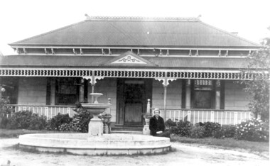
Photo, 'Spenceycroft', Canterbury Road
... The photo is of ‘Spenceycroft’ at 654 Canterbury Road... Road Canterbury melbourne The photo is of ‘Spenceycroft’ at 654 ...The photo is of ‘Spenceycroft’ at 654 Canterbury Road, Surrey Hills. For many years this home was hidden behind a large fence sheltering it from the noise of traffic along Canterbury Road, however it dates back to the very early days of settlement in the Surrey Hills area. Canterbury Road was then known as Delany’s Road. ‘Spenceycroft’ is thought to incorporate part of the original farmhouse built on the site by George Klepper, who planted a vineyard in the area. George’s family was one of a number of German families who settled in Surrey Hills during the later part of the 19th century. Later, the land associated with ‘Spenceycroft’ was worked as a dairy farm by James and Elizabeth Rayment. In recent years 'Spenceycroft' has been sold several times and has become increasingly derelict. Sold again in 2015 when it had become quite derelict, it was demolished and re-developed.A black & white photo of double-fronted Victorian style home with a fountain centre front and low foliage in front of the veranda. A woman is sitting by the fountain. 'spenceycroft', canterbury road, james rayment, elizabeth rayment, george klepper -
 Surrey Hills Historical Society Collection
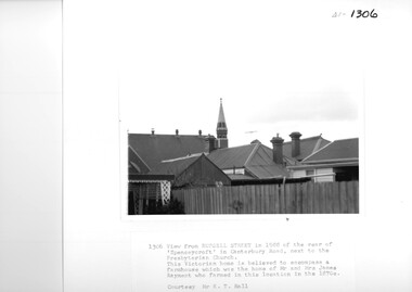
Photograph, View from Russell Street, of the rear 'Spencecroft' in 1988
... sheltering it from the noise of traffic along Canterbury Road. It has... sheltering it from the noise of traffic along Canterbury Road. It has ...Spenceycroft was home of James and Elizabeth Rayment, who had a dairy farm in the area in the 1870s. The house was located in Canterbury Road next to the Surrey Hills Presbyterian Church. For many years, it was hidden behind a large fence sheltering it from the noise of traffic along Canterbury Road. It has been claimed that it incorporated part of the original farmhouse built on the site by George Klepper, who planted a vineyard in the area. George’s family was one of a number of German families who settled in Surrey Hills during the later part of the 19th century. In recent years Spenceycroft was sold several times and became increasingly derelict. Since its last sale, it has been demolished. Some of the above may be in error. Research is currently being undertaken to authenticate claims previously asserted.A black and white photograph of the rear of some buildings from Russell Street, at the rear of 'Spencecroft'.house names, spenceycroft, spencecroft, russell street, surrey hills, james rayment, (mrs) elizabeth rayment -
 Surrey Hills Historical Society Collection
Photograph, D716 steam train at Mont Albert Station, 1919, 1919
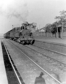
The photo was taken at 8.15am on Friday 12 September 1919. The D class was a passenger and mixed traffic steam locomotive which operated on the Victorian Railways from 1902 to 1974. Originally it was introduced on mainline express passenger services, but they were quickly superseded by the much larger A2 class and were relegated to secondary and branch line passenger and goods service, where they continued in service for the next fifty years. The D716 was probably built at the Newport Workshops, post 1910 and before 1914. The expansion of Melbourne's population into new suburbs early in the 20th century, and the delay of the suburban electrification project, meant there was the need for faster and more powerful steam locomotives for the suburban rail network. In 1908, the basic design was adapted to create a more powerful locomotive. They were put to work on longer and hillier suburban routes including the Lilydale line. A total of 58 were built between 1908 and 1913. See wikipedia for a more detailed history of the D class locomotives. Electric trains replaced steam in 1922. Mr William Holmes of 'Lugano', Mont Albert Road was in charge of the design and introduction of the electrification of the Melbourne rail system.Black and white photo of a steam train approaching the platform at Mont Albert station. Rear in blue biro in Jocelyn Hall's handwriting: "Hamilton St Mont Albert / probably 1919".mont albert station, railways, trains, d class locomotives, norman carter, steam trains -
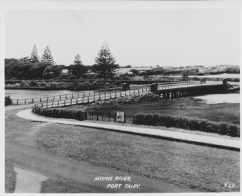
 Port Fairy Historical Society Museum and Archives
Photograph - Photograph,copy
Port Fairy Moyne river bridgeBlack and white photograph of Moyne river traffic bridgebridge, moyne river, low tide, griffith street -
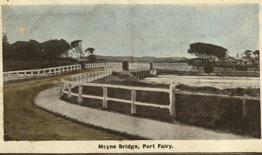
 Port Fairy Historical Society Museum and Archives
Postcard, Moyne River Port Fairy
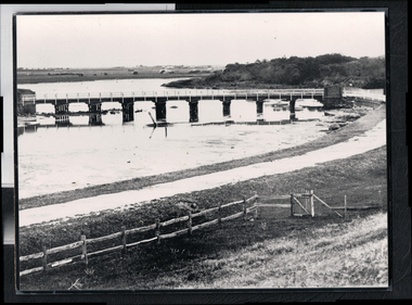
This bridge was built in 1902, replacing a previous structure that crossed the Moyne River from 1857 and linked Belfast with Belfast East, as the two areas of Port Fairy were then known. Prior to that, passage over the river was via a ford (an underwater stone track that allowed wagons to cross when the river was low) located just north of where the current car bridge stands. The present bridge survived the great flood of 1946, but has been the subject of innumerable patch-up jobs over its 114 years. In 2012, the bridge underwent a detailed structural assessment and was given the OK for the next eight to 10 years, notwithstanding the need for regular maintenance works. At the time, it was estimated a new bridge would cost between $2-3 million. It was extensively refurbished in 2016Sole means for traffic to cross to the east side of Port FairyBlack and white photographMoyne River Port Fairyriver, moyne, bridge, road -
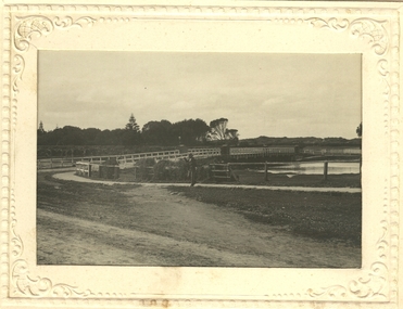
 Port Fairy Historical Society Museum and Archives
Photograph
Moyne Bridge & Gardens 1904/06Black and white Photograph glued to cardboard Bridge and Gardens Port Fairy R. Scott photomoyne bridge, gardens, traffic, griffith street -
 Port Fairy Historical Society Museum and Archives
Photograph
Moyne BridgeBlack and white photograph in an embossed card frame of the West side of the traffic bridge over the Moyne river Postcardmoyne bridge, gipps street, traffic, moyne river -
 Port Fairy Historical Society Museum and Archives
Photograph - Postcard, Moyne bridge
Photograph hand tinted of the Moyne river road bridge taken from Gipps Street showing house on the far bank on the right side taken for use as a PostcardMoyne Bridgemoyne bridge 1910, moyne river, traffic, gipps street -
 Port Fairy Historical Society Museum and Archives
Photograph
Moyne river bridge photograph taken in 1956 showing Blakes caravan park in backgroundColoured landscape of the Moyne River bridge taken from the balcony of the house (Riverside) on the corner of Regent Street and Gipps street From Tom Bartlett's Gipps Street looking East over bridge 1956bridge, moyne river, traffic, gipps street -
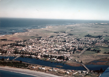 Port Fairy Historical Society Museum and Archives
Photograph
Aerial-Port Fairy 1972Coloured aerial photograph aerial, moyne river, douglas house, railway, water tower, traffic bridge, pedestrian bridge -
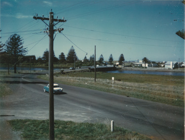
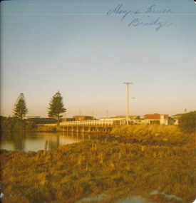 Port Fairy Historical Society Museum and Archives
Photograph
Moyne River Bridge 1970's North sideColoured photograph of Moyne river traffic bridge taken from the North side on the West bankMoyne River Bridge- on frontmoyne river, bridge, west side -
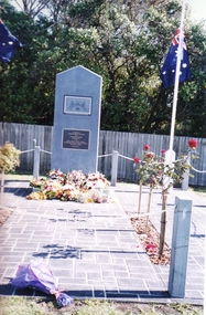 Port Fairy Historical Society Museum and Archives
Photograph
This Soldiers Memorial was erected in the centre of the town as the original Memorial stands at the top of the hill on the busy Princes Highway. This made the site difficult to police and march to because of the traffic passing through the town.Coloured photograph of Soldier’s memorial with flowers during Anzac Daymemorial, bank street, railway place, soldier -
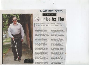 Vision Australia
Article - Text, Guide to life
Neil Maxwell talks about his canes, how they are used, how he refused to get one earlier in life and the consequences (ie: a traffic accident) for not doing so. Published in the Progress Press, October 18, 1999.Colour photograph with article on Neil Maxwell and his canenon-fictionneil maxwell, elizabeth maxwell, orientation and mobility -
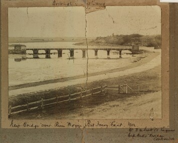 Port Fairy Historical Society Museum and Archives
Photograph, New Bridge over River Moyne Port Fairy East 1902
New Bridge over River Moyne Port Fairy East 1902Black and white photograph view of new bridge over the river Moyne taken in 1902New Bridge over River Moyne Port Fairy East 1902 (handwritten) Mr G.W.Scott C.E.Engineer. .......Watts Riordan Contractorsbridge, river, moyne, river moyne, traffic -
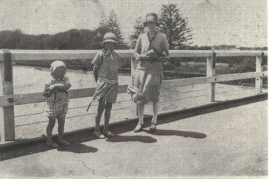 Port Fairy Historical Society Museum and Archives
Photograph
Family standing on Moyne River bridgeBlack and white family photograph bridge, moyne river, famiily, children, mother, traffic, car -
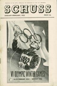 Falls Creek Historical Society
Journal - Schuss Vol. 18. No. 1 January - February 1952
Schuss was advertised as Victoria’s Official Ski Journal It was issued monthly from 1935 to 1961 except during the war when summer issues covered two months. This continued after the war, but it averaged 10 issues annually over its 25 year life. Schuss was published by the Ski Club of Victoria which had a membership of 38 Ski Clubs and demanded to be recognised as the prime authority on skiing in the state. The other 30 ski clubs with 85% of the members disagreed and the politics of skiing became heated. These clubs formed the Federation of Victorian Ski Clubs with their own journal, Ski Horizon. With the establishment of the Victorian Ski Association, Ski-Horizon published its last issue in Nov - Dec. 1955 and the role of the official journal was fully taken over by “Schuss”. This item is significant because it contains stories, images and information documenting the development of the ski industry in Victoria.The journal features stories and events chronicling developments in Victoria and internationally. Items related to the Falls Creek Area in this issue include:- Cover - Image acknowledging the Australian team in the Oslo Winter Olympics Page 31 - TRANSPORT TO FALLS CREEK - Following press reports in recent months regarding curtailment of the work of the State Electricity Commission on Bogong High Plains, there will be no snow clearing on the road above Howman's Gap next winter, and possibly no snow clearing at all. Traffic will not be permitted to proceed where no clearing is being carried out. Apart from this, it is hoped that it will not be necessary to curtail any further the general arrangements in force last winter. During this summer the road will be closed to visitors generally, but arrangements will be made for working parties at ski huts to proceed to or from Falls Creek between 8 a.m. and 5 p.m. on Saturdays and Sundays only, provided that prior arrangements have been made.winter olympics 1952, road access to falls creek 1952 -
Canterbury History Group
Document - Canterbury. Provision of Railway Bridge - Up Line, Office of Chief Traffic Manager, 9/09/1968 12:00:00 AM
Notification from Victorian Railways of the new railway bridge being opened for the Up Line service on Sunday 15 September 1968canterbury, canterbury station, canterbury road, victorian railways, railway bridges, railway lines, trains -
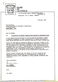 Wonga Park Community Cottage History Group
Work on paper (Item) - Letter, Wonga Park 1984 Letter from Shire of Lillydale to Wonga Park & District Residents' Association with four alternative intersection treatments
The Wonga Park and District Residents' Association requested the Shire of Lillydale consider removing the crests on Jumping Creek Road Wonga Park east and west of the intersection with Yarra and Dudley Roads to improve visibility at the intersection. The Shire of Lillydale thought that this would simply increase the speed of traffic through the intersection and suggested a roundabout be built and came up with four alternative treatments. When they discovered that a roundabout would require water mains to be lowered and the M&MBW would not give a quote on the cost (which would be substantial) they opted for traffic islands instead. -
 Melton City Libraries
Photograph, Wendy Barrie, Unknown
Eldest daughter of Edna and Bon Barrie, born on 03 November 1943 in Melbourne, Victoria, Memoirs of Wendy Barrie, recalling the early formative years of life in Melton: In 1949 I started school at Melton State School no 430 and was driven the 2½ miles to there by my parents at first. Later we walked home in the afternoons or were picked up by car as we made our way home along the Western Highway. In 1956 I went to Bacchus Marsh High School. There were 4 students in grade 6 and 3 of us went to the High School. The students from Melton, Melton South and Toolern Vale State Schools went by bus to Bacchus Marsh High School as far a fifth form. My parents drove me to the pick up point and during the five years of travel to High School. The bus travelled via Toolern Vale and later went through Exford and through Parwan. On the return journey in the afternoon the bus went in the reverse direction. The bridge at Exford was an old narrow wooden one, and the students had to get off the bus and walk across, with the driver crossing in the empty bus for safety reasons. There was a travelling allowance paid to parents and it was estimated from the distance the crow flies, a straight line. We lived a Ferris Lane, just where the Harness Racing entrance is now situated about 2 ½ miles by road to school too close to qualify for the subsidy. While at State School Melton we would walk home in a group with the Nixon and Gillespie children, along the main road over the bridge near the Shire Offices and down a hill. I was being dinked on Joyce Gillespie’s bike while holding onto the seat, toppled off the bike striking my chin and teeth on the bitumen and cracking my jaw. I was about 9 years old and stayed a couple of days in the Quamby Hospital in Bacchus Marsh, it seemed like and eternity at the time and quite traumatic being separated from my family. I can remember contemplating how I could get out of the window and run away but realised it was too far to walk home. Often we would cut across the Common on our way home from school picking up stray golf balls and collecting them from the creek when it dried out. We were warned about not accepting lifts from strangers passing along the Melbourne/ Ballarat Road. The only danger we faced was being swooped by the magpies particularly on the open ground on the Common. We were also fairly cautious when the Gypsies camped on the Common in the area just about opposite the small reservoir. “Mum” grandma Myers loved to have us call in on our way home, and usually would cut a slice of Jongebloed’s bread and spread it with home made butter. Sometimes we waited there until we were collected by car, usually driven by our mother. Margaret Nixon and Joyce Gillespie were a few grades ahead of me and Barbara Nixon was born just two months earlier than me. Our mothers were great friends for over 6o years, born in the same month three years apart. They lived within a few days of the same age as each other at the time their deaths. Dad and George Nixon attended Melton school at the same time. Sarah nee Hornbuckle Nixon and my grandfather Frederick Myers Snr were at school together at the same in the 1880s. The Nixon family lived in Keilor Road just past the Toolern Creek near the turnoff. Tom and Ann Collins lived on the southern side of the Western highway and Keilor road intersection. Jim and Ruby Gillespie’s house was further long Keilor road on the right. They backed onto the Myers who lived on the north side of Western Highway east of Myers Gully (Ryans Creek). The Bridge over the Toolern Creek as very narrow and as truck traffic increased there were accidents. One truck took out the side railing and plunged upside down into the bank and into the shallow water. Another fatal accident happened between a car and a truck right in front of the Myers house. Grandfather Fred had been a bike rider all his life, as far as the Riverina in his younger years, wryly made the comment about the drivers the speeding along the Ballarat Road were setting out to kill themselves. The road was busy particularly after the Races at Ballarat when the crowds were hurrying home to Melbourne. Train travel had changed very little from the time my mothers generation to mine. The timetable meant the usual rush to Melton South by bike in her case and if she was running late the train pulled up on the crossing. I was driven to the Station from home past Keith and Mary Gillespie’s house near the Ferris Road rail crossing to Bridge road to Melton South for the 7.32 train. While attending Sunshine High School in 1961 I would meet up with three other students, two of whom I knew from Bacchus Marsh High School days. We usually got into the same compartment on the train, it was a typical country train with a corridor along the side and compartments with a door, roof racks and sometimes heated metal containers for the feet in the winter. Some of the trains came through from Horsham and Ballarat, and the Overland from Adelaide passed through in the evening, we could hear it in the distance from the Ferris Lane home. The carriages had 1st and economy class compartments showing photographs of county scenes and holiday destinations. The engine was the large A class diesel. They are still running to Bacchus Marsh 50 years later, due to the need for the greatly increased number of commuters travelling to work in the city. Sometimes the carriages were pull by a Steam engine, these were a problem in the summer time because the sparks caused fires along the train lines and then quickly spread into the dry grass, crops and stubble. The Motor Train left Spencer Street at 4.23 pm and was the best train for me to catch. Ferris Road was a designated stop and train pulled up on the road crossing. It had steps at the door and rungs to hold while alighting to the ground. The ballast along the tracks was rough and uneven and awkward to land on. The train was painted blue and yellow with the letters VR pained on the front. This saved may parents the afternoon trip to collect me from the Station. On the walk home on the gravel road I would pass Uncle Tom and Aunty May’s house before reaching home. Melva Gillespie was studying at Sunshine Technical School and we sometimes both got off the train at the same time. On other occasions the Motor Train was replaced with a diesel engine with carriages, it was also required to stop and the driver had to be notified in advance. This meant getting into the guards van a Rockbank. It was more difficult alighting from the carriage as the gap was greater and more precarious to swing out and land on the ground. A few times in my last year of study at Melbourne Teachers College in Grattan Street Carlton. I managed to catch the 2.30 pm train to Serviceton, it was express to Melton and was very quick trip. The last train, was the 5.25 pm diesel to Ballarat and I usually caught this train to Melton South Station. On one occasion after being held up on the tram in Bourke street I had to make a mad dash to the platform chasing the train as it was just moving off and yelling to the guard, fortunately I was noticed and the train ground to halt. I scrambled into the end door and took most of the journey home to recover. After the last year at High School I continued to travel on the train, 2 years to Prahran Technical School changing at North Melbourne. There were a lot school children travelling to private schools and some at the primary level and mainly from Bacchus Marsh. Rockbank children also travelled by train from the beginning of their high school years, quite a few went to Sunshine High School. During my third year of teacher training I travelled to Flinders Street to RMIT for ceramics classes and Grattan St Teachers College located in the grounds of Melbourne University. There were many teachers being trained at the Secondary Teachers College due to the baby bulge creating a great shortage of teachers. Sunshine High School was very well represented amongst the different courses in Primary, Secondary and Art and Crafts. I attended Melbourne University lectures, studying a Fine Art subject. Bernard Smith was the most notable of the lecturers. he replaced Professor Joseph Bourke who had taken leave for the years. In 1962 he published the art book “Australian Painting”. The secondary art and craft student teachers from the College were in the majority, taking this subject and were well regarded due to their practical art and craft methods and their teaching round experience. In December 1964 I graduated as a Trained Secondary Teacher – Art and Crafts. The graduating ceremony was held at Wilson Hall. I received my appointment to work at Maryborough High School. Uncle Max and Aunty Rosemary Myers arranged my accommodation. Uncle Max was a teacher at the Maryborough Technical School fat the time. The appointment was suddenly changed when just before the school year was about to start when I received notification that I was now required to move to Warracknabeal High School. I was subject to a bond for the three years of training and three years of teaching and was under an obligation to comply with the directive of the Education Department. My father stood as guarantor when I was accepted as student at the Melbourne Teachers’ College, thus enabling me to receive my teacher training, and a 5 pounds a week allowance for expenses. After teaching for two years at Warracknabeal High School I was fortunate enough the gain a transfer to Sunshine West High School, returning to live at home in Melton and travelling by car to work with a fellow colleague, Jock Smith who lived at Station road Melton. I completed bond obligation and resigned at the end of the year. The employment regulations at that time did not allow the option of leave of absence for, indefinite overseas travel. I returned to Australia in October 1969. Visiting Arthur Hart the Principal of Sunshine High School he arranged with the Education Department for my re-employment at Sunshine High School until the end of the year. In 1970 I was transferred, and returned to Sunshine West High School where I worked for the next three years. In January 1968 I sailed on the “Oriana” to South Hampton with two teaching friends from Warracknabeal High School on a travelling and working holiday. Doreen Kiely, a former Bacchus Marsh High student and fellow train traveller from Bacchus Marsh, was already working in London, had arranged our accommodation at the London Travellers Club Hotel, Braham Gardens, Earls Court SW5. We based our stay at this address in London and travelled around Scotland, Ireland and England. In the summer we took a four month trip around the Continent and the Mediterranean. I registered with The Royal Borough Of Kingston Upon Thames as a Supply teacher, and worked at Chessington School form autumn to spring the following year and living with Mrs Rose Gillies at Kinross Avenue, Worcester Park, Surrey. In the spring of 1969 visiting Norway, Sweden and Finland joining an organised camping group to the Artic Circle, entered Russia at Leningrad (St Petersburg) Moscow, Minsk, to Poland and Czechoslovakia. In August returning to Worcester Park for the flight to Montreal to stay with cousin Lynette and husband Jurgen. A side trip was taken to Toronto, Niagara Falls and New York. The flight home from Montreal to Melbourne took 52 hours. A ½ day break in Vancouver before boarding the Qantas boeing 707 via San Francisco, Honolulu, Fiji, Sydney to Melbourne. Around the world in 21 months. Photographs of Wendy local identities -
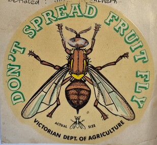 Wodonga & District Historical Society Inc
Document - Fruit Fly Border Express Pass, De Neefe Signs Pty. Ltd, c1960
The permanent fruit fly road blocks in Victoria began in 1958. The first was set up on the Lincoln Causeway between Albury and Wodonga. The aim was to protect the Victorian fruit export industry, the largest in the country. Cars would be stopped and inspected when entering Victoria. At peaks periods, such as Easter and school holidays, there were up to 10 inspectors at the 24 hour checkpoint near the former butter factory on the Lincoln Causeway. Local residents could apply for a pass such as this one which would be displayed on their window, but were still subject to random checks. Hundreds of tonnes of fruit each week was confiscated and pulverised by Department of Agriculture staff. The road block was closed in 1980, partly due to the increased traffic flows and the cost of maintaining inspection points.This image reflects government measures taken to protect the fruit industry in Victoria.A transparent sticker designed to be applied to a car window for motorists to pass through Department of Agriculture fruit fly control points. Instructions for applying the sticker to the window are written on the back of the sticker. It features a large coloured image of a fruit fly as well as a smaller life sized representation of a fruit fly.Around the edge of the circle: "DON'T SPREAD FRUIT FLY/ VICTORIAN DEPT. OF AGRICULTURE? Beside small fruit fly image: "Actual Size"fruit fly control, department of agriculture, fruit fly pass -
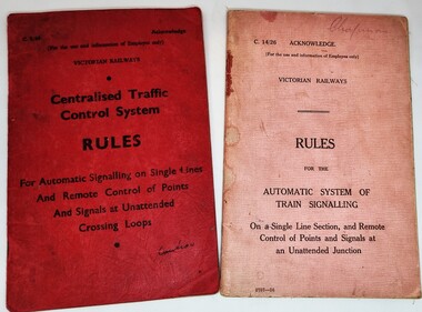 Wodonga & District Historical Society Inc
Manual - Traffic control and signals manuals, Victorian Railways, 1969 & 1927
These manuals were printed by Victorian Railways in 1927 and 1969 and therefore document the changes in signalling systems over this time frame.2 small booklets for instruction related to traffic control and signals, Both have paper covers, one on red paper and the other is pink. Each one is bound with staples along the centre fold and printed in black ink.fiction These manuals were printed by Victorian Railways in 1927 and 1969 and therefore document the changes in signalling systems over this time frame.vline training, railways victoria, railways signalling systems -
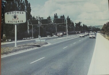 Wodonga & District Historical Society Inc
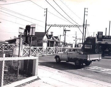
Photograph - Wodonga, Victoria sign and the Fruit Fly check point c1970s
The permanent fruit fly road blocks in Victoria began in 1958. The first was set up on the Lincoln Causeway between Albury and Wodonga. The aim was to protect the Victorian fruit export industry, the largest in the country. Cars would be stopped and inspected when entering Victoria. At peaks periods, such as Easter and school holidays, there were up to 10 inspectors at the 24 hour checkpoint near the former butter factory on the Lincoln Causeway. Local residents could apply for a pass which would be displayed on their window, but were still subject to random checks. Hundreds of tonnes of fruit each week was confiscated and pulverised by Department of Agriculture staff. The road block was closed in 1980, partly due to the increased traffic flows and the cost of maintaining inspection points.This image reflects government measures taken to protect the fruit industry in Victoria.A large image of the LIncoln Causeway at the Victorian/NSW border at Wodonga. The southbound lanes on the right hand side feature overhead signals and traffic light signs to control traffic leading into the Fruit fly inspection checkpoint ahead. The photo is in a wooden frame.On right hand side: Border sign: Wodonga/Victoria and the Victorian State Coat of Arms.fruit fly control, victoria border, lincoln causeway wodonga -
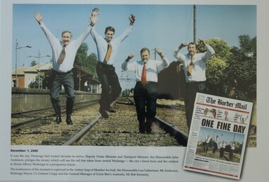 Wodonga & District Historical Society Inc
Photograph - One Fine Day - decision to move Wodonga Railway Line, 2000
On December 1, 2000 it was finally announced that the railway line would be moved away from the centre of the Wodonga CBD after many years of lobbying. Since its opening in 1873 the railway line had crossed High Street, originally called Sydney Road. The railway had bisected the city with level crossing gates frequently stopping the flow of traffic as trains passed through. The Wodonga Rail Bypass project moved Wodonga station from the original central location to a position on a new line on the northern edge of the town. Not only did this release land in the middle of the city for commercial and public use, but also eliminated 10 level crossings. The project actually commenced in 2008 with the last passenger train passing through Wodonga on 8 November 2008. On 23 July 2010, the new rail bypass was opened, and the original line through Wodonga closed. In this image the decision is celebrated by the Member for Indi, the Honourable Lou Lieberman, Deputy Prime Minister and Transport Minister John Anderson, Wodonga Mayor Cr. Graham Crapp and General Manager of Uncle Ben's Australia, Mr Bob Kennedy.This image commemorates a significant occasion in the development of the Central Business District of Wodonga, Victoria.A framed photo of four men celebrating the decision to move the railway out of the centre of Wodonga as well as an image of the from page of the Border Mail newspaper.wodonga railway, wodonga rail bypass, city of wodonga -
 Wodonga & District Historical Society Inc
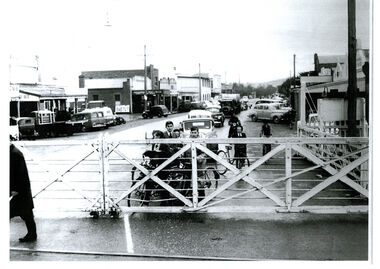
Photograph - High Street, Wodonga Level Crossing, 1954
This image is representative of many photographs illustrating the level crossing in the centre of Wodonga. Since its opening in 1873 the railway line had crossed High Street, originally called Sydney Road. It bisected the city with level crossing gates frequently stopping the flow of traffic and pedestrians as trains passed through. Signal Box B stood on the eastern side of the High Street level crossing and a big wheel closed and opened the gates. On 17th September, 1961, it was replaced by boom gates and flashing lights. The railway crossing was removed from High Street as part of the Wodonga Rail Bypass project. This involved a 5.5 kilometres bypass, the elimination of 11 level crossings and the relocation of the Wodonga station. It was moved from its original central location to a position on a new line on the northern edge of the town. The old station closed on 8 November 2008 and the new station opened on 25 June 2011.This image has local and statewide significance as it captures the former crossing in a major railway system. The railways played a critical role in opening up Victoria and connecting Australia for trade, business, social communication and transport.A black and white photo of the railway level crossing in High Street, Wodonga with gates closed. The Melbourne to Sydney railway line went through the centre of Wodonga and trains frequently held up internal vehicular and pedestrian traffic in the main street. railways wodonga, wodonga railway relocation, high st wodonga rail crossing -
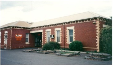 Wodonga & District Historical Society Inc
Photograph - Wodonga old Railway Station complex
\When the railway reached Wodonga from Melbourne on 19th November 1873 the first station building, which included a refreshment room and dining room, was a temporary structure. It was 300 ft. long and was removed and taken to Beechworth when the new station was built in 1874 by contractor J. Richardson. The Goods shed was 100 feet long and was built by Frew & Hill in 1873. One year later it was extended an additional 150 feet by James Nation. The date of the construction of the Locomotive shed is not known but predates 1883. It was a galvanised iron clad building which housed 4 engines on 2 tracks; in 1910 it was extended to 250 feet in length to house six more engines. The location of the railway tracks and station were a constant cause of congestion in the centre of Wodonga as the tracks crossed over Sydney Road (later named High Street). Lines of traffic were frequently banked up as the gates were closed to allow trains to cross. The Wodonga Rail Bypass project moved Wodonga station from the original central location to a position on a new line on the northern edge of the town. Not only did this release land in the middle of the city for commercial and public use, but also eliminated 10 level crossings. The project actually commenced in 2008 with the last passenger train passing through Wodonga on 8 November 2008. On 23 July 2010, the new rail bypass was opened, the original line through Wodonga closed and the station fell quiet. The area has now been redeveloped as Junction Place and the old buildings now house a restaurant, cafe and the Goods Shed Craft Beer Cafe.These images are of local, state and national significance as the Wodonga Railway complex formed a vital link in the Victorian state, interstate and national railway system.A collection of colour photos of the buildings at the former Wodonga Railway Stationwodonga railways, railway station wodonga, junction place wodonga -
 City of Kingston
Photograph - Black and white, c. 1960
Highett railway station with crossing gates closed and traffic waiting.Black and white photograph of Highett railway gates. Gates are closed and a ute is waiting at the crossing.Stamped on reverse: COPYRIGHT / Public Transport Corporation / For re-ordering photographs / Please quote negative No H3985 / Enquiries C/- PIC Photographic Unit / Telephone switchboard 519 1111highett, city of kingston, level crossing, railway station -
 City of Kingston
Photograph - Black and white
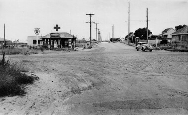
This photograph depicts the road diversion on Nepean Highway that was implemented to allow construction of the railway line underneath the Nepean Highway at Moorabbin. An "Allourie" Cheese, Honey Canned Ham van is prominent on the left of the image, the railway gates are central and the old Moorabbin Station is visble. Beyond the dates, pedestrians are visible crossing the Nepean Highway. This image is part of a larger collection of images from the Public Transport Corporation displaying train stations and streetscapes in what is now the City of Kingston.In 1958 excavations began for the removal of the level crossing gates at the southern end of the Moorabbin shopping centre on Nepean Highway. The station was also lowered below ground. A diversion route was created to enable the flow of traffic in both directions along the highway.Black and white photograph of road diversion on Nepean Highway, Moorabbin to allow the construction of the railway line below the Nepean Highway at Moorabbin and also to trench the station. This image is part of a larger collection of images from the Public Transport Corporation displaying train stations and streetscapes in what is now the City of Kingston.White adhesive dot sticker: Printed black 199 Handwritten in red ink: 80% Handwritten in black ink on yellow Post-It Note: [indecipherable] 199 - Diversion for Crossing Stamped in blue ink: COPYRIGHT Public Transport Corporation, For reordering photographs, Please quote negative No m 5687, Enquiries C/- PTC Photographic Unit, Telephone switchboard 619 1111railway crossing, railway station, city of moorabbin -
 City of Kingston
Photograph - Black and white, c. 1957
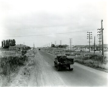
This image shows the urbanisation of a formerly rural area of Moorabbin.Black and white photograph looking west along South Road. There is a truck in the foreground, travelling along the sealed South Road. A car is waiting to exit from Rowan Road. People are walking along the left hand side of the road, and a young person a bike is riding along the right side. They are all going in the same direction as the traffic. The left hand side of the image shows paddocks in the foreground, which houses further back. The right hand side of the image shows suburban houses with electricity poles running the length of the road. Handwritten in blue ink on reverse: 57-523A Handwritten in red ink on reverse: 85% Handwritten in black ink or grey lead: Ch. 6moorabbin, cars, roads, housing -
 City of Kingston
Photograph - Black and white, c. 1950
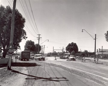
The intersection of Warrigal Road and Nepean Highway is now a major intersection, serviced by traffic lights. In the 1950s it was a joining of two sealed roads, although covered in gravel, and with wide gravel shoulders. There are no traffic signs and the few houses visible are not set very far back from the road. This image is one of many in the collections that focuses on either roads or the railway. The development of roads and the railway was crucial to the ongoing development of the area.Black and white photograph of the intersection of Warrigal Road and Nepean Highway, Mentone. Handwritten in blue ink on reverse: 218 Handwritten in red ink on reverse: 75%mentone, roads, suburbs -
 Bendigo Historical Society Inc.
Administrative record - Spring Gully Gold Mining Co. Fryerstown, Minute Book1903 - 1915, 1924 - 1929
The Spring Gully Gold Mining property consists of Gold Mining Lease No. 2986, Castlemaine, of about 21 acres situated on the Emu Reef, in Spring Gully Fryers. There are two shafts, distant about 300 feet from each other. From one of them large quantities of gold were obtained in former years by previous companies. ( Prospectus of the Spring Gully Mining CompanyMaroon hard cover book, brown leather binding on spine and corners, three hundred and eighty pages. Written on spine of book in gold leaf : 'Minute Book'. Handwritten minute entries from 14th September 1903 to 30th August 1915. Affixed to first page, newspaper clipping from the 'Herald' 13/9/05, with information about the Spring Gully Mine Fryerstown. Page eighty-one has two quotes affixed from 'The Yarraville Chlorination and Ore Reduction Works' High Street Yarraville, July 1905, for works associated with pyrites and blanket sand. Page nine, a handwritten letter affixed to minutes, applying for a block of land 250 feet north of main shaft. Signed by J.S. Potter, H. Hancock, G Murray and T. Tumney. 1.Page one hundred and one: three quotes from 'Edwards' Metallurgical Works' Specimen Hill, Bendigo for pyrites and blanket sand. 2.Page one hundred and fifty five: handwritten letter (copy) from A. Schonfelder re shaft work on the mine and mention of tributors 3. Affixed to inside cover: letter from the 'United Shire of Mount Alexander' April 15th. 1907, regarding the reconstruction of the Vaughan bridge over the Loddon River. 'the benefit that the mines in your district derive from the bridge being open for wood waggons and this being the main traffic and this being the principal cause of the bridges present condition'. 4. Prospectus of the Spring Gully Mining Company, Spring Gull, Fryerstown, two page folded document enclosed inside back cover of book. Prospectus incomplete. (10746.93a) 5. Carbon copy of letter to D.E. Williams Esq, Castlemaine from GlenAthol, Casewick Road, London, January 25th, 1907 regarding two gentlemen who were 'called upon to carry the 'Spring Gullys' through - Mr. H. 'is making a determined effort to bring the matter to a successful issue' Letter signed by George Allan. (10746.93b. 6. Carbon copy of letter from E. Williams, London re proposed new company to acquire the properties of Spring G.M. Coy, Spring Gully G.M. Coy. No. 1, Sth Spring Gully G.M. Coy, Sth Spring Gully G.M. Coy Extended (10746.93c) 7. Handwritten letter to the Chairman and Directors of the Spring Gully G.M. Co. re the appointment of 'Mr. Samuel Morse Battery Manager at once, or accept my resignation as Mining Manager, for we can't agree any longer' Signed by A. Schonfelder. 8. Notice of extraordinary meeting of shareholders in Spring Gully Gold Mining Company No Liability, 22nd November 1906 at Beehive Chambers, Bendigo. Signed W.G. Blackham (Blackham & Garvin) Manager of the Company. (10746.93e) The Minute Book is part of the Margaret Roberts Collection of mining documents.bendigo, margaret roberts, , goldmining, castlemaine, spring gully gold mine, fryertown